ATLAS of ANTIENT GEOGRAPHY by SAMUEL BUTLER 1843John McInnis Auctioneers,LLC4.5(505)See Sold PriceFeb 24, 2024
18TH C. ANTIQUE MAP: FRENCH & INDIAN WAR, FRAMEDThomaston Place Auction Galleries4.4(394)See Sold PriceFeb 24, 2024
Rand McNally Railroad Map Cabinet w/ 21 Railroad MapsRail & Road Auctions4.6(165)See Sold PriceMar 08, 2024
Keith Haring - Ink on New York Map, Best Buddies, Inscribed, Signed, and DatedSapphire Auction Gallery4.1(67)See Sold PriceMar 02, 2024
LATE 17TH C. FRENCH MAP OF THE NEW WORLD BY ALEXIS-HUBERT JAILLOT (1632-1712)Thomaston Place Auction Galleries4.4(394)See Sold PriceFeb 24, 2024
Central Railroad of New Jersey Map of Sandy Hook Route-ca. 1903JM Hobby Supply and Railroad Artifact Auctions4.4(127)See Sold PriceFeb 24, 2024
Lot of Six Mixed Atlas Box Cars-HO Scale-New in BoxJM Hobby Supply and Railroad Artifact Auctions4.4(127)See Sold PriceFeb 25, 2024
Rand McNally/Santa Fe Railroad Map of Iowa-1912JM Hobby Supply and Railroad Artifact Auctions4.4(127)See Sold PriceFeb 24, 2024
NICOLAES VISSCHER (NETHERLANDS, 1618-1709) MAP OF THE NEW WORLDThomaston Place Auction Galleries4.4(394)See Sold PriceFeb 24, 2024
17TH C. WORLD MAP BY NICOLAES VISSCHER (NETHERLANDS, 1618-1709)Thomaston Place Auction Galleries4.4(394)See Sold PriceFeb 24, 2024
Lot of Six Mixed Atlas Cabooses-HO Scale-New in BoxJM Hobby Supply and Railroad Artifact Auctions4.4(127)See Sold PriceFeb 25, 2024
SoldNew Map of Ohio With Its Canals Roads & Distances;Reserve Reduced! Item: New Map of Ohio With Its Canals Roads & Distances; Date: 1847 Cartographer: MITCHELL, SAMUEL AUGUSTUS Publisher: S.A. MITCHELL Size (inches): 14X11.5 copyrighted by H.N. BurrougSee Sold Price
New Map of Ohio With Its Canals Roads & Distances AlongTitle: New Map of Ohio With Its Canals Roads & Distances Along Stage and Steamboat Routes Publication Date: 1846 Cartographer: Tanner, H.S. Publisher: Tanner, H.S. Size: 14 X 11.2 Colored by county. ISee Sold Price
Thomas Cowperthwait: New Map of Virginia, 1850A New Map of Virginia with its Canals, Roads & Distances. Thomas Cowperthwait, 1850. 11.75 x 14. Beautiful impression with great original hand color. Shows Profile of the Chesapeake & Ohio Canal plusSee Sold Price
S.A. Mitchell: New Map of Ohio, 1846Map: A New Map of Ohio with Its Canals, Roads & Distances Cartographer: S. Augustus Mitchell Illustrator: H. Burroughs Edition: First Edition Publisher: S. Augustus Mitchell Date: 1846 Size: 11.5 x 14See Sold Price
S.A. Mitchell New Map Of Ohio, 1846Map: A New Map of Ohio with Its Canals, Roads & Distances Cartographer: S. Augustus Mitchell Illustrator: H. Burroughs Edition: First Edition Publisher: S. Augustus Mitchell Date: 1846 Size: 11.5 x 14See Sold Price
S.A. Mitchell: Map of Ohio, 1847Map: A New Map of Ohio with its Canals Roads & Distances Maker: Samuel Augustus Mitchell Date: 1847 Size: Quarto - 11.5 inches high x 14.5 inches wide Strong striking and fine pastel coloring. Shows pSee Sold Price
Henry S. Tanner: Map of Ohio, 1836Map: A New Map of Ohio with its Canals, Roads & Distances Maker: Henry S. Tanner Date: 1836 Size: Folio - 13.3 inches high x 10.5 inches wide "Tanner's Universal Atlas". Very scarce. Details counties,See Sold Price
1839 Tanner Map of Louisiana -- A New Map of LouisianaTitle: 1839 Tanner Map of Louisiana -- A New Map of Louisiana with Its Canals, Roads & Distances from Place to Place, Along the Stage & Steam Boat Routes Date: 1839, Philadelphia Cartographer: H TanneSee Sold Price
Scarce 1846 Mitchell map of Michigan“A New Map of Michigan with its Canals, Roads & Distances.” 1846 date, found in the scarce 1848 Mitchell New Universal Atlas. Early Mitchell maps are quite scarce, and are some of the best AmericaSee Sold Price
1848 Mitchell map of VirginiaFully hand-colored original, antique and scarce map that encompasses the future state of West Virginia. “A New Map of Virginia with its Canals, Roads & Distances from Place to Place Along the StageSee Sold Price
Sold1848 Mitchell map of VirginiaFully hand-colored original, antique and scarce map that encompasses the future state of West Virginia. “A New Map of Virginia with its Canals, Roads & Distances from Place to Place Along the StageSee Sold Price
Excellent engraved 1850 map of MichiganEngraving with original hand coloring. “A New Map of Michigan with its Canals, Roads & Distances,” by Thomas, Cowperthwait and appearing in A New Universal Atlas published 1854 by CowperthSee Sold Price
SoldA New Map Of Virginia, 1851 folding map, color.[Virginia]. A New Map Of Virginia With its Canals, Roads & Distances from place to place, along the Stage & Steam Boat Routes. Phila: Thomas Cowperthwait/ Samuel Augustus Mitchell, 1851. 10 1/8 x 12 1See Sold Price
Sold3 hand colored maps: Virginia [c1849]-1864.[Virginia]. 3 hand-colored maps. ++ A New Map Of Virginia With its Canals, Roads & Distances from place to place, along the Stage & Steam Boat Routes. Phila: Samuel Augustus Mitchell, c.1849. 11 3/8 xSee Sold Price
SoldENGRAVED MAPS, TWO, C.1838, 16" X 13", MICHIGANENGRAVED MAPS, TWO, C. 1838, 16" X 13", MICHIGAN:Including 1 "New Map of Michigan with its Canals, Roads & Distances" by Henry Schenk Tanner for "Tanner's Universal Atlas", 1839, and 1 "Michigan" engrSee Sold Price
Sold1838 Tanner Map of Louisiana -- A New Map of LouisianaTitle: 1838 Tanner Map of Louisiana -- A New Map of Louisiana with Its Canals, Roads & Distances from Place to Place, Along the Stage & Steam Boat Routes Date: 1839, Philadelphia Cartographer: H TanneSee Sold Price
SoldMAP: NEW MAP OF ARKANSAS, STEAMBOAT ROUTES, 1854Framed map, "A New Map of Arkansas, with its Canals Roads & Distances," c.1854, published by Thomas, Cowperthwait & Company, No. 253 Market Street, Philadelphia, hand colored, includes steamboat routeSee Sold Price
Sold"A New Map of Louisiana with its canals, roads, &"A New Map of Louisiana with its canals, roads, & distances from place to place, along the stage & steam boat routes," 1856, hand colored map, published by Charles Desilver, Phila., framed, H.- 12 in.See Sold Price
SoldTanner map of Michigan 1839Title: A New Map of Michigan with its Canals, Roads & Distances Author: Tanner, Henry Schenk Description: Copper-engraved map, hand-colored. 35x27 cm. (14x10½").Early map of Michigan with county deveSee Sold Price
Sold1854 "NEW MAP OF ARKANSAS", THOMAS COWPERTHWAITFramed, "A New Map of Arkansas, with its Canals Roads * Distances", 1854, "Published by Thomas Cowperthwait & Co, No. 253 Market Street, Philadelphia", hand colored, includes 'Steamboat Routes", sightSee Sold Price
SoldMap of Louisiana, 1856 by Charles Desilver[Antique Hand-Colored Map of Louisiana], 1856, "A New Map of Louisiana with its canals, roads, & distances from place to place, along the stage & steam boat routes", by Charles Desilver, Phila., sightSee Sold Price
SoldSIX 19TH CENTURY MAPS OF ARKANSAS, COLTON, MITCHELLIncludes two 'New Map of Arkansas with its Canals, Roads & Distances,' published by Thomas, Cowperthwait & Co., as well as an S. Augustus Mitchell version, all approximately 17.25 x 13.5 inches. AlsoSee Sold Price
Scarce 1846 Mitchell map of Michigan“A New Map of Michigan with its Canals, Roads & Distances.” 1846 date, found in the scarce 1848 Mitchell New Universal Atlas. Early Mitchell maps are quite scarce, and are some of the best AmericaSee Sold Price
SoldNew Map of New York With Its Canals, Roads & DistancesTitle: New Map of New York With Its Canals, Roads & Distances from Place to Place Along the Stage and Steamboat Routes Publication Date: 1846 Cartographer: TANNER, H.S. Publisher: H.S. TANNERSize: 11.See Sold Price
1892 Adams and Bowles New Road Map of the State of New YorkJM Hobby Supply and Railroad Artifact Auctions4.4(127)See Sold PriceFeb 24, 2024
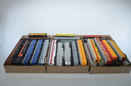
Lot of 47 HO Scale Passenger CarsJM Hobby Supply and Railroad Artifact Auctions4.4(127)See Sold PriceFeb 25, 2024
1963 J.F.K. for US PRESIDENT RE-ELECTION MATERIALJohn McInnis Auctioneers,LLC4.5(505)See Sold PriceFeb 25, 2024
Vintage County Map Of NY State Plate EngravingThe Benefit Shop Foundation Inc.4.3(3k)See Sold PriceFeb 28, 2024
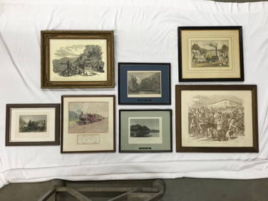
Seven Framed Railroad Lithograph Prints and Art Prints - Baltimore & Ohio, Morristown & Erie, andRail & Road Auctions4.6(165)See Sold PriceMar 07, 2024
1855 Map of New York & Erie Railroad and 1917 Trespassing On Railway Property Is A MisdemeanorRail & Road Auctions4.6(165)See Sold PriceMar 07, 2024
Mixed Group of Railroad Paper, Cross Sections, and Ephemera - Pennsylvania, Reading, Union Pacific,Rail & Road Auctions4.6(165)See Sold PriceMar 07, 2024
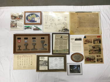
Group of Ten Railroad Photographs, Maps, and Prints - New Jersey, Long Island, and New YorkRail & Road Auctions4.6(165)See Sold PriceMar 07, 2024
Eleven Pieces of North Eastern Railroad Flatware - Chesapeake & Ohio, Baltimore & Ohio, TheRail & Road Auctions4.6(165)See Sold PriceMar 08, 2024
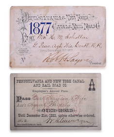
Pair of Pennsylvania & New York Canal & Railroad Co. Annual Passes - 1877 and 1883Rail & Road Auctions4.6(165)See Sold PriceMar 08, 2024
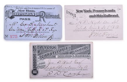
Three New York, Pennsylvania and Ohio Railroad Annual Passes - 1882, 1883, and 1886Rail & Road Auctions4.6(165)See Sold PriceMar 08, 2024
1867 Map of the Railroads of The State of New YorkRail & Road Auctions4.6(165)See Sold PriceMar 08, 2024
67 Reproduction Railroad Pewter Uniform Coat Buttons and Tie Pins - Detroit United Lines, C&O, B&O,Rail & Road Auctions4.6(165)See Sold PriceMar 08, 2024
Rand McNally & Co's New Ideal State and County Survey and Atlas 1911North American Artifact Auctions4.7(201)See Sold PriceApr 20, 2024
Keith Haring Artwork Signed on a Shell Oil New York Road Map 18 in. x 24 in.Donny Malone Auctions4.5(1.8k)See Sold PriceMar 04, 2024
Map: A 19thC engraved and hand coloured map of Buckingham titled A New Map of BuckinghamshireClaydon Auctioneers Ltd4.3(125)See Sold PriceFeb 26, 2024
1750 Bowen Map of Bermuda and St. Kitts -- A New & Accurate Map of Bermudas or Sommer's Islands...Jasper524.5(9.9k)See Sold PriceFeb 27, 2024
1906 Mendenhalls Northern Ohio Road Guide Map BookCheck the Oil Promotions, LLC4.6(346)See Sold PriceMar 10, 2024


![3 hand colored maps: Virginia [c1849]-1864. (1 of 3)](https://p1.liveauctioneers.com/179/14187/4432499_1_x.jpg?height=282&quality=70&version=1193335524)