ATLAS of ANTIENT GEOGRAPHY by SAMUEL BUTLER 1843John McInnis Auctioneers,LLC4.5(505)See Sold PriceFeb 24, 2024
18TH C. ANTIQUE MAP: FRENCH & INDIAN WAR, FRAMEDThomaston Place Auction Galleries4.4(394)See Sold PriceFeb 24, 2024
Rand McNally Railroad Map Cabinet w/ 21 Railroad MapsRail & Road Auctions4.6(165)See Sold PriceMar 08, 2024
Keith Haring - Ink on New York Map, Best Buddies, Inscribed, Signed, and DatedSapphire Auction Gallery4.1(67)See Sold PriceMar 02, 2024
LATE 17TH C. FRENCH MAP OF THE NEW WORLD BY ALEXIS-HUBERT JAILLOT (1632-1712)Thomaston Place Auction Galleries4.4(394)See Sold PriceFeb 24, 2024
Central Railroad of New Jersey Map of Sandy Hook Route-ca. 1903JM Hobby Supply and Railroad Artifact Auctions4.4(127)See Sold PriceFeb 24, 2024
Lot of Six Mixed Atlas Box Cars-HO Scale-New in BoxJM Hobby Supply and Railroad Artifact Auctions4.4(127)See Sold PriceFeb 25, 2024
Rand McNally/Santa Fe Railroad Map of Iowa-1912JM Hobby Supply and Railroad Artifact Auctions4.4(127)See Sold PriceFeb 24, 2024
NICOLAES VISSCHER (NETHERLANDS, 1618-1709) MAP OF THE NEW WORLDThomaston Place Auction Galleries4.4(394)See Sold PriceFeb 24, 2024
17TH C. WORLD MAP BY NICOLAES VISSCHER (NETHERLANDS, 1618-1709)Thomaston Place Auction Galleries4.4(394)See Sold PriceFeb 24, 2024
Lot of Six Mixed Atlas Cabooses-HO Scale-New in BoxJM Hobby Supply and Railroad Artifact Auctions4.4(127)See Sold PriceFeb 25, 2024
SoldNew Map of New York With Its Canals, Roads & DistancesTitle: New Map of New York With Its Canals, Roads & Distances from Place to Place Along the Stage and Steamboat Routes Publication Date: 1846 Cartographer: TANNER, H.S. Publisher: H.S. TANNERSize: 11.See Sold Price
New Map of New York With Its Canals Roads & DistancesTitle/Content of Map: New Map of New York With Its Canals Roads & Distances Date: 1850 Cartographer: THOMAS, COWPERTHWAIT & CO. Publisher: THOMAS, COWPERTHWAIT & CO. Size: 11.5Height - 14Width Map detSee Sold Price
New Map of New York With Its Canals, Roads andTitle: New Map of New York With Its Canals, Roads and Distances Prublication Date: 1850 Cartographer: MITCHELL, S.A. Publisher: THOMAS, COWPERTHWAIT & CO. Size: 10Height - 12.3Width Additional InformaSee Sold Price
SoldA MAP, UNITED STATES OF AMERICA, J. CALVIN SMITH, NEW YA MAP, UNITED STATES OF AMERICA, J. CALVIN SMITH, NEW YORK, SHERMAN & SMITH, 1846, for travelers showing the railroad, canals and stage roads with distances. 22" x 26". Framed. NOTE: scale ca. 1:4, 25See Sold Price
S.A. Mitchell: New Map of New York, 1846Map: A New Map of New York with Its Canals, Roads & Distances Cartographer: S. Augustus Mitchell Illustrator: H. Burroughs Edition: First Edition Publisher: S. Augustus Mitchell Date: 1846 Size: 11.75See Sold Price
SoldNew Map of Ohio With Its Canals Roads & Distances;Reserve Reduced! Item: New Map of Ohio With Its Canals Roads & Distances; Date: 1847 Cartographer: MITCHELL, SAMUEL AUGUSTUS Publisher: S.A. MITCHELL Size (inches): 14X11.5 copyrighted by H.N. BurrougSee Sold Price
New Map of Ohio With Its Canals Roads & Distances AlongTitle: New Map of Ohio With Its Canals Roads & Distances Along Stage and Steamboat Routes Publication Date: 1846 Cartographer: Tanner, H.S. Publisher: Tanner, H.S. Size: 14 X 11.2 Colored by county. ISee Sold Price
1839 Tanner Map of Louisiana -- A New Map of LouisianaTitle: 1839 Tanner Map of Louisiana -- A New Map of Louisiana with Its Canals, Roads & Distances from Place to Place, Along the Stage & Steam Boat Routes Date: 1839, Philadelphia Cartographer: H TanneSee Sold Price
Scarce 1846 Mitchell map of Michigan“A New Map of Michigan with its Canals, Roads & Distances.” 1846 date, found in the scarce 1848 Mitchell New Universal Atlas. Early Mitchell maps are quite scarce, and are some of the best AmericaSee Sold Price
Thomas Cowperthwait: New Map of Virginia, 1850A New Map of Virginia with its Canals, Roads & Distances. Thomas Cowperthwait, 1850. 11.75 x 14. Beautiful impression with great original hand color. Shows Profile of the Chesapeake & Ohio Canal plusSee Sold Price
Excellent engraved 1850 map of MichiganEngraving with original hand coloring. “A New Map of Michigan with its Canals, Roads & Distances,” by Thomas, Cowperthwait and appearing in A New Universal Atlas published 1854 by CowperthSee Sold Price
SoldA New Map Of Virginia, 1851 folding map, color.[Virginia]. A New Map Of Virginia With its Canals, Roads & Distances from place to place, along the Stage & Steam Boat Routes. Phila: Thomas Cowperthwait/ Samuel Augustus Mitchell, 1851. 10 1/8 x 12 1See Sold Price
Sold1838 Tanner Map of Louisiana -- A New Map of LouisianaTitle: 1838 Tanner Map of Louisiana -- A New Map of Louisiana with Its Canals, Roads & Distances from Place to Place, Along the Stage & Steam Boat Routes Date: 1839, Philadelphia Cartographer: H TanneSee Sold Price
SoldMAP: NEW MAP OF ARKANSAS, STEAMBOAT ROUTES, 1854Framed map, "A New Map of Arkansas, with its Canals Roads & Distances," c.1854, published by Thomas, Cowperthwait & Company, No. 253 Market Street, Philadelphia, hand colored, includes steamboat routeSee Sold Price
Sold"A New Map of Louisiana with its canals, roads, &"A New Map of Louisiana with its canals, roads, & distances from place to place, along the stage & steam boat routes," 1856, hand colored map, published by Charles Desilver, Phila., framed, H.- 12 in.See Sold Price
Sold1854 "NEW MAP OF ARKANSAS", THOMAS COWPERTHWAITFramed, "A New Map of Arkansas, with its Canals Roads * Distances", 1854, "Published by Thomas Cowperthwait & Co, No. 253 Market Street, Philadelphia", hand colored, includes 'Steamboat Routes", sightSee Sold Price
Scarce 1846 Mitchell map of Michigan“A New Map of Michigan with its Canals, Roads & Distances.” 1846 date, found in the scarce 1848 Mitchell New Universal Atlas. Early Mitchell maps are quite scarce, and are some of the best AmericaSee Sold Price
Scarce 1846 Illinois map by Mitchell“A New Map of Illinois with its Proposed Canals, Roads & Distances (insets of Lead Region & Steam Boat Routes).”With 1846 copyright, found in the scarce 1848 Mitchell New Universal Atlas. Early MiSee Sold Price
SoldMap of LouisianaA New Map of Louisiana With its Canals, Roads and Distances From Place to Place Along the Stage and Steamboat Routes, engraving, 13-3/4" x 17", published by Thomas Cowperthwait & Co., Philadelphia, 18See Sold Price
SoldScarce 1846 Mitchell map of S. Carolina“A New Map of South Carolina with its Canals, Roads & Distances from Place to Place Along the Stage & Steam Boat Routes.” Dated 1846, found in the scarce 1848 Mitchell New Universal Atlas. OriginaSee Sold Price
Scarce 1846 Mitchell map of S. Carolina“A New Map of South Carolina with its Canals, Roads & Distances from Place to Place Along the Stage & Steam Boat Routes.” Dated 1846, found in the scarce 1848 Mitchell New Universal Atlas. OriginaSee Sold Price
SoldAntique 'New Map of Illinois' Stage and SteamboatAntique 'New Map of Illinois', with proposed canals, roads and distances from place to place along the stage and steamboat routes, published by S. Augustus Mitchell, NE Corner of Market and 7th StreetSee Sold Price
Sold"A New Map of Louisiana, with its Canals, Roads, and"A New Map of Louisiana, with its Canals, Roads, and Distances," 1846, by Augustus Mitchell, hand colored, framed, H.- 11 3/8 in., W.- 14 1/8 in.See Sold Price
Scarce 1846 Illinois map by Mitchell“A New Map of Illinois with its Proposed Canals, Roads & Distances (insets of Lead Region & Steam Boat Routes).”With 1846 copyright, found in the scarce 1848 Mitchell New Universal Atlas. Early MiSee Sold Price
1892 Adams and Bowles New Road Map of the State of New YorkJM Hobby Supply and Railroad Artifact Auctions4.4(127)See Sold PriceFeb 24, 2024
Crams Railroad Map of New York-1881JM Hobby Supply and Railroad Artifact Auctions4.4(127)See Sold PriceFeb 24, 2024
Crams Township and Railroad Map of New York-1890JM Hobby Supply and Railroad Artifact Auctions4.4(127)See Sold PriceFeb 24, 2024
Vintage County Map Of NY State Plate EngravingThe Benefit Shop Foundation Inc.4.3(3k)See Sold PriceFeb 28, 2024
Group of New York Central Railroad Paper - Rule Books, Employee Timetables, Stationary, Log Books,Rail & Road Auctions4.6(165)See Sold PriceMar 07, 2024
Early Pennsylvania Railroad Literature - 1881 New York and Chicago Limited Timetable Brochure andRail & Road Auctions4.6(165)See Sold PriceMar 07, 2024
1855 Map of New York & Erie Railroad and 1917 Trespassing On Railway Property Is A MisdemeanorRail & Road Auctions4.6(165)See Sold PriceMar 07, 2024
Group of Ten Railroad Photographs, Maps, and Prints - New Jersey, Long Island, and New YorkRail & Road Auctions4.6(165)See Sold PriceMar 07, 2024
Keith Haring - Ink on New York Map, Best Buddies, Inscribed, Signed, and DatedSapphire Auction Gallery4.1(67)See Sold PriceMar 02, 2024
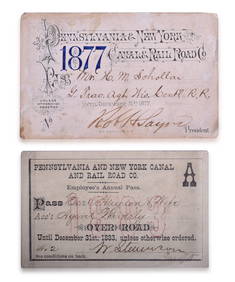
Pair of Pennsylvania & New York Canal & Railroad Co. Annual Passes - 1877 and 1883Rail & Road Auctions4.6(165)See Sold PriceMar 08, 2024
1867 Map of the Railroads of The State of New YorkRail & Road Auctions4.6(165)See Sold PriceMar 08, 2024
Alfred Henry Maurer (American, 1868-1932) - Country RoadFreeman's | Hindman4.5(158)See Sold PriceFeb 28, 2024
1849 THE NEW-ENGLAND MERCANTILE UNIONNorth American Artifact Auctions4.7(201)See Sold PriceApr 20, 2024
Keith Haring Artwork Signed on a Shell Oil New York Road Map 18 in. x 24 in.Donny Malone Auctions4.5(1.8k)See Sold PriceMar 04, 2024
Map: A 19thC engraved and hand coloured map of Buckingham titled A New Map of BuckinghamshireClaydon Auctioneers Ltd4.3(125)See Sold PriceFeb 26, 2024
Black and white map of part of New York City (mostly Manhattan)Proverde Auctions4.3(3)See Sold PriceFeb 28, 2024
Map Inside Soho - Manhattan - New York Magazine 1974Proverde Auctions4.3(3)See Sold PriceFeb 28, 2024
Laminated Unique Media New York City MapRapid Estate Liquidators and Auction Gallery4.5(1.1k)See Sold PriceFeb 29, 2024
Hudson River Map & North American Postcards, 45Auctions at Showplace4.6(744)See Sold PriceFeb 13, 2025