ATLAS of ANTIENT GEOGRAPHY by SAMUEL BUTLER 1843John McInnis Auctioneers,LLC4.6(502)See Sold PriceFeb 24, 2024
18TH C. ANTIQUE MAP: FRENCH & INDIAN WAR, FRAMEDThomaston Place Auction Galleries4.4(386)See Sold PriceFeb 24, 2024
Rand McNally Railroad Map Cabinet w/ 21 Railroad MapsRail & Road Auctions4.6(165)See Sold PriceMar 08, 2024
Keith Haring - Ink on New York Map, Best Buddies, Inscribed, Signed, and DatedSapphire Auction Gallery4(67)See Sold PriceMar 02, 2024
LATE 17TH C. FRENCH MAP OF THE NEW WORLD BY ALEXIS-HUBERT JAILLOT (1632-1712)Thomaston Place Auction Galleries4.4(386)See Sold PriceFeb 24, 2024
Central Railroad of New Jersey Map of Sandy Hook Route-ca. 1903JM Hobby Supply and Railroad Artifact Auctions4.4(126)See Sold PriceFeb 24, 2024
Lot of Six Mixed Atlas Box Cars-HO Scale-New in BoxJM Hobby Supply and Railroad Artifact Auctions4.4(126)See Sold PriceFeb 25, 2024
Rand McNally/Santa Fe Railroad Map of Iowa-1912JM Hobby Supply and Railroad Artifact Auctions4.4(126)See Sold PriceFeb 24, 2024
NICOLAES VISSCHER (NETHERLANDS, 1618-1709) MAP OF THE NEW WORLDThomaston Place Auction Galleries4.4(386)See Sold PriceFeb 24, 2024
17TH C. WORLD MAP BY NICOLAES VISSCHER (NETHERLANDS, 1618-1709)Thomaston Place Auction Galleries4.4(386)See Sold PriceFeb 24, 2024
Lot of Six Mixed Atlas Cabooses-HO Scale-New in BoxJM Hobby Supply and Railroad Artifact Auctions4.4(126)See Sold PriceFeb 25, 2024
New Holland & Asiatic islands Australia New Zealand Melanesia THOMSON 1817 mapTitle: "New Holland & Asiatic islands" Australia New Zealand Melanesia THOMSON 1817 map Description: New Holland and Asiatic islands' by Drawn & engraved for John Thomson's "New General Atlas" (PublisSee Sold Price
Sold"New Holland & Asiatic islands" Australia New ZealandTITLE/CONTENT OF MAP: 'New Holland and Asiatic islands' The top image on the right hand side shows the entire map. To view a close up of the map showing the level of printed detail, please click on thSee Sold Price
New Holland & Asiatic islands Australia New ZealandTITLE/CONTENT OF MAP: 'New Holland and Asiatic islands' The top image on the right hand side shows the entire map. To view a close up of the map showing the level of printed detail, please click on thSee Sold Price
SoldNew Holland & Asiatic Islands Map, Thomson, 1817TITLE/CONTENT OF MAP: 'New Holland and Asiatic islands' DATE PRINTED: 1817 IMAGE SIZE: Approx 53.0 x 65.0cm, 21 x 25.5 inches (Large); Please note that this is a folding map. TYPE: Antique early 19thSee Sold Price
New Holland & Asiatic Islands 1817 MapNew Holland & Asiatic Islands 1817 Map. Title/content of Map: 'new Holland and Asiatic Islands' This Map Is Folding Hence the Centrefold Line May Show on the Image Below date Printed: 1817 image Size:See Sold Price
SoldThomson: Antique Map of New Holland (Australia), 1814Map: New Holland and Asiatic Islands Cartographer: Thomson Place & Date: Edinburgh / 1814/1817 Size: 24 1/4" x 19 3/4" Condition: overprinting and some staining; repaired splits along centerfold and nSee Sold Price
Thomson: Antique Map of Australia & Asiatic IslandsMap: New Holland and Asiatic Islands Cartographer: Thomson Place & Date: Edinburgh / 1814/1817 Size: 24 1/4" x 19 3/4" Condition: overprinting and some staining; repaired splits along centerfold and nSee Sold Price
New Holland And Asiatic Isles.Title: New Holland And Asiatic Isles. Cartographer: THOMSON, JOHN & CO. Publisher: JOHN THOMSON, JUNR. & CO. Height: 19.6 Width: 24.25 No.55 from Thomson's New General Atlas 1817. J. & G. Menzies, engSee Sold Price
SoldWeller: Map of Pacific, Hawaii Australia New ZealandTITLE/CONTENT OF MAP: 'The Pacific Ocean'. Sandwich Islands/Hawaii Australia New Zealand This map is folding hence the centrefold line may show on the image below DATE PRINTED: 1862 IMAGE SIZE: ApproxSee Sold Price
SoldAllodi (Pietro) OceaniaAllodi (Pietro) Oceania, showing Indonesia, the Philippines, Australia, New Zealand, Melanesia, Mirconesia and Polynesia, with inset map of Victoria and New South Wales, engraved map with origSee Sold Price
Thomson: Map of New Holland And Asiatic Isles 1814Title/Content of Map: New Holland And Asiatic Isles Cartographer: THOMSON, JOHN Size: 19.5X24.3 From "Thomson's New General Atlas." Interior of "New Holland unexplored." The coast and its character deSee Sold Price
1874 Map of Australia New ZealandTitle: 1874 Map of Australia New Zealand Additional Information: Lithograph map of Australia New Zealand and Pacific Islands by Flemming, German printing, 1874. Colored outling. Fine, measures 17.5 xSee Sold Price
SoldAntique New Zealand and Australia Maps,Antique New Zealand and Australia Maps, as follows: "The Islands of New Zealand," (London: The Society for the Diffusion of Useful Knowledge, ca. 1840), outline color, matted and framed to an overallSee Sold Price
SoldThomson: Southern HemisphereA fascinating southern hemisphere focused on the "Antarctic Ocean" and encompasing Australia, New Zealand and all of Oceania, from Thomson's influential New General Atlas. Thomson; Edinburgh / 1816/18See Sold Price
Mitchell: Oceania, Australia with Hawaii InsetThe beautifully detailed and colored map of the Pacific, encompassing East Asia, Malaysia, Australasia (New Guinea, Australia, New Zealand), the island groups of Oceania, and a large part of North andSee Sold Price
SoldMap: A 19thC engraved map of Australia, New Zealand andMap: A 19thC engraved map of Australia, New Zealand and East India Islands, engraved and published by G. F. Crutchley. Approx. 15 1/2" x 18 1/2"See Sold Price
SoldMap: A 19thC engraved map of Australia, New Zealand andMap: A 19thC engraved map of Australia, New Zealand and East India Islands, engraved and published by G. F. Crutchley. Approx. 15 1/2" x 18 1/2"See Sold Price
New Holland And Asiatic IslesTitle: New Holland And Asiatic Isles Printing Date: 1814 Cartographer: THOMSON, JOHN Publisher: JOHN THOMSON & CO. Size: 19.5Height - 24.3Width Additional Information: From "Thomson's New General AtlaSee Sold Price
New Holland And Asiatic Isles.Title: New Holland And Asiatic Isles. Publication Date: 1817 Cartographer: THOMSON, JOHN & CO. Publisher: JOHN THOMSON, JUNR. & CO. Dimension: 19.6Height - 24.25Width No.55 from Thomson's New GeneralSee Sold Price
1874 Australian HandbookS W Silver & Co.'s Handbook for Australia & New Zealand (Including Also the Fiji Islands) with New Map of the Colonies Second Edition. London S W Silver 1874. Original cloth and in a custom made box.See Sold Price
The World on Mercator's Projection by John Bartholomew 1859 old antique mapCAPTION PRINTED BELOW PICTURE: 'The World on Mercator's Projection' Small fragments of the Antarctic coast are shown. The antipodes are named as "New Holland or Australia", while the islands of New ZeSee Sold Price
Australia, New Zealand and New Guinea. 1846 by A and C BlackTitle: Australia, New Zealand and New Guinea. 1846 by A and C Black Date/Period: 1846 Materials: Copperplate engraved Size: 12 x 17" Australia, New Zealand, and New Guinea with Pacific Islands. From "See Sold Price
SoldSilver & Co, Australia & New ZealandSilver & Co. (S.W.) Handbook for Australia & New Zealand (including also the Fiji Islands),fifth edition, large coloured folding map, 16 pp. advertisements at rear, original cloth, gilt, extreSee Sold Price
SoldTallis (John) New Zealand; PolynesiaTallis (John) New Zealand; Polynesia, or Islands in the Pacific Ocean; Australia,with decorative borders and vignette views, 3 engraved maps by Rapkin, with original outline hand-colouring, c.See Sold Price
1789 Captain James Cook Life & Voyages Australia New Zealand Hawaii KippisSchilb Antiquarian Rare Books4.8(421)See Sold PriceMar 10, 2024
Peter Williams (NY,New Zealand,1934-2018) oil paintingBroward Auction Gallery4.8(277)See Sold PriceMar 31, 2024
EARLY 18TH C. DUTCH CHART OF PACIFIC OCEAN BY FREDERIK DE WIT (1629-1706) WITH CALIFORNIA AS ANThomaston Place Auction Galleries4.4(386)See Sold PriceFeb 24, 2024
Portfolio of 15 County Maps by Robert Morden (English 1650-1703)Nadeau's Auction Gallery4.7(401)See Sold PriceFeb 24, 2024
Group of Canada, New Zealand, Australia, Great Britain Silver CoinsDana J. Tharp Auctions4.7(268)See Sold PriceFeb 24, 2024
Group of Ten Railroad Photographs, Maps, and Prints - New Jersey, Long Island, and New YorkRail & Road Auctions4.6(165)See Sold PriceMar 07, 2024
1849 THE NEW-ENGLAND MERCANTILE UNIONNorth American Artifact Auctions4.6(182)See Sold PriceApr 20, 2024
Sarah A Boardman (UK,CO,20/21C) oil paintingBroward Auction Gallery4.8(277)See Sold PriceMay 05, 2024
D'Entrecasteaux - Map of Australia (New Holland), New Zealand, and southern Asia and surroundingTrillium Antique Prints & Rare Books4.5(30)See Sold PriceFeb 24, 2024
England to Australia.- Wickes (Edmund) Log for the Ship Strathfieldsaye Bound for Port Philip whichForum Auctions4.3(52)See Sold PriceFeb 29, 2024
West Indies Islands. Guadaloupe. | Mariegalante &C. | Antigua.Jasper524.5(9.8k)See Sold PriceFeb 27, 2024
1750 Bowen Map of Bermuda and St. Kitts -- A New & Accurate Map of Bermudas or Sommer's Islands...Jasper524.5(9.8k)See Sold PriceFeb 27, 2024
New and Correct Map of North America With the West India Islands,Jasper524.5(9.8k)See Sold PriceFeb 27, 2024
Pre-colonial Africa. Mountains of Kong/Moon. Caravan routes. THOMSON 1817 mapJasper524.5(9.8k)See Sold PriceFeb 28, 2024
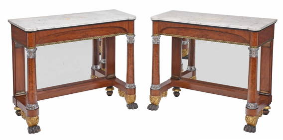
Rare Pair of American Classical Cut Glass Mounted and Gilt Stenciled Burlwood Pier TablesBrunk Auctions4.6(463)See Sold PriceMar 08, 2024
Large Group of Mixed Dates UK and Territories Coinage Australia New Zealand Hong KongGCB Estate Sales4.5(86)See Sold PriceMar 02, 2024
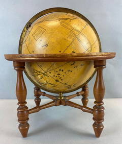
Antique Josiah Loring Terrestrial 1850s GlobeMatthew Bullock Auctioneers4.7(1.8k)See Sold PriceMar 02, 2024
Mauritz Frederik Hendrick De Haas (1832 - 1895) New York/ HollandCutler Bay Auctions4.5(168)See Sold PriceFeb 29, 2024