ATLAS of ANTIENT GEOGRAPHY by SAMUEL BUTLER 1843John McInnis Auctioneers,LLC4.5(505)See Sold PriceFeb 24, 2024
18TH C. ANTIQUE MAP: FRENCH & INDIAN WAR, FRAMEDThomaston Place Auction Galleries4.4(393)See Sold PriceFeb 24, 2024
Rand McNally Railroad Map Cabinet w/ 21 Railroad MapsRail & Road Auctions4.6(165)See Sold PriceMar 08, 2024
Keith Haring - Ink on New York Map, Best Buddies, Inscribed, Signed, and DatedSapphire Auction Gallery4(67)See Sold PriceMar 02, 2024
LATE 17TH C. FRENCH MAP OF THE NEW WORLD BY ALEXIS-HUBERT JAILLOT (1632-1712)Thomaston Place Auction Galleries4.4(393)See Sold PriceFeb 24, 2024
Central Railroad of New Jersey Map of Sandy Hook Route-ca. 1903JM Hobby Supply and Railroad Artifact Auctions4.4(127)See Sold PriceFeb 24, 2024
Lot of Six Mixed Atlas Box Cars-HO Scale-New in BoxJM Hobby Supply and Railroad Artifact Auctions4.4(127)See Sold PriceFeb 25, 2024
Rand McNally/Santa Fe Railroad Map of Iowa-1912JM Hobby Supply and Railroad Artifact Auctions4.4(127)See Sold PriceFeb 24, 2024
NICOLAES VISSCHER (NETHERLANDS, 1618-1709) MAP OF THE NEW WORLDThomaston Place Auction Galleries4.4(393)See Sold PriceFeb 24, 2024
17TH C. WORLD MAP BY NICOLAES VISSCHER (NETHERLANDS, 1618-1709)Thomaston Place Auction Galleries4.4(393)See Sold PriceFeb 24, 2024
Lot of Six Mixed Atlas Cabooses-HO Scale-New in BoxJM Hobby Supply and Railroad Artifact Auctions4.4(127)See Sold PriceFeb 25, 2024
A New & Accurate Map of China, Drawn from Surveys MadeTitle/Content of Map: A New & Accurate Map of China, Drawn from Surveys Made by the Jesuite Missionaries, Cartographer: BOWEN, EMAN. Height (inches): 13.5 Width (inches): 16.5Year: 1748 by order of thSee Sold Price
New & Accurate Map of China, Drawn from Surveys Made byTitle/Content of Map: New & Accurate Map of China, Drawn from Surveys Made by the Jesuite Missionaries, Date: 1748 Cartographer: Bowen, Eman. Size: 13.5Height - 16.5Width Publisher: T. Woodward, S. BiSee Sold Price
New & Accurate Map of China, Drawn from Surveys Made byReserve Reduced! Title: New & Accurate Map of China, Drawn from Surveys Made by the Jesuite Missionaries, Publication Date: 1748 Cartographer: Bowen, Eman. Material/Medium: T. Woodward, S. Birt, Etc.See Sold Price
SoldE. Bowen, A New & Accurate Map of China. 1747Emanuel Bowen, 'A New & Accurate Map of China Drawn from Surveys made by Jesuit Missionaries'. London, 1747. Impression measures 14x17'' on 16x18.25'' sheet. Slight discoloration of paper around lowerSee Sold Price
SoldBowen map of China 1747Heading: (China) Author: Bowen, Emanuel Title: A New & Accurate Map of China Drawn from Surveys made by the Jesuit Missionaries, by Order of the Emperor… Place Published: London Publisher: Date PSee Sold Price
SoldAN INTERESTING FRAMED 18TH CENTURY ENGLISH ENGRAVED MAPAN INTERESTING FRAMED 18TH CENTURY ENGLISH ENGRAVED MAP PRINT OF CHINA AFTER BOWAN, entitled ‘A New & Accurate Map of China Drawn From Surveys Made by the Jesuit Missionaries, by Order of the EmperoSee Sold Price
SoldBowen map of Asia 1757Heading: (Asia) Author: Bowen, Emanuel Title: A New & Accurate Map of Asia Drawn from Actual Surveys and otherwise Collected from Journal; assisted by the Most approved Modern Maps & Charts Place PublSee Sold Price
Emanuel Bowen 18th Century MapOrnamental title cartouche upper right "A New & Accurate Map of Spain and Portugal. Drawn from Surveys assisted by ye. most approved Modern Maps and Charts. The whole being Regulated by Astronomical OSee Sold Price
MAP, Spain & Portugal, BowenSpain & Portugal. Emanuel Bowen, A New & Accurate Map of Spain and Portugal. Drawn from Surveys Assisted by ye Most Approved Modern Maps and Charts..., from The Maps and Charts to the Modern Part of tSee Sold Price
SoldDetailed map of Scotland 1747Heading: Author: Bowen, Emanuel Title: A New & Accurate Map of Scotland or North Britain. drawn from surveys and most approved Maps and Charts... Place Published: London Publisher: Date PublisheSee Sold Price
Spain & Portugal 1747Heading: Author: Bowen, Emanuel Title: A New & Accurate Map of Spain & Portugal Drawn from the Latest Surveys & Most Approved Maps & Charts Place Published: London Publisher: Date Published:See Sold Price
SoldEmanuel Bowen, A New & Accurate Map of Louisiana......with Part of Florida and Canada and the Adjacent Countries Drawn from Surveys assisted by the most approved English & French Maps & Charts., copperplate engraving with outline color, from A CompletSee Sold Price
MAP - Russia in Europe. BowenRussia in Europe. Emanuel Bowen, A New & Accurate Map of Moscovy, of Russia in Europe, with its Acquisitions. Drawn from Surveys & the Best Modern Nams. The Whole Being Regulated by Astronomical ObserSee Sold Price
"A new and accurate map of Great Britain & Ireland" byTITLE/CONTENT OF MAP: 'A new and accurate map of Great Britain & Ireland together with their respective islands &c. drawn from surveys and the most approved maps and charts, the whole being regulatedSee Sold Price
"A new and accurate map of Great Britain & Ireland" byTITLE/CONTENT OF MAP: 'A new and accurate map of Great Britain & Ireland together with their respective islands &c. drawn from surveys and the most approved maps and charts, the whole being regulatedSee Sold Price
"A new and accurate map of Great Britain & Ireland" byTITLE/CONTENT OF MAP: 'A new and accurate map of Great Britain & Ireland together with their respective islands &c. drawn from surveys and the most approved maps and charts, the whole being regulatedSee Sold Price
A new and accurate map of Great Britain & Ireland byTITLE/CONTENT OF MAP: 'A new and accurate map of Great Britain & Ireland together with their respective islands &c. drawn from surveys and the most approved maps and charts, the whole being regulatedSee Sold Price
SoldEmanuel Bowen 18th Century MapOrnamental title cartouche upper left "A New and Accurate Map of Great Britain & Ireland, together with their respective Islands &c. Drawn from Surveys, and the most approved Maps and Charts. The wholSee Sold Price
SoldBowen, ''...North & South Caroina &C.'' [mid-1700[United States: Southeast]. Emanuel Bowen. A New & Accurate Map Of The Provinces Of North & South Carolina Georgia &C. Drawn from late Surveys and regulated by Astronl. Observatns. Double-page engraveSee Sold Price
MAP OF SOUTH BRITAIN AND IRELAND, EMANUEL BOWEN, 1744Emanuel Bowen: “A New and Accurate Map of Great Britain & Ireland, Together with Their Respective Islands &c. Drawn from Surveys, and the Most Approved Maps and Charts, the Whole Being Regulated bySee Sold Price
SoldThe Empire of China, map, Lon: Sayer, 1790[China]. M. Bowen after D'Anville. The Empire Of China, With Its Principal Divisions; Drawn from the Surveys made by the Jesuits: with Improvements and Additions, from the Maps of Monsr. D'Anville. DoSee Sold Price
SoldEMANUEL BOWEN (BRITISH, 1720-1767) MAP OF THE SOUTHEASTEMANUEL BOWEN (BRITISH, 1720-1767) MAP OF THE SOUTHEAST hand-colored engraving on laid paper, A New and Accurate Map of the Provinces of North & South Carolina, Georgia, &c. Drawn from late Surveys anSee Sold Price
SoldBOWEN, EMANUEL. A New & Accurate Map of all the Known WBOWEN, EMANUEL A New & Accurate Map of all the Known World, Drawn from the latest & most Authentic Surveys, assisted by the best & most approved Modern Maps and Charts, &c., Wherein all the DiscoverieSee Sold Price
SoldBowen, Map of Russia, to Bering Strait, c.1747[Russia]. Emanuel Bowen. A New & Accurate Map Of The Whole Russian Empire, As Contain'd Both In Europe And Asia. Drawn from authentic Journals, Surveys, and most approved Modern Maps, and Regulated bySee Sold Price
Alaska RR McKinley Pattern SaucerJM Hobby Supply and Railroad Artifact Auctions4.4(127)See Sold PriceFeb 24, 2024
Two Baltimore and Ohio RR Capital Dome Logo Soup BowlsJM Hobby Supply and Railroad Artifact Auctions4.4(127)See Sold PriceFeb 24, 2024
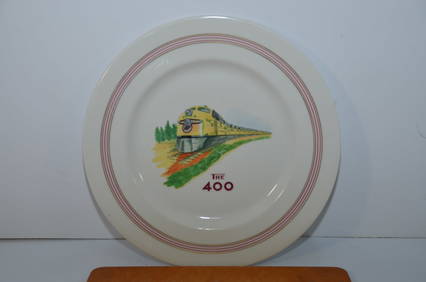
Chicago and Northwestern RY Flambeau 400 PlateJM Hobby Supply and Railroad Artifact Auctions4.4(127)See Sold PriceFeb 24, 2024
Vintage County Map Of NY State Plate EngravingThe Benefit Shop Foundation Inc.4.3(2.9k)See Sold PriceFeb 28, 2024
[ARCTIC]. BOWEN, Emanuel. A New & Accurate Map of the North...Potter & Potter Auctions4.6(545)See Sold PriceMar 07, 2024
1764 MAP OF COUNTRIES THIRTY MILES ROUND LONDON antique 12.5 by 15"Jasper524.5(9.9k)See Sold PriceFeb 27, 2024
1738 RUSSIA SIBERIA & GREAT TARTARY Description illustrated ANTIQUE in ENGLISHJasper524.5(9.9k)See Sold PriceFeb 27, 2024
Birmingham.- Commercial map.- Smith (J. Pigott) To the Right Honourable William Earl of Dartmouth...Forum Auctions4.3(53)See Sold PriceFeb 29, 2024
Set of 3 Pants and 3 Skirts Including Angina, Lafayette 148, Escada, Margaretha Lev, FaconableCain Modern Auctions4.4(45)See Sold PriceFeb 28, 2024
1750 Bowen Map of Bermuda and St. Kitts -- A New & Accurate Map of Bermudas or Sommer's Islands...Jasper524.5(9.9k)See Sold PriceFeb 27, 2024
Handmade vintage Art Deco Chinese runner 2.3' x 9.9' (70cm x 303cm) 1970sJasper524.5(9.9k)See Sold PriceFeb 28, 2024
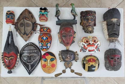
Mask Collection from All Over the World - 31 in TotalKing's Auctions Inc4.2(121)See Sold PriceDec 29, 2024


![[ARCTIC]. BOWEN, Emanuel. A New & Accurate Map of the North... (1 of 1)](https://p1.liveauctioneers.com/928/318880/171360917_1_x.jpg?height=282&quality=70&version=1707501302)