SoldNETTE - 1926 PRR Property Atlas, MapsBound Book, though binding is weak. Published by GW Bromley. Covers Main Lines Overbrook to Paoli, 31 full-color plates, very framable or for historic records, Heavy! O/w clean C6See Sold Price
SoldPRR Property Atlas, Overbrook to Malvern (c. 1887)J.L. Smith. Atlas of Properties Along the Pennsylvania Railroad from Overbrook to Malvern, with index map & 34 area maps. Philadelphia, c. 1887.CONDITION: Covers lacking; partially disbound, most mapsSee Sold Price
SoldJo Mora, Map of Monterey, 1926Heading: Author: Mora, Jo Title: [Map of Monterey Peninsula] Place Published: Monterey Publisher:Del Monte Properties Company Date Published: [1926] Description: Color pictSee Sold Price
Queen Milling and Mining maps (112341)Four maps for the Queen Mining and Milling property Elmore County Idaho. Original pen and ink on paper. Survey J.L. McPherson 1926. Three other smaller maps meant for illustrations in a report. A) plaSee Sold Price
Quenn Milling and Mining maps (112341)Four maps for the Queen Mining and Milling property Elmore County Idaho. Original pen and and ink on paper. Survey J.L. McPherson 1926. Three other smaller maps meant for illustrations in a report. A)See Sold Price
Quenn Milling and Mining maps (112341)Four maps for the Queen Mining and Milling property Elmore County Idaho. Original pen and and ink on paper. Survey J.L. McPherson 1926. Three other smaller maps meant for illustrations in a report. A)See Sold Price
SoldAntiquarian and Contemporary Book Lot - Atlases1 Box of assorted antiquarian and contemporary atlases in various states of disrepair, mostly educational atlas maps. Personal property of members of the Cooch family and comes from the family home atSee Sold Price
Sold2 vols. + 1 piece. Montgomery County Maps & Atlas2 vols. + 1 piece. Montgomery County Maps & Atlases: Naeff, M.A. Property Atlas of Montgomery County, Pennsylvania. Philadelphia: J.L. Smith, 1893. Folio, orig. 1/4 leather & cloth; rubbed & worn, spiSee Sold Price
Sold1 vol. (19th-Century Montgomery County Property A1 vol. (19th-Century Montgomery County Property Atlas.) Scott, J.D. Combination Atlas Map of Montgomery County, Pennsylvania. Philadelphia: J.D. Scott, 1877. Folio, orig. 1/4 leather & cloth; spine deSee Sold Price
SoldHand colored matted Atlas mapHand colored matted Atlas map of the properties along the North Pennsylvania Bound Brook, and Pennsylvania Rail Roads from Philadelphia to North Wales and Langhorne, published by G. Wm. Baist, WalnutSee Sold Price
SoldTwo Atlases of Pennsylvania: Main Line, Delaware Co."Combination Atlas Map of Delaware County, Pennsylvania", by Everts and Stewart, Philadelphia, 1875, with hand colored maps and lithographic views; "Atlas of Properties on Main Line Pennsylvania RailrSee Sold Price
SoldLake County, Illinois Atlas Plat BookLake County, Illinois Atlas Plat Book c.1930 publication by W. W. Hixson Map & Atlas Co. that depicts individual properties in the villages of Fox Lake, Gurnee, Barrington and Antioch, Illinois and thSee Sold Price
Sold(RR Maps) 18 (of 28) maps from the 1882 ATLAS OF P(RR Maps) 18 (of 28) maps from the 1882 ATLAS OF PROPERTIES ALONG THE PHILADELPHIA, WILMINGTON & BALTIMORE RAILROAD AND THE PHILADELPHIA & WEST CHESTER RAILRAOD FROM PHILADELPHIA TO CHESTER. All but oSee Sold Price
SoldPennsylvania RR Property Atlasbinding damaged and the pages are not attached to the binding, maps in good condition for their age, cover has tears on corners, maps marked copyright 1912, cover says A.H. Mueller PhiladelphiaSee Sold Price
SoldProperty Atlas of Delaware County PA 1934 FranklinFull folio "Property Atlas of Delaware County Pennsylvania, West of Crum Creek" Published by Franklin Survey Co. 300 Walnut Street Philadelphia 1934. Mapped areas include Chester, Media, and Marcus HoSee Sold Price
SoldProperty Atlas Main Line Pennsylvania RRFrom Overbrook to Paoli of actual surveys and official plans by G.W. Bromley & Co. 147 North Fifth St. Philadelphia.See Sold Price
SoldProperty AtlasProperty atlas titled "Property Atlas Main Line Pennsylvania Railroad from Devon to Downingtown and West Chester" by A.H. Mueller, Philadelphia 1912. 23" x 17.5"See Sold Price
Sold1 vol. (Pennsylvania Property Atlas.) R1 vol. (Pennsylvania Property Atlas.) Roe, Frederick B., pub. Atlas of the City of Harrisburg, Dauphin County, Pennsylvania. Philadelphia, 1889. Folio, modern cloth. 23 double-page color maps. OccasioSee Sold Price
Sold1 vol. (Pennsylvania Property Atlas.) Bromley, Ge1 vol. (Pennsylvania Property Atlas.) Bromley, George W. & Walter S. Atlas of Properties on Main Line Pennsylvania Railroad from Overbrook to Paoli. Philadelphia: G.W. Bromley, 1926. Folio, orig. 1/4See Sold Price
SoldFRANKLIN SURVEY CO Property Atlas Main Line PhilaFRANKLIN SURVEY CO Property Atlas Main Line Philadelphia, Vol 2. Large scale map atlas. Gladwyne. Villanova. Bryn Mawr. Wayne.-- Dimensions: H: 24.5 inches: W: 20 inches: D: 1.75 inches ---See Sold Price
Sold1 vol. (Main Line Property Atlas.) Bromley, G.W.,1 vol. (Main Line Property Atlas.) Bromley, G.W., pub. Atlas of Properties on Main Line Pennsylvania Railroad from Overbrook to Paoli. Philadelphia, 1926. Folio, orig. cloth, gilt-lettered label; occaSee Sold Price
SoldPROPERTY ATLAS MAIN LINE PENN. RR FROM OVERBROOKPROPERTY ATLAS MAIN LINE PENN. RR FROM OVERBROOK TO PAOLI, G.W. BROMLEY & CO., PHILADELPHIA 1926, FOLIO, BINDING PULLING AWAYSee Sold Price
SoldPhiladelphia Area Property AtlasAtlas showing maps of the Main Line areas of Downingtown through Devon.See Sold Price
Sold1 vol. (Property Atlas.) Hopkins, G.M., pub. Plat1 vol. (Property Atlas.) Hopkins, G.M., pub. Plat Book of the City of Bridgeport Connecticut. Philadelphia, 1929. Folio, orig. leather & cloth; rubbed. Index map + 31 double-page color maps. Tabs. IntSee Sold Price
Lot of Six Mixed Atlas Cabooses-HO Scale-New in BoxJM Hobby Supply and Railroad Artifact Auctions4.4(127)See Sold PriceFeb 25, 2024
RARE 1638 HONDIUS MAP OF BERMUDA, FRAMEDThomaston Place Auction Galleries4.4(393)See Sold PriceFeb 24, 2024
17TH C. MAP OF THE BERKSHIRES BY JOHN SPEED, FRAMEDThomaston Place Auction Galleries4.4(393)See Sold PriceFeb 24, 2024
MAP OF SALZBURG BY GEORGE BRAUN & FRANS HOGENBURG. 1588Thomaston Place Auction Galleries4.4(393)See Sold PriceFeb 24, 2024
General Books - Nicolson - The Counties of Britain - A Tudor Atlas by John SpeedTimeLine Auctions Ltd.4.6(183)See Sold PriceMar 08, 2024
Tokens - Stockport - 1926 - Charlie Chaplin AE Cinema TokenTimeLine Auctions Ltd.4.6(183)See Sold PriceMar 09, 2024
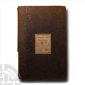
Numismatic Books - Whelan - The Numismatic Atlas of the Roman EmpireTimeLine Auctions Ltd.4.6(183)See Sold PriceMar 09, 2024
Numismatic Books - Lelewel - Numismatique du Moyen-AgeTimeLine Auctions Ltd.4.6(183)See Sold PriceMar 09, 2024
Numismatic Books - De La Tour - Atlas de Monnaies GauloisesTimeLine Auctions Ltd.4.6(183)See Sold PriceMar 09, 2024
Numismatic Books - Whelan - The Numismatic Atlas of the Roman EmpireTimeLine Auctions Ltd.4.6(183)See Sold PriceMar 09, 2024
Large Assortment of Railroad Items - Insulators, Globes, Hand Bell, Posters, Maps, Timetables,Rail & Road Auctions4.6(165)See Sold PriceMar 07, 2024
Arrowsmith & Lewis - Map of the United StatesTrillium Antique Prints & Rare Books4.5(32)See Sold PriceFeb 24, 2024
Putnam - First Map of the State of Ohio by Rufus PutnamTrillium Antique Prints & Rare Books4.5(32)See Sold PriceFeb 24, 2024
Carey, pub. 1796 - Map of KentuckyTrillium Antique Prints & Rare Books4.5(32)See Sold PriceFeb 24, 2024
Carey, pub. 1796 - Map of the Tennassee State formerly part of North Carolina (Tennessee)Trillium Antique Prints & Rare Books4.5(32)See Sold PriceFeb 24, 2024
De Jode, Rare, pub. 1593 - Map of the Middle East, Eastern Asia (Primae Partis Asiae accurataTrillium Antique Prints & Rare Books4.5(32)See Sold PriceFeb 24, 2024
De Jode, Rare, pub. 1593 - Map of Africa (Africae Vera Forma, et Situs)Trillium Antique Prints & Rare Books4.5(32)See Sold PriceFeb 24, 2024