ATLAS of ANTIENT GEOGRAPHY by SAMUEL BUTLER 1843John McInnis Auctioneers,LLC4.6(504)See Sold PriceFeb 24, 2024
18TH C. ANTIQUE MAP: FRENCH & INDIAN WAR, FRAMEDThomaston Place Auction Galleries4.4(389)See Sold PriceFeb 24, 2024
Rand McNally Railroad Map Cabinet w/ 21 Railroad MapsRail & Road Auctions4.6(165)See Sold PriceMar 08, 2024
Keith Haring - Ink on New York Map, Best Buddies, Inscribed, Signed, and DatedSapphire Auction Gallery4.1(67)See Sold PriceMar 02, 2024
LATE 17TH C. FRENCH MAP OF THE NEW WORLD BY ALEXIS-HUBERT JAILLOT (1632-1712)Thomaston Place Auction Galleries4.4(389)See Sold PriceFeb 24, 2024
Central Railroad of New Jersey Map of Sandy Hook Route-ca. 1903JM Hobby Supply and Railroad Artifact Auctions4.4(126)See Sold PriceFeb 24, 2024
Lot of Six Mixed Atlas Box Cars-HO Scale-New in BoxJM Hobby Supply and Railroad Artifact Auctions4.4(126)See Sold PriceFeb 25, 2024
Rand McNally/Santa Fe Railroad Map of Iowa-1912JM Hobby Supply and Railroad Artifact Auctions4.4(126)See Sold PriceFeb 24, 2024
NICOLAES VISSCHER (NETHERLANDS, 1618-1709) MAP OF THE NEW WORLDThomaston Place Auction Galleries4.4(389)See Sold PriceFeb 24, 2024
17TH C. WORLD MAP BY NICOLAES VISSCHER (NETHERLANDS, 1618-1709)Thomaston Place Auction Galleries4.4(389)See Sold PriceFeb 24, 2024
Lot of Six Mixed Atlas Cabooses-HO Scale-New in BoxJM Hobby Supply and Railroad Artifact Auctions4.4(126)See Sold PriceFeb 25, 2024
SoldNetherlands 1747 Map of Holland, Utrecht"A New & Exact Map of the Provinces of Holland, Utrecht, Gelderland, Zeeland, Dutch Flanders and Dutch Brabant" Copper Engraved Map Published 1732-85, London for "The London Magazine" Folds as issued.See Sold Price
Netherlands 1747 Map. A Plan of Maestricht. HollandCopper Engraved Map Published 1732-85, London for "The London Magazine" Paper Size: 8 x 5 inch (20 x 13cm) Good ConditionSee Sold Price
Antique Map Print - John Cary - United Provinces - Holland, Zealand, UtrechtAn extremely attractive example of John Cary's 1799 map of the Netherlands. Consists of the provinces of Holland, Zealand, Utrecht, Gelders, Over Yssel, Friesland, and Groningen, as well as Drent, DutSee Sold Price
Laurie & Whittle, Map of Holland & the NetherlandsLaurie & Whittle, Map of Holland and the Netherlands, 1794, titled, "Seat of War in the Seven United Provinces, Comprehending Holland, Zeeland, Utrecht, Gelders, Over-Yssel, Frieseland and Groningen;See Sold Price
SoldNetherlands 1747 Antique Map. Bergen-Op-Zoom"A New and Exact Plan of the Town and Fortifications of Bergen-Op-Zoom" Copper Engraved Map Published 1732-85, London for "The London Magazine" Folds as issued. Paper Size: 10.5 x 8 inch (27 x 20cm) GSee Sold Price
SoldTallis, John (Pub) 1852 Map. Holland. NetherlandsSteel Engraved Map with Original Outline Hand Color Published 1852-56 by John Tallis, London for "The Universal Pronouncing Dictionary" by Thomas Wright. Drawn & Engraved by John Rapkin. Centre fold aSee Sold Price
SoldLochhead (Pub) 1811 Rare Map. Netherlands Holland"The Severn United Provinces with the Dutch and Austrian Netherlands" Copper Engraved Map Published 1811 by William Lochhead, Berwick for "Modern Geography: And a Compendious General Gazetteer" Rare.See Sold Price
Sidney Hall: Antique Map of Holland, 1856Title/Content of Map: 'Holland' Netherlands. Railways. old antique map plan chart Date Printed: 1856 Image Size: Approx 40.5 x 29.0cm, 15.75 x 11.25 inches (Large) Type: Antique atlas map with originaSee Sold Price
Holland Hollandt Comitatus Utrecht. Mercator. 1585-1595Reserve Reduced! Title/Content of Map: Holland Hollandt Comitatus Utrecht. Mercator. 1585-1595 Date Printed: 1585/1595 Cartographer: Mercator Material/Medium: engraving Size: 52 x 61 cm. Provenance: tSee Sold Price
Tallis/Rapkin: Map of Netherlands/Holland, 1851Title/Content of Map: Netherlands. 'Holland' Vignettes: Rotterdam; On the Dort; Dutch Peasants DATE PRINTED: 1851 IMAGE SIZE: Approx 36.5 x 26.5cm, 14.5 x 10.25 inches (Large) TYPE: Antique engraved mSee Sold Price
SoldNetherlands, Belgium, Low Countries 1747 Map"A Correct Map of the Low Countries" Copper Engraved Map Published 1732-85, London for "The London Magazine" Folds as issued. Paper Size: 11 x 9 inch (28 x 23cm) Good ConditionSee Sold Price
SoldHall: Antique Map of Holland. Netherlands. 1856TITLE/CONTENT OF MAP: 'Holland' DATE PRINTED: 1856 IMAGE SIZE: Approx 40.5 x 29.0cm, 15.75 x 11.25 inches (Large) TYPE: Antique atlas map with original hand colouring / coloring CONDITION: Good; suitaSee Sold Price
Hall: Antique Map of Netherlands, Holland & BelgiumTITLE/CONTENT OF MAP: 'Netherlands, now divided into Holland and Belgium' DATE PRINTED: 1856 IMAGE SIZE: Approx 40.0 x 28.5cm, 15.75 x 11.25 inches (Large) TYPE: Antique atlas map with original hand cSee Sold Price
Descrittione dell' Isola d'Hollanda. PORCACCHI. Holland Netherlands 1620 mapTITLE/CONTENT OF MAP: 'Descrittione dell' Isola d'Hollanda [Description of the island of Holland]' The map depicts the Dutch "island" / province of Holland. The map is orientated towards the north. DASee Sold Price
Descrittione dell' Isola d'Hollanda. PORCACCHI. Holland Netherlands 1590 mapTITLE/CONTENT OF MAP: Descrittione dell' Isola d'Hollanda [Description of the island of Holland] The map depicts the Dutch "island" / province of Holland. The map is orientated towards the north. DATESee Sold Price
Sold1887 1ed HOLLAND Pictures Netherlands Dutch MAP1887 1ed HOLLAND Pictures Netherlands Dutch MAP Illustrated Landscape Portraits A rare 19th-century illustrated book of the history of Holland. This work includes 133 in-text and full-page illustratioSee Sold Price
Hall: Antique Map of the Netherlands, 1856TITLE/CONTENT OF MAP: 'Netherlands, now divided into Holland and Belgium' Benelux DATE PRINTED: 1856 IMAGE SIZE: Approx 40.0 x 28.5cm, 15.75 x 11.25 inches (Large) TYPE: Antique atlas map with originaSee Sold Price
SoldGroup of 4 mapsGroup of 4 maps 1). Johann Baptist Homanno- ''Ducatus Brabantiae Nova Tabula''; 2). John Cary- ''A New Map of United Provinces, Comprehending Holland, Zealand, Utrecht, Gelders, Over Yssel, FrieslandSee Sold Price
Map of Holland and Belgium. Netherlands. 1835.Print of hand colored steel engraving titled „Hollande et Belgique“.Author C. V. Monin.Engraved by unknown.From the „Atlas Universel de Geography“ by C. V. Monin. Parsi. 1835.Belgium officiallSee Sold Price
Map of the Province of Utrecht, HollandFramed paper engraving. "Vltraiectvm Dominivm", top right a cartouche with the title. To the right is a standing surveyor with a distant bar in his hand that indicates a scale in Dutch miles. MeasuresSee Sold Price
SoldMap of the Province of Utrecht, HollandFramed paper engraving. "Vltraiectvm Dominivm", top right a cartouche with the title. To the right is a standing surveyor with a distant bar in his hand that indicates a scale in Dutch miles. MeasuresSee Sold Price
SoldBarlow 1807 Pair of Maps of The Netherlands, Holland"The Severn United Provinces" and "Netherlands from the best Authorities" Copper Engraved Map Published 1807 by Brightly & Kinnersley, Bungay, England for "A General View of the World, Geographical, HSee Sold Price
Map of Holland and Belgium. Netherlands. 1835.Print of hand colored steel engraving titled „Hollande et Belgique“.Author C. V. Monin.Engraved by unknown.From the „Atlas Universel de Geography“ by C. V. Monin. Parsi. 1835.Belgium officiallSee Sold Price
Scarce 1816 map of Holland and The Netherlands“Holland or the Seven United Provinces and the Netherlands” from the very scarce 1816 edition of Mathew Carey’s General Atlas. Highly detailed with roads, lakes, islands, bays, coastSee Sold Price
NICOLAES VISSCHER (NETHERLANDS, 1618-1709) MAP OF THE NEW WORLDThomaston Place Auction Galleries4.4(389)See Sold PriceFeb 24, 2024
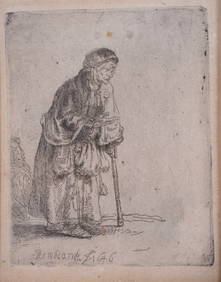
Rembrandt "A Beggar Woman Leaning on a Stick" EtchingNapoleon's Fine Art4.4(75)See Sold PriceFeb 25, 2024
Carte du Golfe de Guinée'. Gulf of Guinea. Nigeria & Cameroon. BELLIN 1747 mapJasper524.5(9.8k)See Sold PriceFeb 28, 2024
Coste Occidentale d’Afrique'. Bay of Arguin, Mauritania. BELLIN/SCHLEY 1747 mapJasper524.5(9.8k)See Sold PriceFeb 28, 2024
Plan du Portendic, appellé aussi…' Portendick Mauritania BELLIN/SCHLEY 1747 mapJasper524.5(9.8k)See Sold PriceFeb 28, 2024
Partie de la Coste de Guinée' Sierra Leone Liberia coast BELLIN/SCHLEY 1747 mapJasper524.5(9.8k)See Sold PriceFeb 28, 2024
Partie de la Coste de Guinée'. Sierra Leone & Liberia coast. BELLIN 1747 mapJasper524.5(9.8k)See Sold PriceFeb 28, 2024
Coste Orientale d’Afrique'. South Africa Mozambique BELLIN/SCHLEY 1747 mapJasper524.5(9.8k)See Sold PriceFeb 28, 2024
Coste d’Afrique…' Guinea-Bissau & Bissagos archipelago. BELLIN/SCHLEY 1747 mapJasper524.5(9.8k)See Sold PriceFeb 28, 2024
Suite de la Coste de Guinée'. Ghana Togo Benin coast. Whidah. BELLIN 1747 mapJasper524.5(9.8k)See Sold PriceFeb 28, 2024
Netherlands/Holland Silver Lion Daalder VF (Random Years)3 Kings Auction4.2(197)See Sold PriceFeb 26, 2024
1739 Netherlands Utrecht Silver 1 Ducaton AU-55 NGCGolden Air Auctions4.4(261)See Sold PriceFeb 24, 2024
1979 Netherlands Utrecht Gold 50 Unie Daalders Proof (400 Years)Golden Air Auctions4.4(261)See Sold PriceFeb 25, 2024