SoldNeele (S. J.) maps of the 4 HemispheresNeele (S. J.) maps of the 4 Hemispheresthe set of 4 from Pinkerton's Modern Atlas, engraved circular maps, with full hand-colouring, each c.555 x 765mm., central vertical folds, trimmed withinSee Sold Price
SoldNeele, J. 1836 Antique World Hemisphere MapSteel Engraved Map Published 1836, London for "The Universal Preceptor; or, General Grammar..." by the Rev. David Blair. Engraved by J. Neele. Folds as issued. Paper Size: 10.5 x 5.5 inch (27 x 14cm)See Sold Price
SoldNeele, J. 1834 Antique World Hemisphere MapSteel Engraved Map Published 1834, London for "The Universal Preceptor; or, General Grammar..." by the Rev. David Blair. Engraved by J. Neele. Folds as issued. Paper Size: 10.5 x 5.5 inch (27 x 14cm)See Sold Price
Thomas Jefferson's Notes on VirginiaObservations sur la Virginie. Thomas Jefferson (1743-1826). Paris: Barrois, 1786. 8vo (7 3/4 x 5 inches). Half-title, folding letterpress table. Fine engraved folding map by S.J. Neele. Early 20th-cenSee Sold Price
Reinecke: Antique Map of the Western Hemisphere, 1804Title/Content of Map: Western Hemisphere Rare Map Date Printed: 1804 Cartographer: J.C. M. Reinecke Material/Medium: Paper Size: 27" x 23 3/4" Rare map of the Western Hemisphere. Unsusal aspects incluSee Sold Price
Homann: Atlas Title Page with Northern Hemisphere MapMap Title: Neuer Atlas [title page]. Cartographer: J.B. Homann Place / Date: Nurnberg / 1712 Size: 12" x 20 3/4" (overall sheet), 5 1/4" x 4" (map). Condition: type in black and red, map b&w; light ovSee Sold Price
Sold(MISCELLANEOUS MAPS.) Group of 4 engraved maps.(MISCELLANEOUS MAPS.) Group of 4 engraved maps. European makers, 18th-19th centuries. - Vp, vd J. Hardy (for the Gentleman's Magazine). A New Projection of the Eastern Hemisphere of the Earth on a PlaSee Sold Price
SoldCary, John. A New Map of America. 1806.[Americas/ Western Hemisphere] Cary, John. “A New Map of America From the Latest Authorities.” London, J. Cary, 1806. Engraved map. 20 1/2” x 18 1/4”. Framed: 30” x 27 1/See Sold Price
SoldThomson: Antique Map of The Americas, 1816Map: The Americas Cartographer: J. Thomson Place & Date: Edinburgh / 1816 Size: 20 1/2" x 18 1/4" Condition: outline color; overall age toning The elegant Western Hemisphere map from Thomson's New GenSee Sold Price
Western Hemisphere by Reinecke Rare Map, 1804Title/Content of Map: Western Hemisphere by Reinecke Rare Map * Date Printed: 1804 Cartographer: J.C.M. Reinecke Size: 27" x 23 3/4" Material/Medium: Paper Provenance: New York Published in Weimar GerSee Sold Price
Reinecke: Antique Rare Map of Western Hemisphere, 1804Title/Content of Map: Western Hemisphere Rare Map Reinecke Date Printed: 1804 Cartographer: J.C.M. Reinecke Material/Medium: Paper Size: 27" x 23 3/4" Published in Weimar Germany. Rare map of the WestSee Sold Price
Western Hemisphere by Reinecke *RARE*Title/Content of Map: Western Hemisphere by Reinecke *RARE* Date Printed: 1804 Cartographer: J.C. M. Reinecke Material/Medium: Paper Size: 27" x 23 3/4" Provenance: New York Rare Map of the Western HeSee Sold Price
SoldCook (Capt. J.) Voyages...Cook (Captain James) [First Voyage] Hawkesworth (John) Relation des Voyages..., 4 vol., 52 engraved plates and maps, 1774; [Second Voyage] Voyage dans l'Hemisphere Austral et autour du Monde,See Sold Price
SoldBellin: Antique Map of South Pole & Southern HemisphereTitle/Content of Map: South Pole & Southern Hemisphere Date Printed: 1740-70's Cartographer: J.N. Bellin & J.F. La Harpe Material/Medium: Paper Size: 22 1/4" x 22 1/4" Copperplate engraved. From the 'See Sold Price
Hawkesworth, J. Voyages in Southern Hemisphere (book)Hawkesworth, John An Account of the voyages Discoveries in the Southern Hemisphere, 2nd Edition Vol I-III (book) 1773 Copperplate engraving; uncoloured Printed area: 29.8 x 24 cm; 11.7 x 9.4 in CooksSee Sold Price
World in double hemisphereTitle: World in double hemisphere Date/Period: 1861 Materials: Steel engraved. Size: 27x17 3/4” By A. J. Johnson & J. H Colton. From "Johnson's New Illustrated Family Atlas' published in New York. SSee Sold Price
Evans Celestial of Southern HemisphereSouthern Circumpolar Map for each Month in the Year, Pl. VII. W. G. Evans. Hand-colored engraving. Hartford: F. J. Huntington, 1835. 16 1/2 x 14 1/4 inches sheetSee Sold Price
SoldGerman school atlas, 1818. 35 (of 36) handcol map[School Atlas]. Neuester Schul=Atlass. Augsburg: Joh. Walch, 1818. Oblong 4to. 35 (of 36) hand-colored maps: 4 hemisphere maps, 25 (of 26) maps of European countries/regions, Egypt, Indonesia, and 5 NSee Sold Price
SoldCa.1860's North American Alvin J. Johnson Maps (4)Four Circa 1860's North American Maps by Alvin J. Johnson. 1) Johnson's Arkansas, Mississippi and Louisiana map. 2) Johnson's Kentucky and Tennessee map. 3) Johnson's Georgia and Alabama map. 4) JohnsSee Sold Price
Solda small, mixed, group of world mapsWorld.- a small, mixed, group of world maps,4 double-hemisphere maps, and 2 on Mercator's projection, for, by, or after Thomas Bowen, Assheton, Harrison, Russell and others, engraved and lithoSee Sold Price
SoldWALCH, Johann (1757–1816). A group of 4WALCH, Johann (1757–1816). A group of 4 hemisphere maps. Augsburg, 1787. Each 203 x 260 mm. Hand–colored engravings of the Northern, Southern, Western, and Eastern hemispheres. (Some margiSee Sold Price
Sold4 maps: Colonial US, Maryland, DC, Railroads[Railroads/MD/DC] 4 Maps. ++ J.G. Langdon. MAP OF THE DISTRICT OF COLUMBIA 1901… FOR THE PREPARATION OF A PLAN FOR THE IMPROVEMENT OF THE PARK SYSTEM OF THE DISTRICT OF COLUMBIA. NO. D-99. Balt: A.See Sold Price
SoldAmericas.- California.- Shelvocke (Captain George) AAmericas.- California.- Shelvocke (Capt. George) A Voyage round the World by the Way of the Great South Sea, first edition, engraved title-vignette, folding engraved twin-hemisphere map, 4 engraved plSee Sold Price
SoldGROUP OF 5 ASSORTED MAPS1892 MAP OF BAHAMA ISLANDS BY TUNISAN,1850 MAO OF PERSIA AND ARABIA BY THOS. COPERTHWAIT,1802 UNITED STATES MAP BY ALEXANDRE BLONDEAU,1855 WESTERN HEMISPHERE MAP BY J.H. COLOTN AND AN 1836 MAP OF SOUTSee Sold Price
MARTINET / DE VRIES Catechism of Nature 4 Vol. Set c1788 Engravings Rare!Luis Porretta Fine Arts4.3(10)See Sold PriceMar 02, 2024
COVENS & MORTIER 1745 MAP OF THE GLOBEThomaston Place Auction Galleries4.4(393)See Sold PriceFeb 24, 2024
19thc Colton Map, Comparitive Size of Lakes & IslandsConnoisseur Auctions3.9(336)See Sold PriceFeb 24, 2024
Pair of Early Railroad Maps - 1874 Delaware, Lackawanna & Western and 1876 Pennsylvania RailroadRail & Road Auctions4.6(165)See Sold PriceMar 07, 2024
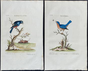
Edwards & Seligmann - 4 Bird EngravingsTrillium Antique Prints & Rare Books4.5(32)See Sold PriceFeb 24, 2024
1736 LARGE MAP OF SILESIA POLAND OPPAVIENSIS antique 25 by 34 3/4"Jasper524.5(9.9k)See Sold PriceFeb 27, 2024
1736 LARGE MAP OF SILESIA POLAND KARNOVIENSIS antique 25 x 4 3/4" Duchy of KrnovJasper524.5(9.9k)See Sold PriceFeb 27, 2024
Map of Mexico, Central America, New Grenada, Venzuela and the West IndiesJasper524.5(9.9k)See Sold PriceFeb 27, 2024
1764 Bellin Map of Fort Louis Area of Guadeloupe -- Environs du Fort Louis de la GuadeloupeJasper524.5(9.9k)See Sold PriceFeb 27, 2024
Tour of the Dutch East Indies, with exceptional platesPBA Galleries4.7(385)See Sold PriceMar 07, 2024
Roseate Spoonbill, Audubon, Royal Octavo hand-colored lithographPBA Galleries4.7(385)See Sold PriceMar 07, 2024
Clarke & Neele 1815 Map. Europe - Recent Political ChangesAlbion Auctions4.7(341)See Sold PriceMar 01, 2024
THE WHOLE CHRONICLE OF POLYBIUS ANCIENT IN ENGLISH, 1756NY Elizabeth 4.2(86)See Sold PriceMar 03, 2024
Carl J. Sundevall (1801 - 1875) Set of 4 Bird Prints - Dove - Woodpecker - DuckProverde Auctions4.3(3)See Sold PriceFeb 28, 2024
Set of 4 Maps - Netherlands - Seven United Provinces - Germany - Sweden, Denmark, Norway, FinlandProverde Auctions4.3(3)See Sold PriceFeb 28, 2024
TWO ANTIQUE JEWISH NATIONAL FUND CHARITY BOXES. The first one made in Berlin c. 1920J. Greenstein & Co., Inc.4.2(55)See Sold PriceApr 16, 2024