ATLAS of ANTIENT GEOGRAPHY by SAMUEL BUTLER 1843John McInnis Auctioneers,LLC4.5(505)See Sold PriceFeb 24, 2024
18TH C. ANTIQUE MAP: FRENCH & INDIAN WAR, FRAMEDThomaston Place Auction Galleries4.4(393)See Sold PriceFeb 24, 2024
Rand McNally Railroad Map Cabinet w/ 21 Railroad MapsRail & Road Auctions4.6(165)See Sold PriceMar 08, 2024
Keith Haring - Ink on New York Map, Best Buddies, Inscribed, Signed, and DatedSapphire Auction Gallery4(67)See Sold PriceMar 02, 2024
LATE 17TH C. FRENCH MAP OF THE NEW WORLD BY ALEXIS-HUBERT JAILLOT (1632-1712)Thomaston Place Auction Galleries4.4(393)See Sold PriceFeb 24, 2024
Central Railroad of New Jersey Map of Sandy Hook Route-ca. 1903JM Hobby Supply and Railroad Artifact Auctions4.4(127)See Sold PriceFeb 24, 2024
Lot of Six Mixed Atlas Box Cars-HO Scale-New in BoxJM Hobby Supply and Railroad Artifact Auctions4.4(127)See Sold PriceFeb 25, 2024
Rand McNally/Santa Fe Railroad Map of Iowa-1912JM Hobby Supply and Railroad Artifact Auctions4.4(127)See Sold PriceFeb 24, 2024
NICOLAES VISSCHER (NETHERLANDS, 1618-1709) MAP OF THE NEW WORLDThomaston Place Auction Galleries4.4(393)See Sold PriceFeb 24, 2024
17TH C. WORLD MAP BY NICOLAES VISSCHER (NETHERLANDS, 1618-1709)Thomaston Place Auction Galleries4.4(393)See Sold PriceFeb 24, 2024
Lot of Six Mixed Atlas Cabooses-HO Scale-New in BoxJM Hobby Supply and Railroad Artifact Auctions4.4(127)See Sold PriceFeb 25, 2024
SoldMitchell, Thomas, Cowperthwait: Map of Hindostan, 1851Title: Map of Hindostan by Mitchell, Thomas, Cowperthwait Date: 1851 Dimensions: 14 x 17 Medium: Hand Colored Lithograph Please note that this lot has a confidential reserve. When you leave a bid inSee Sold Price
SoldMitchell, Thomas, Cowperthwait: Map of China, 1851Title: Map of China by Mitchell, Thomas, Cowperthwait Date: 1851 Dimensions: 17 x 14 Medium: Hand Colored Lithograph Please note that this lot has a confidential reserve. When you leave a bid in advanSee Sold Price
SoldMitchell, Thomas, Cowperthwait: Map of Asia, 1851Title: Map of Asia by Mitchell, Thomas, Cowperthwait Date: 1851 Dimensions: 17 x 14 Medium: Hand Colored Lithograph Please note that this lot has a confidential reserve. When you leave a bid in advancSee Sold Price
Mitchell, Cowperthwait: Antique Map of Naples, 1851Title: Map of The Kingdom of Naples by Mitchell, Thomas Cowperthwait, Date: 1851 Dimensions (inches): 14 x 17 Medium: Hand Colored Lithograph Condition: Good Condition Samuel Augustus Mitchell (1790-1See Sold Price
SoldMitchell & Cowperthwait: Antique Map of Naples, 1851Title: Map of the Kingdom of Naples by Mitchell & Thomas Cowperthwait Date: 1851 Medium: Hand Colored Lithograph Dimensions (in.): 13.5 x 17 Samuel Augustus Mitchell (1790-1860) was an American geograSee Sold Price
Mitchell / Cowperthwait: South America, 1851Title/Content of Map: Mitchell / Cowperthwait: South America, 1851 Date Printed: 1851, Philadelphia Cartographer: Mitchell / Thomas, Cowperthwait & Co. Size: 13" x 15 3/4" The attractive, highly detaiSee Sold Price
Mitchell / Cowperthwait: South America, 1851Title/Content of Map: Mitchell / Cowperthwait: South America, 1851 Date Printed: 1851, Philadelphia Cartographer: Mitchell / Thomas, Cowperthwait & Co. Size: 13" x 15 3/4" The attractive, highly detaiSee Sold Price
SoldA New Map Of Virginia, 1851 folding map, color.[Virginia]. A New Map Of Virginia With its Canals, Roads & Distances from place to place, along the Stage & Steam Boat Routes. Phila: Thomas Cowperthwait/ Samuel Augustus Mitchell, 1851. 10 1/8 x 12 1See Sold Price
Cowperthwait, Mitchell: Map of Denmark, 1851Title: Map of Denmark by Thomas Cowperthwait, Mitchell Date: 1851 Dimensions (inches): 14 x 17 Medium: Hand Colored Lithograph Condition: Good Condition Please note that this lot has a confidential reSee Sold Price
Sold* MITCHELL, Samuel Augustus (1792-1868). A New* MITCHELL, Samuel Augustus (1792-1868). A New Universal Atlas. Philadelphia: Thomas Cowperthwait, 1851. 4to (432 x 351 mm). Chromolithographic title-page, chromolithographic contents leaf, 74 lithogrSee Sold Price
SoldMitchell, Thomas, Cowperthwait: Map of Turkey in AsiaTitle: Map of Turkey in Asia by Mitchell, Thomas, Cowperthwait Date: 1851 Dimensions: 17 x 14 Medium: Hand Colored Lithograph Please note that this lot has a confidential reserve. When you leave a bidSee Sold Price
SoldMitchell, Thomas: Antique Map of Hindostan, 1854Title: Map of Hindostan by Mitchell, Thomas,DeSilver Date: 1854 Dimensions: 14 x 17 Medium: Hand Colored Lithograph Samuel Augustus Mitchell (1790-1860) was an American geographer born in ConnecticutSee Sold Price
SoldMitchell, Thomas: Antique Map of Sardinia, 1851Title: Map of the Kingdom of Sardinia by Mitchell, Thomas, Cowperthwait Date: 1851 Dimensions (inches): 17 x 14 Medium: Hand Colored Lithograph Condition: Good Condition Samuel Augustus Mitchell (1790See Sold Price
SoldMitchell, Thomas: Antique Map of Germany, 1851Title: Map of Germany Mitchell, Thomas, Cowperthwait Date: 1851 Dimensions (inches): 14 x 17 Medium: Hand Colored Lithograph Condition: Good Condition Samuel Augustus Mitchell (1790-1860) was an AmeriSee Sold Price
SoldMITCHELL. Pocket map of Illinois.MAP - MITCHELL, S. Augustus; and Thomas COWPERTHWAIT. Map of the State of Illinois.Philadelphia: Cowperthwait, [c. 1840]. Hand-colored engraved folding pocket map (405x340 mm). Folds into pSee Sold Price
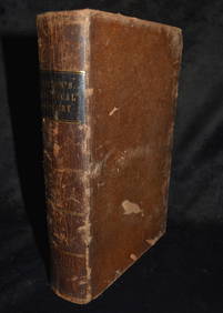
Sold1 vol. (Mitchell's Universal Atlas.) New Universa1 vol. (Mitchell's Universal Atlas.) New Universal Atlas. Philadelphia: Thomas Cowperthwait, 1851. Folio, orig. 1/4 morocco & bds., morocco cover label; worn & rubbed, spine defective, front cover detSee Sold Price
Mitchell, Thomas, Desilver: Map of Greece, 1854Title: Map of Greece by Mitchell, Thomas Cowperthwait, Desilver Date: 1854 Dimensions (inches): 17 x 14 Medium: Hand Colored Lithograph Condition: Good Condition Please note that this lot has a confidSee Sold Price
SoldMitchell, Desilver: Map of Turkey In Europe, 1854Title: Map of Turkey In Europe by Mitchell, Thomas Cowperthwait, Desilver Date: 1854 Dimensions (inches): 14 x 17 Medium: Hand Colored Lithograph Condition: Good Condition Please note that this lot haSee Sold Price
SoldMitchell Cowperthwait: Map of Russia in Asia & TartaryTitle: Map of Russia in Asia and Tartary By Mitchell, Thomas, and Cowperthwait Date: 1851 Dimensions: 17 x 14 Medium: Hand Colored Lithograph Please note that this lot has a confidential reserve. WhenSee Sold Price
Mitchell, Desilver: Map of The Kingdom of Naples, 1854Title: Map of The Kingdom of Naples by Mitchell, Thomas Cowperthwait, Desilver Date: 1854 Dimensions (inches): 14 x 17 Medium: Hand Colored Lithograph Condition: Good Condition Please note that this lSee Sold Price
Sold1853 No. 4 United States, BurgessInteresting map of the Atlantic states from Mitchell’s 1853 School Atlas published by Thomas, Cowperthwait & Co. The map is copyrighted by Daniel Burgess. In this map West Virginia is still part ofSee Sold Price
Thomas, Cowperthwait & Co.: South America, 1851Title/Content of Map: Thomas, Cowperthwait & Co.: South America, 1851 Date Printed: 1851/Philadelphia Cartographer: Thomas, Cowperthwait & Co. Size: 13" x 15 3/4" The attractive, highly detailed map oSee Sold Price
New Map of Kentucky With Its Roads & Distances fromTitle: New Map of Kentucky With Its Roads & Distances from Place to Place Along the Stage & Steamboat Routes Publication Date: c1850 Cartographer: S. Augustus Mitchell Publisher: THOMAS, COWPERTHWAITSee Sold Price
City of Washington.Title: City of Washington. Publication Date: 1855 Cartographer: S. Augustus Mitchell Publisher: Thomas Cowperthwait & Co Dimensions: 1.5 X 15.5 Additional Information: Reference tables for public builSee Sold Price
HENRY ALKEN The Quorn Hunt Original Aquatint ca1840 Equestrian FramedLuis Porretta Fine Arts4.3(10)See Sold PriceMar 02, 2024
1849 Mitchell School ATLAS 24 MAPS America Holy Land France Africa Egypt AsiaSchilb Antiquarian Rare Books4.8(428)See Sold PriceMar 31, 2024
1842 Practical Surgery with One Hundred and Fifty Engravings on WoodNorth American Artifact Auctions4.7(198)See Sold PriceApr 20, 2024
Mitchell - Map of the City of Washington (Washington, DC)Trillium Antique Prints & Rare Books4.5(32)See Sold PriceFeb 24, 2024
NORTHERN AFRICA. Morocco Tunisia Algeria. Caravan routes. RAPKIN/TALLIS 1851 mapJasper524.5(9.9k)See Sold PriceFeb 28, 2024
WEST AFRICA I Explorers' routes Senegal Ashanti Ivory Gold Coast. SDUK 1851 mapJasper524.5(9.9k)See Sold PriceFeb 28, 2024
WEST AFRICA II. NIGERIA. Bight of Benin-Lake Chad. Yariba Houssa. SDUK 1851 mapJasper524.5(9.9k)See Sold PriceFeb 28, 2024
NORTH AFRICA OF BABRBARY V Parts of Tripoli & Egypt. Libya Tribes. SDUK 1851 mapJasper524.5(9.9k)See Sold PriceFeb 28, 2024
AFRICA. Shows Mountains of Kong/the Moon. Caravan routes. RAPKIN/TALLIS 1851 mapJasper524.5(9.9k)See Sold PriceFeb 28, 2024
WESTERN AFRICA.Kong Mountains.Caravan routes.Slave Coast.TALLIS/RAPKIN 1851 mapJasper524.5(9.9k)See Sold PriceFeb 28, 2024
NORTHERN AFRICA. Morocco Tunisia Algeria. Caravan routes.TALLIS/RAPKIN 1851 mapJasper524.5(9.9k)See Sold PriceFeb 28, 2024
NORTHERN AFRICA. Morocco Tunisia Algeria. Caravan routes. RAPKIN/TALLIS 1851 mapJasper524.5(9.9k)See Sold PriceFeb 28, 2024
MITCHELL THOMAS: (1892-1962)International Autograph Auctions Europe S.L.4.5(52)See Sold PriceMar 12, 2024
Mary Jane Thomas Stokes - Map of Lighthouses of the Chesapeake Bay. Past and PresentProverde Auctions4.3(3)See Sold PriceFeb 28, 2024