ATLAS of ANTIENT GEOGRAPHY by SAMUEL BUTLER 1843John McInnis Auctioneers,LLC4.6(504)See Sold PriceFeb 24, 2024
18TH C. ANTIQUE MAP: FRENCH & INDIAN WAR, FRAMEDThomaston Place Auction Galleries4.4(389)See Sold PriceFeb 24, 2024
Rand McNally Railroad Map Cabinet w/ 21 Railroad MapsRail & Road Auctions4.6(165)See Sold PriceMar 08, 2024
Keith Haring - Ink on New York Map, Best Buddies, Inscribed, Signed, and DatedSapphire Auction Gallery4.1(67)See Sold PriceMar 02, 2024
LATE 17TH C. FRENCH MAP OF THE NEW WORLD BY ALEXIS-HUBERT JAILLOT (1632-1712)Thomaston Place Auction Galleries4.4(389)See Sold PriceFeb 24, 2024
Central Railroad of New Jersey Map of Sandy Hook Route-ca. 1903JM Hobby Supply and Railroad Artifact Auctions4.4(126)See Sold PriceFeb 24, 2024
Lot of Six Mixed Atlas Box Cars-HO Scale-New in BoxJM Hobby Supply and Railroad Artifact Auctions4.4(126)See Sold PriceFeb 25, 2024
Rand McNally/Santa Fe Railroad Map of Iowa-1912JM Hobby Supply and Railroad Artifact Auctions4.4(126)See Sold PriceFeb 24, 2024
NICOLAES VISSCHER (NETHERLANDS, 1618-1709) MAP OF THE NEW WORLDThomaston Place Auction Galleries4.4(389)See Sold PriceFeb 24, 2024
17TH C. WORLD MAP BY NICOLAES VISSCHER (NETHERLANDS, 1618-1709)Thomaston Place Auction Galleries4.4(389)See Sold PriceFeb 24, 2024
Lot of Six Mixed Atlas Cabooses-HO Scale-New in BoxJM Hobby Supply and Railroad Artifact Auctions4.4(126)See Sold PriceFeb 25, 2024
Mitchell: Antique Map of Africa [verso] Oceania, 1878Title/Content of Map: 1878 Mitchell map of Africa [verso] Oceania / Australia -- Map of Africa Showing its Most Recent Discoveries [verso] Map of Oceanica, Exhibiting it's Various Divisions Island GroSee Sold Price
Mitchell: Antique Map of Africa verso Oceania/AustraliaTitle/Content of Map: 1878 Mitchell map of Africa [verso] Oceania / Australia -- Map of Africa Showing its Most Recent Discoveries [verso] Map of Oceanica, Exhibiting it's Various Divisions Island GroSee Sold Price
Sold1858 Mitchell Map of Africa [verso] Oceania and HawaiiTitle/Content: 1858 Mitchell Map of Africa [verso] Oceania and Hawaii -- No. 28 Map of Africa [verso] No. 31 Map of Oceania - with Sandwitch Island Inset Cartographer: S Mitchell Year/Place: 1858, PhiSee Sold Price
Sold1876 Mitchell map of Africa [verso] Oceania / AustraliaTitle/Content of Map: 1876 Mitchell map of Africa [verso] Oceania / Australia -- Map of Africa Showing its Most Recent Discoveries [verso] Map of Oceanica, Exhibiting it's Various Divisions Island GroSee Sold Price
Sold1869 Mitchell Map of Africa [verso] Oceania -- XLTitle: 1869 Mitchell Map of Africa [verso] Oceania -- XL Africa [verso] XLIII Oceania Including Malaysia, Australia and Polynesia Cartographer: S Mithchell Year / Place: 1869, Philadelphia Map DimensiSee Sold Price
1858 Mitchell Map of Africa [verso] Oceania and HawaiiTitle/Content of Map: 1858 Mitchell Map of Africa [verso] Oceania and Hawaii -- No. 28 Map of Africa [verso] No. 31 Map of Oceania - with Sandwitch Island Inset Date: 1858, PhiladelphiaCartographer: SSee Sold Price
1858 Mitchell Map of Africa [verso] Oceania and HawaiiTitle: 1858 Mitchell Map of Africa [verso] Oceania and Hawaii -- No. 28 Map of Africa [verso] No. 31 Map of Oceania - with Sandwitch Island Inset Date: 1858, Philadelphia Cartographer: S Mitchell SizeSee Sold Price
1876 Mitchell map of Africa [verso] Oceania / AustraliaTitle/Content of Map: 1876 Mitchell map of Africa [verso] Oceania / Australia -- Map of Africa Showing its Most Recent Discoveries [verso] Map of Oceanica, Exhibiting it's Various Divisions Island GroSee Sold Price
1876 Mitchell map of Africa [verso] Oceania / AustraliaReserve Reduced! Title/Content of Map: 1876 Mitchell map of Africa [verso] Oceania / Australia -- Map of Africa Showing its Most Recent Discoveries [verso] Map of Oceanica, Exhibiting it's Various DivSee Sold Price
1876 Mitchell map of Africa [verso] Oceania / AustraliaTitle: 1876 Mitchell map of Africa [verso] Oceania / Australia -- Map of Africa Showing its Most Recent Discoveries [verso] Map of Oceanica, Exhibiting it's Various Divisions Island Groups Date: 1876See Sold Price
1876 Mitchell map of Africa [verso] Oceania / AustraliaReserve Reduced! Title/Content of Map: 1876 Mitchell map of Africa [verso] Oceania / Australia -- Map of Africa Showing its Most Recent Discoveries [verso] Map of Oceanica, Exhibiting it's Various DivSee Sold Price
1876 Mitchell map of Africa [verso] Oceania / AustraliaTitle/Content of Map: 1876 Mitchell map of Africa [verso] Oceania / Australia -- Map of Africa Showing its Most Recent Discoveries [verso] Map of Oceanica, Exhibiting it's Various Divisions Island GroSee Sold Price
1876 Mitchell map of Africa [verso] Oceania / AustraliaTitle/Content of Map: 1876 Mitchell map of Africa [verso] Oceania / Australia -- Map of Africa Showing its Most Recent Discoveries [verso] Map of Oceanica, Exhibiting it's Various Divisions Island GroSee Sold Price
Mitchell: Antique Map of Asia [verso] Middle East, 1878Title/Content of Map: 1878 Mitchell Map of Asia [verso] Middle East -- Map of Asia Showing its Gt. Political Divisions… [verso] Map of Persia, Arabia, Turkey in Asia, Afghanistan, Beloochistan DateSee Sold Price
SoldMitchell: Antique Map of Asia [verso] Middle East 1878Title/Content of Map: 1878 Mitchell Map of Asia [verso] Middle East -- Map of Asia Showing its Gt. Political Divisions… [verso] Map of Persia, Arabia, Turkey in Asia, Afghanistan, Beloochistan DateSee Sold Price
Mitchell: Antique Map of Asia [verso] Middle East, 1878Title/Content of Map: 1878 Mitchell Map of Asia [verso] Middle East -- Map of Asia Showing its Gt. Political Divisions… [verso] Map of Persia, Arabia, Turkey in Asia, Afghanistan, Beloochistan DateSee Sold Price
SoldMitchell: Antique Map of Wahington DC & Baltimore, 1878Map: 1878 Mitchell Map of Wahington D.C. and Baltimore -- Plan of the City of Washington, The Capitol of the United Statrs of America [Verso] Plan of Baltimore Date Printed: 1878, Philadelphia CartogrSee Sold Price
Mitchell: Antique Map of Oceania, Australia, 1867Map: Map of Oceanica, Exhibiting its Various Divisions, Island Groups &c. Cartographer: S. A. Mitchell Place & Date: Philadelphia / 1867/1870 Size: 13 1/4" x 10 3/4" Condition: full color; light overaSee Sold Price
Mitchell: Antique Map of Oceania, AustraliaMap of Oceanica, Exhibiting its Various Divisions, Island Groups &c. The beautifully detailed and colored map of the Pacific, encompassing East Asia, Malaysia, Australasia (New Guinea, Australia, NewSee Sold Price
SoldMitchell: Antique Map of Africa with Discoveries, 1867Map: Map of Africa, showing its most Recent Discoveries Cartographer: S. A. Mitchell Place & Date: Philadelphia / 1867/1870 Size: 13 1/8" x 10 3/4" Condition: full color; light overall age toning A beSee Sold Price
Mitchell: Antique Map of Oceania, Australia, 1867Map of Oceanica, Exhibiting its Various Divisions, Island Groups &c. The beautifully detailed and colored map of the Pacific, encompassing East Asia, Malaysia, Australasia (New Guinea, Australia, NewSee Sold Price
Mitchell: Antique Map of Africa, 1869Map: Africa by Mitchell Date Printed: 1869 Cartographer: Augustus S. Mitchell Material/Medium: Paper Size: 15 1/4" x 12" Hand colored engraved Map. Published in Philadepphia. From his 'Mitchell's NewSee Sold Price
Mitchell: Antique Map of Oceania & Islands, 1869Map: Oceania & Islands Date Printed: 1869 Cartographer: Augustus S. Mitchell Material/Medium: Paper Size: 15 1/4" x 12" Condition: Excellent Hand colored engraved Map. Printed in Philadephia. From MitSee Sold Price
Mitchell: Antique Map of California, 1878Title/Content of Map: 1878 Mitchell Map of California -- County Map of the State of California Date Printed: 1878, Philadelphia Cartographer: S. Mitchell Size: 21.2 x 14.6 in. An excellent large map oSee Sold Price
Morocco, Algeria, Tunisia & Libya. North Africa. HUGHES 1876 old antique mapJasper524.5(9.8k)See Sold PriceFeb 28, 2024
WEST AFRICA Explorers' routes Senegal Ashanti. Mountains of Kong. SDUK 1857 mapJasper524.5(9.8k)See Sold PriceFeb 28, 2024
West Africa by Arrowsmith & Lewis 1812 old antique vintage map plan chartJasper524.5(9.8k)See Sold PriceFeb 28, 2024
Pre-colonial Africa. Mountains of Kong/Moon. Caravan routes. THOMSON 1817 mapJasper524.5(9.8k)See Sold PriceFeb 28, 2024
CAP VERT. French/Portuguese Guinea Gambia Senegal Sierra Leone 1947 old mapJasper524.5(9.8k)See Sold PriceFeb 28, 2024
Algeria Morocco & Tunis. North Africa. Tunisia. Maghreb. BARTHOLOMEW 1898 mapJasper524.5(9.8k)See Sold PriceFeb 28, 2024
Western Sahara. Africa 1885 old antique vintage map plan chartJasper524.5(9.8k)See Sold PriceFeb 28, 2024
NORTH AFRICA.Afrika;Atlaslander Morocco Algeria Marokko Algerien 1958 old mapJasper524.5(9.8k)See Sold PriceFeb 28, 2024
Eastern Sahara. Africa. Libya Niger Algeria Chad Nigeria 1885 old antique mapJasper524.5(9.8k)See Sold PriceFeb 28, 2024
Colonial & French West Africa. Gold Coast Dahomey Upper Volta. TIMES 1922 mapJasper524.5(9.8k)See Sold PriceFeb 28, 2024
Colonial West Africa. Nigeria Cameroon Congo. British German. TIMES 1900 mapJasper524.5(9.8k)See Sold PriceFeb 28, 2024
Central Africa. Map showing great forest traversed by Mr Stanley, 1890Jasper524.5(9.8k)See Sold PriceFeb 28, 2024
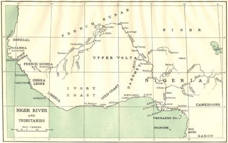
AFRICA. Niger River and Tributaries 1936 old vintage map plan chartJasper524.5(9.8k)See Sold PriceFeb 28, 2024
Colonial West Africa. Nigeria Cameroon Congo. British German. TIMES 1895 mapJasper524.5(9.8k)See Sold PriceFeb 28, 2024
SOUTHERN AFRICA. 'Namaqua Hottentots'. Khoikhoi. Namibia. From TACHARD 1746Jasper524.5(9.8k)See Sold PriceFeb 28, 2024
Africa by Arrowsmith & Lewis 1812 old antique vintage map plan chartJasper524.5(9.8k)See Sold PriceFeb 28, 2024
![Mitchell: Antique Map of Africa [verso] Oceania, 1878 First Image](https://p1.liveauctioneers.com/5584/113160/58115910_1_x.jpg?height=282&quality=95&version=1512524398&width=282)

![Mitchell: Antique Map of Africa [verso] Oceania, 1878 First Image](https://p1.liveauctioneers.com/5584/113160/58115910_1_x.jpg?height=282&quality=1&version=1512524398&width=282)


![Mitchell: Antique Map of Africa [verso] Oceania, 1878 (1 of 2)](https://p1.liveauctioneers.com/5584/113160/58115910_1_x.jpg?height=282&quality=70&version=1512524398)

![1858 Mitchell Map of Africa [verso] Oceania and Hawaii (1 of 2)](https://p1.liveauctioneers.com/5584/172819/87010514_1_x.jpg?height=282&quality=70&version=1594158786)
![1876 Mitchell map of Africa [verso] Oceania / Australia (1 of 2)](https://p1.liveauctioneers.com/5584/167106/84290444_1_x.jpg?height=282&quality=70&version=1588107786)
![1869 Mitchell Map of Africa [verso] Oceania -- XL (1 of 2)](https://p1.liveauctioneers.com/5584/195879/98794856_1_x.jpg?height=282&quality=70&version=1614724478)
![1858 Mitchell Map of Africa [verso] Oceania and Hawaii (1 of 2)](https://p1.liveauctioneers.com/5584/153142/77325843_1_x.jpg?height=282&quality=70&version=1572400045)
![1858 Mitchell Map of Africa [verso] Oceania and Hawaii (1 of 2)](https://p1.liveauctioneers.com/5584/159675/80583552_1_x.jpg?height=282&quality=70&version=1579644740)
![1876 Mitchell map of Africa [verso] Oceania / Australia (1 of 2)](https://p1.liveauctioneers.com/5584/157856/79674973_1_x.jpg?height=282&quality=70&version=1577197209)
![1876 Mitchell map of Africa [verso] Oceania / Australia (1 of 2)](https://p1.liveauctioneers.com/5584/131384/66769350_1_x.jpg?height=282&quality=70&version=1542734392)
![1876 Mitchell map of Africa [verso] Oceania / Australia (1 of 2)](https://p1.liveauctioneers.com/5584/140407/71160741_1_x.jpg?height=282&quality=70&version=1556054096)
![1876 Mitchell map of Africa [verso] Oceania / Australia (1 of 2)](https://p1.liveauctioneers.com/5584/135983/69029351_1_x.jpg?height=282&quality=70&version=1550020660)
![1876 Mitchell map of Africa [verso] Oceania / Australia (1 of 2)](https://p1.liveauctioneers.com/5584/120869/61529812_1_x.jpg?height=282&quality=70&version=1524613752)
![1876 Mitchell map of Africa [verso] Oceania / Australia (1 of 2)](https://p1.liveauctioneers.com/5584/126688/64430448_1_x.jpg?height=282&quality=70&version=1535502838)
![Mitchell: Antique Map of Asia [verso] Middle East, 1878 (1 of 2)](https://p1.liveauctioneers.com/5584/113160/58115914_1_x.jpg?height=282&quality=70&version=1512524398)
![Mitchell: Antique Map of Asia [verso] Middle East 1878 (1 of 2)](https://p1.liveauctioneers.com/5584/117349/60339353_1_x.jpg?height=282&quality=70&version=1520390147)
![Mitchell: Antique Map of Asia [verso] Middle East, 1878 (1 of 2)](https://p1.liveauctioneers.com/5584/115727/59467900_1_x.jpg?height=282&quality=70&version=1517366492)