SoldMATTH. SEUTTER 18TH C. MAP OF AMSTERDAMCa. mid 18th c. hand-colored map. Fold down the center. 19.25 x 22.25" sight.See Sold Price
SoldSeutter, Hand Colored Map, Asia Minor, 18th C.German, circa 1770. "Natoliae olim Asiae Minoris Tabula per Matth. Seutterum"-circa 1770, hand colored copperplate cartographic engraving by Georg Matthäus Seutter (German, 1678-1757) published in AuSee Sold Price
SoldAlbrecht Carl Seutter, 18th C. Map of DenmarkAlbrecht Carl Seutter (German, 1722-1762), ""Daniae Regni Typus", engraving with hand coloring on paper, lower right margin with "A.C. Seutter delin 14". Hand colored map depicting Denmark, title in rSee Sold Price
Sold18TH C. HANDCOLORED ENGRAVED MAP OF AMSTERDAMDimensions: (Frame) H 15.75" x W 16", (Sight) H 9.75" x W 10.25" Condition: Some age toning and spotting.See Sold Price
Sold18th C. Seutter Map of India including SE Asia.Approx 1740. Dimensions: 19.3" h x 23.5" image. Condition: Appears good, age appropriate, not examined outside frame.See Sold Price
Sold18th c. Hand-colored mapSeutter, Georg Matthaus 18th c. hand-colored map- ''Plan De La Cupitale Et Fortresse Midolebour...Augsbourg''- Town plan in color with an uncoloured general view above bottom margin, embellished withSee Sold Price
SoldAntique Map Georg Matthaus Seutter 18th C.18th C. antique map is third state of Seutter's map based on Jansson's map of 1651. Hand colored and embellished with decorations and animal figures. Shows boundaries of Massachusetts, New England, NeSee Sold Price
SoldNicolas Sanson/ Pierre Mortier, engraving mapNicolas Sanson/ Pierre Mortier , "Gallia Vetus...", 18th c., printed in Amsterdam, engraved map of France, outline color, elaborate cartouche, sight 20 1/4 in. x 16 3/4 in., framed * NO RETURNS ARE ACSee Sold Price
SoldLarge and impressive 18th C. map of the Empire of JapanA large and impressive map of the Empire of Japan, by Mattheus Seuter, Amsterdam, 1720-1740. The title: Empire of Japan in 66 Regions. The land areas fully colored, but title cartouche to Benjamin DutSee Sold Price
SoldGuillaume de L'isle 18th C. Map of Asia, NorthernAuthor: Guillaume de L'isle. Hand Colored Published in 1760 in de I'Isle/Pierre Mortier, Amsterdam "Carte de Tartarie Dressee sur les Relations deSee Sold Price
SoldSeutter, Hand Colored Map, Persia, 18th C.German, circa 18th century. "Opulentissimi Regni Persiae juxta suas Provincias recentissima et accuratissima Designatio, Studio et Sumtibus"-circa 1730/1740, hand colored copperplate cartographic engrSee Sold Price
Sold18thC Hand-Colored Map, Germany, M. Seutter18th century hand-colored map, Germania Augustiniana by Matthaus Seutter, S.C.M. (German, 1678-1757), framed 28" x 31". Provenance: Del Mar, California collection.See Sold Price
Sold(2) 18TH C ENGRAVED MAPS - 'Hollandia Comitatus' by(2) 18TH C ENGRAVED MAPS - 'Hollandia Comitatus' by Willem Janszoon Blaeu (1571-1638), Amsterdam, circa 1635. The upper right corner inset with map of the isles Texel, Vlieland and Terschelling; PLUSSee Sold Price
(2) 18TH C ENGRAVED MAPS - 'Hollandia Comitatus' by(2) 18TH C ENGRAVED MAPS - 'Hollandia Comitatus' by Willem Janszoon Blaeu (1571-1638), Amsterdam, circa 1635. The upper right corner inset with map of the isles Texel, Vlieland and Terschelling; PLUSSee Sold Price
SoldRARE 18TH C. FRENCH MAP OF SCANDINAVIANicolas Sanson, "La Scandinavie, et les Environs, ou sont Les Royaumes de Suede, de Danemark et de Norwege divises en leurs principales Provinces": published by Pierre Schenk, Amsterdam, ca. 1700. CopSee Sold Price
16th / 18th C. European Maps of New Spain (2)Cartographer: Gerard Mercator. "Hispaniae Novae Nova Descriptio" Published by I.E. Cloppenburgh, Amsterdam, 1632. AND Stieler's "Mexico Und Centro-America …" Gotha, 1828. Two fascinating antique mapSee Sold Price
SoldMatthaus Seutter hand colored engraved mapMatthaus Seutter hand colored engraved map, early 18th c., inscribed Europa Religionis Christianae Morum et Pacis ac Belli Artium Cultu Omnium Terrarum Orbis Partium Praestantiss...., 20'' x 23''. ProSee Sold Price
18th/19th C. Map18th/19th C. map. Nieuwe Kaart van Irak Arabi- Kurdistan- Diarbek - Turkomannia- Syrie- enhet- Heilige Land- uitgegen te Amsterdam- by Isaak Tirion sight size 10.75" x 13 3/8" plate mark visible arounSee Sold Price
SoldSeutter, Hand Colored Map, Ottoman Empire, 18th C.German, circa 18th century. "Magni Turcarum Dominatoris Imperium per Europam, Asiam, et Africam se extendens Regiones tam proprias quam tributarias et clientelares ut et omnes Beglerbegatus sive PraefSee Sold Price
SoldSeutter, Hand Colored Map, Central Asia, 18th C.German, circa 1770. "Imperi Magni Mogolis sive Indici Padschach"-circa 1740, hand colored copperplate cartographic engraving by Georg Matthäus Seutter (German, 1678-1757) published in Ausburg. A GermSee Sold Price
SoldA LARGE 18TH C HAND COLORED MAP OF RUSSIAA LARGE 18TH C HAND COLORED MAP OF RUSSIA. Comprising a large finely engraved map entitled "MAPPAE IMPERII MOSCOVITICI PARS SEPTENTRIONALIS," by George Matthäus Seutter (1678-1757) printed in AugsburSee Sold Price
SoldLarge Lot of 18th and 19th c. Maps of EuropeGroup of 29 18th and 19th c. maps of Europe including maps of Antwerp, Brussels, Berlin, England, Scandinavia, Amsterdam, Dublin, the Plymouth Sound, Vienna, Venice, Cunersdorf, Prague, Dresden, ParisSee Sold Price
18th C Large Handcolored Mercator Map GermanyLarge beautifully handcolored map of Braunswyck and Meydburg after Gerard Mercator circa 1640, this being an 18th century restike.. Printed at Amsterdam. Measures 23 x 19". Fine, reinforced central veSee Sold Price
Sold18th C Large Handcolored Mercator Map GermanyLarge beautifully handcolored map of Braunswyck and Meydburg after Gerard Mercator circa 1640, this being an 18th century restike.. Printed at Amsterdam. Measures 23 x 19". Fine, reinforced central veSee Sold Price
LARGE LATE 17TH C. DUTCH CHART OF CANADA, GREAT LAKES, NEW FRANCE, LABRADOR, HUDSON BAY, BY PIERREThomaston Place Auction Galleries4.4(393)See Sold PriceFeb 24, 2024
17TH C. WORLD MAP BY NICOLAES VISSCHER (NETHERLANDS, 1618-1709)Thomaston Place Auction Galleries4.4(393)See Sold PriceFeb 24, 2024
EARLY 18TH C. DUTCH CHART OF PACIFIC OCEAN BY FREDERIK DE WIT (1629-1706) WITH CALIFORNIA AS ANThomaston Place Auction Galleries4.4(393)See Sold PriceFeb 24, 2024
LARGE EARLY 18TH C. DUTCH CHART OF UPPER NORTH AMERICA, PIERRE MORTIER (1661-1711), FRAMEDThomaston Place Auction Galleries4.4(393)See Sold PriceFeb 24, 2024
EARLY 18TH C. MAP OF ITALY, FRAMEDThomaston Place Auction Galleries4.4(393)See Sold PriceFeb 24, 2024
18TH C. ANTIQUE MAP: FRENCH & INDIAN WAR, FRAMEDThomaston Place Auction Galleries4.4(393)See Sold PriceFeb 24, 2024
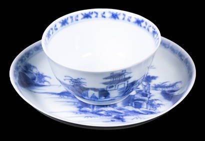
CHINESE NANKING CARGO CUP & SAUCERThomaston Place Auction Galleries4.4(393)See Sold PriceFeb 24, 2024
18th c. Cornelis Troost Miniature Portrait of Philips ZweertsHeritage Gallery Auctions4.4(60)See Sold PriceMar 10, 2024
Hendrik Scholten Mid 18th c. Illustration of Young LadyHeritage Gallery Auctions4.4(60)See Sold PriceMar 10, 2024
18th Century Hess Germany Hand colored Engraved MapGlobal Auctions Company4.3(36)See Sold PriceMar 03, 2024
Two (2) Antique 18th C. Copper Engraved Framed Maps - America & EuropeMagnusson Art Group4.5(53)See Sold PriceMar 14, 2024
1758 MAP PARTIE DE LA MER GLACIALE contenants La Nouvelle Zemble RUSSIA antiqueJasper524.5(9.9k)See Sold PriceFeb 27, 2024
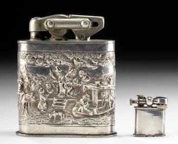
20th C. Mexican & Dutch Silver & Plated Lighters (2)Artemis Fine Arts4.8(1.4k)See Sold PriceFeb 26, 2024
1742 BIBLE IN FRENCH, ANCIENT, LEATHER-BOUND, OLD AND NEW TESTAMENTNY Elizabeth 4.2(86)See Sold PriceMar 03, 2024