ATLAS of ANTIENT GEOGRAPHY by SAMUEL BUTLER 1843John McInnis Auctioneers,LLC4.5(494)See Sold PriceFeb 24, 2024
18TH C. ANTIQUE MAP: FRENCH & INDIAN WAR, FRAMEDThomaston Place Auction Galleries4.4(386)See Sold PriceFeb 24, 2024
Rand McNally Railroad Map Cabinet w/ 21 Railroad MapsRail & Road Auctions4.6(165)See Sold PriceMar 08, 2024
Keith Haring - Ink on New York Map, Best Buddies, Inscribed, Signed, and DatedSapphire Auction Gallery3.9(67)See Sold PriceMar 02, 2024
LATE 17TH C. FRENCH MAP OF THE NEW WORLD BY ALEXIS-HUBERT JAILLOT (1632-1712)Thomaston Place Auction Galleries4.4(386)See Sold PriceFeb 24, 2024
Central Railroad of New Jersey Map of Sandy Hook Route-ca. 1903JM Hobby Supply and Railroad Artifact Auctions4.4(126)See Sold PriceFeb 24, 2024
Lot of Six Mixed Atlas Box Cars-HO Scale-New in BoxJM Hobby Supply and Railroad Artifact Auctions4.4(126)See Sold PriceFeb 25, 2024
Rand McNally/Santa Fe Railroad Map of Iowa-1912JM Hobby Supply and Railroad Artifact Auctions4.4(126)See Sold PriceFeb 24, 2024
NICOLAES VISSCHER (NETHERLANDS, 1618-1709) MAP OF THE NEW WORLDThomaston Place Auction Galleries4.4(386)See Sold PriceFeb 24, 2024
17TH C. WORLD MAP BY NICOLAES VISSCHER (NETHERLANDS, 1618-1709)Thomaston Place Auction Galleries4.4(386)See Sold PriceFeb 24, 2024
Lot of Six Mixed Atlas Cabooses-HO Scale-New in BoxJM Hobby Supply and Railroad Artifact Auctions4.4(126)See Sold PriceFeb 25, 2024
Massive Long Island Sound Coast ChartHassler, Ferdinand R. (1770-1843), & U.S. Coast Survery. Eastern Part of Long Island Sound | Middle Part of Long Island Sound | Western Long Island Sound Three engraved maps. GPO, 1855. 105" wide if aSee Sold Price
Sold3 Coast Chart of Long Island SoundLong Island Sound... From a Trignometrical survey under the direction of F. R. Hassler and A. D. Bache Superintendents of the Survey Of The Coast Of The United States. U.S. Coast Survey. Washington, 1See Sold Price
SoldEldridges chart of Long Island SoundLater copy of an 1875 chart of Long Island Sound as drawn by George Eldridge, Hydrographer. Chart shows the coast of Long Island Sound from Mamaroneck New York to Newport Rhode Island. Other ports shoSee Sold Price
19th century chart, Long Island.1894 U.S. Coast survey chart titled “Coast Chart 115, Plum Island to Stratford Shoal, Long Island Sound”. Shows Shelter Island, Milford, New Haven, Saybrook, Madison, Lime, Guilford, Port JeffersoSee Sold Price
THREE LONG ISLAND SOUND CHARTSThree original framed charts showing the coast of Long Island Sound by THE UNITED STATES COAST SURVEY. Showing sections of Long Island, the coast of Connecticut, up to Rhode Island. Dimensions: 23 talSee Sold Price
SoldAntique Chart of Long Island SoundChart of Long Island SoundShowing Light Stations from Block Island to New YorkAdapted for use in the New England Almanac from US Coast Survey Charts by L.E. Daboll Undated, but believed to have come fSee Sold Price
Sold3-sheet chart of Long Island Sound 1855Title: Long Island Sound. Western Sheet [in set with] Middle Part of Long Island Sound [and] Eastern Part of Long Island Sound Author: U.S. Coast Survey Description: Together, 3 sheet forming one largSee Sold Price
Land Ho! Antique N. Shore of the L.I. Sound, CTDescription: Ahoy! Antique Coast Guard nautical chart of the North Shore of the Long Island Sound, CT. Numbered C. & G. S. 219; dated 1969; Coast Guard corrections denoted in purple. Material: paper.See Sold Price
Land Ho! Antique N. Shore of the L.I. Sound, CTDescription: Ahoy! Antique Coast Guard nautical chart of the North Shore of the Long Island Sound, CT. Numbered C. & G. S. 219; dated 1969; Coast Guard corrections denoted in purple. Material: paper.See Sold Price
Land Ho! Antique N. Shore of the L.I. Sound, CTDescription: Ahoy! Antique Coast Guard nautical chart of the North Shore of the Long Island Sound, CT. Numbered C. & G. S. 219; dated 1969; Coast Guard corrections denoted in purple. Material: paper.See Sold Price
SoldChart of Long Island SoundLater copy of a 1875 Eldridge chart of Long Island Sound from Newport to New York. Showing all ports on Long Island Sound, right on the coast of Connecticut to Newport, and the north coast of Long IslSee Sold Price
SoldChart of Long Island Sound - Western PartOriginal chart of the Connecticut and NewYork coast of Long Island Sound. Showing the Connecticut coast from Stratford to New York City. Dated 1932. Nicely framed. 35 x 46See Sold Price
SoldNautical Map / Sea Chart, #1212 Eastern Long IslandDescription: Nautical Map / Sea Chart, United States East Coast, Connecticut - New York, Long Island Sound, Eastern Part, 12th edition feb 10 / 69 ; all measurements are approximate; Folded; ShippingSee Sold Price
Nautical Map / Sea Chart, #1212 Long Island Sound -Description: Nautical Map / Sea Chart, United States East Coast, Connecticut - New York, Long Island Sound East, New London Harbor, Long Island Sound Eastern Part, 8th edition Jul/29/63 stamped w/ NOTSee Sold Price
Nautical Map / Sea Chart, #1212 Long Island Sound -Description: Nautical Map / Sea Chart, United States East Coast, Connecticut - New York, Long Island Sound East, New London Harbor, Long Island Sound Eastern Part, 8th edition Jul/29/63 stamped w/ NOTSee Sold Price
Nautical Map / Sea Chart, #1212 Eastern Long IslandDescription: Nautical Map / Sea Chart, United States East Coast, Connecticut - New York, Long Island Sound, Eastern Part, 12th edition feb 10 / 69 ; all measurements are approximate; Folded; ShippingSee Sold Price
Nautical Map / Sea Chart, #1212 Eastern Long IslandDescription: Nautical Map / Sea Chart, United States East Coast, Connecticut - New York, Long Island Sound, Eastern Part, 12th edition feb 10 / 69 ; all measurements are approximate; Folded; ShippingSee Sold Price
Nautical Map / Sea Chart, #1212 Long Island Sound -Description: Nautical Map / Sea Chart, United States East Coast, Connecticut - New York, Long Island Sound East, New London Harbor, Long Island Sound Eastern Part, 8th edition Jul/29/63 stamped w/ NOTSee Sold Price
Nautical Map / Sea Chart, #1212 Eastern Long IslandDescription: Nautical Map / Sea Chart, United States East Coast, Connecticut - New York, Long Island Sound, Eastern Part, 12th edition feb 10 / 69 ; all measurements are approximate; Folded; ShippingSee Sold Price
Nautical Map / Sea Chart, #1212 Long Island Sound -Description: Nautical Map / Sea Chart, United States East Coast, Connecticut - New York, Long Island Sound East, New London Harbor, Long Island Sound Eastern Part, 8th edition Jul/29/63 stamped w/ NOTSee Sold Price
Nautical Map / Sea Chart, #1212 Long Island Sound -Description: Nautical Map / Sea Chart, United States East Coast, Connecticut - New York, Long Island Sound East, New London Harbor, Long Island Sound Eastern Part, 8th edition Jul/29/63 stamped w/ NOTSee Sold Price
Nautical Map / Sea Chart, #1212 Eastern Long IslandDescription: Nautical Map / Sea Chart, United States East Coast, Connecticut - New York, Long Island Sound, Eastern Part, 12th edition feb 10 / 69 ; all measurements are approximate; Folded; ShippingSee Sold Price
Nautical Map / Sea Chart, #1212 Eastern Long IslandDescription: Nautical Map / Sea Chart, United States East Coast, Connecticut - New York, Long Island Sound, Eastern Part, 12th edition feb 10 / 69 ; all measurements are approximate; Folded; ShippingSee Sold Price
Nautical Map / Sea Chart, #1212 Long Island Sound -Description: Nautical Map / Sea Chart, United States East Coast, Connecticut - New York, Long Island Sound East, New London Harbor, Long Island Sound Eastern Part, 8th edition Jul/29/63 stamped w/ NOTSee Sold Price
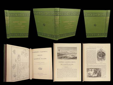
1874 HAWAII 1ed Northern California Oregon Pacific Island Travel Puget RedwoodsSchilb Antiquarian Rare Books4.8(415)See Sold PriceMar 10, 2024
LATE 18TH C. VERY LARGE CHART OF NORTHEAST CANADA BY DES BARRES (1721-1824), 1780, FRAMEDThomaston Place Auction Galleries4.4(386)See Sold PriceFeb 24, 2024
CHART "LONG ISLAND SOUND FROM NEW YORK TO MONTOCK POINT ..." New York, 1830 21" x 77" sight. FramedEldred's4.7(403)See Sold PriceFeb 27, 2024
CHART "SOUTHERN COAST OF LONG ISLAND FROM MONTAUK POINT TO EAST HAMPTON" Circa 1877 11.25" x 22.75"Eldred's4.7(403)See Sold PriceFeb 27, 2024
Harry Barton, Mother and daughter with ParasollLotus International Auctions, LLC4.6(153)See Sold PriceMar 03, 2024
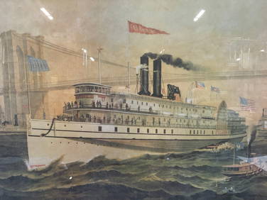
Iron Mountain Of Long Island Sound Litho J GleasonThe Benefit Shop Foundation Inc.4.3(2.9k)See Sold PriceMar 06, 2024
Scalamandre Window Treatments, Curtains, Drapery Rainbow Stripe, Fringed, LinedJasper524.5(9.7k)See Sold PriceFeb 28, 2024
Single Cream Curtain on Valance, Window Treatment, DraperyJasper524.5(9.7k)See Sold PriceFeb 28, 2024
French Solid Bronze Six Light Chandelier, Canopy, Chain, Estate ItemJasper524.5(9.7k)See Sold PriceFeb 28, 2024
Louis XVI 19th Century Dore Bronze Chandelier, Six Light, Estate ItemJasper524.5(9.7k)See Sold PriceFeb 28, 2024
West Indies Windward Lesser Antilles. Martinique (Belonging to France)Jasper524.5(9.7k)See Sold PriceFeb 27, 2024
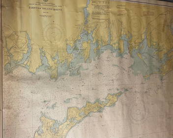
CHART: UNITED STATES - EAST COAST/ RHODE ISLAND - CONNECTICUT - NEW YORK/ Fishers IslandChurchill Galleries3.7(208)See Sold PriceFeb 26, 2024