ATLAS of ANTIENT GEOGRAPHY by SAMUEL BUTLER 1843John McInnis Auctioneers,LLC4.6(502)See Sold PriceFeb 24, 2024
18TH C. ANTIQUE MAP: FRENCH & INDIAN WAR, FRAMEDThomaston Place Auction Galleries4.4(386)See Sold PriceFeb 24, 2024
Rand McNally Railroad Map Cabinet w/ 21 Railroad MapsRail & Road Auctions4.6(165)See Sold PriceMar 08, 2024
Keith Haring - Ink on New York Map, Best Buddies, Inscribed, Signed, and DatedSapphire Auction Gallery4(67)See Sold PriceMar 02, 2024
LATE 17TH C. FRENCH MAP OF THE NEW WORLD BY ALEXIS-HUBERT JAILLOT (1632-1712)Thomaston Place Auction Galleries4.4(386)See Sold PriceFeb 24, 2024
Central Railroad of New Jersey Map of Sandy Hook Route-ca. 1903JM Hobby Supply and Railroad Artifact Auctions4.4(126)See Sold PriceFeb 24, 2024
Lot of Six Mixed Atlas Box Cars-HO Scale-New in BoxJM Hobby Supply and Railroad Artifact Auctions4.4(126)See Sold PriceFeb 25, 2024
Rand McNally/Santa Fe Railroad Map of Iowa-1912JM Hobby Supply and Railroad Artifact Auctions4.4(126)See Sold PriceFeb 24, 2024
NICOLAES VISSCHER (NETHERLANDS, 1618-1709) MAP OF THE NEW WORLDThomaston Place Auction Galleries4.4(386)See Sold PriceFeb 24, 2024
17TH C. WORLD MAP BY NICOLAES VISSCHER (NETHERLANDS, 1618-1709)Thomaston Place Auction Galleries4.4(386)See Sold PriceFeb 24, 2024
Lot of Six Mixed Atlas Cabooses-HO Scale-New in BoxJM Hobby Supply and Railroad Artifact Auctions4.4(126)See Sold PriceFeb 25, 2024
SoldMaps of Arizona (86813)5 maps showing topography & aeriel photo's (1947) from the U.S. Dept. of the Army Corp of Engineers. (Lookout Mtn, Saddle Mtn.) approx. 28" x 22"; Geologic Atlas of the U.S. Folio, Arizona by F.L. RanSee Sold Price
Maps of Arizona 868135 maps showing topography & aeriel photo's (1947) from the U.S. Dept. of the Army Corp of Engineers. (Lookout Mtn, Saddle Mtn.) approx. 28" x 22"; Geologic Atlas of the U.S. Folio, Arizona by F.L. RanSee Sold Price
MAP - Arizona, Utah, Grand Canyon. DuttonNorthern Arizona, Southern Utah, Grand Canyon. Clarence Edward Dutton, Geological Map of the Western Part of the Plateau Province, 1882 (published). Printed Color. This map was issued in the quarto edSee Sold Price
MAP, Arizona Territory, U.S. Dept. of InteriorArizona Territory. U.S. Department of Interior, Dept. of the Interior Pacific Wagon Roads. Map No. 1 of the El Paso & Fort Yuma Wagon Road..., from Wagon Roads... A Report Upon the Several Roads ConstSee Sold Price
SoldCounty Map Arizona, Calf. C. 1875County map of Arizona and Southern California, as well as County map of California and Nevada. 1875 15x25".See Sold Price
SoldMitchell: Antique Map of Arizona & New Mexico, 1870Map: Arizona and New Mexico Cartographer: S. A. Mitchell Place & Date: Philadelphia / 1870 Size: 14 1/8" x 11 1/2" Condition: full color; light overall age toning The beautifully detailed and coloredSee Sold Price
1877 Mitchell Map of Utah and Nevada [verso] ArizonaTitle/Content of Map: 1877 Mitchell Map of Utah and Nevada [verso] Arizona and New Mexico -- County Map of of Utah and Nevada [verso] County Map Arizona and New Mexico Cartographer: S Mitchell Year/PlSee Sold Price
Map of New Mexico and Arizona.Publication Date: c1891 Title: Map of New Mexico and Arizona. Publisher: MATTHEWS-NORTHRUP CO. Height: 9.5” Width: 12.0” The Matthews-Northrup Up-to-Date Map Arizona and New Mexico IndexedSee Sold Price
Map of New Mexico and Arizona.Title: Map of New Mexico and Arizona. Publication Date: 1891 ca. Cartographer: Publisher: MATTHEWS-NORTHRUP CO. Size: 9.5â€X12.0†The Matthews-Northrup Up-to-Date Map Arizona and New Mexico IndSee Sold Price
Arizona & New Mexico 1903Title/Content of Map: Arizona & New Mexico 1903 Date Printed: 1903 Material/Medium: Paper Size: approx 10.5x13 inches Additional Info: The Crowell Publishing Co., Twentieth Century Peerless Atlas ReseSee Sold Price
Sold1876 Mitchell Map of Utah and Nevada [verso] ArizonaTitle/Content of Map: 1876 Mitchell Map of Utah and Nevada [verso] Arizona and New Mexico -- County Map of of Utah and Nevada [verso] County Map Arizona and New Mexico Date: 1876 Philadelphia CartograSee Sold Price
Arizona & New Mexico 1903Title/Content of Map: Arizona & New Mexico 1903 Date Printed: 1903 Material/Medium: Paper Size: approx 10.5x13 inches Additional Info: The Crowell Publishing Co., Twentieth Century Peerless Atlas ReseSee Sold Price
Arizona & New Mexico 1903Title/Content of Map: Arizona & New Mexico 1903 Date Printed: 1903 Material/Medium: Paper Size: approx 10.5x13 inches Additional Info: The Crowell Publishing Co., Twentieth Century Peerless Atlas ReseSee Sold Price
1877 Mitchell Map of Utah and Nevada [verso] ArizonaTitle/Content of Map: 1877 Mitchell Map of Utah and Nevada [verso] Arizona and New Mexico -- County Map of of Utah and Nevada [verso] County Map Arizona and New Mexico Cartographer: S Mitchell Year/PlSee Sold Price
1877 Mitchell Map of Utah and Nevada [verso] ArizonaTitle/Content of Map: 1877 Mitchell Map of Utah and Nevada [verso] Arizona and New Mexico -- County Map of of Utah and Nevada [verso] County Map Arizona and New Mexico Cartographer: S Mitchell Year/PlSee Sold Price
1877 Mitchell Map of Utah and Nevada [verso] ArizonaTitle: 1877 Mitchell Map of Utah and Nevada [verso] Arizona and New Mexico -- County Map of of Utah and Nevada [verso] County Map Arizona and New Mexico Cartographer: S Mitchell Year / Place: 1877 PhiSee Sold Price
SoldHostile Apache IndiansHeading: (Map - Arizona) Author: Spencer, E. J. Title: Outline Map of the Field of Operations against Hostile Chiricahua Indians, showing operations from April 12, 1886 to the date of their surrenderSee Sold Price
1877 Mitchell Map of Utah and Nevada [verso] ArizonaTitle: 1877 Mitchell Map of Utah and Nevada [verso] Arizona and New Mexico -- County Map of of Utah and Nevada [verso] County Map Arizona and New Mexico Cartographer: S Mitchell Year / Place: 1877 PhiSee Sold Price
1877 Mitchell Map of Utah and Nevada [verso] ArizonaTitle: 1877 Mitchell Map of Utah and Nevada [verso] Arizona and New Mexico -- County Map of of Utah and Nevada [verso] County Map Arizona and New Mexico Cartographer: S Mitchell Year / Place: 1877 PhiSee Sold Price
Sold1886 County & Township map of Arizona & N. Mexico byA fine example of William M. Bradley's 1886 map of Arizona and New Mexico. Shows just ten counties in Arizona Territory and thirteen in New Mexico Territory (plus Indian Reservation in upper left of sSee Sold Price
SoldMap of Arizona by George F. CramItem: Map of Arizona by George F. Cram Date: 1887 Dimensions: 11.25 x 13.5 in Please note that this lot has a confidential reserve. When you leave a bid in advance of the auction, submit your maximum.See Sold Price
SoldMitchell: Antique Map of Arizona and New Mexico, 1870Title/Content of Map: 1870 Mitchell Map of Arizona and New Mexico -- Arizona and New Mexico Date Printed: 1870, Philadelphia Cartographer: S Mitchell Size: 11.5 X 13.8 in. Handsome map of these two deSee Sold Price
SoldMap of Arizona, 1902Title: Map of Arizona Original engraving by George Cram Date: 1902 Dimensions: 11 1/2 x 14 1/2 inches No Reserve: This lot starts at $1 and has no reserve as a courtesy so that collectors can determinSee Sold Price
Sold1887 Map of ArizonaAuthor: Watson Title: 1887 Map of Arizona Medium: Ink on Paper Dimensions: 11"X16.5" Map of Arizona, dated 1887 engraved for Watson's General Atlas. Color coded for counties. Explanation on the rightSee Sold Price
Rand McNally Railroad Map of Arizona-1909JM Hobby Supply and Railroad Artifact Auctions4.4(126)See Sold PriceFeb 24, 2024
1885 CIVIL WAR 1ed Famous Memoirs US Grant Sheridan Sherman 6v RARE LOT MapsSchilb Antiquarian Rare Books4.8(421)See Sold PriceMar 10, 2024
Stunning 5.3/4" Effigy Bowl, Hohokam, Found in Arizona. Well made with four high relief separatHeartland Artifact Auctions Inc4.7(780)See Sold PriceFeb 25, 2024
8.3/8" Paint Pallet, Hohokam, Made from high grade sparkly sandstone. Arizona. Well finished withHeartland Artifact Auctions Inc4.7(780)See Sold PriceFeb 25, 2024
Awesome Historic Catlinite Frog Effigy, Made from red pipestone, From Arizona, Zuni Fetish. 1.3/16"Heartland Artifact Auctions Inc4.7(780)See Sold PriceFeb 25, 2024
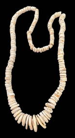
Hohokam Burial Necklace ca 1200 AD Original Anasazi Beads ArizonaCowboy Joe's Antiques4.7(189)See Sold PriceFeb 27, 2024
Large lot of assorted prints. 18th-20th century. To include: North American and other maps, CivilTremont Auctions4.6(293)See Sold PriceFeb 25, 2024
Large Assortment of Railroad Items - Insulators, Globes, Hand Bell, Posters, Maps, Timetables,Rail & Road Auctions4.6(165)See Sold PriceMar 07, 2024
Collection of Allied Military Silk Printed Maps, WWII Era and LaterMaterial Culture4.6(765)See Sold PriceFeb 29, 2024
Rand McNally Railroad Map Cabinet w/ 21 Railroad MapsRail & Road Auctions4.6(165)See Sold PriceMar 08, 2024
War Diary of 354th Infantry - 89th Division 1919North American Artifact Auctions4.6(182)See Sold PriceApr 20, 2024
Willem Blaeu, Etc. 17th C. Antiquarian Maps, 2Auctions at Showplace4.5(726)See Sold PriceMar 17, 2024
Putnam - First Map of the State of Ohio by Rufus PutnamTrillium Antique Prints & Rare Books4.5(30)See Sold PriceFeb 24, 2024
De Jode, Rare, pub. 1593 - Map of Africa (Africae Vera Forma, et Situs)Trillium Antique Prints & Rare Books4.5(30)See Sold PriceFeb 24, 2024
8 1/2" dia St Johns Polychrome, broken and glued, found in Arizona deconsessioned Arkansas RiverHeartland Artifact Auctions Inc4.7(780)See Sold PriceMar 10, 2024
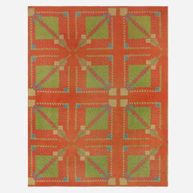
After Frank Lloyd Wright, Carpet from the Arizona Biltmore HotelLos Angeles Modern Auctions4.4(24)See Sold PriceFeb 28, 2024
Francis McNally - Antique Map of Washington, Oregon, Idaho, Nevada, Utah & ArizonaProverde Auctions4.3(3)See Sold PriceFeb 28, 2024


![1877 Mitchell Map of Utah and Nevada [verso] Arizona (1 of 2)](https://p1.liveauctioneers.com/5584/175972/88577723_1_x.jpg?height=282&quality=70&version=1597183226)


![1876 Mitchell Map of Utah and Nevada [verso] Arizona (1 of 2)](https://p1.liveauctioneers.com/5584/137769/69881187_1_x.jpg?height=282&quality=70&version=1552435690)


![1877 Mitchell Map of Utah and Nevada [verso] Arizona (1 of 2)](https://p1.liveauctioneers.com/5584/179983/90569371_1_x.jpg?height=282&quality=70&version=1601417445)
![1877 Mitchell Map of Utah and Nevada [verso] Arizona (1 of 2)](https://p1.liveauctioneers.com/5584/171770/86526681_1_x.jpg?height=282&quality=70&version=1592950942)
![1877 Mitchell Map of Utah and Nevada [verso] Arizona (1 of 2)](https://p1.liveauctioneers.com/5584/198775/100468039_1_x.jpg?height=282&quality=70&version=1617141175)

![1877 Mitchell Map of Utah and Nevada [verso] Arizona (1 of 2)](https://p1.liveauctioneers.com/5584/188299/94765044_1_x.jpg?height=282&quality=70&version=1608072723)
![1877 Mitchell Map of Utah and Nevada [verso] Arizona (1 of 2)](https://p1.liveauctioneers.com/5584/192977/97276876_1_x.jpg?height=282&quality=70&version=1612304273)