ATLAS of ANTIENT GEOGRAPHY by SAMUEL BUTLER 1843John McInnis Auctioneers,LLC4.5(505)See Sold PriceFeb 24, 2024
18TH C. ANTIQUE MAP: FRENCH & INDIAN WAR, FRAMEDThomaston Place Auction Galleries4.4(393)See Sold PriceFeb 24, 2024
Rand McNally Railroad Map Cabinet w/ 21 Railroad MapsRail & Road Auctions4.6(165)See Sold PriceMar 08, 2024
Keith Haring - Ink on New York Map, Best Buddies, Inscribed, Signed, and DatedSapphire Auction Gallery4.1(67)See Sold PriceMar 02, 2024
LATE 17TH C. FRENCH MAP OF THE NEW WORLD BY ALEXIS-HUBERT JAILLOT (1632-1712)Thomaston Place Auction Galleries4.4(393)See Sold PriceFeb 24, 2024
Central Railroad of New Jersey Map of Sandy Hook Route-ca. 1903JM Hobby Supply and Railroad Artifact Auctions4.4(127)See Sold PriceFeb 24, 2024
Lot of Six Mixed Atlas Box Cars-HO Scale-New in BoxJM Hobby Supply and Railroad Artifact Auctions4.4(127)See Sold PriceFeb 25, 2024
Rand McNally/Santa Fe Railroad Map of Iowa-1912JM Hobby Supply and Railroad Artifact Auctions4.4(127)See Sold PriceFeb 24, 2024
NICOLAES VISSCHER (NETHERLANDS, 1618-1709) MAP OF THE NEW WORLDThomaston Place Auction Galleries4.4(393)See Sold PriceFeb 24, 2024
17TH C. WORLD MAP BY NICOLAES VISSCHER (NETHERLANDS, 1618-1709)Thomaston Place Auction Galleries4.4(393)See Sold PriceFeb 24, 2024
Lot of Six Mixed Atlas Cabooses-HO Scale-New in BoxJM Hobby Supply and Railroad Artifact Auctions4.4(127)See Sold PriceFeb 25, 2024
SoldMaps and Map Making (9) BooksGroup of nine books of maps and map making. Includes: 1) Two 1978 editions. The Compleat Plattmaker by Norman Thrower. 2) Proceedings of the Vinland Map Conference by Washburn. 1971. 3) American MapsSee Sold Price
A Collection of Books on Maps, Map Making, and Atlases.A Collection of Books on Maps, Map Making, and Atlases. Includes 'Hammond's World Atlas', 1936-37, and books on explorationSee Sold Price
SoldEight Coffee Table Books, Military & Map MakingEight Coffee Table Books, Military & Map Making: Map Makers Art, War Maps, Historical Atlas of the US Navy, Liberty, History of Cavalry, The Boer War, Napoleons Army, Victorian Colonial Warfare. (25-5See Sold Price
Sold(BOOKS ON BOOKS, CARTOGRAPHY) A group of 5 books on(BOOKS ON BOOKS, CARTOGRAPHY) A group of five books on map-making and map-makers, including Decorative Printed Maps of the 15th to 18th Centuries. By R.A. Skelton. London: Staples Press, (1952). MercaSee Sold Price
SoldMaps and Mapmaking (8)Group of eight books of maps and mapmaking. Includes: 1) The Papers of the Bibliographical Society of America; The Early Cartography of the Pacific. Volume 38, No. 2, 1944. 268 pp. with 22 plates. 2)See Sold Price
SoldLARGE LOT OF OLD MAPSINCLUDES LANDMARK MAPMAKING BOOK. LARGE VARIETY OF MAPS.maps are old, some are taped to boards, very fragile, and/or torn/cracking. ***Additional photo links available at http://paceantiques.com/See Sold Price
Sold9V HISTORY OF MAP MAKING AND CARTOGRAPHY Books-On-Books9V HISTORY OF MAP MAKING AND CARTOGRAPHY Books-On-Books Folio Oversized Illustrated Fold-Out Greek Roman Maps Globe of Martin Bylica of Olkusz Celestial Historical Survey of Study and Collecting R A SSee Sold Price
Sold9 Books + 45 Magazines: Map Reference.[Map Reference] 10 Titles (9 Books + 45 Magazines). ++ R. V. Tooley. THE MAPPING OFAMERICA. Holland Press, (1988). ++ Karrow (general editor). CHECKLIST OF PRINTED MAPS OF THE MIDDLE WEST TO 1900. VolSee Sold Price
Sold9 Books: 3 Map reference, 6 on Virginia.[Virginia/Map Reference]. 9 Titles. 12mo-4to. Hardcover (3 in dj). Sold with all faults. ++ Ann M. Peyton. MEMOIR OF JOHN HOWE PEYTON, In Sketches by his Contemporaries. Staunton, VA: A. B. BlackburnSee Sold Price
SoldLot Cartography & Map BooksLot includes: Cartography, Mapping Civilizations, Landmarks of Mapmaking, Railroad Maps of North America, the Mapmaker's Quest and The Island of Lost Maps. CONDITION: Some wear and minor bends to jackSee Sold Price
Grp: 9 Books and Maps about Europe and FranceGroup of books and maps about Europe, particularly focusing on France. Includes A. Hugo, "France Pittoresque ou Description Pittoresque, Topographique et Statitique Des Departements et colonies De LaSee Sold Price
Sold9 book plate maps9 book plate maps including Dominion of Canada and Newfoundland; Johnson's Roman Empire; South America. Foxing; tears; creases. Largest measures 27 inches x 18 inches.See Sold Price
Sold8 ROLLINS ANCIENT HISTORY FRAMED MAPS8 ROLLINS ANCIENT HISTORY FRAMED MAPS: 9 framed maps total, 8 from Rollins Ancient History books, drawn by D'Anville with various dates from 1738 to 1740, although these may be later impressions. To iSee Sold Price
Sold9 Maps & American Reference Books Incl. Wheat & B9 Maps & American Reference Books Incl. Wheat & Brun-- Dimensions: ---See Sold Price
Grouping of 9 vintage NY State related books including: "The Legislative Manual of the State Of NewGrouping of 9 vintage NY State related books including: "The Legislative Manual of the State Of New York For 1860" - published in Albany - complete with Assembly Chamber map 1860 - map with tears alonSee Sold Price
2 Books incl: LANDMARKS OF MAPMAKING.[Map Reference]. 2 Titles. ++ R.A. Skelton. DECORATIVE PRINTED MAPS OF THE 15TH TO 18TH CENTURIES. Lon & NY: Staples Press, (1952). Folio. 80 pages and 84 reproductions mostly in b&w. ++ LANDMARKS OFSee Sold Price
Landmarks Mapmaking an Illustrated Survey MapsLandmarks of Mapmaking. An Illustrated Survey of Maps and Mapmakers. Bricker, Charles and R.V. Tooley. Thomas Y. Crowell. First American edition. Folio. Illustrated. Related material laid in.See Sold Price
SoldThe Adjustment Bureau Map Book Movie PropsScreen used, brown leather bound Map Book with multiples map pages inside. (approx. 9 1/4" x 6 1/4")See Sold Price
4 Books incl: Tooley. LANDMARKS OF MAPMAKING. 1968[Reference] 4 Titles. 4to/folio. Hardcover in dj. ++ Tony Campbell. EARLY MAPS. Abbeville Pr., (1981). Near fine. ++ R. V. Tooley, Charles Bricker, and Gerald Roe Crone. LANDMARKS OF MAPMAKING. ElseviSee Sold Price
SoldBook : R V Tooveys Landmarks of Mapmaking an IllusBook : R V Tooveys Landmarks of Mapmaking an Illustrated Survey of Maps and Mapmakers published by Phaidon Oxford 1976 in dust jacket.See Sold Price
SoldHand-Tinted Map3/5" x 5" image, framed 7.75" x 9.5," book page, Anno 1646, map of America.See Sold Price
Sold[New Orleans Map][Antique New Orleans Map], "Lake Ponchartrain, Harbour & Breakwater, Louisiana", 1853, lithograph, folding map extracted from a book, sheet 9 in. x 38 inSee Sold Price
Sold3 map reference books: Tooley, LANDMARKS, 2 other[Reference]. 3 Titles. Folio. Hardcover in dj. Very good or better condition. ++ Landmarks Of Mapmaking. Selection by R.V. Tooley, text by Charles Brickner. (Oxford): Wordsworth, (1981). Several foldiSee Sold Price
SoldWILLIAM BUTLER "WILD NORTHLAND" Ltd edition 1903New York. New Amsterdam Book Company. 1903. 1/2 cloth bound. 101/210. pull out map 9 1/2 x 6 1/2 inchesSee Sold Price
1872 Holy BIBLE & Hitchcock Analysis Gruden Concordance Theology MAPS Holy LandSchilb Antiquarian Rare Books4.8(428)See Sold PriceMar 31, 2024
1738 BIBLE in DUTCH ILLUSTRATED w/ MAPS antique MASSIVE FOLIO BIBLIAJasper524.5(9.9k)See Sold PriceFeb 27, 2024
AFRICA. Pre 'Scramble for Africa'. BARTHOLOMEW 1876 old antique map plan chartJasper524.5(9.9k)See Sold PriceFeb 28, 2024
Coast & Islands between Cape Roxo. Guinea-Bissau & Bissagos. KITCHIN 1745 mapJasper524.5(9.9k)See Sold PriceFeb 28, 2024
Carte du Canal de Mosambique…. Madagascar Bonne Esperance. BONNE 1780 mapJasper524.5(9.9k)See Sold PriceFeb 28, 2024
États du Roi de Maroc… d’Alger, Tunis & Tripoli. North Africa. BONNE 1790 mapJasper524.5(9.9k)See Sold PriceFeb 28, 2024
Carte de la partie septentrionale d'Afrique, ou de la Barbarie… BONNE 1780 mapJasper524.5(9.9k)See Sold PriceFeb 28, 2024
Pre-SECOND WORLD WAR AFRICA. European colonies & German mandates 1942 old mapJasper524.5(9.9k)See Sold PriceFeb 28, 2024
BENIN TOGO GHANA COAST. 'Kingdoms of Koto, Popo, Fida/Whydah & Ardra' 1746 mapJasper524.5(9.9k)See Sold PriceFeb 28, 2024
East coast of Africa from the Cape… South Africa Mozambique. CHILD 1745 mapJasper524.5(9.9k)See Sold PriceFeb 28, 2024
CENTRAL AFRICA. Kongo. British & German East Africa. Kenya Tanzania 1907 mapJasper524.5(9.9k)See Sold PriceFeb 28, 2024
Le Canal de Mosambique, l'Isle de Madagascar… Mozambique. Africa. BONNE 1790 mapJasper524.5(9.9k)See Sold PriceFeb 28, 2024
AFRICA. Political Map of showing International Boundaries 1936 old vintageJasper524.5(9.9k)See Sold PriceFeb 28, 2024
World War 2 Europe Battle of the Atlantic 1939-43 Axis Expansion limits 1959 mapJasper524.5(9.9k)See Sold PriceFeb 28, 2024
ANCIENT NORTH AFRICA. Greek colonies. "La Libye, L'Egypte…". TARDIEU 1830 mapJasper524.5(9.9k)See Sold PriceFeb 28, 2024
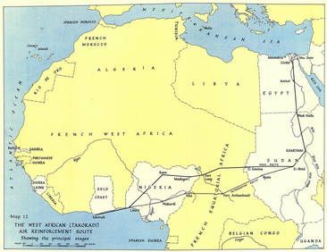
West Africa WW2 Nigeria Sudan Egypt. Takoradi air reinforcement route 1954 mapJasper524.5(9.9k)See Sold PriceFeb 28, 2024
Carte de la Haute et de la Basse Guinée. Gulf of Guinea Africa. BONNE 1780 mapJasper524.5(9.9k)See Sold PriceFeb 28, 2024
Afrique Ancienne. Ancient North Africa. MALTE-BRUN c1871 old antique map chartJasper524.5(9.9k)See Sold PriceFeb 28, 2024
Partie Occidentale de l'Ancien Continent… W Africa Macaronesia. BONNE 1780 mapJasper524.5(9.9k)See Sold PriceFeb 28, 2024
OLD ILLUSTRATED 1902 CROSS-COVERED LANDS JOURNEY TO CALCUTTA, INDIA, 2 VOLUMESNY Elizabeth 4.2(86)See Sold PriceMar 03, 2024


![[New Orleans Map] (1 of 1)](https://p1.liveauctioneers.com/268/50498/23773542_1_x.jpg?height=282&quality=70&version=1390496908)