Sold1932 Reprint map of Napa California, US Geological1932 Reprint map of Napa California, US Geological survey 20" x 15 1/2"See Sold Price
SoldMap reprint after Moses PittFramed map on metallic paper, ''Nova Totius Terrarum...,'' 20th century reprint of 17th century engraving after Moses Pitt, overall: 18.25''h x 22.25''wSee Sold Price
SoldMAP OF NORTH AND SOUTH CAROLINA 1825 REPRINTVintage Reprint Map of North and South Carolina 1825 by H.S. Stanner. Reprint was published in Kitty Hawk NC in 1967 by Lewis & Clark Explorer Map Ltd. Professionally framed and matted, measures 21 3/See Sold Price
SoldHarmonia Macrocosmica Atlas Map Set [Cosmos]The 1963 Map Reprint set with title Harmonia Macrocosmica Atlas. In VG/EX-EX+ condition, and includes 10 maps and one title page measuring 18.5-in. x 22.5-in sheet size. Housed in original paper portfSee Sold Price
SoldHarmonia Macrocosmica Atlas Map Set [Cosmos]The 1963 Map Reprint set with title Harmonia Macrocosmica Atlas. In VG/EX-EX+ condition, and includes 12 maps and one title page (scuffed) measuring 18.5-in. x 22.5-in sheet size. Also included is a bSee Sold Price
SoldLarge Framed MapLarge framed reprint map "PLANTATIONS / ON THE / MISSISSIPPI RIVER". Overall 56 3/4" x 34 1/2".See Sold Price
SoldVintage Map of Nantucket 1838 ReprintVintage Map of Nantucket 1838 Reprint, "Map of the Island of Nantucket, including Tuckernuck. Surveyed by Wm. Mitchell 1838" 8 in. x 11 in. Overall 13.75 in. x 16.5 in. Dimensions: 8 in. x 11 in. OverSee Sold Price
SoldAustralasia.- New Zealand.- Craik (John Lillie) The NewAustralasia.- New Zealand.- [Craik (John Lillie)] The New Zealanders, reprint, map, illustrations, original green cloth, spine gilt and slightly faded, [1847] § West of England Board of the New ZSee Sold Price
Sold1963 Harmonia Macrocosmica Atlas Map SetThe 1963 Map Reprint set with title Harmonia Macrocosmica Atlas. Mint in Folio, includes 12 maps and one title page measuring 18.5 in. x 22.5 in sheet size. Housed in original portfolio, these maps weSee Sold Price
SoldRobert Morden (c1650-1703) British. "Hampshire", Map,Robert Morden (c1650-1703) British. "Hampshire", Map, Reprint 1720, 15" x 18".See Sold Price
SoldLot 10+ Vintage Maps Of Upstate NY & NJLot 10+ Vintage Maps Of Upstate NY & NJ. A mixed set of vintage collectible maps and some blue prints. Maps are creased at edges and some discoloration. Largest measures approx 43 inches x 32.5 inchesSee Sold Price
SoldFramed South Carolina Inland Navigation MapFramed South Carolina Inland Navigation Map reprint 1968 publish by H. Parker. 30 1/4" x 21 3/4"See Sold Price
SoldHONDIUS 'NOVA TOTIUS TERRARUM' H/C MAP ENGRAVINGHand-colored 'Nova Totius Terrarum Orbis Geographica ac Hydrographica Tabula' engraved map reprint of the 1635 original by Willem Janszoon Blaeu (Dutch, 1571-1638), published by Hendrik Hondius. MeasuSee Sold Price
Bicentennial reprint, Martenet's Map of Cecil CounBicentennial reprint, Martenet's Map of Cecil County, Maryland from the coast and original surveys, by Simon J Martenet, Baltimore, Maryland, 1858, image 39" squareSee Sold Price
SoldSix framed chromolithographs of European city mapSix framed chromolithographs of European city maps 1960 reprint, braun & hogenberg, germany, 1586 19 3/4 x 14 in. (visible size not including frame)See Sold Price
NANTUCKET MAP AFTER EWERFramed reprint --Historical Map of Nantucket by Rev. FC Ewer 1869. Image size 14 x 22 inches.See Sold Price
Early Map of DominicaHigh Quality Reprint of Map by Sayer and Bennett London 1775. Hand colored, printed for Barre Publishers in 1968. Dominica from an Actual Survey Completed in the year 1773 Originally Part of The West-See Sold Price
Sold1969 BUZZ ALDRIN SIGNED LANDING SITE SKETCH MAPOriginal Aldrin signature in black marker with 'Apollo 11' inscribed below on a reprint site map. Pristine.See Sold Price
SoldGettysburg Battlefield Map, T. Ditterline, 1863, PGettysburg Battlefield Map, T. Ditterline, 1863, Plus Lot of 2, including map and reprint of a Sketch of the Battles of Gettysburg. 16 x 19.5 in. chromolithographed map, originally issued with pamphSee Sold Price
SoldMap Nouvelle Carte ReprintRussian Map with Alaska. Early reproduction of 1758 original. Lined paper.See Sold Price
SoldFramed Map of Seneca Falls, NYReprint of a map of Seneca Falls, NY. Parsons and Atwater, Endicott & Co. - Print Beekman St. NY. Dimensions: 30" H x 36" W; See Sold Price
Sold(WASHINGTON, D.C.) Arnold, E. G. Topographical Map of(WASHINGTON, D.C.) Arnold, E. G. Topographical Map of the Original District of Columbia and Environs. [1902 reprint.] Color-photolithographed map after Arnold's rare 1862 original. 29¾x32½ iSee Sold Price
SoldSix Unframed MapsFive Harper's Weekly Civil War maps and a 1971 reprint of a 1759 map of City of New Orleans and rivers, together with floor plans for a six floor building.From the private collection of Roulhac ToledaSee Sold Price
SoldTwo Antique Regional MapsTwo Antique Regional Mapsas follows: circa 1900 reprint of A Map of the Country Between Albemarle Sound and Lake Erie..., from Thomas Jefferson's 1787 Notes on the State of Virginia, the sheet laid toSee Sold Price
Map: A 17thC engraved and hand coloured map of Bedfordshire after Robert Morden. Approx. 12 1/2" xClaydon Auctioneers Ltd4.3(125)See Sold PriceFeb 26, 2024
Map: An 18thC engraved map of Bedfordshire titled An Accurate Map of the County of Bedford DividedClaydon Auctioneers Ltd4.3(125)See Sold PriceFeb 26, 2024
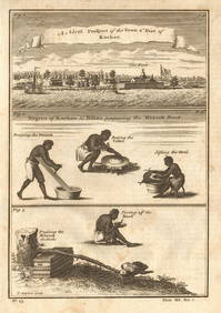
Guinea-Bissau Cacheu town Fortaleza de São José da Amura Preparing cassava 1745Jasper524.5(9.9k)See Sold PriceFeb 28, 2024
Nigeria & Chad. French West & Equatorial Africa. Cameroon. TIMES 1956 old mapJasper524.5(9.9k)See Sold PriceFeb 28, 2024
Africa. French Equatorial Africa. Rhodesia. Belgian Congo. TIMES 1956 old mapJasper524.5(9.9k)See Sold PriceFeb 28, 2024
Morocco Algeria. French & Spanish West Africa. Sahara sand dunes. TIMES 1956 mapJasper524.5(9.9k)See Sold PriceFeb 28, 2024
AFRICA. Antiqua; Rome Carthage, start Punic War 1908 old antique map chartJasper524.5(9.9k)See Sold PriceFeb 28, 2024
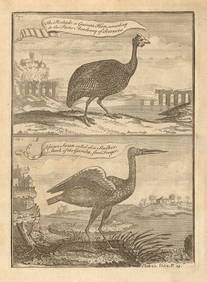
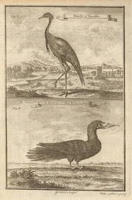
Pintado or Guinea-Hen. African Swan, or Gambian Stork. West African birds 1745Jasper524.5(9.9k)See Sold PriceFeb 28, 2024
SOUTHERN AFRICA. Congo British/Portuguese/German East Africa Rhodesia 1912 mapJasper524.5(9.9k)See Sold PriceFeb 28, 2024
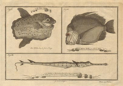
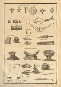
Ocean sunfish. Opah Moonfish. Orsie Petinbuaba Filefish. West African Fish 1745Jasper524.5(9.9k)See Sold PriceFeb 28, 2024
Central & East Africa. Zanzibar Tanganyika Rhodesia Congo. TIMES 1956 old mapJasper524.5(9.9k)See Sold PriceFeb 28, 2024
AFRICA. European Possessions in Central; map of Zanzibar 1907 old antiqueJasper524.5(9.9k)See Sold PriceFeb 28, 2024
West African fruit. Kola nut. Guava fruit. Kalabash Calabash tree 1745 printJasper524.5(9.9k)See Sold PriceFeb 28, 2024
Gambian birds. Monoceros. A bird with four wings. CHILD 1745 old antique printJasper524.5(9.9k)See Sold PriceFeb 28, 2024
Pre-SECOND WORLD WAR AFRICA. European colonies & German mandates 1942 old mapJasper524.5(9.9k)See Sold PriceFeb 28, 2024
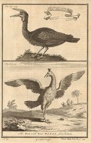
West African Birds. Crane Demoiselle. Alcatrazi or Mad-Bird. Albatross 1745Jasper524.5(9.9k)See Sold PriceFeb 28, 2024
MAGHREB. North Africa. Marocco Algeria and Tunis. BLACKIE 1886 old antique mapJasper524.5(9.9k)See Sold PriceFeb 28, 2024
COLONIAL CENTRAL AFRICA. Kenya Tanzania Belgian Congo Angola. JOHNSTON 1912 mapJasper524.5(9.9k)See Sold PriceFeb 28, 2024
Young Crocodile, drawn in London October 1739. Sea toad. Cuttlefish. SCHLEY 1747Jasper524.5(9.9k)See Sold PriceFeb 28, 2024
French West Africa. Gold Coast. Sahara desert sand dunes. TIMES 1956 mapJasper524.5(9.9k)See Sold PriceFeb 28, 2024
AFRICA. French North Africa and Morocco 1907 old antique map plan chartJasper524.5(9.9k)See Sold PriceFeb 28, 2024
COLONIAL CENTRAL AFRICA. Kenya Tanzania Belgian Congo Angola. JOHNSTON 1913 mapJasper524.5(9.9k)See Sold PriceFeb 28, 2024
EARLY COLONIAL WEST AFRICA. Empires of Sokoto Gando Mas.Tribes.Fellatah 1886 mapJasper524.5(9.9k)See Sold PriceFeb 28, 2024
West Africa gold trinkets worn as spells and utensils. jewels ornaments 1745Jasper524.5(9.9k)See Sold PriceFeb 28, 2024


![Harmonia Macrocosmica Atlas Map Set [Cosmos] (1 of 14)](https://p1.liveauctioneers.com/5755/147592/74586064_1_x.jpg?height=282&quality=70&version=1565306622)
![Harmonia Macrocosmica Atlas Map Set [Cosmos] (1 of 19)](https://p1.liveauctioneers.com/5755/154409/77936384_1_x.jpg?height=282&quality=70&version=1573094011)