Sold1932 Reprint map of Napa California, US Geological1932 Reprint map of Napa California, US Geological survey 20" x 15 1/2"See Sold Price
Thomas Johnston 1952 reprint Map of BostonFirst Map of Boston drawn by John Bonner and engraved by Thomas Johnston in 1728, reproduced in collotype by The Meriden Gravure Company from a copy owned by The Boston Athenaeum in 1952, 11.5 x 14.5See Sold Price
Sold(1781-Dated) New York Rev War Map Reprint c 1870Historic Maps Rare Early New York Revolutionary War Era Map Reprint (1781-Dated) New York Revolutionary War Map, c. 1870 Early Hand-colored Reprint, Placed Upon A 20” x 12” Wooden Presentation MouSee Sold Price
Sold1967 Pirates of the Caribbean concept art map reprint.1967 Pirates of the Caribbean concept art map reprint. Created by Sam McKim at the Pirate event at Disneyland in 2000 and given to registrants. 18 x 30” (full bleed; no border).See Sold Price
SoldMAP OF NORTH AND SOUTH CAROLINA 1825 REPRINTVintage Reprint Map of North and South Carolina 1825 by H.S. Stanner. Reprint was published in Kitty Hawk NC in 1967 by Lewis & Clark Explorer Map Ltd. Professionally framed and matted, measures 21 3/See Sold Price
SoldHarmonia Macrocosmica Atlas Map Set [Cosmos]The 1963 Map Reprint set with title Harmonia Macrocosmica Atlas. In VG/EX-EX+ condition, and includes 10 maps and one title page measuring 18.5-in. x 22.5-in sheet size. Housed in original paper portfSee Sold Price
SoldHarmonia Macrocosmica Atlas Map Set [Cosmos]The 1963 Map Reprint set with title Harmonia Macrocosmica Atlas. In VG/EX-EX+ condition, and includes 12 maps and one title page (scuffed) measuring 18.5-in. x 22.5-in sheet size. Also included is a bSee Sold Price
SoldLarge Framed MapLarge framed reprint map "PLANTATIONS / ON THE / MISSISSIPPI RIVER". Overall 56 3/4" x 34 1/2".See Sold Price
SoldLot 10+ Vintage Maps Of Upstate NY & NJLot 10+ Vintage Maps Of Upstate NY & NJ. A mixed set of vintage collectible maps and some blue prints. Maps are creased at edges and some discoloration. Largest measures approx 43 inches x 32.5 inchesSee Sold Price
SoldFramed South Carolina Inland Navigation MapFramed South Carolina Inland Navigation Map reprint 1968 publish by H. Parker. 30 1/4" x 21 3/4"See Sold Price
SoldA MAP OF THE PROVINCE OF SOUTH CAROLINA 1773A reprint map of the Province of South Carolina with all the Rivers, Creeks, Bays, Inlets, Islands, Inland Navigation, Soundings, Time of High Water on the Sea Coast, Roads, Marshes, Ferry, Bridges, SSee Sold Price
SoldLorimer.Gazetteer..Persian Gulf,9v,rept,1986Lorimer (J.G.) Gazetteer of the Persian Gulf, Oman and Central Arabia,9 vol. including box of maps, facsimile reprint, 19 folding maps and genealogical tables loose in drop-back box, originalSee Sold Price
SoldFramed Map of Seneca Falls, NYReprint of a map of Seneca Falls, NY. Parsons and Atwater, Endicott & Co. - Print Beekman St. NY. Dimensions: 30" H x 36" W; See Sold Price
Sold(WASHINGTON, D.C.) Arnold, E. G. Topographical Map of(WASHINGTON, D.C.) Arnold, E. G. Topographical Map of the Original District of Columbia and Environs. [1902 reprint.] Color-photolithographed map after Arnold's rare 1862 original. 29¾x32½ iSee Sold Price
Map of Bahrain from 1825A reprint of the map of Bahrain and the western coast of the Qatari peninsula, drawn by British navigator George Brooks. This map was one of the first drawn by English navigators to determine the deptSee Sold Price
SoldLOT OF 4 PICTURES; 3 MAPS & NYCR TRAIN PRINTLOT OF 4 PICTURES; 3 MAPS & PATERSON N.J TRAIN PRINT, THE 3 MAPS ARE OF THE PARIS FRANCE TRANSPORTATION SYSTEM ,REPRINTED FROM 1800'S MAPS CIRCA 1960'SSee Sold Price
SoldDisturnell's Treaty Map of the West 1847The map that was part of the Guadalupe Hildago Treaty in Southwestern boundaries. Stagecoach Press, Santa Fe (1965) (reprint with pullout map)See Sold Price
SoldMap, Robert de Vaugondy, Orbis VetusRobert de Vaugondy, "Orbis Vetus," 1752 (later reprint), copper engraving map with hand-coloring, depicting double hemisphere, overall (framed): 26"h x 34.5"wSee Sold Price
Sold MAP/LITHOGRPH - Original (NOT A REPRINT) (1944)MAP/LITHOGRPH - Original (NOT A REPRINT) (1944) Military Map Bureau of Naval Personnel Training Aids (Dept of Navy) / U.S. Government Printing Office, Nav War Map No. 3 / WORLD WAR 2 IN THE NORSee Sold Price
SoldAntique Copy of Willem Blaeu World Map,Antique Copy of Willem Blaeu World Map, 19th c. reprint of 17th c. original, paper watermarked by French manufacturer Anson & Montgolfier. Appears to be hand-colored, but not examined out of frame. DOSee Sold Price
SoldTWO ANTIQUE BENTWOOD EASELS & MAP PRINTSEasels measure approx. 21 1/8" w x 55 3/4" h. Maps are vintage reproductions of the World & Europe compliments of Sanka Coffee.See Sold Price
SoldUS MILITARY COLD WAR ERA MAPS PRINTS & POSTER LOTUS MILITARY COLD WAR ERA MAPS PRINTS & POSTER LOT US Military Cold War era maps, prints and posters lot. Topographical, road, vegetation and other data. Maps are of various locations such as Fort BragSee Sold Price
SoldOLD BIRDSEYE NANTUCKET MAP1948 reprint of an 1881 map BIRDSEYE VIE OF NANTUCKET by Lincoln of Hingham MA 19.5 x 28.5 image size (stains).See Sold Price
SoldEuropePublication Date: 8/23/1914 Title: Europe Cartographer: POATES, L. L. ENGR. CO. Publisher: BOSTON SUNDAY POST Height: 13.1 Width: 14.5 Unusual full color reprint of a Poates map on the front page of tSee Sold Price
Map: A 17thC engraved and hand coloured map of Bedfordshire after Robert Morden. Approx. 12 1/2" xClaydon Auctioneers Ltd4.3(125)See Sold PriceFeb 26, 2024
Map: An 18thC engraved map of Bedfordshire titled An Accurate Map of the County of Bedford DividedClaydon Auctioneers Ltd4.3(125)See Sold PriceFeb 26, 2024
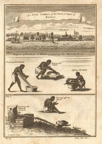
Guinea-Bissau Cacheu town Fortaleza de São José da Amura Preparing cassava 1745Jasper524.5(9.9k)See Sold PriceFeb 28, 2024
Nigeria & Chad. French West & Equatorial Africa. Cameroon. TIMES 1956 old mapJasper524.5(9.9k)See Sold PriceFeb 28, 2024
Africa. French Equatorial Africa. Rhodesia. Belgian Congo. TIMES 1956 old mapJasper524.5(9.9k)See Sold PriceFeb 28, 2024
Morocco Algeria. French & Spanish West Africa. Sahara sand dunes. TIMES 1956 mapJasper524.5(9.9k)See Sold PriceFeb 28, 2024
AFRICA. Antiqua; Rome Carthage, start Punic War 1908 old antique map chartJasper524.5(9.9k)See Sold PriceFeb 28, 2024
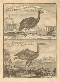
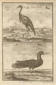
Pintado or Guinea-Hen. African Swan, or Gambian Stork. West African birds 1745Jasper524.5(9.9k)See Sold PriceFeb 28, 2024
SOUTHERN AFRICA. Congo British/Portuguese/German East Africa Rhodesia 1912 mapJasper524.5(9.9k)See Sold PriceFeb 28, 2024
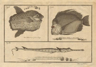
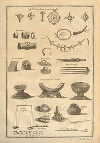
Ocean sunfish. Opah Moonfish. Orsie Petinbuaba Filefish. West African Fish 1745Jasper524.5(9.9k)See Sold PriceFeb 28, 2024
Central & East Africa. Zanzibar Tanganyika Rhodesia Congo. TIMES 1956 old mapJasper524.5(9.9k)See Sold PriceFeb 28, 2024
AFRICA. European Possessions in Central; map of Zanzibar 1907 old antiqueJasper524.5(9.9k)See Sold PriceFeb 28, 2024
West African fruit. Kola nut. Guava fruit. Kalabash Calabash tree 1745 printJasper524.5(9.9k)See Sold PriceFeb 28, 2024
Gambian birds. Monoceros. A bird with four wings. CHILD 1745 old antique printJasper524.5(9.9k)See Sold PriceFeb 28, 2024
Pre-SECOND WORLD WAR AFRICA. European colonies & German mandates 1942 old mapJasper524.5(9.9k)See Sold PriceFeb 28, 2024
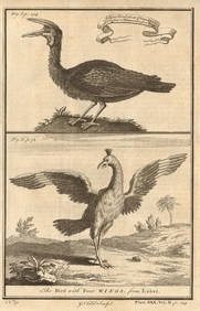
West African Birds. Crane Demoiselle. Alcatrazi or Mad-Bird. Albatross 1745Jasper524.5(9.9k)See Sold PriceFeb 28, 2024
MAGHREB. North Africa. Marocco Algeria and Tunis. BLACKIE 1886 old antique mapJasper524.5(9.9k)See Sold PriceFeb 28, 2024
COLONIAL CENTRAL AFRICA. Kenya Tanzania Belgian Congo Angola. JOHNSTON 1912 mapJasper524.5(9.9k)See Sold PriceFeb 28, 2024
Young Crocodile, drawn in London October 1739. Sea toad. Cuttlefish. SCHLEY 1747Jasper524.5(9.9k)See Sold PriceFeb 28, 2024
French West Africa. Gold Coast. Sahara desert sand dunes. TIMES 1956 mapJasper524.5(9.9k)See Sold PriceFeb 28, 2024
AFRICA. French North Africa and Morocco 1907 old antique map plan chartJasper524.5(9.9k)See Sold PriceFeb 28, 2024
COLONIAL CENTRAL AFRICA. Kenya Tanzania Belgian Congo Angola. JOHNSTON 1913 mapJasper524.5(9.9k)See Sold PriceFeb 28, 2024
EARLY COLONIAL WEST AFRICA. Empires of Sokoto Gando Mas.Tribes.Fellatah 1886 mapJasper524.5(9.9k)See Sold PriceFeb 28, 2024
West Africa gold trinkets worn as spells and utensils. jewels ornaments 1745Jasper524.5(9.9k)See Sold PriceFeb 28, 2024


![Harmonia Macrocosmica Atlas Map Set [Cosmos] (1 of 14)](https://p1.liveauctioneers.com/5755/147592/74586064_1_x.jpg?height=282&quality=70&version=1565306622)
![Harmonia Macrocosmica Atlas Map Set [Cosmos] (1 of 19)](https://p1.liveauctioneers.com/5755/154409/77936384_1_x.jpg?height=282&quality=70&version=1573094011)