Sold(MAP) WEIGEL, CHRISTOPHER. Scena Historiarum Occid(MAP) WEIGEL, CHRISTOPHER Scena Historiarum Occidentalis Quinti Seculi P.N. Chr. in qua Imperii Romanorum & Accolarum Barbarorum Status Sistitur accurate. Nuremburg, n.d. (c. 1720) Hand-colored engravSee Sold Price
1720 Galia Transalpina in fuas quatuor Provinicas.By: Christopher Weigel Date: 1720 (published) Nuremberg. Dimensions: 12 x 15 inches ( 30.48 x 38.1 cm ) This is an authentic antique map France, by Christopher Weigel. It was published in Nuremberg foSee Sold Price
SoldWeigel map of Americas Calif. and islandTitle: Novi Orbis sive Totius Americae cum Adiacentibus Insulis Nova Exhibitio Author: Weigel, Christopher Description: Copper-engraved map, hand-colored. 27x34 cm. (10½x13½").Map of North and SouthSee Sold Price
SoldMap of Jerusalem of Melchizedek and the City of DavidIerusalem aus den Schriften Iosephi ganz neu vorgestellt von I. H. Coccejo. Christ. Weigel excud. Imaginary, schematic map of Jerusalem of Melchizedek and the City of David. From: Weigel Christopher tSee Sold Price
Sold[1820 MAP]39. [1820 MAP] Colorful map of Sicily, ca. 1820, by Christopher Weigel, The Elder. Copperplate engraving published in Nurnberg by Kohler. Original coloring, small cartouche present. Tip of Africa is aSee Sold Price
SoldÆgyptus Inferior sive DeltaAuthor: Weigel, Christopher, the Elder Description: Copper-engraved map, original hand-coloring. 30.7x40 cm. (12x15-3/4"). The heavily populated Nile delta in classical times, with a cartouche depictiSee Sold Price
Sold[1720 MAP]38. [1720 MAP] Original hand-colored map depicting Germany, Denmark and southern Sweden by Christopher Weigel, The Elder, 1720, published in Nuremberg by Johann Kohler, overall 18½"x14¼". Large cartSee Sold Price
Sold1720 GERMAN MAP BY WEIGEL THE ELDER93. 1720 GERMAN MAP Original hand-colored map depicting Germany, Denmark and southern Sweden by Christopher Weigel, The Elder, 1720, published in Nuremberg by Johann Kohler, overall 18½"x14¼". LargeSee Sold Price
SoldMost Recent Map of La Louisiane, ca. 1720"Novissima Tabula Regionis Ludoviciana Gallice dictae la Louisiane (Most Recent Map of the French Louisiana Region called La Louisiane)" by Christopher Weigel (German, 1654-1725), hand-colored engraveSee Sold Price
1720 Gallia Cisalpina et Italia PropriaGallia Cisalpina et Italia Propria By: Christopher Weigel Date: 1720 (published) Nuremberg Dimensions: 12.25 x 15.5 inches (31.1 x 39.4 cm) This is an authentic antique map of northern Italy and CorsiSee Sold Price
1720 Ora Baiana et Puteolana...By: Christopher Weigel Date: 1720 (published) Nuremberg Dimensions: 11.25 x 15 inches (28.6 x 38.1 cm) This is an authentic antique map of the Bay of Naples. It was published in Nuremberg for the atlaSee Sold Price
SoldI.H. Coccejo / Weigel: Map of Jerusalem, 1720Map: Jerusalem, "Ierusalem aus den Schrifften Iosephi" Cartographer: I.H. Coccejo. / Weigel Place & Date: Nuremberg / 1720 Size: 16 5/8" x 13" Condition: original color; overall age toning and minor sSee Sold Price
Sold1734 Weigel Map of French and British Pocessions inTitle: 1734 Weigel Map of French and British Pocessions in America -- Novissima Tabula Regionis Ludovicianae Gallice dicta la Louisiane… Cartographer: C Weigel Year / Place: 1734, Nurnberg Map DimenSee Sold Price
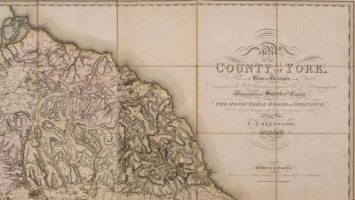
SoldYorkshire.- Greenwood (Christopher) Map of the County of York, made on the Basis of Triangles in theNO RESERVE Yorkshire.- Greenwood (Christopher) Map of the County of York, made on the Basis of Triangles in the County, determined by Lieut. Col. Wm. Mudge, county map in six sections, with calligraphSee Sold Price
SoldSomerset.- Greenwood (Christopher) Map of the County ofNO RESERVE Somerset.- Greenwood (Christopher) Map of the County of Somersetshire, from Actual Survey Made in the Years 1820 & 1821, county map with vignette of Wells Cathedral in the lower left, decorSee Sold Price
SoldMaps, Christoph Weigel [Group of 6][Group of 6 maps by Christoph Weigel, hand-color, all measuring approx. 15" x 12", all 18th c.] **** 1: Ducatus Carnioliae. 3" cut to lower left margin, 1" closed tear to lower margin, vertical creaseSee Sold Price
SoldAn Atlas of England and Wales. 1979. 192/500.[Atlas Facsimile]. AN ATLAS OF ENGLAND AND WALES: The Maps of Christopher Saxton Engraved 1574-1578. Introduction by R. V. Tooley. Lon: Collectors Library of Fine Art, 1979. Placed in at front endpapeSee Sold Price
SoldWeigel: Antique Map of Italy, 1720Title/Content of Map: Italy by Weigel Date Printed: c1720 Cartographer: C. Weigel Material/Medium: Paper Size: 14" x 17 1/2" Hand colored copperplate engraved. Published in Nuremberg. Please note thatSee Sold Price
J.N. Bellin: Map of St. Christopher Island, 1758Carte Réduite De L'Isle De Saint Christophe is a highly detailed large-scale engraved map of St. Christopher island (a.k.a. St. Kitts) with topography, several place names, and a beautiful title cartSee Sold Price
SoldWeigel: Antique Map of Israelite Exodus Encampment 1720Map: Castra metatio oder Zeichnung der Lager-Ordnung, nach welcher die XII. Stämme des Volks Gottes Cartographer: Weigel Place & Date: Nuremberg / 1720s Size: 16 5/8" x 13" Condition: original color;See Sold Price
SoldWeigel: Antique Map of Sardinia, 1720Title/Content of Map: Regni Sardiniae Descriptio Cartographer: Weigel Place & Date: Nuremberg / 1720s Size: 12 1/2" x 15 3/4" Condition: wash color; very light overall age toning A beautifully designeSee Sold Price
SoldWeigel: Antique Map of Guadeloupe & Martinique, 1718Map: Insulae Antillae Franciae Superiores cum vicinis insulis ex commentarus manuscriptis et variis navigantium observationibus descriptae a Petitio Geometra Regio Cartographer: Weigel Place & Date: NSee Sold Price
SoldWeigel: Antique Map of Lesser Antilles, 1718Map: Insulae Antillae Franciae Inferiores Cartographer: Weigel Place & Date: Nurnberg / 1718 Size: 14 1/8" x 12 7/8" Condition: delicate wash and outline color; light overall age toning A dramatic GerSee Sold Price
Weigel: Antique Map of Southern French Antilles, 1718Insulae Antillae Franciae Inferiores A dramatic German early 18th-century map of lower French Antilles, including St. Lucia, St. Vincent and the Grenadines, Grenada, and Barbados, based on "written coSee Sold Price
Central Railroad of New Jersey Map of Sandy Hook Route-ca. 1903JM Hobby Supply and Railroad Artifact Auctions4.4(127)See Sold PriceFeb 24, 2024
Rand McNally/Santa Fe Railroad Map of Iowa-1912JM Hobby Supply and Railroad Artifact Auctions4.4(127)See Sold PriceFeb 24, 2024
17TH C. WORLD MAP BY NICOLAES VISSCHER (NETHERLANDS, 1618-1709)Thomaston Place Auction Galleries4.4(393)See Sold PriceFeb 24, 2024
LATE 17TH C. FRENCH MAP OF THE NEW WORLD BY ALEXIS-HUBERT JAILLOT (1632-1712)Thomaston Place Auction Galleries4.4(393)See Sold PriceFeb 24, 2024
18TH C. ANTIQUE MAP: FRENCH & INDIAN WAR, FRAMEDThomaston Place Auction Galleries4.4(393)See Sold PriceFeb 24, 2024
NICOLAES VISSCHER (NETHERLANDS, 1618-1709) MAP OF THE NEW WORLDThomaston Place Auction Galleries4.4(393)See Sold PriceFeb 24, 2024
CHRISTOPHER "CHRIS" HUNTINGTON (ME/CAN, 1938 - )Thomaston Place Auction Galleries4.4(393)See Sold PriceFeb 25, 2024
CHRISTOPHER BLOSSOM (Connecticut, 1956-), "Colonial Schooner Halifax"., Oil on canvas, 17" x 27".Eldred's4.7(419)See Sold PriceFeb 27, 2024
Keith Haring - Ink on New York Map, Best Buddies, Inscribed, Signed, and DatedSapphire Auction Gallery4(67)See Sold PriceMar 02, 2024
Rand McNally Railroad Map Cabinet w/ 21 Railroad MapsRail & Road Auctions4.6(165)See Sold PriceMar 08, 2024
Putnam - First Map of the State of Ohio by Rufus PutnamTrillium Antique Prints & Rare Books4.5(32)See Sold PriceFeb 24, 2024
1750 Bowen Map of Bermuda and St. Kitts -- A New & Accurate Map of Bermudas or Sommer's Islands...Jasper524.5(9.9k)See Sold PriceFeb 27, 2024
Victorian Christopher Columbus Kerosene Floor LampGray's Auctioneers4.5(187)See Sold PriceMar 06, 2024
CURTIUS RUFUS QUINTUS, SIXTEENTH-CENTURY ELZEVIER HISTORIARUM LIBRI W/ MAP 16.33NY Elizabeth 4.2(86)See Sold PriceMar 03, 2024
Per Olof Christopher Aurivillius (1843-1928) - Set of 3 Prints - ButterfliesProverde Auctions4.3(3)See Sold PriceFeb 28, 2024
Per Olof Christopher Aurivillius (1843-1928) - Set of 3 Prints - Butterflies in SwedenProverde Auctions4.3(3)See Sold PriceFeb 28, 2024
Per Olof Christopher Aurivillius (1843-1928) - Set of 3 Prints - Butterflies - ScandinaviaProverde Auctions4.3(3)See Sold PriceFeb 28, 2024


![[1820 MAP] (1 of 1)](https://p1.liveauctioneers.com/135/375/187759_1_x.jpg?height=282&quality=70&version=1070305305)

![[1720 MAP] (1 of 1)](https://p1.liveauctioneers.com/135/375/187758_1_x.jpg?height=282&quality=70&version=1070305305)


![Maps, Christoph Weigel [Group of 6] (1 of 7)](https://p1.liveauctioneers.com/3532/79779/41533565_1_x.jpg?height=282&quality=70&version=1444167022)