SoldMap Troki Lithuania Lithuanianzemelapis "Trakai-Prienai" (Troki Preny). 1855 m. Druck u. Verlag v. C. Flemming in Glogau. Su Vokietijos karo archyvo "K. K. Kriegs archiv" antspaudu. 27 x 36 cm, popierius ant audinio. Su Nemuno upeSee Sold Price
SoldCoronelli Map Lithuania Lithuanian.Vincenzo Coronelli (1650-1718) LITUANIA .1690-1691, Venice, copper engraving hand colored. 18 1/2" x 25". Trimmed at lower margin, other margins ample.See Sold Price
Nidden map Lithuania LithuanianKursiu Nerijos zemelapis. 1 dalis. Nuo Kranto (Cranz) iki Nidos. XX a. 4 des. Wanderkarte von der Kurischen Nehrung. Blatt 1. Cranz bis Nidden. Photolith. V Bogdan Gisevius, Berlin. Islankstytas - 124See Sold Price
SoldRoad map Lithuania LithuanianLietuvos keliu zemelapis. Carte routiere de Lithuanie. Publie par l’automobile club de Lithuanie. Mastelis 1:500000. Braize Br. Lazauskas. Kaunas: Isleido Lietuvos automobiliu klubas, spausdinoSee Sold Price
SoldPhotograph Troki Lithuania LithuanianTraku pusiasalio pilies bokstas. Autorius nezinomas, 1897 m. Nuotr. (fotopop., 11,8x17). Tiketina, kad tai viena pirmuju pusiasalio pilies fotografiju.See Sold Price
SoldKatescenka Troki Lithuania LithuanianGurij Katescenka (1910-1983) Traku pilis. Apie 1963 m. Pop., bromidas 28,3 x 21,3 cmSee Sold Price
EVSTACHIVS WOLOWICZ Troki Lithuania LithuanianVilniaus vyskupo Eustachijaus Valaviciaus portretas.Lukas Kilianas (Lucas Kilian, 1579-1637). Augsburgas, 1604 m.Popierius su vandenzenkliais, vario raizinys, 20,2x13,7.irasas ovaliniame reme aplink pSee Sold Price
SoldAlytus map Lithuania Lithuanianzemelapis "Alytus-Merkine" (Olita Merecz). 1855 m. Druck u. Verlag v. C. Flemming in Glogau. Su Vokietijos karo archyvo "K. K. Kriegs archiv" antspaudu. 27 x 36 cm, popierius ant audinio. Su Nemuno upSee Sold Price
Georg Matthaus Seutter map Lithuania LithuanianGeorg Matthaus Seutter I (1678 - 17560 ir Georg Matthaus Seutter (1729 - 1760) Novisima et accuratisima MAGNI DUCATUS LITHUANIe... Apie 1740, Augsburgas, Spalvintas vario raizinys, 49 x56,7See Sold Price
Johannes Papritz map Lithuania LithuanianJohannes Papritz (1898 - 1992)Historische Kartenfolge f r das Reic skommissariat stland 1943, scale 1: 750 000, color printing,37 x 33 Riga, P.Maitnieks Kartographisches InstitutA very rare historicalSee Sold Price
SoldMap Lithuania Lithuanian KaunasPhysical map of the Western hemisphere 1939, pop, 135 x 97.5 Issued by the Press Foundation. Press-fund lithography in Kaunas.See Sold Price
Justus Dankerts map Lithuania LithuanianJustus Dankerts (1635 - 1701) Regni Poloniae et Ducatus Lithuaniae, Voliniae, Podoliae, Vcrainiae, Prussiae et Curlandie ... Amsterdam, Dankerts, 1695, spalvintas vario raizinys, 49 x 58See Sold Price
Coronelli map Lithuania LithuanianVincenzo Maria Coronelli (1650 - 1718) LITUANIA Dedicata All’Illustrissimo Signore Gio Pietro Caualli Segretario della Sereniscima Republicae di Venetia apresco L’Eccelentiscimo Sigr CauSee Sold Price
SoldGerman topographic maps Lithuania LithuanianVokisku topografiniu zemelapiu, vaizduojanciu Lietuvos teritorija, rinkinys. 10 vienetu. Karte des Westlichen Russlands. Kartographische Abteilung d. Konigl. Preussisch Landesaufhnahme, Berlin, 1914-1See Sold Price
SoldTroki photo Lithuania LithuanianTraku apskr. zasliu girininkijos Kruonio valstybinio misko sargai. 1902 m. geguzes 1 d. Nuotr. (fotopop., 16,2 x 23) prikl. ant kart. (24,2x31,2). KP: nuotraukos aprasymas rusu k.See Sold Price
Troki Jerzy Schafner Lithuania LithuanianTraku salos pilies griuvesiai. 1829 m. litografija, Jurgio safnerio (Jerzy Schafner) litografijos dirbtuves (Varsuva). 1829, pop., litograf., 7,5 x 11,5 (lakstas 10 x 15,8 cm). Uzrasas po atvaizdu: "RSee Sold Price
SoldStefan Plater Zyberk Troki Lithuanian LithuaniaStefan Plater-Zyberk (1891-1943) Traku ezerai Nuotrauka(fotopop., 23x40 ) su pasportu 30x45. Nuotraukos pasparto AD kampe Fot. Photo-Plat Stefan Plater-Zyberk (1891-1943) buvo vienas is garsiausiu tarSee Sold Price
SoldLithuania Lithuanian Ozieblowski TrokiJuozapas Ozemblovskis. Kestucio pilys Trakuose. Atspausta J. Ozemblovskio litografijos spaustuveje 1843 m. Litografija, 17x22,7. Apacioje irasas: "ZAMKI KIEJSTUTA W TROKACH". Dail. J. Ozemblovskio (apSee Sold Price
Map Kaunas Kowno Vilijampole Lithuania LithuanianVilijampoles Slabada and county planMade by Panemune county land surveyor RagovskisMiddle of the XIX century, hand drawn, paper, ink, watercolour, 81 x 84. Dimensions (in cm): 81 x 84See Sold Price
SoldMap Kowno 1872 Lithuanian LithuaniaKauno gubernijos zemelapis 1876 Karta Kovenskoy gubernii. SPb.: Kartograficheskoye zavedeniye A.Il'ina, [1876]. Masshtab: 1 : 840000 (v 1 angl. dyuyme 20 verst). 1876, pop., spauda, 35,9x50,9See Sold Price
Radziwill Lithuania Lithuanian BelarusDuke Mikolaj Krzysztof Radziwll 1613 m. Lietuvos Map of the Grand Duchy and the Dnieper River.Amsterdam, 1631-1647 m. Watercolor copper engraving, 75,5 x 74, 75,5 x 33 Willem Janszoon Blaeu and Joan BSee Sold Price
SoldVilna Lithuania Lithuanian Zawadzkago[Memorial Book of Vilnius Governorate for 1858] The memorial book of the province of Vilna in 1858. Vilna: In the printing house of Osip Zawadzkago,,1858. VII, [1], 111 p.: map.See Sold Price
Georg Friederich Lotter Lithuania LithuanianGeorg Friederich Lotter (1744-1801) Magnus Ducatus Lithuania in suos Palatinatus et Castellanias divisa …, Augsburgas, Map of the Grand Duchy of Lithuania. 1780. Colored copper engraving, 49 x 5See Sold Price
SoldJakubowski Lithuania Lithuanian BelarusMap depicting the lands of the Grand Duchy of Lithuania in the 16th century. Jan Jakubowski. Mapa Wielkiego Ksiestwa Litewskiego w polowie XVI wieku. 1. Czesc polnocna. Skala 1 : 1.600.000 : objasnienSee Sold Price
Central Railroad of New Jersey Map of Sandy Hook Route-ca. 1903JM Hobby Supply and Railroad Artifact Auctions4.4(126)See Sold PriceFeb 24, 2024
Cincinnati Hamilton and Dayton RR Map -USGC 1889JM Hobby Supply and Railroad Artifact Auctions4.4(126)See Sold PriceFeb 24, 2024
Northern Pacific RR Washington and Northern Idaho Map Folder-1941JM Hobby Supply and Railroad Artifact Auctions4.4(126)See Sold PriceFeb 24, 2024
Rand McNally/Santa Fe Railroad Map of Iowa-1912JM Hobby Supply and Railroad Artifact Auctions4.4(126)See Sold PriceFeb 24, 2024
17TH C. WORLD MAP BY NICOLAES VISSCHER (NETHERLANDS, 1618-1709)Thomaston Place Auction Galleries4.4(389)See Sold PriceFeb 24, 2024
LATE 17TH C. FRENCH MAP OF THE NEW WORLD BY ALEXIS-HUBERT JAILLOT (1632-1712)Thomaston Place Auction Galleries4.4(389)See Sold PriceFeb 24, 2024
18TH C. ANTIQUE MAP: FRENCH & INDIAN WAR, FRAMEDThomaston Place Auction Galleries4.4(389)See Sold PriceFeb 24, 2024
NICOLAES VISSCHER (NETHERLANDS, 1618-1709) MAP OF THE NEW WORLDThomaston Place Auction Galleries4.4(389)See Sold PriceFeb 24, 2024
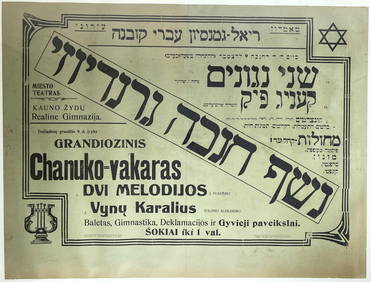
Grandiose Hanukkah Ball - Kovna Hebrew Gymnasium, 1920sLevy Auction House4.3(11)See Sold PriceFeb 27, 2024
Nova Totius Full Color Geographical World MapThe Benefit Shop Foundation Inc.4.3(2.9k)See Sold PriceFeb 28, 2024
Civil War Map, Positions of the Army of the Ohio Front oh Dalton GA Dated 1864 34"L x 24"TSwisher Bros. Auction LLC4.4(251)See Sold PriceFeb 24, 2024
Keith Haring - Ink on New York Map, Best Buddies, Inscribed, Signed, and DatedSapphire Auction Gallery4.1(67)See Sold PriceMar 02, 2024
Rand McNally Railroad Map Cabinet w/ 21 Railroad MapsRail & Road Auctions4.6(165)See Sold PriceMar 08, 2024
Willem Blaeu, Etc. 17th C. Antiquarian Maps, 2Auctions at Showplace4.6(731)See Sold PriceMar 17, 2024
Putnam - First Map of the State of Ohio by Rufus PutnamTrillium Antique Prints & Rare Books4.5(30)See Sold PriceFeb 24, 2024
De Jode, Rare, pub. 1593 - Map of Africa (Africae Vera Forma, et Situs)Trillium Antique Prints & Rare Books4.5(30)See Sold PriceFeb 24, 2024