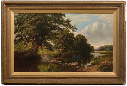
BRITISH SCHOOL, OIL ON CANVAS, RIVERSCAPE,Pridham's Auctions & Appraisals4.7(223)See Sold PriceMar 02, 2024
ATTRIBUTED THOMAS CRESWICK (1811-1869) OIL ON CANVASSoulis Auctions4.8(953)See Sold PriceFeb 24, 2024
British School, "Man Seated Outside an Estate with Show Dogs," c. 1900, H.- 23 1/2 in., W.- 33 1/4Crescent City Auction Gallery4.3(231)See Sold PriceMar 09, 2024
Fine 17th Century British Old Master Oil Painting Portrait of Nobleman in RobesJasper524.5(9.9k)See Sold PriceFeb 28, 2024
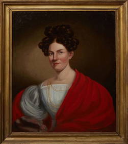
British School, "Portrait of a Lady with White Regency Dress and Red Shawl," 19th c., oil on canvas,Crescent City Auction Gallery4.3(231)See Sold PriceMar 01, 2024
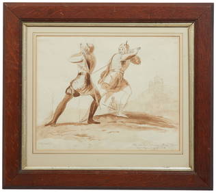
British School, "Valentines Day: The Combat Between Henry Wynd and Torquil of the Oak," late 19thCrescent City Auction Gallery4.3(231)See Sold PriceMar 01, 2024
British School, "Crashing Waves at Dusk," 19th c., H.- 9 in., W.- 16 in., Framed- H.- 13 1/2 in.,Crescent City Auction Gallery4.3(231)See Sold PriceMar 08, 2024
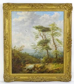
British School, "Children Playing on a Road by a Home in the Woods," H.- 11 3/4 in., W.- 14 3/4 in.,Crescent City Auction Gallery4.3(231)See Sold PriceMar 08, 2024
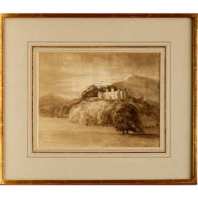
ILLEGIBLY SIGNED (BRITISH SCHOOL, 19TH CENTURY).Clarke Auction Gallery4.6(557)See Sold PriceMar 10, 2024
British School Cavalry Officer Watercolor On PaperAuctions at Showplace4.6(740)See Sold PriceApr 16, 2024
William Mellor (1851-1931), British School, Oil on canvas, A woodland landscape scene with figuresClaydon Auctioneers Ltd4.3(125)See Sold PriceFeb 26, 2024
Map, The Map of the Circles of the Upper Rhine andBritish School (18th century), "The Map of the Circles of the Upper Rhine and Lower Rhine," copper engraved map with hand coloring, published by R. Wilkinson February 1794, London (possibly later prinSee Sold Price
SoldMap, The Map of the Circles of the Upper Rhine andBritish School (18th century), "The Map of the Circles of the Upper Rhine and Lower Rhine," copper engraved map with hand coloring, published by R. Wilkinson February 1794, London (possibly later prinSee Sold Price
1794 Wilkinson Map of Central Germany, Rhine, Moselle and Main River Area s-- A Map of the CirclesTitle: 1794 Wilkinson Map of Central Germany, Rhine, Moselle and Main River Area s-- A Map of the Circles of The Upper Rhine, Lower Rhine & Franconia, Drawn from the Best Authorities Cartographer: R WSee Sold Price
1794 Wilkinson Map of Central Germany, Rhine, Moselle and Main River Area s-- A Map of the CirclesTitle: 1794 Wilkinson Map of Central Germany, Rhine, Moselle and Main River Area s-- A Map of the Circles of The Upper Rhine, Lower Rhine & Franconia, Drawn from the Best Authorities Cartographer: R WSee Sold Price
1794 Wilkinson Map of Central Germany, Rhine, MoselleTitle: 1794 Wilkinson Map of Central Germany, Rhine, Moselle and Main River Area s-- A Map of the Circles of The Upper Rhine, Lower Rhine & Franconia, Drawn from the Best Authorities Cartographer: R WSee Sold Price
1794 Wilkinson Map of Central Germany, Rhine, MoselleTitle: 1794 Wilkinson Map of Central Germany, Rhine, Moselle and Main River Area s-- A Map of the Circles of The Upper Rhine, Lower Rhine & Franconia, Drawn from the Best Authorities Cartographer: R WSee Sold Price
1799 Cary Map of Central and West Germany-- A New Map of the Circles of the Upper and Lower RhineTitle: 1799 Cary Map of Central and West Germany-- A New Map of the Circles of the Upper and Lower Rhine from the Latest Authorities Cartographer: J Cary Year / Place: 1799, London Map Dimension (in.)See Sold Price
Kitchin Map of GermanyKITCHIN, Thomas (1718-1784). The circles of Lower Rhine, Franconia, Swabia, and Bavaria, with the southern parts, of the circles of upper Rhine and Saxony, the western parts of Bohemia and of the circSee Sold Price
Li Circoli dell' Alto, e Basso Reno Western Germany. Rheinland. ZATTA 1783 mapTITLE/CONTENT OF MAP: 'Li Circoli dell' Alto, e Basso Reno di nuova projezione' "The Upper and Lower Rhenish Circles", or Circles of the Upper and Lower Rhine. Western Germany, roughly corresponding tSee Sold Price
Nuova Carta de Circolo del Reno [&] ducato di Lorena'.TITLE/CONTENT OF MAP: 'Nuova Carta de Circolo Superiore ed Inferiore del Reno annesso il Ducato di Lorena [New chart of the circle of the Upper and Lower Rhine annexed by the Duchy of Lorraine]' The mSee Sold Price
Antique Map - Europe - Upper Rhine - Heraldry of Germany - Frankfurt - HomannTitle/Content: Antique Map - Europe - Upper Rhine - Heraldry of Germany - Frankfurt - Homann Date: 1730 Material: Paper Dimensions: 24” x 21” inches / 62 cm x 53 cm Description: Unusual anSee Sold Price
Buffier. Map of upper Rhine. France. 1765.Print from steel engraving titled „Les Deux cercles du Haut etbas Rhin“.Author/compiler – Buffier.Published in Paris, France in M. DCC. LXV. – 1765.Notes: Septentrion/Orient/Midy/Occident, pagSee Sold Price
Antique Map - Europe - Upper Rhine - Heraldry of Germany - Frankfurt - HomannUnusual and attractive large antique engraved map "Circuli Rhenani Superioris… Joh. Baptista Homanni Norimbergae" by Homann Heirs, originates from "Maior Atlas Scholasticus ex Triginta Sex GenerSee Sold Price
3 Maps incl: KARTE VON DEM LAUFE DES FLUSSES...[Canada/Central Europe/Russia] 3 Maps incl. Bellin "Map Of The Course Of The St. Laurence River From Its Estuary To Quebec" and "Map of the [Range] of the Upper Rhine." Under glass. Not examined out oSee Sold Price
SoldMaps of Mexico, the Upper and Lower Rhine, and ColombiaMaps of Mexico, the Upper and Lower Rhine, and Colombia. John Hamilton. [from] The Edinburgh Geographical and Historical Atlas. Edinburgh: Daniel Lizars, [1831]. Each map is engraved and hand-colored,See Sold Price
Upper Rhine Vosges Alsace Lorraine Baden N Switzerland.TITLE/CONTENT OF MAP: France/Germany/Switzerland: 'Sheet VIII' The map covers the region between Worms to the north, Stuttgart to the east, Lucerne to the south and Châlons-en-Champagne to the west.See Sold Price
Tombleson, William 1834 Map of the River Rhine"Tombleson's Upper Rhine" Showing Germany and Switzerland. Steel Engraved Map Published 1832-34, London for "Tombleson's Upper Rhine" Edited by William Gray Fearnside. Illustrated by William TomblesonSee Sold Price
Tombleson, William 1834 Map of the River Rhine"Tombleson's Upper Rhine" Showing Germany and Switzerland. Steel Engraved Map Published 1832-34, London for "Tombleson's Upper Rhine" Edited by William Gray Fearnside. Illustrated by William TomblesonSee Sold Price
Tombleson, William 1834 Map of the River Rhine"Tombleson's Upper Rhine" Showing Germany and Switzerland. Steel Engraved Map Published 1832-34, London for "Tombleson's Upper Rhine" Edited by William Gray Fearnside. Illustrated by William TomblesonSee Sold Price
Upper Rhine Vosges Alsace Lorraine Baden N Switzerland.TITLE/CONTENT OF MAP: France/Germany/Switzerland: 'Sheet VIII' The map covers the region between Worms to the north, Stuttgart to the east, Lucerne to the south and Châlons-en-Champagne to the west.See Sold Price
Tobias Conrad Lotter (1717-1777), "Superioris atque inferioris Alsatiae" (Map of Upper and Lowercolored copper engraving map on paper, unsigned, around 1750, figurative title cartouche with mile pointer at the top left, map of Alsace with the course of the Rhine from Eglisau to Philippsburg, AugSee Sold Price
Parte Settentrionale del… Alta Sassonia. Brandenburg Pomerania. ZATTA 1783 mapTITLE/CONTENT OF MAP: 'Parte Settentrionale del Circolo dell' Alta Sassonia di nuova projezione' "The northern part of the Circle of Upper Saxony". Brandeburg and Pomerania in Germany and Poland. TheSee Sold Price
Parte Meridionale del Circolo dell' Alta Sassonia. Thuringia. ZATTA 1783 mapTITLE/CONTENT OF MAP: 'Parte Meridionale del Circolo dell' Alta Sassonia di nuova projezione' "The southern part of the Circle of Upper Saxony". The western part of the modern German state of Saxony,See Sold Price
Parte Settentrionale del Alta Sassonia. BrandenburgTITLE/CONTENT OF MAP: 'Parte Settentrionale del Circolo dell' Alta Sassonia di nuova projezione' "The northern part of the Circle of Upper Saxony". Brandeburg and Pomerania in Germany and Poland. TheSee Sold Price
LATE 17TH C. FRENCH MAP OF THE NEW WORLD BY ALEXIS-HUBERT JAILLOT (1632-1712)Thomaston Place Auction Galleries4.4(393)See Sold PriceFeb 24, 2024
MATTHEWS c1856 Map Of Upper Canada Ontario Indian Land Agency Divisions Scarce!Luis Porretta Fine Arts4.3(10)See Sold PriceMar 02, 2024
Pair of Early Railroad Maps - 1862 Pittsburgh, Ft. Wayne & Chicago Railway and 1873 PennsylvaniaRail & Road Auctions4.6(165)See Sold PriceMar 07, 2024
18th Century Hess Germany Hand colored Engraved MapGlobal Auctions Company4.3(36)See Sold PriceMar 03, 2024
[CHICAGO]. Rare Pre-Fire Illinois Map: “Blanchard’s Map of ...Potter & Potter Auctions4.6(545)See Sold PriceMar 07, 2024
1738 BIBLE in DUTCH ILLUSTRATED w/ MAPS antique MASSIVE FOLIO BIBLIAJasper524.5(9.9k)See Sold PriceFeb 27, 2024
Royaumes, Etats et Pays de la Haute Guinée. Gulf of Guinea. BONNE 1788 old mapJasper524.5(9.9k)See Sold PriceFeb 28, 2024
NILE VALLEY. Upper & Lower. Egypt Sinai Nubia Sudan Abyssinia. BLACKIE 1886 mapJasper524.5(9.9k)See Sold PriceFeb 28, 2024
Colonial & French West Africa. Gold Coast Dahomey Upper Volta. TIMES 1922 mapJasper524.5(9.9k)See Sold PriceFeb 28, 2024
NORTH AFRICA. Morocco Algeria Tunis Tunisia Egypt. Cairo. BARTHOLOMEW 1912 mapJasper524.5(9.9k)See Sold PriceFeb 28, 2024
NORTH AFRICA. Morocco Algeria Tunis Tunisia Egypt. Cairo. BARTHOLOMEW 1901 mapJasper524.5(9.9k)See Sold PriceFeb 28, 2024
NILE VALLEY. Upper & Lower. Egypt Sinai Nubia Sudan Abyssinia. BLACKIE 1882 mapJasper524.5(9.9k)See Sold PriceFeb 28, 2024
Cooke, George 1801 Antique Map. Germany divided into CirclesAlbion Auctions4.7(341)See Sold PriceMar 01, 2024
Vintage 1920s Rand McNally Auto Trails MapThe Benefit Shop Foundation Inc.4.3(2.9k)See Sold PriceMar 20, 2024
6 pcs Vintage Paper Maps. Vancouver Island, British Columbia. Upper Elk Creek Sheet. See pics.Crawford Family Auctions LLC4.6(122)See Sold PriceMay 25, 2024


![Nuova Carta de Circolo del Reno [&] ducato di Lorena'. (1 of 2)](https://p1.liveauctioneers.com/5584/122553/62377206_1_x.jpg?height=282&quality=70&version=1527639612)


![[CHICAGO]. Rare Pre-Fire Illinois Map: “Blanchard’s Map of ... (1 of 2)](https://p1.liveauctioneers.com/928/318880/171361260_1_x.jpg?height=282&quality=70&version=1707501302)


