SoldMap "The Continuation of the Road from London to theMap "The Continuation of the Road from London to the Holy Land," "From Chester to Holy Head," by John Ogilvy, Esq., His Majesties Cosmographer," 15" x 19 3/4", edge damage, as-is.See Sold Price
SoldA monochromatic strip map 'The Continuation of the RoadA monochromatic strip map 'The Continuation of the Road from London to the Lands-end' by J. Ogleby. 34 x 48cm.See Sold Price
Sold1 piece. Hand Colored Engraved Map. Ogilby, John.1 piece. Hand Colored Engraved Map. Ogilby, John. The Continuation of the Road from London to Flambrugh." [London], [1675]. 13 3/4 x 17 1/2 inches; 249 x 445 mm. Clean. Framed."See Sold Price
SoldOgilby (John) - A Group of Strip Road Maps,The Road from London to Shrewsbury; The Continuation Road from London to Holy-head; The Road from London to Flamourough Head; and 5 others including 1 duplicate , 8 engraved strip road maps, 4 with haSee Sold Price
SoldJohn Ogilby, The Continuation of the Road from LondonJohn Ogilby, The Continuation of the Road from London to Barwick, beginning at Stilton and extending to Tuxford, handcoloured, A road map of London to Worthing, published by E Mogg 1814, and another hSee Sold Price
SoldCornwall.- - A mixed group of road maps and smallcomprising 2 strip maps by Ogilby, The Continuation of the Extended Road from Barstable to Truro, and The Continuation of the Road from London to the Lands-End, with a reduced version of the latter bySee Sold Price
SoldPAIR OF CIRCA 1675 ROAD MAPS BY JOHN OGILBYThe Road from CHELMSFORD and the Continuation of the Road from LONDON to the Lands End Part two. Both by John Ogilby. Hand coloring appears early. We happily provide seamless in-house packing and shipSee Sold Price
SoldOgilby. Continuation of...Road From London. c.1675[England] Ogilby, John. “The Continuation of ye Road From London to Aberistwith, Plate of Second Commencing Islip com Oxford & Extending to Bramyard com Hereford.” London, c.1675. EngravedSee Sold Price
SoldGardner, Thomas — Zwei englische StraßenkartenGardner, Thomas — Two English road maps ''The Road from Oxford to Chichester'' (plate 81) und ''The Continuation of the Road from London S. Davids'' (plate 17). Coloured copper engravings fromSee Sold Price
SoldOgilby (John) The continuation of the Road from LoOgilby (John) The continuation of the Road from London to Carlisle...from Garstang...to Carlisle,hand-coloured engraved strip road map with cartouche, rather browned, 340 x 430mm., [c.1670] §See Sold Price
Sold[Ogilby (J] The Road from London to Barwick-. [Ogilby (John)] The Continuation of the Road from London to Barwick, engraved strip road map from Newcastle to Berwick, decorative cartouche, with hand-colouring, 325 x 445mm., [c.1670], anSee Sold Price
SoldOgilby (John) Road from London to BristolOgilby (John) The Continuation of the Road from London to Bristol,decorative title cartouche, engraved strip road map with hand-colouring, 330 x 440mm., central vertical fold, light offsettingSee Sold Price
SoldOgilby (J) London to the Lands-EndOgilby (John) The Continuation of The Road from London to the Lands-End,engraved strip road map from Axminster to Plymouth, decorative cartouche, with hand-colouring, 340 x 500mm., faint brownSee Sold Price
SoldOgilby, The Road from Carlisle...to Barwick;Ogilby (John) The Road from Carlisle...to Barwick;The Continuation of the Road from London to Barwick, decorative title cartouches, 2 engraved strip road maps, with hand-colouring, 325 x 445mmSee Sold Price
SoldGROUP OF ANTIQUE MAPSIncluded are: An early Mercator map of Burgundy; in German. The Road from London to Pool by Thomas Gardner; Continuation of the Road form York to West-Chester by Thomas Gardner; circa 1866 map of NebrSee Sold Price
SoldOgilby strip map of English roadHeading: (Great Britain) Author: Ogilby, John Title: The Continuation of the Extended Road from Buckingham to Bridgnorth in Com Salop… Place Published: London Publisher: Date Published: 1675<See Sold Price
Early 18thc Engraved Maps, Road to LondonOriginal early 18th century engravings, Emanuel Bowen ( 1714 - 1767 ) "Map of the Road from London to Dover in Kent". 7 1/4" X 9 3/4" along with "Map of the Road from London to Hith." 7 1/4" X 4 3/4".See Sold Price
Early 18thc Engraved Maps, Road to LondonOriginal early 18th century engravings, Emanuel Bowen ( 1714 - 1767 ) "Map of the Road from London to Dover in Kent". 7 1/4" X 9 3/4" along with "Map of the Road from London to Hith." 7 1/4" X 4 3/4".See Sold Price
Early 18thc Engraved Maps, Road to LondonOriginal early 18th century engravings, Emanuel Bowen ( 1714 - 1767 ) "Map of the Road from London to Dover in Kent". 7 1/4" X 9 3/4" along with "Map of the Road from London to Hith." 7 1/4" X 4 3/4".See Sold Price
SoldEarly 18thc Engraved Maps, Road to LondonOriginal early 18th century engravings, Emanuel Bowen ( 1714 - 1767 ) "Map of the Road from London to Dover in Kent". 7 1/4" X 9 3/4" along with "Map of the Road from London to Hith." 7 1/4" X 4 3/4".See Sold Price
Early 18thc Engraved Maps, Road to LondonOriginal early 18th century engravings, Emanuel Bowen ( 1714 - 1767 ) "Map of the Road from London to Dover in Kent". 7 1/4" X 9 3/4" along with "Map of the Road from London to Hith." 7 1/4" X 4 3/4".See Sold Price
Early 18thc Engraved Maps, Road to LondonOriginal early 18th century engravings, Emanuel Bowen ( 1714 - 1767 ) "Map of the Road from London to Dover in Kent". 7 1/4" X 9 3/4" along with "Map of the Road from London to Hith." 7 1/4" X 4 3/4".See Sold Price
Early 18thc Engraved Maps, Road to LondonOriginal early 18th century engravings, Emanuel Bowen ( 1714 - 1767 ) "Map of the Road from London to Dover in Kent". 7 1/4" X 9 3/4" along with "Map of the Road from London to Hith." 7 1/4" X 4 3/4".See Sold Price
Early 18thc Engraved Maps, Road to LondonOriginal early 18th century engravings, Emanuel Bowen ( 1714 - 1767 ) "Map of the Road from London to Dover in Kent". 7 1/4" X 9 3/4" along with "Map of the Road from London to Hith." 7 1/4" X 4 3/4".See Sold Price
1892 Adams and Bowles New Road Map of the State of New YorkJM Hobby Supply and Railroad Artifact Auctions4.4(126)See Sold PriceFeb 24, 2024
FLYING A TOURING SERVICE U.S. ROAD MAPS TIN WALL DISPLAY.Dan Morphy Auctions4.2(1.3k)See Sold PriceFeb 25, 2024
17TH C. ENGLISH LINEAR MAP BY OGILBY, FRAMEDThomaston Place Auction Galleries4.4(386)See Sold PriceFeb 24, 2024
Westland Oil Company North Dakota Road MapCheck the Oil Promotions, LLC4.6(275)See Sold PriceFeb 25, 2024
An "Official Disneyland Road Map" Richfield Brochure.Van Eaton Galleries4.6(99)See Sold PriceMar 02, 2024
Keith Haring Artwork Signed on a Shell Oil New York Road Map 18 in. x 24 in.Donny Malone Auctions4.5(1.7k)See Sold PriceMar 04, 2024
Paterson & Mogg 1822 Pair of British Road Maps. Isle of Thanet & WightAlbion Auctions4.6(336)See Sold PriceMar 01, 2024
Paterson & Mogg 1822 Pair of British Road Maps. Rye, Eastbourne, SouthamptonAlbion Auctions4.6(336)See Sold PriceMar 01, 2024
Paterson & Mogg 1822 Pair of British Road Maps. Deal, Hythe, Shoreham, ChichesterAlbion Auctions4.6(336)See Sold PriceMar 01, 2024
A 14ct Gold Half Hunter Pocket Watch by John Myers & Co Ltd of Westminster Bridge Road, London and CHannam's Auctioneers Ltd4.3(386)See Sold PriceFeb 27, 2024
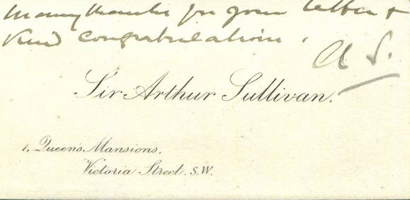
SULLIVAN ARTHUR: (1842-1900)International Autograph Auctions Europe S.L.4.5(52)See Sold PriceMar 13, 2024
CHRISTIE ETHEL: (1898-1952)International Autograph Auctions Europe S.L.4.5(52)See Sold PriceMar 13, 2024
OLD ILLUSTRATED 1902 CROSS-COVERED LANDS JOURNEY TO CALCUTTA, INDIA, 2 VOLUMESNY Elizabeth 4.3(84)See Sold PriceMar 03, 2024


![[Ogilby (J] The Road from London to Barwick (1 of 1)](https://p1.liveauctioneers.com/410/3027/1300487_1_x.jpg?height=282&quality=70)