ATLAS of ANTIENT GEOGRAPHY by SAMUEL BUTLER 1843John McInnis Auctioneers,LLC4.6(504)See Sold PriceFeb 24, 2024
18TH C. ANTIQUE MAP: FRENCH & INDIAN WAR, FRAMEDThomaston Place Auction Galleries4.4(389)See Sold PriceFeb 24, 2024
Rand McNally Railroad Map Cabinet w/ 21 Railroad MapsRail & Road Auctions4.6(165)See Sold PriceMar 08, 2024
Keith Haring - Ink on New York Map, Best Buddies, Inscribed, Signed, and DatedSapphire Auction Gallery4.1(67)See Sold PriceMar 02, 2024
LATE 17TH C. FRENCH MAP OF THE NEW WORLD BY ALEXIS-HUBERT JAILLOT (1632-1712)Thomaston Place Auction Galleries4.4(389)See Sold PriceFeb 24, 2024
Central Railroad of New Jersey Map of Sandy Hook Route-ca. 1903JM Hobby Supply and Railroad Artifact Auctions4.4(126)See Sold PriceFeb 24, 2024
Lot of Six Mixed Atlas Box Cars-HO Scale-New in BoxJM Hobby Supply and Railroad Artifact Auctions4.4(126)See Sold PriceFeb 25, 2024
Rand McNally/Santa Fe Railroad Map of Iowa-1912JM Hobby Supply and Railroad Artifact Auctions4.4(126)See Sold PriceFeb 24, 2024
NICOLAES VISSCHER (NETHERLANDS, 1618-1709) MAP OF THE NEW WORLDThomaston Place Auction Galleries4.4(389)See Sold PriceFeb 24, 2024
17TH C. WORLD MAP BY NICOLAES VISSCHER (NETHERLANDS, 1618-1709)Thomaston Place Auction Galleries4.4(389)See Sold PriceFeb 24, 2024
Lot of Six Mixed Atlas Cabooses-HO Scale-New in BoxJM Hobby Supply and Railroad Artifact Auctions4.4(126)See Sold PriceFeb 25, 2024
Porcacchi: Antique Map of Sicily, 1620TITLE/CONTENT OF MAP: 'Descrittione dell' Isola di Sicilia [Description of the island of Sicily]' The map depicts the Italian Mediterranean island of Sicily. The map is orientated towards the north. DSee Sold Price
Descrittione dell' Isola di Sicilia. PORCACCHI. Sicily Italy 1590 old mapTITLE/CONTENT OF MAP: Descrittione dell' Isola di Sicilia [Description of the island of Sicily] The map depicts the Italian Mediterranean island of Sicily. The map is orientated towards the north. DATSee Sold Price
SoldCuba Map, Porcacchi, 1572Cuba Map. Porcacchi's well-known map of Cuba (with Jamaica and part of Hispaniola), from his 1572 Isolario, The World's Most Famous Islands. A delightful cartouche, a compass rose and fanciful marineSee Sold Price
Sold(MAP, SICILY) DE WIT, FREDERICK. Insula sive regnumMAP, SICILY by DE WIT, FREDERICK, Insula sive regnum Siciliae urbibus praecipuis exornatum. Amsterdam, circa 1680. Hand-colored engraved map of Sicily. With inset plans of Messina, Milazzo and PalermoSee Sold Price
SoldAntique Map : Sicily - 1807Antique Map : Sicily - 1807 from Geographie Antique Size : 16.25" x 10.75'"See Sold Price
(MAP, SICILY) DE WIT, FREDERICK. Insula sive regnum(MAP, SICILY) DE WIT, FREDERICK Insula sive regnum Siciliae urbibus praecipuis exornatum. Amsterdam, circa 1680. Hand-colored engraved map of Sicily. With inset plans of Messina, Milazzo and Palermo,See Sold Price
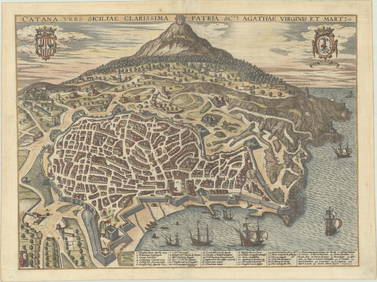
MAP - Sicily, Italy. OrteliusSicily, Italy. Abraham Ortelius, Siciliae Veteris Typus, 1584 (published). Hand Color. Stunning map with three decorative cartouches and a large inset of the harbor and city of Syracuse. Ortelius baseSee Sold Price
ITALY general map. Sicily Malta Sardinia Corsica.TITLE/CONTENT OF MAP: 'ITALY, General map including Sicily, Malta, Sardinia, and Corsica' DATE PRINTED: 1874 IMAGE SIZE: Approx 41.5 x 34.5cm, 16.25 x 13.75 inches (Large) TYPE: Antique steel engravedSee Sold Price
SoldMAP, Sicily, Italy, HalmaSicily, Italy. Francois Halma, Sicilien Verdeelt in Zyne Drie Valleyen, 1705 (published). Hand Color. Superb little map of Sicily showing its political divisions and fine detail of topography, cities,See Sold Price
MAP, Sicily, Italy, BochartiSicily, Italy. Samuelis Bocharti, Sicilia Insula, from Geographiae Sacrae Pars Prior Phaleg..., 1651 (circa). Hand Color. This is a very uncommon map from the work of the Protestant minister and orienSee Sold Price
MAP - Sicily, Italy. Mercator/HondiusSicily, Italy. Mercator/Hondius, Sicilia, 1610 (published). Hand Color. Delightful small map of Sicily filled with topographical detail and place names. A smoking Mt. Etna is depicted at right. The maSee Sold Price
"Map Sicily, 1893, From the book "La Patria" by GustavoMap Sicily, 1893, From the book "La Patria" by Gustavo Stdepictingorello. Cm 26x35 etching color lithograph. With wooden frame walnut color 42x52 cm. Very good condition.See Sold Price
MAP - Sicily, Italy. MercatorSicily, Italy. Mercator/Hondius, Siciliae Regnum, 1619 (published). Hand Color. This is a strikingly graphic map of the Kingdom of Sicily, and the first plate to appear in Mercator's Atlas. The map isSee Sold Price
MAP, Sicily, Italy, WitSicily, Italy. Frederick de Wit, Insula sive Regnum Siciliae Urbibus Praecipuis Exornatum, 1680 (circa). Hand Color. This fine and embellished map of Sicily is filled with detail including towns, citiSee Sold Price
MAP - Sicily, Italy. BochartiSicily, Italy. Samuelis Bocharti, Sicilia Insula, 1651 (circa). Hand Color. This is a very uncommon map from the work of the Protestant minister and oriental scholar Samuel Bochart (1599-1667). Both tSee Sold Price
MAP - Sicily, Italy. MercatorSicily, Italy. Mercator/Hondius, Siciliae Regnum, 1619 (published). Hand Color. This is a strikingly graphic map of the Kingdom of Sicily, and the first plate to appear in Mercator's Atlas. The map isSee Sold Price
SoldMAP, Sicily, Italy, BochartiSicily, Italy. Samuelis Bocharti, Sicilia Insula, 1651 (circa). Hand Color. This is a very uncommon map from the work of the Protestant minister and oriental scholar Samuel Bochart (1599-1667). Both tSee Sold Price
'Map Sicily, 1893, From the book 'La Patria' by Gustavo'Map Sicily, 1893, From the book 'La Patria' by Gustavo Stdepictingorello. Cm 26x35 etching color lithograph. With wooden frame walnut color 42x52 cm. Very good condition.'See Sold Price
MAP - Sicily, Italy & Malta. Weimar Geo.Sicily, Italy & Malta. Weimar Geographisches Institut, Charte von Sicilien und Malta nach den Bewahrtesten Hulfsmitteln Neu Entworfen und Gezeichnet von F. Goetze, 1801 (dated). Hand Color. The largeSee Sold Price
SoldSicily & Sardinia, Malta with sea monstersTitle/Content of Map: Sicily & Sardinia, Malta with sea monsters Date: 1598/99. Cartographer: Ruscelli Size: 11x9”. Provenance: Venice. Reserve: $165.00 Shipping: Domestic: Free shipping to anywherSee Sold Price
Sicily.Title/Content of Map: Sicily. Date: 1576-1590. Cartographer: By Porcacchi Size: 8x12”. Provenance: Republic of Venice Decorated with three sea monsters, compass rose, and a beautiful title cartoucheSee Sold Price
Sicily.Title/Content of Map: Sicily. Date: 1576-1590. Cartographer: Porcacchi Size: 8x12”. Provenance: Republic of Venice Decorated with three sea monsters, compass rose, and a beautiful title cartouche. RSee Sold Price
Sicily.Title/Content of Map: Sicily. Date: 1576-1590. Cartographer: By Porcacchi Material/Medium: Copper plate engraved Size: 8x12”. Provenance: Republic of Venice Additional Info: Decorated with three seaSee Sold Price
Sold1747 1ed Ancient GREECE Macedonia Alexander the Great1747 1ed Ancient GREECE Macedonia Alexander the Great MAPS Sicily Crete Rhodes The “Universal History” is a mid-18th-century history of the world. Written by numerous authors and contributors, thiSee Sold Price
Central Railroad of New Jersey Map of Sandy Hook Route-ca. 1903JM Hobby Supply and Railroad Artifact Auctions4.4(126)See Sold PriceFeb 24, 2024
Rand McNally/Santa Fe Railroad Map of Iowa-1912JM Hobby Supply and Railroad Artifact Auctions4.4(126)See Sold PriceFeb 24, 2024
17TH C. WORLD MAP BY NICOLAES VISSCHER (NETHERLANDS, 1618-1709)Thomaston Place Auction Galleries4.4(389)See Sold PriceFeb 24, 2024
LATE 17TH C. FRENCH MAP OF THE NEW WORLD BY ALEXIS-HUBERT JAILLOT (1632-1712)Thomaston Place Auction Galleries4.4(389)See Sold PriceFeb 24, 2024
18TH C. ANTIQUE MAP: FRENCH & INDIAN WAR, FRAMEDThomaston Place Auction Galleries4.4(389)See Sold PriceFeb 24, 2024
NICOLAES VISSCHER (NETHERLANDS, 1618-1709) MAP OF THE NEW WORLDThomaston Place Auction Galleries4.4(389)See Sold PriceFeb 24, 2024
Nova Totius Full Color Geographical World MapThe Benefit Shop Foundation Inc.4.3(2.9k)See Sold PriceFeb 28, 2024
Keith Haring - Ink on New York Map, Best Buddies, Inscribed, Signed, and DatedSapphire Auction Gallery4.1(67)See Sold PriceMar 02, 2024
Rand McNally Railroad Map Cabinet w/ 21 Railroad MapsRail & Road Auctions4.6(165)See Sold PriceMar 08, 2024
Putnam - First Map of the State of Ohio by Rufus PutnamTrillium Antique Prints & Rare Books4.5(30)See Sold PriceFeb 24, 2024
Cooke, George 1801 Antique Map. Italy, Sicily, Sardinia & CorsicaAlbion Auctions4.6(341)See Sold PriceMar 01, 2024