ATLAS of ANTIENT GEOGRAPHY by SAMUEL BUTLER 1843John McInnis Auctioneers,LLC4.6(502)See Sold PriceFeb 24, 2024
18TH C. ANTIQUE MAP: FRENCH & INDIAN WAR, FRAMEDThomaston Place Auction Galleries4.4(386)See Sold PriceFeb 24, 2024
Rand McNally Railroad Map Cabinet w/ 21 Railroad MapsRail & Road Auctions4.6(165)See Sold PriceMar 08, 2024
Keith Haring - Ink on New York Map, Best Buddies, Inscribed, Signed, and DatedSapphire Auction Gallery4(67)See Sold PriceMar 02, 2024
LATE 17TH C. FRENCH MAP OF THE NEW WORLD BY ALEXIS-HUBERT JAILLOT (1632-1712)Thomaston Place Auction Galleries4.4(386)See Sold PriceFeb 24, 2024
Central Railroad of New Jersey Map of Sandy Hook Route-ca. 1903JM Hobby Supply and Railroad Artifact Auctions4.4(126)See Sold PriceFeb 24, 2024
Lot of Six Mixed Atlas Box Cars-HO Scale-New in BoxJM Hobby Supply and Railroad Artifact Auctions4.4(126)See Sold PriceFeb 25, 2024
Rand McNally/Santa Fe Railroad Map of Iowa-1912JM Hobby Supply and Railroad Artifact Auctions4.4(126)See Sold PriceFeb 24, 2024
NICOLAES VISSCHER (NETHERLANDS, 1618-1709) MAP OF THE NEW WORLDThomaston Place Auction Galleries4.4(386)See Sold PriceFeb 24, 2024
17TH C. WORLD MAP BY NICOLAES VISSCHER (NETHERLANDS, 1618-1709)Thomaston Place Auction Galleries4.4(386)See Sold PriceFeb 24, 2024
Lot of Six Mixed Atlas Cabooses-HO Scale-New in BoxJM Hobby Supply and Railroad Artifact Auctions4.4(126)See Sold PriceFeb 25, 2024
MAP - Sicily, Italy & Malta. Weimar Geo.Sicily, Italy & Malta. Weimar Geographisches Institut, Charte von Sicilien und Malta nach den Bewahrtesten Hulfsmitteln Neu Entworfen und Gezeichnet von F. Goetze, 1801 (dated). Hand Color. The largeSee Sold Price
ITALY general map. Sicily Malta Sardinia Corsica.TITLE/CONTENT OF MAP: 'ITALY, General map including Sicily, Malta, Sardinia, and Corsica' DATE PRINTED: 1874 IMAGE SIZE: Approx 41.5 x 34.5cm, 16.25 x 13.75 inches (Large) TYPE: Antique steel engravedSee Sold Price
Pr Large Maps Italy Malta etc By Weiland 1820Weiland, C. F. SUDLICHES ITALIEN KONIGEICHI BEIDER SICILIEN NEBST DE INSELN MALTA, GOZO U COMINO. ( LARGE MAP DATED 1820 OF SOUTHERN ITALY, SICILY, MALTA, GOZO AND COMINO ) 26" x 21". Published in GerSee Sold Price
SoldC. F. Weiland map of Italy, MaltaCartographer: Carl Ferdinand Weiland Title: Italien entworfen und gezeichnet Subject: Italy, Malta Published: Weimar: Geographisches Institut Date: 1839 Description: Map showing the sovereign states oSee Sold Price
Italy General map including Sicily, Malta, Sardinia,Title/Content of Map: Italy General map including Sicily, Malta, Sardinia, Corsica &c. Date: 1852-01-01 Publisher: S.D.U.K. Charles Knight Size: 15.5Height - 12.25Width Published under the superintendSee Sold Price
Colton: Antique Map of Malta, Sicily & Sardinia, 1861Map: Malta and Islands of Italy (Sicily & Sardinia) Date Printed: 1861 Cartographer: J.H. Colton Material/Medium: Paper Size: 17 1/2" x 14" Condition: Excellent Printed in New York. Hand colored steelSee Sold Price
1830 SDUK Map of Sicily, Malta and Southern Tip of Italy -- Italy IIITitle: 1830 SDUK Map of Sicily, Malta and Southern Tip of Italy -- Italy III Cartographer: SDUK Year / Place: 1830, London Map Dimension (in.): 11.1 X 15 in. This is a striking map of Sicily, Malta anSee Sold Price
1830 SDUK Map of Sicily, Malta and Southern Tip of Italy -- Italy IIITitle: 1830 SDUK Map of Sicily, Malta and Southern Tip of Italy -- Italy III Cartographer: SDUK Date/Place: 1830, London Dimensions: 11.1 X 15 in. Description: This is a striking map of Sicily, MaltaSee Sold Price
SoldSDUK: Antique Map of Italy, 1845Title/Content of Map: 'ITALY IV, General map including Sicily, Malta, Sardinia, and Corsica' Date Printed: 1845 Image Size: Approx 40.5 x 34.5cm, 16 x 13.5 inches (Large) Type: Antique steel engravedSee Sold Price
SDUK: Antique Map of Italy, 1845Title/Content of Map: 'ITALY IV, General map including Sicily, Malta, Sardinia, and Corsica' Date Printed: 1845 Image Size: Approx 40.5 x 34.5cm, 16 x 13.5 inches (Large) Type: Antique steel engravedSee Sold Price
SDUK: Antique Map of Italy, 1845TITLE/CONTENT OF MAP: 'ITALY IV, General map including Sicily, Malta, Sardinia, and Corsica' DATE PRINTED: 1845 IMAGE SIZE: Approx 40.5 x 34.5cm, 16 x 13.5 inches (Large) TYPE: Antique steel engravedSee Sold Price
1830 SDUK Map of Roman Sicily, Malta and Southern Tip of Italy -- Ancient Italy Part III and SicilyTitle: 1830 SDUK Map of Roman Sicily, Malta and Southern Tip of Italy -- Ancient Italy Part III and Sicily Cartographer: SDUK Date/Place: 1830, London Dimensions: 11.1 X 15 in. Description: This is aSee Sold Price
1830 SDUK Map of Roman Sicily, Malta and Southern Tip of Italy -- Ancient Italy Part III and SicilyTitle: 1830 SDUK Map of Roman Sicily, Malta and Southern Tip of Italy -- Ancient Italy Part III and Sicily Cartographer: SDUK Year / Place: 1830, London Map Dimension (in.): 11.1 X 15 in. This is a stSee Sold Price
"Italia annexis insulis Sicilia, Sardinia et Corsica"Tobias Conrad Lotter. Year 1758. Map of Italy with Sardinia, Corsica, Sicily, Malta, and Menorca. The print is in good condition, slightly browned, on laid paper with watermark. Plate size 48 x 57.5 cSee Sold Price
Sold1863 JOHNSON'S MAP OF ITALYA.J. Johnson, NY, map of the newly unified Kingdom of Italy, plus Sardinia, Malta, and Sicily. Professionally matted, 23.75 x 16.5 inches.See Sold Price
Italy.- Sicily & Sardinia.- Seutter (Matthäus)Italy.- Sicily & Sardinia.- Seutter (Matthäus) Siciliae Regnum cum adjacente Insula Sardinia et maxima parte Regni Neapolitani, map of Sicily, Sardinia, Malta and parts of Corsica, South Italy anSee Sold Price
SoldItaly.- Sicily.- Anonymous. Carta della Sicilia conItaly.- Sicily.- Anonymous. Carta della Sicilia con l'antica e la moderna divisione in Valli, large detailed folding map of Sicily, including the island of Stromboli in the north and with Malta and GoSee Sold Price
SoldSICILY, CALABRIA, Malta & Gozo with original outlineTITLE/CONTENT OF MAP: 'ITALY III., South, and Sicily' The top image on the right hand side shows the entire map. To view a close up of the map showing the level of printed detail, please click on theSee Sold Price
SoldItaly.- Sicily.- Ottens (Reiner & Joshua) Insulae etItaly.- Sicily.- Ottens (Reiner & Joshua) Insulae et Regni Siciliae Novissima Tabula, map of Sicily based on the work of Guillaume de L'Isle, with inset map of Malta and Gozo, engraving with early hanSee Sold Price
SoldColton: Antique Map of Southern Italy, 1859Southern Italy with Sicily & Sardinia and insert of Malta 1859 H.J. Colton 17 1/2" x 15" Hand colored and engraved. Published in New York in Colton's 'General Atlas'. Please note that this lot has a cSee Sold Price
SoldItaly.- Homann (Johann Baptist) Regnorum Siciliae etItaly.- Homann (Johann Baptist) Regnorum Siciliae et Sardiniae nec non Melitae seu Maltae insula..., map showing Sicily, Sardinia, and Malta, with part of the northern coast of Africa, with an inset vSee Sold Price
SoldIslands of Italy and Malta. 1762 by Homann HeirsTitle: Islands of Italy and Malta. 1762 by Homann Heirs Date/Period: 1762 Materials: Copperplate engraved Size: 24 x 20 1/2" Shows Sicily, Sardinia, Corsica and Malta, along with the southern boot ofSee Sold Price
SoldSidney Hall: Antique Map of South Italy, 1856Title/Content of Map: 'Italy, south part [inset: Malta and its dependencies]' Sardinia Sicily. Date Printed: 1856 Image Size: Approx 28.5 x 41.0cm, 11.25 x 16 inches (Large) Type: Antique atlas map wiSee Sold Price
SoldSDUK: Pre-unification Italy, 1852The general map of Italy from the SDUK atlas, including Sicily, Malta, Sardinia, and Corsica, plus a list of the various pre-unification Italian states, their size, population (as of 1828), and populaSee Sold Price
EARLY 18TH C. MAP OF ITALY, FRAMEDThomaston Place Auction Galleries4.4(386)See Sold PriceFeb 24, 2024
MAP - PIETER SCHENK / VALK / JANSSEN Hand Colored superb Map Central Italy c1702Luis Porretta Fine Arts4.3(10)See Sold PriceMar 02, 2024
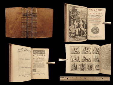
1699 Jean Dumont VOYAGES in France Italy Germany ROME Malta Turkey Ottoman 3vSchilb Antiquarian Rare Books4.8(421)See Sold PriceMar 31, 2024
Illustrated Sabbath Cloth - Holy Sites of Eretz IsraelLevy Auction House4.3(11)See Sold PriceFeb 27, 2024
De Jode, Rare, pub. 1593 - Map of Italy (Italiae Totius Orbis olim Domatricis Nova ExactissTrillium Antique Prints & Rare Books4.5(30)See Sold PriceFeb 24, 2024
A quantity of World War II / Two military ephemera to include assorted 1940s newspapers pages toClaydon Auctioneers Ltd4.3(125)See Sold PriceFeb 26, 2024
Italy & Sicily 1847 Lot of 4 Steel Engravings by PayneAlbion Auctions4.6(336)See Sold PriceMar 07, 2024
Cooke, George 1801 Antique Map. Italy, Sicily, Sardinia & CorsicaAlbion Auctions4.6(336)See Sold PriceMar 01, 2024
Conrad Gessner (1516 - 1565) - Set of 4 Bird Prints - Hortvlana, Vt vvlgo in Italy - De HorioneProverde Auctions4.3(3)See Sold PriceFeb 28, 2024
Louis Eustache Audot - Set of 9 Prints - Palermo Cattedrale - Catania - ItalyProverde Auctions4.3(3)See Sold PriceFeb 28, 2024
Joseph Meyer - Set of 50 Prints - Views of Austria - Germany - Italy - Sweden - France - CzechProverde Auctions4.3(3)See Sold PriceFeb 28, 2024
Joseph Meyer - Set of 50 Prints - Views of Austria - Germany - Italy - Sweden - France - UnitedProverde Auctions4.3(3)See Sold PriceFeb 28, 2024