ATLAS of ANTIENT GEOGRAPHY by SAMUEL BUTLER 1843John McInnis Auctioneers,LLC4.5(505)See Sold PriceFeb 24, 2024
18TH C. ANTIQUE MAP: FRENCH & INDIAN WAR, FRAMEDThomaston Place Auction Galleries4.4(393)See Sold PriceFeb 24, 2024
Rand McNally Railroad Map Cabinet w/ 21 Railroad MapsRail & Road Auctions4.6(165)See Sold PriceMar 08, 2024
Keith Haring - Ink on New York Map, Best Buddies, Inscribed, Signed, and DatedSapphire Auction Gallery4.1(67)See Sold PriceMar 02, 2024
LATE 17TH C. FRENCH MAP OF THE NEW WORLD BY ALEXIS-HUBERT JAILLOT (1632-1712)Thomaston Place Auction Galleries4.4(393)See Sold PriceFeb 24, 2024
Central Railroad of New Jersey Map of Sandy Hook Route-ca. 1903JM Hobby Supply and Railroad Artifact Auctions4.4(127)See Sold PriceFeb 24, 2024
Lot of Six Mixed Atlas Box Cars-HO Scale-New in BoxJM Hobby Supply and Railroad Artifact Auctions4.4(127)See Sold PriceFeb 25, 2024
Rand McNally/Santa Fe Railroad Map of Iowa-1912JM Hobby Supply and Railroad Artifact Auctions4.4(127)See Sold PriceFeb 24, 2024
NICOLAES VISSCHER (NETHERLANDS, 1618-1709) MAP OF THE NEW WORLDThomaston Place Auction Galleries4.4(393)See Sold PriceFeb 24, 2024
17TH C. WORLD MAP BY NICOLAES VISSCHER (NETHERLANDS, 1618-1709)Thomaston Place Auction Galleries4.4(393)See Sold PriceFeb 24, 2024
Lot of Six Mixed Atlas Cabooses-HO Scale-New in BoxJM Hobby Supply and Railroad Artifact Auctions4.4(127)See Sold PriceFeb 25, 2024
Map Showing the Different Routes Travelled Over by theTitle: Map Showing the Different Routes Travelled Over by the Detachments of The Overland Command in The Spring of 1855 from Salt Lake City, Utah to The Bay Of San Francisco. Date: 1855 Cartographer:See Sold Price
Map Showing the Different Routes Travelled Over by theTitle: Map Showing the Different Routes Travelled Over by the Detachments of The Overland Command in The Spring of 1855 from Salt Lake City, Utah to The Bay Of San Francisco. Date: 1855 Cartographer:See Sold Price
SoldRoutes across the west 1855Heading: Author: Steptoe, E.J., Rufus Ingalls, et al. Title: Map showing the different routes travelled over by the Detachments of the Overland Command in the Spring of 1855 from Salt Lake City, UtahSee Sold Price
SoldMap of Salt Lake to S.F. route 1855Title: Map showing the different routes travelled over by the Detachments of the Overland Command in the Spring of 1855 from Salt Lake City, Utah to the Bay of San Francisco Author: [Ingalls, Rufus] DSee Sold Price
Map Showing the Routes Travelled by the Command of Maj.Map: Map Showing the Routes Travelled by the Command of Maj. E. Steen, U.S. Drags Against The Snake Indians in 1860... Publication Date: 1860 Cartographer: DIXON, JOSEPH (1834-1862) Publisher: WAR DEPSee Sold Price
Map pertaining to Major E. Steen, U.S. Dragoons againstDixon (Lieutenant, Topographical Engineers) Joseph. Map showing the routes travelled by the command of major E. Steen, U.S. Dragoons against the Snake Indians in 1860. NY Lithography by Julius Bien, 1See Sold Price
SoldMap - Major Steen, US Dragoons Snake Indians 1860Map pertaining to Major E. Steen, U.S. Dragoons against Snake Indians 1860 - Dixon (Lieutenant, Topographical Engineers) Joseph. Map showing the routes travelled by the command of Major E. Steen, U.S.See Sold Price
Map pertaining to Major E. Steen, U.S. Dragoons againstDixon (Lieutenant, Topographical Engineers) Joseph. Map showing the routes travelled by the command of major E. Steen, U.S. Dragoons against the Snake Indians in 1860. NY Lithography by Julius Bien, 1See Sold Price
SoldMap of the Overland Command C. 1855Illustrates the different routes travelled over by the detachments of the overland command in the spring of 1855 from Salt Lake City, Utah to the Bay of San Francisco. Senate Executive document No. 1,See Sold Price
19th Century Philadelphia Railroad Map.Map by Duval showing routes of 9 different railroads (as indicated by different colors) in Philadelphia area. Map measures 17" x 26" and exhibits some fold splitting.See Sold Price
SoldMap Showing Routes of the Pacific Coast SteamshipReserve Reduced! Title/Content of Map: Map Showing Routes of the Pacific Coast Steamship Company. Date: 1887-02-01 Cartographer: RAND, MCNALLY & CO. Publisher: PACIFIC COAST STEAMSHIP CO. Size: 26.75See Sold Price
Road Map Showing Route of the Pacific Highway and OtherTitle: Road Map Showing Route of the Pacific Highway and Other Chief Roads of California Publication Date: 1926 Cartographer: ANONYMOUS Publisher: PACIFIC HIGHWAY ASSOCIATION OF CALIFORNIA Size: 17.25See Sold Price
SoldVan der Aa map showing route to British coloniesTitle: 't Noorder Gedeelte van Virginie door Bartholomeus Gosnol en Martin Pringe uyt Engeland Bevaaren Author: Van der Aa, Pieter Description: Copper-engraved map. 15x23 cm. (6x9").North Atlantic andSee Sold Price
SoldPost WWII Constabulary Zone of Germany Sector MapNice color WWII Occupation era US Constabulary of Germany road / zone map showing different allied control areas. It appears to be cut down and is not dated. Well used piece with folds and some tearsSee Sold Price
1897 Rand McNally Map of Pacific Northwest -- MapTitle/Content of Map: 1897 Rand McNally Map of Pacific Northwest -- Map Showing Routes of the Pacific Coast Steamship Company Cartographer: Rand McNally Year/Place: 1897, Chicago Size: 27 X 12.6 in. TSee Sold Price
SoldRare 1850 German Emigration MapRare 1850 German Emigration Map Showing Routes to California & Oregon103. [MAP]. SMITH, J[ohn] Calvin & H[enry] S[chenck]. Tanner (after). Neueste Eisenbahn-Kanal-U. Post-Karte f&uSee Sold Price
Sold1900 California Railroad MapCalifornia. Railroad map centered roughly at Sacramento. Engraved date 1900.Steel. 4 x 4 inches. Railroad map showing routes from Oakland to Oroville, California with shorter routes connecting SacrameSee Sold Price
1897 Rand McNally Map of Pacific Northwest -- MapTitle: 1897 Rand McNally Map of Pacific Northwest -- Map Showing Routes of the Pacific Coast Steamship Company Cartographer: Rand McNally Year / Place: 1897, Chicago Map Dimension (in.): 27 X 12.6 in.See Sold Price
Post WWII Constabulary Zone of Germany Sector MapNice color WWII Occupation era US Constabulary of Germany road / zone map showing different allied control areas. It appears to be cut down and is not dated. Well used piece with folds and some tearsSee Sold Price
1897 Rand McNally Map of Pacific Northwest -- MapTitle: 1897 Rand McNally Map of Pacific Northwest -- Map Showing Routes of the Pacific Coast Steamship Company Cartographer: Rand McNally Year/Place: 1897, Chicago Map Dimensions (in.): 27 X 12.6 in.See Sold Price
Post WWII Constabulary Zone of Germany Sector MapNice color WWII Occupation era US Constabulary of Germany road / zone map showing different allied control areas. It appears to be cut down and is not dated. Well used piece with folds and some tearsSee Sold Price
1897 Rand McNally Map of Pacific Northwest -- MapTitle/Content of Map: 1897 Rand McNally Map of Pacific Northwest -- Map Showing Routes of the Pacific Coast Steamship Company Cartographer: Rand McNally Year/Place: 1897, Chicago Size: 27 X 12.6 in. TSee Sold Price
SoldMen Under The Sea – Frank Meier 1948Men Under The Sea by Frank Meier. Dell Adventure softcover, 1948, 144 pages. Some creasing and wear to cover. Map showing route of Fleetwing Expedition on back.See Sold Price
Sold4 Maps of South During Civil WarDESCRIPTION: Four maps of the south during the Civil War. Includes "Map Showing Route of Marches of the Army of General W.T. Sherman from Atlanta, GA to Goldsboro, N.C.", "Map Illustrating the Siege oSee Sold Price
Lake Superior and Mississippi River RR 1869 Seven Percent Bonds Book/Report-1869JM Hobby Supply and Railroad Artifact Auctions4.4(127)See Sold PriceFeb 24, 2024
1875 Rand Avery and Co. Map of Express Companies and Railroads of the USA and CanadaJM Hobby Supply and Railroad Artifact Auctions4.4(127)See Sold PriceFeb 24, 2024
Official Railroad Map of Kansas-1907JM Hobby Supply and Railroad Artifact Auctions4.4(127)See Sold PriceFeb 24, 2024
Union Pacific RR Map of the United States-1926JM Hobby Supply and Railroad Artifact Auctions4.4(127)See Sold PriceFeb 24, 2024
Chicago and Northwestern RY Travelers Companion Notebook-1880JM Hobby Supply and Railroad Artifact Auctions4.4(127)See Sold PriceFeb 24, 2024
Union Pacific RR Across The Continent West From Omaha, NE Book-April 2, 1868JM Hobby Supply and Railroad Artifact Auctions4.4(127)See Sold PriceFeb 24, 2024
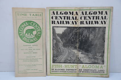
Algoma Central RY March 12, 1944 Public Timetable and BrochureJM Hobby Supply and Railroad Artifact Auctions4.4(127)See Sold PriceFeb 24, 2024
Chicago Burlington and Quincy RR July 5, 1894 Public TimetableJM Hobby Supply and Railroad Artifact Auctions4.4(127)See Sold PriceFeb 24, 2024
The Holy Land Tours - Hamburg American Line - 1911Levy Auction House4.3(11)See Sold PriceFeb 27, 2024
Group of New York Central Railroad Paper - Rule Books, Employee Timetables, Stationary, Log Books,Rail & Road Auctions4.6(165)See Sold PriceMar 07, 2024
Four White Pass & Yukon Route Playing Card DecksRail & Road Auctions4.6(165)See Sold PriceMar 08, 2024
WEST AFRICA Explorers' routes Senegal Ashanti. Mountains of Kong. SDUK 1857 mapJasper524.5(9.9k)See Sold PriceFeb 28, 2024
SECOND WORLD WAR AFRICA. European colonies & German mandates 1940 old mapJasper524.5(9.9k)See Sold PriceFeb 28, 2024
WEST AFRICA explorers' routes. Beaufort Gray Park Dochard Caillie. SDUK 1874 mapJasper524.5(9.9k)See Sold PriceFeb 28, 2024
WEST AFRICA I Explorers' routes Senegal Ashanti Ivory Gold Coast. SDUK 1851 mapJasper524.5(9.9k)See Sold PriceFeb 28, 2024
Central Africa. Map showing great forest traversed by Mr Stanley, 1890Jasper524.5(9.9k)See Sold PriceFeb 28, 2024
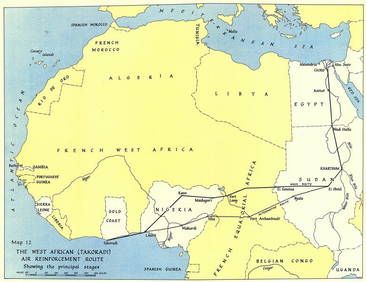
West Africa WW2 Nigeria Sudan Egypt. Takoradi air reinforcement route 1954 mapJasper524.5(9.9k)See Sold PriceFeb 28, 2024
WEST AFRICA showing early explorers' routes & Mountains of Kong. SDUK 1844 mapJasper524.5(9.9k)See Sold PriceFeb 28, 2024