ATLAS of ANTIENT GEOGRAPHY by SAMUEL BUTLER 1843John McInnis Auctioneers,LLC4.6(502)See Sold PriceFeb 24, 2024
18TH C. ANTIQUE MAP: FRENCH & INDIAN WAR, FRAMEDThomaston Place Auction Galleries4.4(386)See Sold PriceFeb 24, 2024
Rand McNally Railroad Map Cabinet w/ 21 Railroad MapsRail & Road Auctions4.6(165)See Sold PriceMar 08, 2024
Keith Haring - Ink on New York Map, Best Buddies, Inscribed, Signed, and DatedSapphire Auction Gallery4(67)See Sold PriceMar 02, 2024
LATE 17TH C. FRENCH MAP OF THE NEW WORLD BY ALEXIS-HUBERT JAILLOT (1632-1712)Thomaston Place Auction Galleries4.4(386)See Sold PriceFeb 24, 2024
Central Railroad of New Jersey Map of Sandy Hook Route-ca. 1903JM Hobby Supply and Railroad Artifact Auctions4.4(126)See Sold PriceFeb 24, 2024
Lot of Six Mixed Atlas Box Cars-HO Scale-New in BoxJM Hobby Supply and Railroad Artifact Auctions4.4(126)See Sold PriceFeb 25, 2024
Rand McNally/Santa Fe Railroad Map of Iowa-1912JM Hobby Supply and Railroad Artifact Auctions4.4(126)See Sold PriceFeb 24, 2024
NICOLAES VISSCHER (NETHERLANDS, 1618-1709) MAP OF THE NEW WORLDThomaston Place Auction Galleries4.4(386)See Sold PriceFeb 24, 2024
17TH C. WORLD MAP BY NICOLAES VISSCHER (NETHERLANDS, 1618-1709)Thomaston Place Auction Galleries4.4(386)See Sold PriceFeb 24, 2024
Lot of Six Mixed Atlas Cabooses-HO Scale-New in BoxJM Hobby Supply and Railroad Artifact Auctions4.4(126)See Sold PriceFeb 25, 2024
Map: Ruscelli Girolamo. Tabula Europae IIII(Italian, 1518-1566) hand-colored map showing Northern Germany and Denmark, 14 1/2 x 10 3/4 in., in painted and gilt wood frameSee Sold Price
SoldMap: Ruscelli Girolamo. Tabula Europae IIII(Italian, 1518-1566). Hand-colored map showing Northern Germany and Denmark, 14 1/2 x 10 3/4 in., in painted and giltwood frameSee Sold Price
SoldBritish Isles.- Ruscelli (Girolamo) Tabula Europae I,British Isles.- Ruscelli (Girolamo) Tabula Europae I, map of the British Isles on a trapezoidal projection, based on Claudius Ptolemy, engraving on laid paper with partial watermark, sheet 210 x 280 mSee Sold Price
SoldEurope.- Ruscelli (Girolamo) - Tabula Europae 1,engraved map showing Ireland, Britain and part of Northern Europe, hand coloured, 195 x 250mm, V enice, c.1561.See Sold Price
SoldPtolomaeus and Ruscelli]Tabula Europæ llPtolomaeus (Claudius) and [Girolamo Ruscelli] Tabula Europæ ll,Spain and Portugal, with the north coast of Africa, ship and sea monsters, woodcut map, 180 x 250mm., central vertical fold, LatiSee Sold Price
Sold[Ptolomaeus and Ruscelli Tabula Europæ lPtolomaeus (Claudius) and [Girolamo Ruscelli] Tabula Europæ l,British Isles and Ireland, with the north coast of Belgium and Germany, ship and sea monsters, woodcut map, 180 x 250mm., centralSee Sold Price
SoldPtolomaeus and Ruscelli Tabua Europæ lllPtolomaeus (Claudius) and [Girolamo Ruscelli] Tabula Europæ lll,France, with lower fringes of the British Isles and part of Spain, ship and seamonster, woodcut map, 180 x 245mm., central vertiSee Sold Price
Ptolomaeus and Ruscelli Tabula Europæ llllPtolomaeus (Claudius) and [Girolamo Ruscelli] Tabula Europæ llll,Germany, with vignettes of an antelope, bisons and a bull, woodcut map, 180 x 250mm., central vertical fold, Latin text on versSee Sold Price
Ptolemaic map of Italy 1561Heading: (Italy & Balkans) Author: Ruscelli, Girolamo - Ptolemy, Claudius Title: Europae Tabula V Place Published: Venice Publisher: Date Published: c.1561 Description: CoppSee Sold Price
Ptolomaeus (C) & G Ruscelli Europæ Tabula 1XPtolomaeus (Claudius) & Girolamo Ruscelli. Europæ Tabula 1X,eastern Europe, part Greece and Turkey, woodcut map, 180 x 245mm., Latin text on verso, central vertical fold, some ink rubbing, texSee Sold Price
SoldPtolomaeus & Ruscelli Europæ Tabula VPtolomaeus (Claudius) and [Girolamo Ruscelli] Europæ Tabula V; Tavola Nuova di Schiavonia,Dalmatian coast and part of Italy, 2 woodcut maps, 180 x 245mm., central vertical folds, Latin text onSee Sold Price
SoldMiddle East & Eastern Europe.- Ruscelli (Girolamo) FiveMiddle East & Eastern Europe.- Ruscelli (Girolamo) Five maps from: La Geografia di Claudio Tolomeo Alessandrino, including Tabula Asiae I, VII, and X, Europae Tabula IX, and Natolia Nuova Tavola, engrSee Sold Price
Map of the Near East. Girolamo Ruscelli. Venice, 1562.Tabula Asiae IIII. Map of the Near East according to Ptolemy. By Giorlamo Ruscelli. From: Ptolemaeus Claudius, Geographia. Venice, 1562. P. 46-47. Page spread from the Holy Land in the west through BaSee Sold Price
SoldTabula Europae I.[British Isles]Giordano Ziletti / Claudius Ptolemy, Tabula Europae I.[British Isles], engraving, from 1574 revised edition by Girolamo Ruscelli of Ptolemy's Geografia., 10.5 x 7.5 10.5 x 7.5See Sold Price
SoldAfter Ptolemy. Europae Tabulae VIII. 1561.[Europe] Ruscelli, Girolamo. “Europae Tabulae VIII.” Venice, Vincente Valgrisio, 1561. Engraved map. 7 5/8” x 10 3/8”. Frame: 21 1/2” x 25”. Text in Italian. DepictSee Sold Price
SoldRuscelli: Antique Map of Greece, 1561Map: Tabula Europae X (authentic Antique Map of Greece) Cartographer: Girolamo Ruscelli Illustrator: Girolamo Ruscell Edition: First Edition Date: 1561 Size: 7.25 x 9.75 inches Authentic sixteenth cenSee Sold Price
SoldRuscelli (Girolamo) Tabula Europae IRuscelli (Girolamo) Tabula Europae I,England and Wales, Scotland orientated with North to the right, Ireland, part of Belgium and Germany, engraving, 190 x 260mm., central vertical fold, someSee Sold Price
SoldMap: Ruscelli Girolamo. Tabula Asiae VI(Italian, 1518-1566) hand-colored map of the Arabian Peninsula, circa 1564, 14 1/2 x 11 in., in gilt and painted wood frameSee Sold Price
SoldRuscelli (Girolamo) Tabula Europae IRuscelli (Girolamo) Tabula Europae I,showing England and Wales, Scotland oriented to the right, Ireland and part of Belgium and Germany, engraving, 190 x 260 mm., Italian text verso, central vSee Sold Price
[MAP]. RUSCELLI. Nueva Hispania tabula nova. [1561].362. [MAP]. RUSCELLI, Girolamo. Nueva Hispania tabula nova. [Venice, 1561]. Copper-engraved map on laid paper, seas stipple engraved, with title at top, Latin text on verso. Neat line to neat line: 18See Sold Price
[MAP]. RUSCELLI. Nueva Hispania.... [Venice, 1598]364. [MAP]. RUSCELLI, Girolamo. Nueva Hispania tabula nova. [Venice, 1598; date based on Burden]. Copper-engraved map on laid paper, seas stipple engraved, with title at top, running head “DescrSee Sold Price
[MAP]. RUSCELLI. Nueva Hispania.... [ca. 1561-1573]363. [MAP]. RUSCELLI, Girolamo. Nueva Hispania tabula nova. [Venice, ca. 1561-1573]. Copper-engraved map on laid paper, seas stipple engraved, with title at top, Italian text with historiated initialSee Sold Price
Ruscelli (Girolamo) Tabula Asiæ I + 2 similarRuscelli (Girolamo) Tabula Asiæ I,ptolomaeic map of Asia Minor, with Turkey in Asia, Crete and Cyprus, engraved map, 195 x 260mm., central vertical fold, Italian text verso, slight surface dirSee Sold Price
Asia.- Silk Road.- Ruscelli (Girolamo) Tabula Asie II,Asia.- Silk Road.- Ruscelli (Girolamo) Tabula Asie II, Ptolemaic map presented on a trapezoidal projection, showing the Caucasus region from modern-day Crimea and Sea of Azov to the mouth of the VolgaSee Sold Price
17TH C. WORLD MAP BY NICOLAES VISSCHER (NETHERLANDS, 1618-1709)Thomaston Place Auction Galleries4.4(386)See Sold PriceFeb 24, 2024
NICOLAES VISSCHER (NETHERLANDS, 1618-1709) MAP OF THE NEW WORLDThomaston Place Auction Galleries4.4(386)See Sold PriceFeb 24, 2024
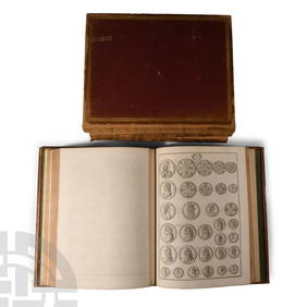
Numismatic Books - Rudding's Coinage of Britain Vol I-III, Plus SuplementTimeLine Auctions Ltd.4.5(183)See Sold PriceMar 09, 2024
Nova Totius Full Color Geographical World MapThe Benefit Shop Foundation Inc.4.3(2.9k)See Sold PriceFeb 28, 2024
Willem Blaeu, Etc. 17th C. Antiquarian Maps, 2Auctions at Showplace4.5(726)See Sold PriceMar 17, 2024
1736 LARGE MAP OF SILESIA POLAND OPPAVIENSIS antique 25 by 34 3/4"Jasper524.5(9.8k)See Sold PriceFeb 27, 2024
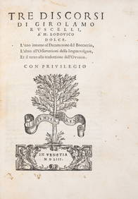
Ruscelli (Girolamo) Tre Discorsi... à m. Ludovico Dolce, first edition, Venice, Plinio Pietrasanta,Forum Auctions4.3(52)See Sold PriceFeb 29, 2024
ANTIQUE 1686 OPERA OMNIA BY JOHN LIGHTFOOT TELLIMA BOUND FOLIO WITH ISRAEL MAPNY Elizabeth 4.3(84)See Sold PriceMar 03, 2024


![Ptolomaeus and Ruscelli]Tabula Europæ ll (1 of 1)](https://p1.liveauctioneers.com/410/10165/2289180_1_x.jpg?height=282&quality=70)


![Tabula Europae I.[British Isles] (1 of 1)](https://p1.liveauctioneers.com/457/2714/1174220_1_x.jpg?height=282&quality=70)


![[MAP]. RUSCELLI. Nueva Hispania tabula nova. [1561]. (1 of 7)](https://p1.liveauctioneers.com/514/38482/16500424_1_x.jpg?height=282&quality=70&version=1363615005)
![[MAP]. RUSCELLI. Nueva Hispania.... [Venice, 1598] (1 of 9)](https://p1.liveauctioneers.com/514/38482/16500428_1_x.jpg?height=282&quality=70&version=1363615005)
![[MAP]. RUSCELLI. Nueva Hispania.... [ca. 1561-1573] (1 of 4)](https://p1.liveauctioneers.com/514/38482/16500426_1_x.jpg?height=282&quality=70&version=1364497535)