ATLAS of ANTIENT GEOGRAPHY by SAMUEL BUTLER 1843John McInnis Auctioneers,LLC4.5(505)See Sold PriceFeb 24, 2024
18TH C. ANTIQUE MAP: FRENCH & INDIAN WAR, FRAMEDThomaston Place Auction Galleries4.4(393)See Sold PriceFeb 24, 2024
Rand McNally Railroad Map Cabinet w/ 21 Railroad MapsRail & Road Auctions4.6(165)See Sold PriceMar 08, 2024
Keith Haring - Ink on New York Map, Best Buddies, Inscribed, Signed, and DatedSapphire Auction Gallery4.1(67)See Sold PriceMar 02, 2024
LATE 17TH C. FRENCH MAP OF THE NEW WORLD BY ALEXIS-HUBERT JAILLOT (1632-1712)Thomaston Place Auction Galleries4.4(393)See Sold PriceFeb 24, 2024
Central Railroad of New Jersey Map of Sandy Hook Route-ca. 1903JM Hobby Supply and Railroad Artifact Auctions4.4(127)See Sold PriceFeb 24, 2024
Lot of Six Mixed Atlas Box Cars-HO Scale-New in BoxJM Hobby Supply and Railroad Artifact Auctions4.4(127)See Sold PriceFeb 25, 2024
Rand McNally/Santa Fe Railroad Map of Iowa-1912JM Hobby Supply and Railroad Artifact Auctions4.4(127)See Sold PriceFeb 24, 2024
NICOLAES VISSCHER (NETHERLANDS, 1618-1709) MAP OF THE NEW WORLDThomaston Place Auction Galleries4.4(393)See Sold PriceFeb 24, 2024
17TH C. WORLD MAP BY NICOLAES VISSCHER (NETHERLANDS, 1618-1709)Thomaston Place Auction Galleries4.4(393)See Sold PriceFeb 24, 2024
Lot of Six Mixed Atlas Cabooses-HO Scale-New in BoxJM Hobby Supply and Railroad Artifact Auctions4.4(127)See Sold PriceFeb 25, 2024
SoldMap reference books.- Burden (Philip D. ) The MappingNO RESERVE Map reference books.- Burden (Philip D. ) The Mapping of North America: A list of printed maps 1511-1670 & 1671-1700, 2 vol., vol.1 signed presentation copy from the author, cracked upper hSee Sold Price
BOOK, References, North America, BurdenReferences, North America. Philip D. Burden, The Mapping of North America - A List of Printed Maps 1511-1670, 1996 (published). Printed Color. An indispensable cartographic reference work for North AmSee Sold Price
SoldBurden, Mapping of North America reference bookTitle: The Mapping of North America: A list of printed maps, 1511-1670 Author: Burden, Philip D. Description: [6], xxiv, 568 pp. Illustrated throughout with reproductions of maps. 14x10¼, gilt-letterSee Sold Price
Sold[Reference]. Burden, Philip D. The Mapping Of Nort[Reference]. Burden, Philip D. The Mapping Of North America: A List of Printed Maps 1511-1670. Rickmansworth: Raleigh Publications, 1996. Folio. 568pp. Cloth. Fine in dj. 11 color plates, over 400 illSee Sold Price
Sold[Reference]. Burden, Philip D. The Mapping Of Nor[Reference]. Burden, Philip D. The Mapping Of North America: A List Of Printed Maps, 1511-1670. [Lon: Raleigh Publications, 1996]. Sm Folio. Cloth in dj. Fine. Profusely illustrated in b&w and color.See Sold Price
Sold2 vols. Cartographic Reference - North America: B2 vols. Cartographic Reference - North America: Burden, Philip D. The Mapping of North America: A List of Printed Maps, 1511-1670. (Rickmansworth, Herts, England), (1996). Folio, orig. cloth, d/j. MapSee Sold Price
Four volumes on North American mapsTitle: Four volumes on North American maps Author: ** Description: Includes: Burden, Philip D. The Mapping of North America. A List of Printed Maps 1511-1670. [Raleigh Publications, 1996]. * Goss, JohSee Sold Price
Sold3 Map Reference Books incl: DEGREES OF LATITUDE.[Map Reference] 3 Titles. ++ Margaret Beck Pritchard and Henry G. Taliaferro. DEGREES OF LATITUDE: MAPPING COLONIAL AMERICA. Colonial Williamsburg Foundation/ Harry N. Abrams, (2002). ++ Seymour I. ScSee Sold Price
Sold18 Map reference books: lot #1: Primarily SoutheasternBook 1: Southeast in Early Maps. 1973 (no dust jacket). Author: Cumming. Book 2: Degrees of Latitude. Author: Pritchard. Book 3: Virginia in Maps. Author: Stephenson. Book 4: Mapping of the American SSee Sold Price
SoldGoss / Tooley. 2 map reference books[Reference]. 2 Titles. Near fine in vg djs. ++ R.V. Tooley. The Mapping Of America. Index compiled by Douglas Matthews. (Lon): Holland Press, (1985). 4to. Covers dozens of 16th-19th century maps thatSee Sold Price
8 map reference books incl Schwartz and Ehrenberg.[Reference] 8 Titles. 4to/folio. Hardcover (7 in dj). Good to near fine. ++ Seymour I. Schwartz and Ralph E. Ehrenberg. THE MAPPING OF AMERICA. Wellfleet Press, (2001). ++ Stefan Lorant (ed.). THE NEWSee Sold Price
SoldMAP REFERENCE BOOK LOT, 6MAP REFERENCE BOOK LOT, 6:Lot includes: R.V. Tooley, "French Mapping of the Americas 1700-1830", 1967, Map Collectors Circle; R.V. Tooley, "A Dictionary of Mapmakers", Parts I-VI, 1965, Map CollectorsSee Sold Price
Sold22 Map reference book: lot #2: Primarily United States.Book 1: Maps of Connecticut. Author: Thompson. Book 2: A la Carte. Author: Library of Congress. Book 3: Mapping of America. Author: Schwartz. Book 4: New England in early Printed Maps 1513 to 1800. AuSee Sold Price
Sold3 books: Early mapping of east Asia.[Map Reference]. 3 Titles. ++ Japan: A Cartographic Vision: European Printed Maps from the Early 16th to the 19th Century. Edited by Lutz Walter. German East-Asiatic Society (OAG). Munich/NY: Prestel,See Sold Price
Sold1 vol. Burden, Philip D. The Mapping of North Ame1 vol. Burden, Philip D. The Mapping of North America. (Rickmansworth, England), (1996). Folio, orig. gilt-lettered burgundy cloth, d/j. Maps. Fine.See Sold Price
SoldBURDEN, PHILIP D. The Mapping of North AmericaBURDEN, PHILIP D. The Mapping of North America: A List of Printed Maps 1511-1670. Profusion of reproductions. Small folio, cloth; dust jacket. (England, 1966) All items are offered for sale subject tSee Sold Price
SoldBurden. THE MAPPING OF NORTH AMERICA. 2 Vols.[Reference] 2 Titles: ++ Philip D. Burden. THE MAPPING OF NORTH AMERICA. ++ THE MAPPING OF NORTH AMERICA II. (Raleigh Publications/Format Ltd, ©1996, ©2007). Cloth, in dj. Minor creasing to top of VSee Sold Price
Sold9 Books + 45 Magazines: Map Reference.[Map Reference] 10 Titles (9 Books + 45 Magazines). ++ R. V. Tooley. THE MAPPING OFAMERICA. Holland Press, (1988). ++ Karrow (general editor). CHECKLIST OF PRINTED MAPS OF THE MIDDLE WEST TO 1900. VolSee Sold Price
SoldBurden's Mapping of North AmericaTitle: The Mapping of North America: A List of Printed Maps, 1511-1670 Author: Burden, Philip D. Description: [6], xxiv, 568 pp. Illustrated throughout with reproductions of maps. 14x10¼, gilt-letterSee Sold Price
Burden's Mapping of North AmericaTitle: The Mapping of North America: A List of Printed Maps, 1511-1670 Author: Burden, Philip D. Description: [6], xxiv, 568 pp. Illustrated throughout with reproductions of maps. 14x10¼, gilt-letterSee Sold Price
SoldThe Mapping of North America, Signed CopyHeading: Author: Burden, Philip D. Title: The Mapping of North America: A List of Printed Maps, 1511-1670 - Signed Place Published: [Rickmansworth, Herts, England] Publisher:[Raleigh Publications]See Sold Price
SoldCollection of Reference BooksCollection of reference books on maps and related subjects, titles include: "Cartography of North America", "Collecting Antique Maps", "Mapping the Silk Road and Beyond", etc., (16) total.See Sold Price
Sold2 Books: Shirley, ...WORLD + Ptolemy, COSMOGRAPHIA[Map Reference/Atlas Facsimile] 2 Titles. ++ Rodney W Shirley. THE MAPPING OF THE WORLD: Early Printed World Maps 1472-1700. Lon: Holland Press, (cprt 1983), (acknowledgements page at end of volume ��See Sold Price
[MAP REFERENCE]. WHEAT. ....Transmississippi West405. [MAP REFERENCE]. WHEAT, Carl I[rving]. Mapping the Transmississippi West.... San Francisco: Grabhorn Press for the Institute of Historical Cartography, 1957-1963. Copious maps illustrated, some fSee Sold Price
Crams Colored Railway Map and Shippers Guide of South Dakota 1908-1909JM Hobby Supply and Railroad Artifact Auctions4.4(127)See Sold PriceFeb 24, 2024
JOHN FULTON Coke Coal Mining Rare c1895 1st Edition TreatiseLuis Porretta Fine Arts4.3(10)See Sold PriceMar 02, 2024
1885 CIVIL WAR 1ed Famous Memoirs US Grant Sheridan Sherman 6v RARE LOT MapsSchilb Antiquarian Rare Books4.8(428)See Sold PriceMar 10, 2024
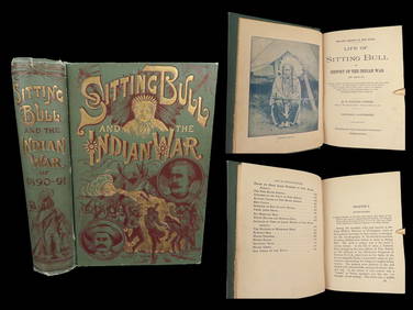
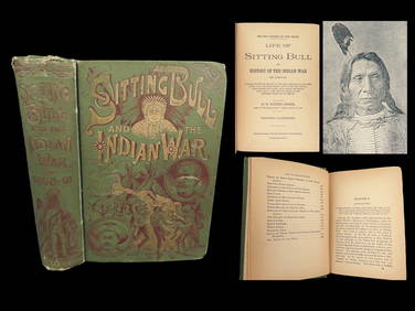
1891 Sitting Bull 1st ed Life Native American Sioux Indians DAKOTA Ghost DanceSchilb Antiquarian Rare Books4.8(428)See Sold PriceMar 10, 2024
EARLY 18TH C. DUTCH CHART OF PACIFIC OCEAN BY FREDERIK DE WIT (1629-1706) WITH CALIFORNIA AS ANThomaston Place Auction Galleries4.4(393)See Sold PriceFeb 24, 2024
PHILIP NORMAN FSA Hand Colored Engraving c1910 Loch White Fairies SIGNED Listed ScotlandLuis Porretta Fine Arts4.3(10)See Sold PriceMar 02, 2024
Map UNITED COUNTIES LEEDS & GRENVILLE by Walling 1861 Rare Canada Map 5ft x 5ftLuis Porretta Fine Arts4.3(10)See Sold PriceMar 02, 2024
MAP - PIETER SCHENK / VALK / JANSSEN Hand Colored superb Map Central Italy c1702Luis Porretta Fine Arts4.3(10)See Sold PriceMar 02, 2024
AMBROISE TARDIEU c1822 Napoleonic War Map GermanyLuis Porretta Fine Arts4.3(10)See Sold PriceMar 02, 2024
PIETER SCHENK / VALK / JANSSEN Hand Colored Map of Rhodes Greece ca1702 vgcLuis Porretta Fine Arts4.3(10)See Sold PriceMar 02, 2024
1872 Holy BIBLE & Hitchcock Analysis Gruden Concordance Theology MAPS Holy LandSchilb Antiquarian Rare Books4.8(428)See Sold PriceMar 31, 2024
1891 DAKOTA Indians 1st ed Life Sitting Bull Native American Sioux Ghost DanceSchilb Antiquarian Rare Books4.8(428)See Sold PriceMar 31, 2024
These United States 1968 Folio Size HardbackNorth American Artifact Auctions4.7(198)See Sold PriceApr 20, 2024
HAMMOND'S READY REFERENCE HISTORICAL ATLAS 1920North American Artifact Auctions4.7(198)See Sold PriceApr 20, 2024
Arrowsmith & Lewis - Map of PolynesiaTrillium Antique Prints & Rare Books4.5(32)See Sold PriceFeb 24, 2024
Arrowsmith & Lewis - Map of North AmericaTrillium Antique Prints & Rare Books4.5(32)See Sold PriceFeb 24, 2024
Arrowsmith & Lewis - Map of the World on Mercator's ProjectionTrillium Antique Prints & Rare Books4.5(32)See Sold PriceFeb 24, 2024
Arrowsmith & Lewis - Map of LouisianaTrillium Antique Prints & Rare Books4.5(32)See Sold PriceFeb 24, 2024
Arrowsmith & Lewis - Map of the United StatesTrillium Antique Prints & Rare Books4.5(32)See Sold PriceFeb 24, 2024
De Jode, Rare, pub. 1593 - Map of Africa (Africae Vera Forma, et Situs)Trillium Antique Prints & Rare Books4.5(32)See Sold PriceFeb 24, 2024
1738 RUSSIA SIBERIA & GREAT TARTARY Description illustrated ANTIQUE in ENGLISHJasper524.5(9.9k)See Sold PriceFeb 27, 2024


![[Reference]. Burden, Philip D. The Mapping Of Nort (1 of 1)](https://p1.liveauctioneers.com/179/1435/617526_1_x.jpg?height=282&quality=70)
![[Reference]. Burden, Philip D. The Mapping Of Nor (1 of 0)](https://p1.liveauctioneers.com/dist/images/placeholder.jpg?height=282&quality=70)


![[MAP REFERENCE]. WHEAT. ....Transmississippi West (1 of 7)](https://p1.liveauctioneers.com/514/38482/16500510_1_x.jpg?height=282&quality=70&version=1363615005)