Aviation Broadsides: JOHNNY UPSIDE DOWN MILLER Stunt Flying Exhibition Posters, c.1930Kensington Estate Auction4.6(219)See Sold PriceFeb 26, 2024
1900s BUFFALO, N.Y. & NIAGRA FALLS American Stamped Postcards (100+)Kensington Estate Auction4.6(219)See Sold PriceFeb 26, 2024
SoldMap of TX, OR & CA Print (87443)Print of 1846 map of TX, OR and CA by Mitchell. 22x27". 1" tear, stains on border only. Date: State/Country: City/County:See Sold Price
SoldMitchell. New Map of TX, OR, and CASuperb Copy of a Landmark Map & Guide for the American West 65. [MAP]. MITCHELL, S[amuel] Augustus. A New Map of Texas Oregon and California with the Regions Adjoining. Compiled from the Most Recent ASee Sold Price
Accompaniment Book 1846 to Mitchells Map TX,OR, CA RegionsTexas, Oregon, California Accompaniment book to New Mitchells map issued in 1846. This is rare find. Published in Philadelphia by Augustus Mitchell Dimensions: 5.25 inches x 3.25 inches. Please referSee Sold Price
SoldMitchell New Map of TX, OR, CA 1849After, Mitchell, Samuel Augustus (1790-1860). A new map of Texas, Oregon and California with Regions Adjoining. Lithographed map with original hand color in full. Philadelphia: Thomas Cowperthwait & CSee Sold Price
Mitchell New Map of TX, OR, CA 1846Mitchell, Samuel Augustus (1790-1860). A new map of Texas, Oregon and California with Regions Adjoining. Lithographed map with original hand color in full. Philadelphia: Mitchell, 1846 (First edition)See Sold Price
SoldFour Washington D.C. Related Maps & Prints ca. 19th CenturyGroup of four Washington D.C. related maps & prints, ca. mid to late 19th century. Frame size of "Map of Washington. District of Columbia." are 10 1/2" H x 11 1/2" W x 3/8" D.See Sold Price
Original 1950 Travel Poster Air France Zodiac MapBoucher, Lucien 1889 - 1971Air France (Map)Letterpress Print ca. 195028.7 x 42.9 in. (73 x 109 cm)Printer: Perceval, ParisCondition Details: (B+)needle holes and minor staining in the marginsEstimate:See Sold Price
SoldUnknown Lithograph, Colored, Jack-O-Pa: A Chippewa ChiefJack-O-Pa: A Chippewa Chief. Approx. 19 7/8 x 13 3/4 in. Mounted to masonite board. Light foxing. Provenance: Susan Benjamin Rare Prints & Maps, Santa Paula, CaSee Sold Price
SoldArtist Unknown Lithograph, Colored, O-Hya-Wa-Mince-Kee, A Chippewa Chief, 1843O-Hya-Wa-Mince-Kee, A Chippewa Chief, 1843, signature not applicable. Approx. 19 3/4 x 13 3/4 in. Mounted to masonite board. Foxing.Provenance: Susan Benjamin Rare Prints & Maps, Santa Paula, CaSee Sold Price
SoldALBERT RICHARD FOOTBALL MAP CA 1950:ALBERT RICHARD FOOTBALL MAP CA 1950: USA Map of College Football Conferences and Colleges with Legend of Schools and Nicknames. Back when North Dakota was the "NODAKS". Wood Framed Print on Cardboard.See Sold Price
SoldWeyer's Grand Caverns Cave Map, ca. 1835"A Ground Plan and Section of Weyer's Cave Augusta CO. VA.", ca. 1835. Designed and drawn by Robert L. Cooke, Staunton, VA, lithograph by Childs & Lehman, Lith.rs, Philadelphia. Includes an overhead pSee Sold Price
Paul E. Maxwell (1925 - 2015) CompositionPaul E. Maxwell (TX, CA, 1925 - 2015) Large framed abstract mixed media. Pencil signed lower right. Paul Maxwell is known for Mixed-media abstraction, conceptual, sculpture, prints. Image Size: 29 x 4See Sold Price
VANDERMAELEN. Largest Scale Colonial Maps of TXLargest Scale Colonial Maps of Texas—“difficult to assemble”—Streeter 369. [MAP]. VANDERMAELEN, Ph[See Sold Price
Rare German Pocket Map showing CA Gold FieldsRare German Pocket Map with Inset showing California Gold Fields 268. [MAP]. BEYERLEIN, Sigmund. Neueste Post- u. EisenbSee Sold Price
Uncommon, Large & Handsome 1892 Pocket Map of CAUncommon, Large & Handsome 1892 Pocket Map of California 264. [MAP]. AMERINE, [C.H.] & [F.E.] Willson. Amerine & WiSee Sold Price
Sold20 VINTAGE ADVERTISING FRUIT LABELS Fl, CA, TX20 VINTAGE ADVERTISING LITHOGRAPHED FRUIT LABELS FLORIDA, CALIFORNIA, TEXAS all date between c.1930 - 1950s fruit labels: Table Treat, California (4" x 13"); Silver Cup California Grapes (4" x 13"); ESee Sold Price
Young. Map of TX, 1858Another Elusive Texas Almanac Map-With an Emphasis on Railroads-1858 156. [MAP]. YOUNG, J[ames] H[amilton]. Map of the State of Texas from the Latest Authorities, by J. H. Young. Published by CharlesSee Sold Price
SoldLondon The Bastion of Liberty. Vintage Tourism TravelLondon The Bastion of Liberty. Vintage Tourism Travel Map Poster. London: Pictorial Maps Ltd., ca. 1960s. Highly detailed offset lithograph map with an overview of London, vignettes of notable sites aSee Sold Price
SoldLobby Photo of Blackstone’s Map of Europe Illusion.Blackstone, Harry (Henry Boughton). Lobby Photo of Blackstone's Map of Europe Illusion. New York: Cohita Studio, ca. 1920s. Sepia print depicting the magician and five of his assistants beside a map oSee Sold Price
SoldTX Pictorial Lettersheet, ca. 1855Rare Texas Pictorial Lettersheet with Letter of a French Emigrant Main Plaza, San Antonio, Texas ca. 1855 242. [TEXAS PICTORIAL LETTERSHEET]. THIELEPAPE, Wilhelm Carl August. Main Plaza. San Antonio,See Sold Price
SoldFramed Lithograph Map of Texas - , TXc1900 Map of Texas and the Indian Territory. The state of Oklahoma is still depicted as “Indian Territory†therefore this map was created before 1907. Produced by Frank Gray and printed in PSee Sold Price
COLTON. Map of the TX and Pacific Railway. 1876Map of the Most Important Railroad in Post-Civil War Texas 281. [MAP]. COLTON, G[eorge] W[oolworth] & C[harles] B. MSee Sold Price
Ca. 1800 Map of the World`Ca. 1800 Map of the WorldSigned in plate: B. Baker, IslingtonSize: Approximately 8 5/8" x 14 1/4"Condition: Breaks and gaps along folds. A hole at the east coast of New Holland. Some stainingSee Sold Price
[MAP]. CADENA Y MARIN. Estado de Coahuila de Zaragoza.250. [MAP]. CADENA Y MARIN, Aurelio. Plano Geografico, Mercantil y Politico del Estado de Coahuila de Zaragoza.... [below lower neat line] Lit. C. Montauriol y Ca. M; [map at center] CoahuilaSee Sold Price
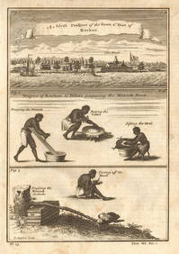
Guinea-Bissau Cacheu town Fortaleza de São José da Amura Preparing cassava 1745Jasper524.5(9.9k)See Sold PriceFeb 28, 2024
Nigeria & Chad. French West & Equatorial Africa. Cameroon. TIMES 1956 old mapJasper524.5(9.9k)See Sold PriceFeb 28, 2024
Africa. French Equatorial Africa. Rhodesia. Belgian Congo. TIMES 1956 old mapJasper524.5(9.9k)See Sold PriceFeb 28, 2024
Morocco Algeria. French & Spanish West Africa. Sahara sand dunes. TIMES 1956 mapJasper524.5(9.9k)See Sold PriceFeb 28, 2024
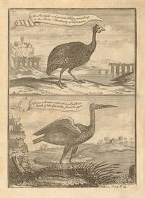
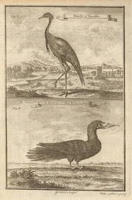
Pintado or Guinea-Hen. African Swan, or Gambian Stork. West African birds 1745Jasper524.5(9.9k)See Sold PriceFeb 28, 2024
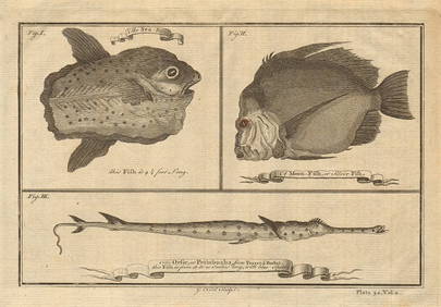
Ocean sunfish. Opah Moonfish. Orsie Petinbuaba Filefish. West African Fish 1745Jasper524.5(9.9k)See Sold PriceFeb 28, 2024
AFRICA. European Possessions in Central; map of Zanzibar 1907 old antiqueJasper524.5(9.9k)See Sold PriceFeb 28, 2024
West African fruit. Kola nut. Guava fruit. Kalabash Calabash tree 1745 printJasper524.5(9.9k)See Sold PriceFeb 28, 2024
Gambian birds. Monoceros. A bird with four wings. CHILD 1745 old antique printJasper524.5(9.9k)See Sold PriceFeb 28, 2024
Bougainville's 1766 circumnavigation. France-Africa-Réunion. GENTS MAG 1774 mapJasper524.5(9.9k)See Sold PriceFeb 28, 2024
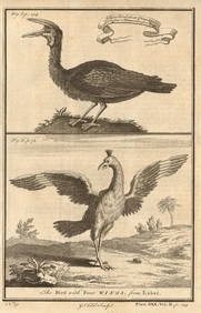
West African Birds. Crane Demoiselle. Alcatrazi or Mad-Bird. Albatross 1745Jasper524.5(9.9k)See Sold PriceFeb 28, 2024
MAGHREB. North Africa. Marocco Algeria and Tunis. BLACKIE 1886 old antique mapJasper524.5(9.9k)See Sold PriceFeb 28, 2024
Central Africa. Map showing great forest traversed by Mr Stanley, 1890Jasper524.5(9.9k)See Sold PriceFeb 28, 2024
French West Africa. Gold Coast. Sahara desert sand dunes. TIMES 1956 mapJasper524.5(9.9k)See Sold PriceFeb 28, 2024
ANCIENT NORTH AFRICA Septentrionalis. Mauretania Tripolitana ARROWSMITH 1828 mapJasper524.5(9.9k)See Sold PriceFeb 28, 2024
AFRICA. French North Africa and Morocco 1907 old antique map plan chartJasper524.5(9.9k)See Sold PriceFeb 28, 2024
EARLY COLONIAL WEST AFRICA. Empires of Sokoto Gando Mas.Tribes.Fellatah 1886 mapJasper524.5(9.9k)See Sold PriceFeb 28, 2024
West Africa gold trinkets worn as spells and utensils. jewels ornaments 1745Jasper524.5(9.9k)See Sold PriceFeb 28, 2024
Vintage Framed Cat Island Nautical Map PrintRapid Estate Liquidators and Auction Gallery4.5(1.1k)See Sold PriceFeb 25, 2024
Framed Tropical West Indies Map PrintRapid Estate Liquidators and Auction Gallery4.5(1.1k)See Sold PriceFeb 26, 2024
Set of 3 Maps - Netherlands - Belgien - Switzerland - J. BarlowProverde Auctions4.3(3)See Sold PriceFeb 28, 2024
20 Pcs Vintage Ephemera incl Political Cigar BansCordier Auctions & Appraisals4.4(1.5k)See Sold PriceMar 02, 2024


![[MAP]. CADENA Y MARIN. Estado de Coahuila de Zaragoza. (1 of 6)](https://p1.liveauctioneers.com/514/38480/16487104_1_x.jpg?height=282&quality=70&version=1363614971)