1968 Gibson LG-0 Acoustic Dreadnought Parlor GuitarHess Fine Auctions4.4(195)See Sold PriceMar 02, 2024
Gibson ES335 Semi Hollow Vintage Sunburst Electric Guitar with Certificate of Authenticity Hand MadeHess Fine Auctions4.4(195)See Sold PriceMar 02, 2024
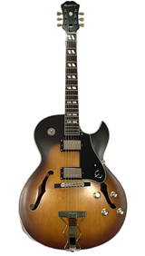
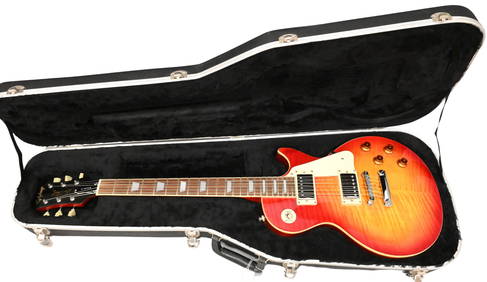
Epiphone ES175 Vintage Sunburst Hollow Body Electric Archtop Guitar with USA Gibson PickupsHess Fine Auctions4.4(195)See Sold PriceMar 02, 2024
Gibson SG Diablo Red and Gold Electric Guitar with Hard Case Hand Made in USA Extremely RareHess Fine Auctions4.4(195)See Sold PriceMar 02, 2024
JAMES GIBSON BACKWOOODS PINES HIGHWAYMEN PAINTINGVero Beach Auction4.7(677)See Sold PriceMar 02, 2024
2011 Epiphone Gibson Les Paul Standard Electric Guitar in Tiger MapleNadeau's Auction Gallery4.7(398)See Sold PriceFeb 24, 2024
1990 USA Gibson Les Paul Studio Electric GuitarNadeau's Auction Gallery4.7(398)See Sold PriceFeb 24, 2024
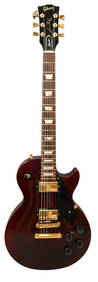
2006 Epiphone Les Paul by Gibson Electric Guitar in Tiger Cherry SunburstNadeau's Auction Gallery4.7(398)See Sold PriceFeb 24, 2024
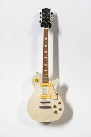
Gibson Les Paul Honey Sunburst Traditional Electric Guitar with Hard Case Hand Made in USA 2008Hess Fine Auctions4.4(195)See Sold PriceMar 02, 2024
Map of The South Part of GermanyBy Gibson; plate 117, page 461, copper engraved map, center crease, showing part of Italy and the Gulf of Venice. Matted and framed under glass, sight size 11" x 16", overall 15" x 20". Condition: notSee Sold Price
SoldGibson & Salmon 1759 Map of the South Part of GermanyCopper Engraved Map Published 1759, London for "The Universal Traveller" by Thomas Salmon. Engraved by Gibson. Paper Size: 18.5 x 13.5 inch (47 x 34cm) Some toning along centre fold, some strengtheninSee Sold Price
SoldPhilip, George 1856 LG Hand Col Map. Germany South PartLarge Folio Lithograph Map Published Published 1856 by George Philip, Liverpool for "Philips' Commercial Atlas of the World" Paper Size: 26 x 21 inch (66 x 53cm) Light horizontal bend in centre. NeatlSee Sold Price
Map of The South Part of GermanyBy Gibson; plate 117, page 461, copper engraved map, center crease, showing part of Italy and the Gulf of Venice. Matted and framed under glass, sight size 11" x 16", overall 15" x 20". Condition: notSee Sold Price
E. Bowen. New & correct map of Southwest of GermanyBowen, Emanuel A new and correct map of South West part of Germany C. 1745 Copperplate engraving; uncoloured Printed area: 34.5 x 42 cm; 13.5 x 16.5 in This map, drawn with the utmost sense of precisiSee Sold Price
SoldDeutschland: A correct map ...- A correct map of the South East part of Germany (das Gebiet von Dresden bis Triest, von Ulm bis Krakau). Kupferstich mit zeitgenöss. kolorierter dekorativer Kartusche und zeitgenöss. Grenzkolorit.See Sold Price
SoldDeutschland new and correct map: A new and correctDeutschland new and correct map - A New and Correct Map of the South West part of Germany ... Kupferstich mit zeitgenöss. kolorierter Waffen-Kartusche, kleiner Windrose und Meilenmesser sowie mit zeiSee Sold Price
SoldAntique Printed Europe Map Group18th-19th century AD. A mixed group comprising: a small map of the 'South East part of Germany', by Gibson (1774); a double-page coloured map of 'Prussia' by J. Rapkin; a hand-coloured map of 'FranceSee Sold Price
Four Maps of Germanyde Pretot’s Chorographie du Cercle de Basse Saxe, 1787, 10 x 15 in. (sight); Bowen’s “A New and Correct Map of the South West Part of Germany”, originally published in 1736, circa 1812, 15-1?2See Sold Price
Deutschland: A correct map of the South East part- A correct map of the South East part of Germany (das Gebiet von Dresden bis Triest, von Ulm bis Krakau). Kupferstich mit zeitgenöss. kolorierter dekorativer Kartusche und zeitgenöss. Grenzkolorit.See Sold Price
SoldEmanuel Bowen (1693-1767) British. "A Correct Map ofEmanuel Bowen (1693-1767) British. "A Correct Map of the South East Part of Germany", Map, 14" x 16.5"See Sold Price
Deutschland/Österreich: verschiedene KartenDeutschland. A correct Map of the North West / of the South West part of Germany. 2 Kupferstiche, jeweils mit dekorativer Kartusche und Windrose. Je ca 35 x 43 cm. By Eman(uel) Bowen. Um 1740. AusgezeSee Sold Price
SoldDeutschland/Österreich: verschiedene Karten- A correct Map of the North West / of the South West part of Germany. 2 Kupferstiche, jeweils mit dekorativer Kartusche und Windrose. Je ca 35 x 43 cm. By Eman(uel) Bowen. Um 1740.Ausgezeichnete DrucSee Sold Price
Germany. Part 2,3, western area and south.Title/Content of Map: Germany. Part 2,3, western area and south. Date: 1863 Cartographer: By Johnson & Ward. From, Johnson’s New Illustrated Family Atlas Size: 18x26 1/2” Provenance: New York HandSee Sold Price
Germany. Part 2,3, western area and south.Title/Content of Map: Germany. Part 2,3, western area and south. Date: 1863 Cartographer: By Johnson & Ward. From, Johnson’s New Illustrated Family Atlas Size: 18x26 1/2” Provenance: New York AddiSee Sold Price
SoldGermany. Part 2,3, western area and south.Title/Content of Map: Germany. Part 2,3, western area and south. Date: 1863 Cartographer: By Johnson & Ward. From, Johnson’s New Illustrated Family Atlas Size: 18x26 1/2” Provenance: New York AddiSee Sold Price
Germany. Part 2,3, western area and south.Title/Content of Map: Germany. Part 2,3, western area and south. Date: 1863 Cartographer: By Johnson & Ward. From, Johnson’s New Illustrated Family Atlas Size: 18x26 1/2” Provenance: New York AddiSee Sold Price
Germany. Part 2,3, western area and south.Title/Content of Map: Germany. Part 2,3, western area and south. Date: 1863 Cartographer: By Johnson & Ward. From, Johnson’s New Illustrated Family Atlas Size: 18x26 1/2” Provenance: New York AddiSee Sold Price
SoldA small group of maps of south west Germany-. A small group of maps of south west Germany, including maps of the environs of Treves, Hessen, Nassau, part of the Rhein, each with decorative title cartouche, by R. & J. Ottens, H. JaillotSee Sold Price
South Part of Turkey in Europe. Greece & Aegean.TITLE/CONTENT OF MAP: 'South Part of Turkey in Europe comprehending Ancient Graecia, and part of Macedonia and Thrace' The top image on the right hand side shows the entire map. To view a close up ofSee Sold Price
South Part of Turkey in Europe. Greece & Aegean.TITLE/CONTENT OF MAP: 'South Part of Turkey in Europe comprehending Ancient Graecia, and part of Macedonia and Thrace' The top image on the right hand side shows the entire map. To view a close up ofSee Sold Price
Physical map of South Germany. Europe. 1871.Print from steel engraving titled „Carte physique de L‘ Allegne du Sud“.Author/compiler - MM. Drioux et Ch. Leroy.Engraved by Jenotte.Notes: 51.From „Atlas universel et classique de geographieSee Sold Price
SoldSidney Hall: Antique Map of South Italy, 1856Title/Content of Map: 'Italy, south part [inset: Malta and its dependencies]' Sardinia Sicily. Date Printed: 1856 Image Size: Approx 28.5 x 41.0cm, 11.25 x 16 inches (Large) Type: Antique atlas map wiSee Sold Price
South-Eastern part of Tierra del Fuego with StatenTitle/Content of Map: South-Eastern part of Tierra del Fuego with Staten Island, Cape Horn and Diego Ramirez Islands Date Printed: 1841-03-16 Cartographer: Robert Fitz Roy, J. & C. Walker Size: 24X37.See Sold Price
AMBROISE TARDIEU c1822 Napoleonic War Map GermanyLuis Porretta Fine Arts4.3(10)See Sold PriceMar 02, 2024
MAP - AMBROISE TARDIEU c1822 Napoleonic Miltary Map GermanyLuis Porretta Fine Arts4.3(10)See Sold PriceMar 02, 2024
Carey, pub. 1796 - Map of the Tennassee State formerly part of North Carolina (Tennessee)Trillium Antique Prints & Rare Books4.5(28)See Sold PriceFeb 24, 2024
1764 Bellin Chart of Three South Haitian Bays -- Carte des Bayes du Mesle des Flamands et deJasper524.5(9.7k)See Sold PriceFeb 27, 2024
SOUTH CENTRAL AFRICA. Shows Zambesi river as circular! WELLER 1863 old mapJasper524.5(9.7k)See Sold PriceFeb 28, 2024
Northern & Southern Africa. Maghreb. Orange River Sovereignty. HALL 1854 mapJasper524.5(9.7k)See Sold PriceFeb 28, 2024
Afrique. Pays des Hottentots #50. Namibia South Africa VANDERMAELEN 1827 mapJasper524.5(9.7k)See Sold PriceFeb 28, 2024
Northern & Southern Africa. Maghreb. Orange River Sovereignty. HALL 1856 mapJasper524.5(9.7k)See Sold PriceFeb 28, 2024
L'Afrique Françoise ou du Senegal'. French West Africa. DE L’ISLE 1727 mapJasper524.5(9.7k)See Sold PriceFeb 28, 2024