ATLAS of ANTIENT GEOGRAPHY by SAMUEL BUTLER 1843John McInnis Auctioneers,LLC4.5(505)See Sold PriceFeb 24, 2024
18TH C. ANTIQUE MAP: FRENCH & INDIAN WAR, FRAMEDThomaston Place Auction Galleries4.4(394)See Sold PriceFeb 24, 2024
Rand McNally Railroad Map Cabinet w/ 21 Railroad MapsRail & Road Auctions4.6(165)See Sold PriceMar 08, 2024
Keith Haring - Ink on New York Map, Best Buddies, Inscribed, Signed, and DatedSapphire Auction Gallery4.1(67)See Sold PriceMar 02, 2024
LATE 17TH C. FRENCH MAP OF THE NEW WORLD BY ALEXIS-HUBERT JAILLOT (1632-1712)Thomaston Place Auction Galleries4.4(394)See Sold PriceFeb 24, 2024
Central Railroad of New Jersey Map of Sandy Hook Route-ca. 1903JM Hobby Supply and Railroad Artifact Auctions4.4(127)See Sold PriceFeb 24, 2024
Lot of Six Mixed Atlas Box Cars-HO Scale-New in BoxJM Hobby Supply and Railroad Artifact Auctions4.4(127)See Sold PriceFeb 25, 2024
Rand McNally/Santa Fe Railroad Map of Iowa-1912JM Hobby Supply and Railroad Artifact Auctions4.4(127)See Sold PriceFeb 24, 2024
NICOLAES VISSCHER (NETHERLANDS, 1618-1709) MAP OF THE NEW WORLDThomaston Place Auction Galleries4.4(394)See Sold PriceFeb 24, 2024
17TH C. WORLD MAP BY NICOLAES VISSCHER (NETHERLANDS, 1618-1709)Thomaston Place Auction Galleries4.4(394)See Sold PriceFeb 24, 2024
Lot of Six Mixed Atlas Cabooses-HO Scale-New in BoxJM Hobby Supply and Railroad Artifact Auctions4.4(127)See Sold PriceFeb 25, 2024
Map of St. Paul / Map of the City Of Fargo, CassTitle: Map of St. Paul / Map of the City Of Fargo, Cass County, North Dakota Publication Date: 1904 © Cartographer: CRAM, GEORGE F. Publisher: GEO. F. CRAM Size: 13.3x10.3 Seldom found city plan ofSee Sold Price
Map of St. Paul, Minneapolis, and Environs.Title/Content of Map: Map of St. Paul, Minneapolis, and Environs. Date: 1889 Cartographer: Rand McNally & Co. Size: 19X26 Large extremely detailed showing city limits, parks, railroads, lakes, etc. InSee Sold Price
SoldLondon and its environs.- Speed (John) Midle-SexLondon and its environs.- Speed (John) Midle-Sex described with the most famous Cities of London and Westminster, with inset plans and views of St Paul's and Westminster Abbey, engraved map with hand-See Sold Price
SoldSPEED'S MAP OF 'MIDLE-SEX', LONDON, CIRCA 17TH C.The historic county of Middle-Sex depicted with the cities of London and Westminster, additional inset map of Westminster upper left and London upper right, views of 'St. Peters' and 'St. Paul's CatheSee Sold Price
SoldANTIQUE 17th/18th c MAP ST PAULAntique 17th/18th c. Map showing the travels of The Apostles and St. Paul in the Mediterranean. Professionally framed and matted, measures 23"x26"x1". Weight 7 pds. PROVENANCE: A Private Charleston SCSee Sold Price
Sold1853-4 Map St. Paul To Rivere Des Lacs - Map No 11853-4 Map St. Paul To Rivere Des Lacs - Map No 1. Map is under shrink wrap and on cardboard, some tears on one side. Measures approx. 24''H x 36''W. Some text on this map reads: ''Explorations and suSee Sold Price
SoldMap of St. Paul, Minneapolis, Rand, McNally & Co. 1898Map: St. Paul, Minneapolis and Environs Publisher: Rand, McNally & Co. 1898 New Standard Atlas of the World Size: 21.5 x 28 inches No Reserve: This lot starts at $1 and has no reserve as a courtesy soSee Sold Price
St. Paul 1896Title/Content of Map: St. Paul 1896 Date Printed: 1896 Material/Medium: Paper Size: approx 11x14 inches Rand McNally & Co. Universal Atlas of the World Reserve: $30.00 Shipping: Domestic: Flat-rate oSee Sold Price
Calmet: Antique Map Malta / St. Paul’s Shipwreck, 1728Map: Ancien Plan de l'Isle de Malte, ou S. Paul Aborda apres son Naufrage, Act XXVIII Cartographer: Calmet Place & Date: Paris / 1728 Size: 17" x 12" Condition: b&w; light overall age toning The verySee Sold Price
SoldFramed Print Of Map Of St. PaulFramed print of the Rand McNally commercial atlas map of St. Paul from 1915. Image might need readjustment in frame. Frame is board with cream metallic sheen. Approximately 15 inches in height by 21inSee Sold Price
1902 Chicago Milwaukee and St. Paul Railway Map ThThis is an original Chicago Milwaukee and St. Paul Railway Map showing the Western and Mid Western United States. The map has been shrink wrapped onto foam board and shows a 22" rip as seen in the phoSee Sold Price
SoldColton's St. Louis/Chicago Map [Midwest City Map]Colton's Pittsburgh and Cincinnati Map; top is Pittsburgh and bottom is Cincinnati. J. H. Colton Cartographer. Published by J. H. Colton, New York. Stamped 'Entered according to Act of Congress in theSee Sold Price
SoldColton's St. Louis/Chicago Map [Midwest City Map]Colton's St. Louis and Chicago Map; left is St. Louis and right is Chicago. J. H. Colton Cartographer. Published by J. H. Colton, New York. Stamped 'Entered according to Act of Congress in the Year 18See Sold Price
Rand-McNally New Commercial Atlas Map of St. PaulTitle: Rand-McNally New Commercial Atlas Map of St. Paul Minneapolis And Environs. Publication Date: 1914 Cartographer: RAND-MCNALLY & COMPANY Publisher: RAND-MCNALLY & CO. Size: 26x19 Page 192-193 frSee Sold Price
GENUINE 1951 MAP OF ST. PAUL MNGENUINE 1951 MAP OF ST. PAUL MN **|**|** GENUINE 1951 MAP OF ST. PAUL MN #70588v2See Sold Price
SoldSt. Paul and Palestine Maps1.) 1867 Palestine map published by A. J. Johnson. 15" high x 10-1/2" wide. 2.) Johnson's map of St. Paul's Journeyings between Rome and Jerusalem. Published by A. J. Johnson. 1868. 6-3/4" high x 10-1See Sold Price
Sold1855 Colton Map of Chicago and St. Louis -- The CityTitle/Content of Map: 1855 Colton Map of Chicago and St. Louis -- The City Map of St. Louis Missouri [with] The City Map of Chicago Illinois Date: 1855, New York Cartographer: J ColtonSize: 11.8 X 14.See Sold Price
SoldMeyer (C.) and H. van Minden. - Map of Minnesotalocally published state map with inset plan of St Paul, engraved map with extensive original hand-colouring, 770 x 560mm., occasional minor splits on old folds, minor creasing at sheet edges, foldingSee Sold Price
Biblical themed two in one map. Top: St. Paul’s travels, lower: Egypt, travels of theTitle: Biblical themed two in one map. Top: St. Paul’s travels, lower: Egypt, travels of the Israelites. 1846. By A and C Black Date/Period: 1846 Materials: Copperplate engraved Size: 12 x 17" BSee Sold Price
1855 Colton Map of Chicago and St. Louis -- The CityReserve Reduced! Title/Content of Map: 1855 Colton Map of Chicago and St. Louis -- The City Map of St. Louis Missouri [with] The City Map of Chicago Illinois Date: 1855, New York Cartographer: J ColtoSee Sold Price
Survey of Route Near the 47th and 49th ParallelsTitle: Two survey maps of the Route Near the 47th and 49th Parallels Author: Stevens, Isaac I. Description: Includes: Map No.1. St. Paul to Riviere des Lacs. 62x93 cm. * Route near the 47th and 49th PSee Sold Price
Survey of Route Near the 47th and 49th ParallelsTitle: Two survey maps of the Route Near the 47th and 49th Parallels Author: Stevens, Isaac I. Description: Includes: Map No.1. St. Paul to Riviere des Lacs. 62x93 cm. * Route near the 47th and 49th PSee Sold Price
Survey of Route Near the 47th and 49th ParallelsTitle: Two survey maps of the Route Near the 47th and 49th Parallels Author: Stevens, Isaac I. Description: Includes: Map No.1. St. Paul to Riviere des Lacs. 62x93 cm. * Route near the 47th and 49th PSee Sold Price
SoldNew York City ANTIQUE MAP 40th ST TO HARLEM 1842Details: This original antique pocket map printed in 1842 unfolds to display a section of New York City from 40th St. to Harlem.When opened, this map measures approximately 18â€x14â€.Please attSee Sold Price
Lake Superior and Mississippi River RR 1869 Seven Percent Bonds Book/Report-1869JM Hobby Supply and Railroad Artifact Auctions4.4(127)See Sold PriceFeb 24, 2024
Chicago Milwaukee and St Paul RY Panama Pacific Exposition Brochure-1915JM Hobby Supply and Railroad Artifact Auctions4.4(127)See Sold PriceFeb 24, 2024
Chicago Milwaukee and St Paul RY To the Lakes of Wisconsin and Minnesota Book-1909JM Hobby Supply and Railroad Artifact Auctions4.4(127)See Sold PriceFeb 24, 2024
Chicago Milwaukee and St Paul RY Why and Wherefore Book-1886JM Hobby Supply and Railroad Artifact Auctions4.4(127)See Sold PriceFeb 24, 2024
Chicago St Paul and Kansas City RY Color Advertising PieceJM Hobby Supply and Railroad Artifact Auctions4.4(127)See Sold PriceFeb 24, 2024
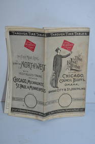
Chicago Milwaukee and St Paul RY March 1, 1889 Public TimetableJM Hobby Supply and Railroad Artifact Auctions4.4(127)See Sold PriceFeb 24, 2024
Illinois Central RR July 24, 1906 Western Lines Public TimetableJM Hobby Supply and Railroad Artifact Auctions4.4(127)See Sold PriceFeb 24, 2024
17TH C. MAP OF THE BERKSHIRES BY JOHN SPEED, FRAMEDThomaston Place Auction Galleries4.4(394)See Sold PriceFeb 24, 2024
FRANK MARMINGTON c1910 National Gallery Canada Signed Engraving London St. Pauls 20" x 16"Luis Porretta Fine Arts4.3(10)See Sold PriceMar 02, 2024
Vatican City Token - John Paul II St Peter's Basilica Silver coinBazaar of Persia4.4(26)See Sold PriceFeb 24, 2024
Schmidts City Club Beer Bank Lid Flat Top NON-IRTP 130-4Morean Auctions4.5(33)See Sold PriceFeb 25, 2024
Johann Homann Hand-Colored Map Engraving, c. 1730Auctions at Showplace4.6(744)See Sold PriceMar 17, 2024
WEST AFRICA Explorers' routes Senegal Ashanti. Mountains of Kong. SDUK 1857 mapJasper524.5(9.9k)See Sold PriceFeb 28, 2024
WEST AFRICA explorers' routes. Beaufort Gray Park Dochard Caillie. SDUK 1874 mapJasper524.5(9.9k)See Sold PriceFeb 28, 2024
WEST AFRICA I Explorers' routes Senegal Ashanti Ivory Gold Coast. SDUK 1851 mapJasper524.5(9.9k)See Sold PriceFeb 28, 2024
WEST AFRICA showing early explorers' routes & Mountains of Kong. SDUK 1844 mapJasper524.5(9.9k)See Sold PriceFeb 28, 2024
"Map of the Parishes of Iberville Most of West Baton Rouge and Including Parts of the Parishes ofCrescent City Auction Gallery4.3(233)See Sold PriceMar 09, 2024
Theo. Hamm Brewing Co. St. Paul Birds Eye Factory MapMatthew Bullock Auctioneers4.7(1.9k)See Sold PriceMar 02, 2024
MARX Wm Crooks Engine / Wells Fargo Tender / CarsGrant Zahajko Auctions, LLC4.8(1k)See Sold PriceMar 06, 2024


![Colton's St. Louis/Chicago Map [Midwest City Map] (1 of 3)](https://p1.liveauctioneers.com/5755/154409/77936936_1_x.jpg?height=282&quality=70&version=1573094011)
![Colton's St. Louis/Chicago Map [Midwest City Map] (1 of 3)](https://p1.liveauctioneers.com/5755/154409/77936935_1_x.jpg?height=282&quality=70&version=1573094011)