SoldMap of Spain, Robert de VaugondyHispania Antiqua map of Spain. Robert de Vaugondy, 1750. [Sight: 19 1/4" x 22 1/2"; Frame: 25 1/2" H x 29" W]. Frame missing glass. Creases and water damage.See Sold Price
SoldMap of Spain, Robert de VaugondyHispania Antiqua map of Spain. Robert de Vaugondy, 1750. [Sight: 19 1/4" x 22 1/2"; Frame: 25 1/2" H x 29" W]. Frame missing glass. Creases and water damage.See Sold Price
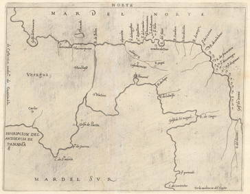
Vaugondy, Map Spain, [1757-58][Spain]. Robert de Vaugondy. Partie Meridionale Des Etats De Castille. Double-page engraved map of Castille, Andalucia, Grenada, and other provinces in central, eastern, and southern Spain. Mr. RobertSee Sold Price
SoldFSPA Robert de Vaugondy (Gilles) Royaumes d'EspagnFSPA Robert de Vaugondy (Gilles) Royaumes d'Espagne et de Portugal, par le Sr. Robert Geographe ordinaire du Roy. Av.map of Spain and Portugal, including Majorca and part of the northern coastSee Sold Price
Gilles Robert de Vaugondy (French, 1688–1766),Gilles Robert de Vaugondy (French, 1688–1766)HISPANIA ANTIQUA AND LA JUDÉE OU TERRE SAINTEtwo colour outlined engraved maps of ancient Spain and the areas comprising the current countries oSee Sold Price
Etats de la Couronne d'Aragon… Catalonia Catalunya. NE Spain VAUGONDY 1752 mapTITLE OF MAP (NOT PRINTED ON THE PAGE):'Etats de la Couronne d'Aragon, ou se trouvent les Royaumes d'Aragon et de Navarre, la Principauté de Catalogne. Par le Sr. Robert de Vaugondy fils GeographSee Sold Price
SoldDe Vaugondy map of New Spain 1778Title: Nouvelle Espagne, Nouveau Mexique, Isles Antilles Author: De Vaugondy, Robert Description: Copper-engraved map, hand-colored in outline. 23.8x30.8 cm. (9½x12").Central America, northern SouthSee Sold Price
Sold[Early Louisiana Map] Robert de Vaugondy, 1762[Early Louisiana Map] Robert de Vaugondy, 1762, Paris, @Canada, Louisiane, Possessions Angl,@ hand colored, decorative title cartouche, featuring the colonial possessions of France, England and SpainSee Sold Price
SoldNew Spain, New Mexico & Caribbean 1795Title: Nouvelle Espagne, Nouveau Mexique, Isles Antilles. Par Robert de Vaugondy Corriges par le Cen. Lamarche... l'An 3 Author: Delamarche, Charles Francois Description: Copper-engraved map, hand-colSee Sold Price
Folio of 1749 Vaugondy Map of Navarre, SpainDescription: Folio of 1749 Vaugondy map of Navarre, Spain, depicting Pamplona and Basque Country. Folio numbered 127 in upper right corner. This map was originally published by Gilles Robert de VaugonSee Sold Price
Folio of 1749 Vaugondy Map of Navarre, SpainDescription: Folio of 1749 Vaugondy map of Navarre, Spain, depicting Pamplona and Basque Country. Folio numbered 127 in upper right corner. This map was originally published by Gilles Robert de VaugonSee Sold Price
Folio of 1749 Vaugondy Map of Navarre, SpainDescription: Folio of 1749 Vaugondy map of Navarre, Spain, depicting Pamplona and Basque Country. Folio numbered 127 in upper right corner. This map was originally published by Gilles Robert de VaugonSee Sold Price
SoldMap, Robert de Vaugondy, Orbis VetusRobert de Vaugondy, "Orbis Vetus," 1752 (later reprint), copper engraving map with hand-coloring, depicting double hemisphere, overall (framed): 26"h x 34.5"wSee Sold Price
Sold3 Maps: Robert de Vaugondy, [ca. 1750's].[Europe/Italy/Scandanavia]. 3 Maps by Robert de Vaugondy, [ca. 1750’s]. Upper & lower margins narrow (approximating 1 map's lower plate mark, but other plate marks are unaffected). Very good. ++ LESSee Sold Price
Sold[MAP] [ROBERT DE VAUGONDY, GILLES] Parte de la Me[MAP] [ROBERT DE VAUGONDY, GILLES] Parte de la Mer du Nord ou se trouvent Les Grandes et Las Petites Isles Antilles et les Isles Lucayes. Engraved map, partly colored by hand. 20 1/2 x 25 inches. FramSee Sold Price
SoldMap, Robert de VaugondyRobert de Vaugondy (French, 1688-1766), "Amerique Septentrionale, dressee, sur les Relations les plus Modernes des Voyaeurs et Navigateurs," copper engraved map with hand coloring, later printing, oveSee Sold Price
SoldMap, Robert de VaugondyRobert de Vaugondy (French, 1688-1766), "Royaume d'Irlande divise en ses quatre Provinces," 1750, hand-colored engraving, sight (image): 19.5"h x 21.5"w, overall (with frame): 27"h x 29"w. Provenance:See Sold Price
Sold[Louisiana Map] Robert de Vaugondy, 1749[Louisiana Map], "Cours du Mississipi et la Louisiane", hand-colored engraved map, by Robert de Vaugondy, 1749, sheet 9 1/2 in. x 7 inSee Sold Price
SoldMap- Robert de Vaugondy (1723-1786). "AmeriqueMap- Robert de Vaugondy (1723-1786). "Amerique Septentrionale," 1750, hand colored, with a cartouche of Tropical plants, natives and wildlife surrounding the title, shrink wrapped, H.- 21 3/8 in., W.-See Sold Price
SoldMap, Robert de VaugondyRobert de Vaugondy (French, 18th Century), "Partie Septentrionale La Couronne de Castille, ou se Trouvent les Royaumes de Castille Vieille de Leon, de Gallice des Asturies la Biscaye et la Navarre, enSee Sold Price
SoldMap, Robert de VaugondyRobert de Vaugondy (French, 18th Century), "Partie Septentrionale La Couronne de Castille, ou se Trouvent les Royaumes de Castille Vieille de Leon, de Gallice des Asturies la Biscaye et la Navarre, enSee Sold Price
Britannia Map, Robert de Vaugondy, 1750Framed hand-colored map of Britannia, by Nicolao Sanson and Robert de Vaugondy, dated 1750. Latin: Britannicae, Insula. Measures 20.75" x 22.5". Framed and matted measurement 30.25" x 31.5".See Sold Price
Antique Arabian Map Robert De Vaugondy 1753Antique Arabian peninsula and Turkey printed by Robert de Vaugondy. Ornamental title on the lower left corner of two figures. Title: Etats Due Grand-Seigneur En Asie, Empire De Perse, Pays Des Usbecs,See Sold Price
SoldEUROPEAN 18TH CENTURY MAP, ROBERT DE VAUGONDYSight- 20" x 26 3/4" Overall- 29 3/4" x 36 3/4"See Sold Price
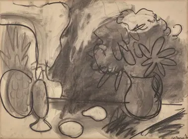
Robert De Niro, Sr. (American, 1922-1993) - Still Life with PitcherFreeman's | Hindman4.5(158)See Sold PriceFeb 28, 2024
THE GODFATHER PART II (1974) - Vito Corleone's (Robert De Niro) Photo-Matched Pea CoatPropstore4.2(6)See Sold PriceMar 12, 2024
Buffon, Vaugody & Bell 1785 America - Map of the New ContinentAlbion Auctions4.6(336)See Sold PriceMar 01, 2024
Buffon, Vaugody & Bell 1785 Map of the Old Continent. Africa, AsiaAlbion Auctions4.6(336)See Sold PriceMar 01, 2024
Guthrie, William 1812 Antique Map. Spain and PortugalAlbion Auctions4.6(336)See Sold PriceMar 01, 2024
Robert Benard (1734 - 1777) - Set of 9 Copperplate Engravings - Greek and Roman architecture - ViewProverde Auctions4.3(3)See Sold PriceFeb 28, 2024
Robert Benard (1734 - 1777) - Set of 9 Copperplate Engravings - Architecture, Masonry, Quarry withProverde Auctions4.3(3)See Sold PriceFeb 28, 2024
Robert Benard (1734 - 1777) - Set of 9 Chemical Engravings - Alchemical symbols - Utensils forProverde Auctions4.3(3)See Sold PriceFeb 28, 2024
Robert de Vaugondy - Map of Canada - Mer de l' Ouest or Sea of the West and a Northwest PassageProverde Auctions4.3(3)See Sold PriceFeb 28, 2024


![Vaugondy, Map Spain, [1757-58] (1 of 1)](https://p1.liveauctioneers.com/179/14187/4432473_1_x.jpg?height=282&quality=70&version=1193335524)


![[Early Louisiana Map] Robert de Vaugondy, 1762 (1 of 1)](https://p1.liveauctioneers.com/268/2586/1120905_1_x.jpg?height=282&quality=70)


![3 Maps: Robert de Vaugondy, [ca. 1750's]. (1 of 10)](https://p1.liveauctioneers.com/179/54294/26374862_1_x.jpg?height=282&quality=70&version=1398371595)
![[MAP] [ROBERT DE VAUGONDY, GILLES] Parte de la Me (1 of 1)](https://p1.liveauctioneers.com/292/8142/1390885_1_x.jpg?height=282&quality=70)


![[Louisiana Map] Robert de Vaugondy, 1749 (1 of 9)](https://p1.liveauctioneers.com/268/37426/15796141_1_x.jpg?height=282&quality=70&version=1360261238)