ATLAS of ANTIENT GEOGRAPHY by SAMUEL BUTLER 1843John McInnis Auctioneers,LLC4.6(504)See Sold PriceFeb 24, 2024
18TH C. ANTIQUE MAP: FRENCH & INDIAN WAR, FRAMEDThomaston Place Auction Galleries4.4(389)See Sold PriceFeb 24, 2024
Rand McNally Railroad Map Cabinet w/ 21 Railroad MapsRail & Road Auctions4.6(165)See Sold PriceMar 08, 2024
Keith Haring - Ink on New York Map, Best Buddies, Inscribed, Signed, and DatedSapphire Auction Gallery4.1(67)See Sold PriceMar 02, 2024
LATE 17TH C. FRENCH MAP OF THE NEW WORLD BY ALEXIS-HUBERT JAILLOT (1632-1712)Thomaston Place Auction Galleries4.4(389)See Sold PriceFeb 24, 2024
Central Railroad of New Jersey Map of Sandy Hook Route-ca. 1903JM Hobby Supply and Railroad Artifact Auctions4.4(126)See Sold PriceFeb 24, 2024
Lot of Six Mixed Atlas Box Cars-HO Scale-New in BoxJM Hobby Supply and Railroad Artifact Auctions4.4(126)See Sold PriceFeb 25, 2024
Rand McNally/Santa Fe Railroad Map of Iowa-1912JM Hobby Supply and Railroad Artifact Auctions4.4(126)See Sold PriceFeb 24, 2024
NICOLAES VISSCHER (NETHERLANDS, 1618-1709) MAP OF THE NEW WORLDThomaston Place Auction Galleries4.4(389)See Sold PriceFeb 24, 2024
17TH C. WORLD MAP BY NICOLAES VISSCHER (NETHERLANDS, 1618-1709)Thomaston Place Auction Galleries4.4(389)See Sold PriceFeb 24, 2024
Lot of Six Mixed Atlas Cabooses-HO Scale-New in BoxJM Hobby Supply and Railroad Artifact Auctions4.4(126)See Sold PriceFeb 25, 2024
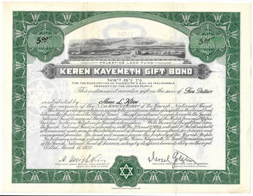
SoldMap of Palestine With the Hauran, 1852Map: Palestine With the Hauran and the Adjacent Districts Maker: Charles Knight/george Cox/SDUK, Walker, J. & C./W. Hughes/Robinson/Burckhardt/Jacotin Publication Date: 1852 Publisher: Charles Knight/See Sold Price
SoldTallis, John (Pub) 1852 Map. Ancient PalestineSteel Engraved Map with Original Outline Hand Color Published 1852-56 by John Tallis, London for "The Universal Pronouncing Dictionary" by Thomas Wright. Drawn & Engraved by John Rapkin. Centre fold aSee Sold Price
SoldTallis, John (Pub) 1852 Map. Modern PalestineSteel Engraved Map with Original Outline Hand Color Published 1852-56 by John Tallis, London for "The Universal Pronouncing Dictionary" by Thomas Wright. Drawn & Engraved by John Rapkin. Centre fold aSee Sold Price
SoldPelton's 1852 Outline Map of AsiaHand colored lithograph, with both original ebonized wood hangers. Published by Sower & Barnes, Philadelphia, with insert map of Palestine. 79" x 67".See Sold Price
Syria (North Division) | Syria (South Division)Reserve Reduced! Title: Syria (North Division) | Syria (South Division) Including Palestine & the Hauran. Publication Date: 1860 Cartographer: HUGHES, W. Publisher: BLACKIE & SON Size (inches): 19.8HeSee Sold Price
SoldGoldsmith, J. 1852 Lot of 15 Maps and Prints6 Maps of Africa, Canaan/Palestine, Asia, Central Europe, British Isles, and Europe. Together with 9 Prints showing Astronomy, Brunei/New Zealand/Sydney, Cairo/Egypt/Algiers, New York/North American ISee Sold Price
SoldNarrative of a Journey Through Syria and Palestine inNarrative of a Journey Through Syria and Palestine in 1851 and 1852, by Charles William Meredith van de Velde, published by William Blackwood and Sons, Edinburgh, 1854. First English edition in two voSee Sold Price
SoldA VINTAGE MAP, "1852 Map of the State of Texas," MIDA VINTAGE MAP, "1852 Map of the State of Texas," MID 20TH CENTURY, ink on paper, "Published 1961, by Highlands Historical Press, Facsimile of the Original, Dallas, Texas." 8" x 11"See Sold Price
SoldANTIQUE MAP "PALESTINE"By Johnson and Ward. With hand coloring. Dimensions: (Frame) H 21.5" x W 17", (Sight) H 16" x W 12.75" Condition: Toning. Handling wear including rubs to frame.See Sold Price
State of the Surveys in The State of Florida Map, 1852Map: A Plate Exhibiting the State of the Surveys in The State of Florida Publisher: Surveyor General's Office, Putnam, B.A. (Surveyor General), 1852Size: Double Folio – 22.30 H x 25.00 W Inches MapSee Sold Price
SoldToms & Cellarius 1789 Map. Palestine, Israel"Palaestina sev Terra Sancta" Copper Engraved Map Published 1789, London for "Geographia Antiqua" Engraved W. H. Toms after an earlier map by Christoph Cellarius. Centre fold as published. Paper Size:See Sold Price
Sold1887 Hand Colored Map Palestine & Environs of Jerusalem1887 Hand Colored Engraving "Map of Palestine" with an inset of the "Environs of Jerusalem"Signed in plate: Bradley 1887Size: Approximately 8 1/4" x 11 1/4"Condition: A fSee Sold Price
SoldMAP, 1852 CENTRAL AMERICA, TEXAS, CALIFORNIAFramed map, c. 1852, "Central America including Mexico, Texas and California", attributed to George Phillip and Son, Liverpool, hand colored, area West of the Mississippi is detailed with rivers and sSee Sold Price
British Islands in The West Indies Map, 1852The British Islands in The West Indies. George Cox/Charles Knight, Society for the Diffusion of Useful Knowledge/ S.D.U.K. | J. & C. Walker. George Cox/Charles Knight. 1852. "Published under the superSee Sold Price
SoldPhelps' National Map 1852Heading: Author: Thayer, Horace & Co. Title: Phelps's National Map of the United States, a Travelers Guide. Embracing the Principal Railroads, Canals, Steamboat & Stage Routes Throughout the Union PlSee Sold Price
SoldS.F. Manual of Corporation with 2 maps 1852Heading: (San Francisco) Author: Title: Manual of the Corporation of the City of San Francisco containing A Map of The City; The Declaration of Independence; The Constitution of The United States; ThSee Sold Price
SoldANTIQUE INDIAN TERRITORY MAP 1852 GEORGE McCLELLANAntique map reading in part: "Map of the Country Upon Upper Red River Explored in 1852 by Capt. R.B. March, 5th U.S. Infy assisted by Bvt. Capt. G.B. McClellan U.S. Engs, under orders from the Head QuSee Sold Price
SoldPropaganda Poster URNA Map Palestine RefugeesOriginal vintage Map of URNA Areas of Operation - The Gaza Strip - Lebanon. Created in December 1949, the United Nations Relief and Works Agency for Palestine Refugees in the Near East (UNRWA) is a reSee Sold Price
Soldmap, Palestine, MaginiFramed hand colored engraved map of Palestine, ''Palaestina, Vel Terra Sancta,'' 18th century, after Giovanni Antonio Magini (Italian, 1555-1617), sight: 5.75''h x 7.25''w, overall: 15''h x 13''wSee Sold Price
THE GREAT METROPOLIS - Phelps New York Map 1852, FramedThe Great Metropolis. Phelp’s New York City Guide, published 1852, 24” x 19” map depicting Central Park and New York City streets from Battery Park to 131st Street. The two color map is double mSee Sold Price
SoldPropaganda Poster URNA Map Palestine RefugeesOriginal vintage Map of URNA Areas of Operation - The Gaza Strip - Lebanon. Created in December 1949, the United Nations Relief and Works Agency for Palestine Refugees in the Near East (UNRWA) is a reSee Sold Price
SoldRare Missouri railroad map 1852Heading: Author: Hutawa, Julius Title: Map of the Lands granted to the State of Missouri by Act of Congress appd. June 10th, 1852, and by Act of the Mo. Legislature appd. Dec. 25th, 1852 to the PacifSee Sold Price
Sold1824 Zadock Thompson w map & 1852 Appendix1824 Zadock Thompson A Gazetteer of the State of Vermont containing a brief general view of the state, A Historical and topographical. Montpelier published by E P Walton and the author. Containing oriSee Sold Price
SoldBrass Curved Hip Flask with Palestine Map, Palestine,Brass Curved Hip Flask with Palestine Map, Palestine, Early 20th Century.Engraved with the map of Palestine including the location of cities as Haifa, Tel-Aviv, Jaffa, Jerusalem, Nazareth, and Beth LeSee Sold Price
Archaeological Books - Roach Smith - Collectanea Antiqua, etchings and notices of ancient remains,TimeLine Auctions Ltd.4.6(182)See Sold PriceMar 06, 2024
Jerusalem Map for British Soldiers in Palestine - WW2Levy Auction House4.3(11)See Sold PriceFeb 27, 2024
Proposed Sportsground Map - Haifa, Palestine - 1926Levy Auction House4.3(11)See Sold PriceFeb 27, 2024
Caravan Routes in Palestine Linen Map - Germany, 1881Levy Auction House4.3(11)See Sold PriceFeb 27, 2024
The Holy Land Tours - Hamburg American Line - 1911Levy Auction House4.3(11)See Sold PriceFeb 27, 2024
18 Booklets Collection - War Graves of Palestine - WWILevy Auction House4.3(11)See Sold PriceFeb 27, 2024
Illustrated Sabbath Cloth - Holy Sites of Eretz IsraelLevy Auction House4.3(11)See Sold PriceFeb 27, 2024
Vaillant - Hawaii: Stranding in the Sandwich Islands (Echouage aux Iles Sandwich). 43Trillium Antique Prints & Rare Books4.5(30)See Sold PriceFeb 24, 2024
Vaillant - Honolulu, Hawaii (Vue de Honolulu, Iles Sandwich). 45Trillium Antique Prints & Rare Books4.5(30)See Sold PriceFeb 24, 2024
Vaillant - Hawaiian Dance (Scene de Danse aux Iles Sandwich). 42Trillium Antique Prints & Rare Books4.5(30)See Sold PriceFeb 24, 2024
Perry, Matthew C. 1856 Large Map. Shah Bay, Lew Chew I. JapanAlbion Auctions4.6(341)See Sold PriceMar 01, 2024
Carl Johan Billmark - Set of 4 Prints depicting Rome, Italy - Church in Sweden - Views of EuropeProverde Auctions4.3(3)See Sold PriceFeb 28, 2024