ATLAS of ANTIENT GEOGRAPHY by SAMUEL BUTLER 1843John McInnis Auctioneers,LLC4.6(502)See Sold PriceFeb 24, 2024
18TH C. ANTIQUE MAP: FRENCH & INDIAN WAR, FRAMEDThomaston Place Auction Galleries4.4(386)See Sold PriceFeb 24, 2024
Rand McNally Railroad Map Cabinet w/ 21 Railroad MapsRail & Road Auctions4.6(165)See Sold PriceMar 08, 2024
Keith Haring - Ink on New York Map, Best Buddies, Inscribed, Signed, and DatedSapphire Auction Gallery4(67)See Sold PriceMar 02, 2024
LATE 17TH C. FRENCH MAP OF THE NEW WORLD BY ALEXIS-HUBERT JAILLOT (1632-1712)Thomaston Place Auction Galleries4.4(386)See Sold PriceFeb 24, 2024
Central Railroad of New Jersey Map of Sandy Hook Route-ca. 1903JM Hobby Supply and Railroad Artifact Auctions4.4(126)See Sold PriceFeb 24, 2024
Lot of Six Mixed Atlas Box Cars-HO Scale-New in BoxJM Hobby Supply and Railroad Artifact Auctions4.4(126)See Sold PriceFeb 25, 2024
Rand McNally/Santa Fe Railroad Map of Iowa-1912JM Hobby Supply and Railroad Artifact Auctions4.4(126)See Sold PriceFeb 24, 2024
NICOLAES VISSCHER (NETHERLANDS, 1618-1709) MAP OF THE NEW WORLDThomaston Place Auction Galleries4.4(386)See Sold PriceFeb 24, 2024
17TH C. WORLD MAP BY NICOLAES VISSCHER (NETHERLANDS, 1618-1709)Thomaston Place Auction Galleries4.4(386)See Sold PriceFeb 24, 2024
Lot of Six Mixed Atlas Cabooses-HO Scale-New in BoxJM Hobby Supply and Railroad Artifact Auctions4.4(126)See Sold PriceFeb 25, 2024
SoldMap, holy land, Palestine, by Abraham Ortelius, 1612Early map, Palestine, holy land, by Abraham Ortelius, published in Antwerp, 1612, 14.5" by 18.5"See Sold Price
Map of Palestine & Holy LandOriginal engraving by Bradford, 1835. Please note that this lot has a confidential reserve. When you leave a bid in advance of the auction, submit your maximum. Jasper52 will bid on your behalf as mucSee Sold Price
SoldANTIQUE MAP OF PALESTINE HOLY LAND PALESTINE JudaicaANTIQUE MAP OF PALESTINE HOLY LAND PALESTINE Judaica Size 12 1/2 by 10" Very good condition, folds. Reserve: $10.00 Shipping: Domestic: Flat-rate of $10.00 to anywhere within the contiguous U.S. InterSee Sold Price
Great map of Palestine from scarce 1833 Finley atlasScarce map of Palestine (Israel, Holy Land) from Anthony Finley’s 1833 New General Atlas, an exceedingly scarce atlas. Maps from later Finley atlases are rarely available. Shows the lands ascribSee Sold Price
Sold86: HAND COLORED ENGRAVED MAP, PALESTINE/HOLY LANDSHAND COLORED ENGRAVED MAP, PALESTINE AND THE HOLY LANDS, SIGNED MATTHAUS SEUTTER (GERMAN 1678-1757) 18TH CENTURY. PLATE 20 X 23 1/4 (LAID DOWN; EDGE SHEET CHIPS) **NO IN-HOUSES SHIPPING**See Sold Price
SoldMitchell: A New Map of Palestine or the Holy Land, 1867Map: A New Map of Palestine or the Holy Land Cartographer: S. A. Mitchell Place & Date: Philadelphia / 1867/1870 Size: 11 5/8" x 14 1/8" Condition: full color; light overall age toning The beautifullySee Sold Price
SoldHistorical Map of Palestine or The Holy LandHistorical map of Palestine, or the Holy Land, published by Samuel Augustus Mitchell, Philadelphia, framed 45" x 33". Provenance: New York, New York collection.See Sold Price
New Map of Palestine Or the Holy Land.Title: New Map of Palestine Or the Holy Land. Date: 1884 Cartographer: GAMBLE, W. H. Publisher: MITCHELL, S.A. Size: 13.5Height - 11.5Width Map with inset: Modern Jerusalem. Details topography, towns,See Sold Price
Sold(4) Maps of Palestine 19th c.Includes: A New Map of Palestine of the Holy Land. 12 3/8" x 15" folded, Mitchell 1867. Hocland von Juda 10 5/8" x 16 3/8" Andreas Atlas 1893 (p.109). Palestine 13 5/8" x 20 3/8" folded, Appleton 1891See Sold Price
SoldDUTCH HAND-COLORED MAP HOLY LAND, STOOPENDAALFramed hand-colored engraving on paper, Map of Canaan (Israel, Palestine, Holy Land), Amsterdam, Daniel Stoopendaal (1672-1726), sight: approx 12"h, 17.5"w, overall: approx 18"h, 23"w, 3.75lbs Start PSee Sold Price
SoldMonumental Christian Holy Land MapGilbert, James (fl. c. 1839-1850). Gilbert's Map of Palestine and the Countries Adjacent. Engraved map. J. Gilbert, 1849. 32" x 36 ¼" sheet. "...A map of Palestine or the Holy Land, with Egypt andSee Sold Price
Samuel Augustus Mitchell (1790-1868), "A New Map ofSamuel Augustus Mitchell (1790-1868), "A New Map of Palestine or the Holy Land," 1867, hand colored, H.-12 1/4 in., W.- 15 3/8 in.See Sold Price
Assheton (J.T.) A Historical Map of Palestine, orAssheton (J.T.) A Historical Map of Palestine, or the Holy Land,engraved map, by Sidney Hall, with biblical vignettes throughout, 1090 x 730mm, horizontal fold with creases and browning, surfaSee Sold Price
SoldSeaton (Robert) Seaton's Map of Palestine or the HSeaton (Robert) Seaton's Map of Palestine or the Holy Land, with Part of Egypt,showing the Holy Land, Sinai and Lower Egypt, illustrated with a scene of Christ and the woman of Samaria, plansSee Sold Price
Mitchell: Antique Map of Palestine, 18641864 hand-colored map of Palestine by S. Augustus Mitchell. A beautiful example of S. A. Mitchell Jr.'s 1864 map of Palestine, Israel or the Holy Land. Updated from the 1860 variant with new details,See Sold Price
Sold1864 hand-colored map of Palestine by S. AugustusA beautiful example of S. A. Mitchell Jr.'s 1864 map of Palestine, Israel or the Holy Land. Updated from the 1860 variant with new details, an inset of Jerusalem, and a new 1864 copyright. Includes boSee Sold Price
1899 Rand McNally Map of Holy Land -- PalestineTitle: 1899 Rand McNally Map of Holy Land -- Palestine Cartographer: Rand McNally Year/Place: 1899, Chicago Dimensions: 18.6 x 12.3 in. when combined Description: This is a highly detailed, double pagSee Sold Price
Alexis Hubert Jaillot (1632-1712): Map of Holy LandAlexis Hubert Jaillot: Map of Holy Land, engraving, map showing Ancient Palestine, Judea and the Holy Land from “Atlas Nouveau,” published by Jaillot in Paris, 1696, edited by Pierre Mortier. AlexSee Sold Price
1750 Homann Map of Holy Land/Palestine -- Palestina in XII Tribus Divisa…Title: 1750 Homann Map of Holy Land/Palestine -- Palestina in XII Tribus Divisa… Cartographer: J. Homann Year / Place: 1750 Nurnberg Map Dimension (in.): 18.8 X 20.9 in. This is an excellent mapSee Sold Price
1750 Homann Map of Holy Land/Palestine -- Palestina inTitle: 1750 Homann Map of Holy Land/Palestine -- Palestina in XII Tribus Divisa… Cartographer: J. Homann Year / Place: 1750 Nurnberg Map Dimension (in.): 18.8 X 20.9 in. This is an excellent map ofSee Sold Price
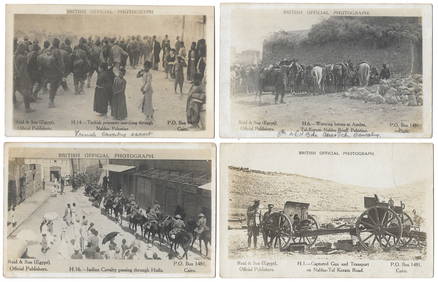
14 Official British Army Postcards - Palestine in WWILevy Auction House4.3(11)See Sold PriceFeb 27, 2024
Jerusalem Map for British Soldiers in Palestine - WW2Levy Auction House4.3(11)See Sold PriceFeb 27, 2024
Proposed Sportsground Map - Haifa, Palestine - 1926Levy Auction House4.3(11)See Sold PriceFeb 27, 2024
Caravan Routes in Palestine Linen Map - Germany, 1881Levy Auction House4.3(11)See Sold PriceFeb 27, 2024
Excursions to Palestine - Thomas Cook - 19th CenturyLevy Auction House4.3(11)See Sold PriceFeb 27, 2024
The Holy Land Tours - Hamburg American Line - 1911Levy Auction House4.3(11)See Sold PriceFeb 27, 2024
18 Booklets Collection - War Graves of Palestine - WWILevy Auction House4.3(11)See Sold PriceFeb 27, 2024
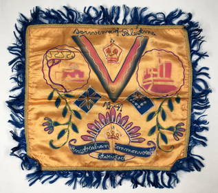
Illustrated Sabbath Cloth - Holy Sites of Eretz IsraelLevy Auction House4.3(11)See Sold PriceFeb 27, 2024
1849 Mitchell School ATLAS 24 MAPS America Holy Land France Africa Egypt AsiaSchilb Antiquarian Rare Books4.8(421)See Sold PriceMar 31, 2024
1872 Holy BIBLE & Hitchcock Analysis Gruden Concordance Theology MAPS Holy LandSchilb Antiquarian Rare Books4.8(421)See Sold PriceMar 31, 2024
1886 Cities of BASHAN Holy Land SYRIA Palestine Israel Jerusalem History BibleSchilb Antiquarian Rare Books4.8(421)See Sold PriceMar 31, 2024
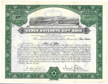
TWO ANTIQUE JEWISH NATIONAL FUND CHARITY BOXES. The first one made in Berlin c. 1920J. Greenstein & Co., Inc.4.3(55)See Sold PriceApr 16, 2024