ATLAS of ANTIENT GEOGRAPHY by SAMUEL BUTLER 1843John McInnis Auctioneers,LLC4.6(502)See Sold PriceFeb 24, 2024
18TH C. ANTIQUE MAP: FRENCH & INDIAN WAR, FRAMEDThomaston Place Auction Galleries4.4(386)See Sold PriceFeb 24, 2024
Rand McNally Railroad Map Cabinet w/ 21 Railroad MapsRail & Road Auctions4.6(165)See Sold PriceMar 08, 2024
Keith Haring - Ink on New York Map, Best Buddies, Inscribed, Signed, and DatedSapphire Auction Gallery4(67)See Sold PriceMar 02, 2024
LATE 17TH C. FRENCH MAP OF THE NEW WORLD BY ALEXIS-HUBERT JAILLOT (1632-1712)Thomaston Place Auction Galleries4.4(386)See Sold PriceFeb 24, 2024
Central Railroad of New Jersey Map of Sandy Hook Route-ca. 1903JM Hobby Supply and Railroad Artifact Auctions4.4(126)See Sold PriceFeb 24, 2024
Lot of Six Mixed Atlas Box Cars-HO Scale-New in BoxJM Hobby Supply and Railroad Artifact Auctions4.4(126)See Sold PriceFeb 25, 2024
Rand McNally/Santa Fe Railroad Map of Iowa-1912JM Hobby Supply and Railroad Artifact Auctions4.4(126)See Sold PriceFeb 24, 2024
NICOLAES VISSCHER (NETHERLANDS, 1618-1709) MAP OF THE NEW WORLDThomaston Place Auction Galleries4.4(386)See Sold PriceFeb 24, 2024
17TH C. WORLD MAP BY NICOLAES VISSCHER (NETHERLANDS, 1618-1709)Thomaston Place Auction Galleries4.4(386)See Sold PriceFeb 24, 2024
Lot of Six Mixed Atlas Cabooses-HO Scale-New in BoxJM Hobby Supply and Railroad Artifact Auctions4.4(126)See Sold PriceFeb 25, 2024
SoldTallis, John (Pub) 1852 Map. New ZealandSteel Engraved Map with Original Outline Hand Color Published 1852-56 by John Tallis, London for "The Universal Pronouncing Dictionary" by Thomas Wright. Drawn & Engraved by John Rapkin. Centre fold aSee Sold Price
SoldGross, Alexander 1920 Lot of 4 Large Maps. New ZealandLarge Lithograph Maps Published 1920, London for "The Daily Telegraph Victory Atlas of the World" by Alexander Gross. Centre fold as published. Paper Size: 25 x 19.5 inch (64 x 49cm) Good ConditionSee Sold Price
SoldBartholomew, John 1922 Pair Maps. New Zealand & Pacific"New Zealand" and "Islands of Oceania" The latter showing Hawaii and other Pacific Islands. Large Lithograph Maps Published 1922 by The Times, London for "The Times Survey Atlas of the World" Maps bySee Sold Price
SoldZatta: Antique Map of New Zealand, 1783Title/Content of Map: New Zealand by Zatta Date Printed: 1783 Cartographer: Antonio Zatta Material/Medium: Paper Size: 16" x 22" Hand colored. Copperplate engraved. Published in Venice. Antonio ZattaSee Sold Price
SoldNEW ZEALAND. Shows NZ Company settlements in 1851.TITLE/CONTENT OF MAP: 'New Zealand' Vignettes: Auckland; Mount Egmont from New Plymouth; Wellington. North Island is indicated as "New Ulster or North Island"; the island known today as South Island iSee Sold Price
New Zealand North Island. New Ulster Map, 1863TITLE/CONTENT OF MAP: 'New Zealand North Island New Ulster or Eaheinomauwe' DATE PRINTED: 1863 IMAGE SIZE: Approx 45.0 x 32.5cm, 17.75 x 12.75 inches (Large) TYPE: Antique map with original outline coSee Sold Price
SoldNew Zealand 1897Title/Content of Map: New Zealand 1897 Date Printed: 1897 Material/Medium: paper Size: approx. 10.5x 13.5 inches Cram's Universal Atlas Geographical, Astronomical and Historical Atlas Reserve: $20.00See Sold Price
SoldBryce, James 1881 Map of New ZealandLithograph Map Published 1881, London for ""The International Atlas and Geography..." by James Bryce. Maps by Edward Weller & John Bartholomew. Uncommon. Paper Size: 18 x 13 inch (46 x 33cm) Good CondSee Sold Price
John Bartholomew: Map of New Zealand, 1898Map: New Zealand Maker: John Bartholomew From The Citizen's Atlas Date: 1898 Size: 14 x 18 inches Please note that this lot has a confidential reserve. When you leave a bid in advance of the auction,See Sold Price
SoldMap of New Zealand, North Island, 1902Title: Map of New Zealand, North Island Original engraving by George Cram Date: 1902 Dimensions: 11 x 14 inches No Reserve: This lot starts at $1 and has no reserve as a courtesy so that collectors caSee Sold Price
SoldMap of New Zealand, South Island, 1902Title: Map of New Zealand, South Island (Chatham & Tasmania) Original engraving by George Cram Date: 1902 Dimensions: 11 x 14 inches Description: Features insets of Chatham Islands & Tasmania on Van DSee Sold Price
Sold1844 Map of New ZealandAuthor: Hughes Title: 1844 Map of New Zealand Materials: Ink on Paper Dimensions: 12.5"X17" Description: Map date 1844. Drawn by W. Hughes. Published by A. C. Black in London and then Edinburgh. ThisSee Sold Price
SoldRapkin, John 1860 Antique Map of New ZealandSteel Engraved Map Published 1860 by The London Printing & Published Company, London for "The Royal Dictionary-Cyclopedia for Universal Reference" by Thomas Wright. Drawn & Engraved by John Rapkin. FoSee Sold Price
SoldBartholomew, John 1922 Large Map of New ZealandLarge Lithograph Map Published 1922 by The Times, London for "The Times Survey Atlas of the World" Maps by John George Bartholomew of the Edinburgh Geographical Institute. Centre fold as issued. PaperSee Sold Price
SoldBryce, James 1881 Map of New Zealand South IslandLithograph Map Published 1881, London for ""The International Atlas and Geography..." by James Bryce. Maps by Edward Weller & John Bartholomew. Uncommon. Paper Size: 18 x 13 inch (46 x 33cm) Good CondSee Sold Price
Sold1871 Map of New ZealandAuthor: Bartholomew Title: 1871 Map of New Zealand Medium: Ink on Paper Dimensions: 10.5"X13" Map of New Zealand dated 1871. Engraved for John Bartholomew and co. Published in Edinburgh and London. KeSee Sold Price
Sold1882 Map of New ZealandAuthor: Blackie Title: 1882 Map of New Zealand Medium: Ink on Paper Dimensions: 15"X22" Map of New Zealand dated 1882. Part of the Comprehensive Atlas & Geography of the World. Engraved by Edwin WelleSee Sold Price
SoldBryce, James 1881 Map of New Zealand North IslandLithograph Map Published 1881, London for ""The International Atlas and Geography..." by James Bryce. Maps by Edward Weller & John Bartholomew. Uncommon. Paper Size: 18 x 13 inch (46 x 33cm) Good CondSee Sold Price
SoldButler, George 1874 Pair of Maps. Australia New ZealandLithograph Maps Published 1874, London for "The Public School Atlas of Modern Geography" by Rev. George Butler. Paper Size: 11 x 7 inch (28 x 17cm) Good ConditionSee Sold Price
SoldReinecke: Australia/ New Zealand/ Hawaii Map 1804Map: Australia/ New Zealand/ Hawaii/ South Pacific "General Charte von Australien" Publishing: Reinecke, Johann Matthias: Weimar Date: 1804 Size: 17.75 x 24 inches An uncommon map described by TooleySee Sold Price
SoldNEW ZEALAND 1851 FRAMED HAND COLORED MAPEngraved map of New Zealand 1851. J Rapkin, the illustrations by H. Warren & engraved by J. B. Allen . Hand colored with decorative border, inset vignette views.. Image 10 x 26 inches. Overall 14 1/2See Sold Price
SoldColton: Antique Map of Hawaii, New Zealand, 1859Title/Content of Map: Hawaii, New Zealand & other islands Date Printed: 1859 Cartographer: H.J. Colton Material/Medium: Paper Size: 17 1/2" x 15" Hand colored engraved Map. Publsihed in New York in 'CSee Sold Price
SoldIndian Ocean Map 1941Indian Ocean Map : Australia, New Zealand and Malaysia. National Geographic magazine. Date: 1941. Editor: Gilbert Grosvenor. Measurement approximate: 25 x 32. Shipping cost: $15.00 excluding Hawaii, ASee Sold Price
"La Nuova Zelanda trascora nel 1769 e 1770 dal Cook"TITLE/CONTENT OF MAP: 'La Nuova Zelanda trascora nel 1769 e 1770 dal Cook Comandate dell' Endeavour Vascello di S.M. Britannica' An early map of New Zealand showing the route taken by Cook in 1769 andSee Sold Price
1789 Captain James Cook Life & Voyages Australia New Zealand Hawaii KippisSchilb Antiquarian Rare Books4.8(421)See Sold PriceMar 10, 2024
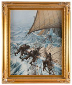
ANTHONY D. (A.D.) BLAKE (New Zealand, 1951-), "Reducing Sail at Sunset"., Oil on canvas, 30" x 24".Eldred's4.7(409)See Sold PriceFeb 27, 2024
ANTHONY D. (A.D.) BLAKE (New Zealand, 1951-), Furling sails in a storm., Oil on canvas, 30" x 24".Eldred's4.7(409)See Sold PriceFeb 27, 2024
ANTHONY D. (A.D.) BLAKE (New Zealand, 1951-), "The Flying Fish and John Gilpin Meet off Cape HornEldred's4.7(409)See Sold PriceFeb 27, 2024
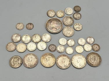
Group of Canada, New Zealand, Australia, Great Britain Silver CoinsDana J. Tharp Auctions4.7(268)See Sold PriceFeb 24, 2024
New Zealand 1 florin King George V, 1933 Silver coinBazaar of Persia4.3(23)See Sold PriceFeb 24, 2024
New Zealand - Maori wooden carved "Tiki" statuette.GOLDFIELD AUCTION4.3(32)See Sold PriceMar 02, 2024
D'Entrecasteaux - Map of Australia (New Holland), New Zealand, and southern Asia and surroundingTrillium Antique Prints & Rare Books4.5(30)See Sold PriceFeb 24, 2024
Cooke, George 1801 Print. Maori Tattoo Man, Warrior of New ZealandAlbion Auctions4.6(336)See Sold PriceMar 07, 2024
Large Group of Mixed Dates UK and Territories Coinage Australia New Zealand Hong KongGCB Estate Sales4.5(86)See Sold PriceMar 02, 2024
4 Antique Engraving Prints of New Zealand IndiansGreenwich Auction4.3(1.4k)See Sold PriceFeb 29, 2024
1934 New Zealand 1 Florin. 50% SilverRichard L. Edwards Auctioneering4.8(2.3k)See Sold PriceFeb 27, 2024