ATLAS of ANTIENT GEOGRAPHY by SAMUEL BUTLER 1843John McInnis Auctioneers,LLC4.6(502)See Sold PriceFeb 24, 2024
18TH C. ANTIQUE MAP: FRENCH & INDIAN WAR, FRAMEDThomaston Place Auction Galleries4.4(386)See Sold PriceFeb 24, 2024
Rand McNally Railroad Map Cabinet w/ 21 Railroad MapsRail & Road Auctions4.6(165)See Sold PriceMar 08, 2024
Keith Haring - Ink on New York Map, Best Buddies, Inscribed, Signed, and DatedSapphire Auction Gallery4(67)See Sold PriceMar 02, 2024
LATE 17TH C. FRENCH MAP OF THE NEW WORLD BY ALEXIS-HUBERT JAILLOT (1632-1712)Thomaston Place Auction Galleries4.4(386)See Sold PriceFeb 24, 2024
Central Railroad of New Jersey Map of Sandy Hook Route-ca. 1903JM Hobby Supply and Railroad Artifact Auctions4.4(126)See Sold PriceFeb 24, 2024
Lot of Six Mixed Atlas Box Cars-HO Scale-New in BoxJM Hobby Supply and Railroad Artifact Auctions4.4(126)See Sold PriceFeb 25, 2024
Rand McNally/Santa Fe Railroad Map of Iowa-1912JM Hobby Supply and Railroad Artifact Auctions4.4(126)See Sold PriceFeb 24, 2024
NICOLAES VISSCHER (NETHERLANDS, 1618-1709) MAP OF THE NEW WORLDThomaston Place Auction Galleries4.4(386)See Sold PriceFeb 24, 2024
17TH C. WORLD MAP BY NICOLAES VISSCHER (NETHERLANDS, 1618-1709)Thomaston Place Auction Galleries4.4(386)See Sold PriceFeb 24, 2024
Lot of Six Mixed Atlas Cabooses-HO Scale-New in BoxJM Hobby Supply and Railroad Artifact Auctions4.4(126)See Sold PriceFeb 25, 2024
SoldMary Bradford Crowninshield ALL AMONG THE LIGHTHOUSESMary Bradford Crowninshield ALL AMONG THE LIGHTHOUSES OR THE CRUISE OF THE GOLDENROD 1886 Decorative Gilt & Silver Binding Illustrated Maine Map New Brunswick Coastal Landscapes & Towns Technical DetaSee Sold Price
SoldNew Brunswick & NewfoundlandTitle/Content of Map: New Brunswick & Newfoundland Date: 1861 Cartographer: Johnson Material/Medium: steel engraved Size: 18x14” Provenance: New York Additional Info: Hand colored Reserve: $15.00See Sold Price
SoldColton: Antique Map of New Brunswick & Nova ScotiaTitle/Content of Map: New Brunswick & Nova Scotia by Colton Date Printed: 1859 Cartographer: H.J. Colton Material/Medium: Paper Size: 17 1/2" x 15" Hand colored, engraved Map. Published in New York inSee Sold Price
SoldMap of New BrunswickThe Home Knowledge Atlas, Toronto 1891. George Cram Size: 22 x 13.5 inches No Reserve: This lot starts at $1 and has no reserve as a courtesy so that collectors can determine the true market value onSee Sold Price
Sold1855 MAP OF NEW BRUNSWICK & NOVA SCOTIAColton's Dominion of Canada No. 3 The Provinces of New Brunswick & Nova Scotia and Prince Edward Island. Sight size 18 x 27, overall 25.5 x 34.5 inches.See Sold Price
SoldColton: Antique Map of New Brunswick, Nova Scotia, 1861Title/Content of Map: Canada, New Brunswick, Nova Scotia and Newfoundland Date Printed: 1861 Cartographer: J.H. Colton Material/Medium: Paper Size: 17 1/4" x 13" Hand colored steel engraved Map from 'See Sold Price
SoldMap of New Brunswick & Nova Scotia, Newfoundland,Original engraving from Johnson's Atlas of the World, 1868. Map details cities, towns and territories. Dimensions: 18" x 26". No Reserve This item ships from Ocean View, DE.See Sold Price
Canada, New Brunswick and Nova Scotia.Map: Canada, New Brunswick and Nova Scotia. Eastern Canada with North West Territory in U. S. Publication Date: 1830 Authors: LONGMAN, REES, ORME, BROWN AND GREEN, HALL, SIDNEY Publisher: LONGMAN, REESee Sold Price
SoldColton Eastern Canada MapMap of New Brunswick, Nova Scotia, Newfoundland, and Prince Edward Island 1857, 17.25 x 14 in Please note that this lot has a confidential reserve. When you leave a bid in advance of the auction, submSee Sold Price
Map of Canada, New Brunswick & Nova Scotia, 1830Map: Canada, New Brunswick & Nova Scotia Maker: Longman, Rees, Orme, Brown and Green, Sydney Hall Date: 1830 Size: Folio, 16.5 inches high x 20.6 inches wide Eastern Canada with North West Territory iSee Sold Price
SoldTallis/ Rapkin: Antique Map East Canada, New BrunswickTitle/Content of Map: 'East Canada and New Brunswick' The map shows the southern part of Quebec and New Brunswick, in districts/counties. Vignettes: North American Indians; Quebec Date Printed: 1851 ISee Sold Price
SoldTallis, John (Pub) 1852 Map East Canada & New BrunswickSteel Engraved Map with Original Outline Hand Color Published 1852-56 by John Tallis, London for "The Universal Pronouncing Dictionary" by Thomas Wright. Drawn & Engraved by John Rapkin. Centre fold aSee Sold Price
SoldCram: Map of Canada New Brunswick & Nova Scotia, 1891Map: Dominion of Canada verso New Brunswick & Nova Scotia Date: 1891 From Cram's "Unrivaled Family Atlas of the World Indexed" TWO Maps, one on each side Size: 14.5 x 11 inches Please note that this lSee Sold Price
SoldGroup of Five (5) 19th Century MapsIncluding England Scotland and Ireland Britain or the United Kingdom published by Cummings & Hillard No. 1 Cornhill Boston, Newfoundland Nova Scotia and New Brunswick map, French map of North America,See Sold Price
SoldLower Canada, New Brunswick, Nova Scotia' Quebec &TITLE/CONTENT OF MAP: 'Lower Canada, New Brunswick, Nova Scotia &c.; Inset map of Newfoundland' DATE PRINTED: 1862 IMAGE SIZE: Approx 31.0 x 45.0cm, 12.25 x 17.75 inches (Large) TYPE: Antique map withSee Sold Price
Bradford: Antique Map of Lower Canada, 1838Map: Lower Canada & New Brunswick Date Printed: 1838/1841 Cartographer: Thomas G. Bradford Material/Medium: Paper Size: 13 x 1/2" x 16 3/4" Hand colored. A General Atlas of the World, with a seperateSee Sold Price
Sold1850 Tallis Map of Quebec and New Brunswick -- EastTitle/Content of Map: 1850 Tallis Map of Quebec and New Brunswick -- East Canada and New Brunswick Date: 1850, London Cartographer: J Tallis Size: 10.5 X 13.5 in. This is quite attractive map of the SSee Sold Price
SDUK: Antique Map of Nova Scotia & New Brunswick, 1844Title/Content of Map: 'NORTH AMERICA, SHEET I., NOVA SCOTIA WITH PART OF NEW BRUNSWICK AND LOWER CANADA' Quebec Prince Edward's Island. Date Printed: This map was originally published by Baldwin & CraSee Sold Price
Mitchell: Antique Map of Canadian Maritimes, 1870Map: County Map of Nova Scotia New Brunswick Cape Breton Id. and Pr. Edward's Id. Cartographer: S. A. Mitchell Place & Date: Philadelphia / 1870 Size: 10 5/8" x 13 3/8" Condition: full color; light ovSee Sold Price
Sold1876 Mitchell Map of Canadian Maritime Provinces --Title/Content of Map: 1876 Mitchell Map of Canadian Maritime Provinces -- County Map of Nova Scotia, New Brunswick, Cape Breton Id. and Prince Edward's Id. Date: 1876 Philadelphia Cartographer: S MitcSee Sold Price
EAST CANADA & NEW BRUNSWICK': Quebec. Québec city view.TITLE/CONTENT OF MAP: 'East Canada and New Brunswick' The map shows the southern part of Quebec and New Brunswick, in districts/counties. Vignettes: North American Indians; Quebec The top image on theSee Sold Price
EAST CANADA & NEW BRUNSWICK. Quebec. Québec city view.TITLE/CONTENT OF MAP: 'East Canada and New Brunswick' The map shows the southern part of Quebec and New Brunswick, in districts/counties. Vignettes: North American Indians; Quebec DATE PRINTED: 1851 ISee Sold Price
Sold1858 Map of Lower Canada and New BrunswickAuthor: Johnson Title: 1858 Map of Lower Canada and New Brunswick Medium: Ink on Paper Dimensions: 18"X13' Map of Lower Canada and New Brunswick dated 1858. Engraved by A.J. Johnson. Published by JohnSee Sold Price
Tallis: Map of East Canada and New Brunswick, 1850Map: Map of East Canada and New Brunswick Maker: John Tallis, J. Rapkin Published: 1850 in London Size: Folio, 10.25 x 13.5 inches Scarce 1st issue before vignette of Bison (lower right) replaced withSee Sold Price
Crams Township and Railroad Map of New York-1890JM Hobby Supply and Railroad Artifact Auctions4.4(126)See Sold PriceFeb 24, 2024
Aiden Lassell Ripley (1896-1969), Dull Day on the RiverCopley Fine Art Auctions4.5(40)See Sold PriceFeb 24, 2024
CHARLES HENRY GIFFORD (Massachusetts, 1839-1904), Luminist view of three sailboats in a quietEldred's4.7(409)See Sold PriceFeb 28, 2024
Crystal Wall Lancaster (Canada,20/21C) acrylic paintingBroward Auction Gallery4.8(277)See Sold PriceApr 14, 2024
Vintage County Map Of NY State Plate EngravingThe Benefit Shop Foundation Inc.4.3(2.9k)See Sold PriceFeb 28, 2024
4 Boy Scout Books from the 1950's to 1960'sNorth American Artifact Auctions4.6(182)See Sold PriceApr 20, 2024
5 Folio Size Books about the West in Fine or Near Fine ConditionNorth American Artifact Auctions4.6(182)See Sold PriceApr 20, 2024
[SHIPWRECKS]. Manuscript testimony (court duplicate) of Thomas Kent, a Black man aboard theFreeman's | Hindman4.4(1.6k)See Sold PriceFeb 27, 2024
[ADVERTISING]. Red Cross Cotton, From Start to Finish. New Brunswick, NJ: Johnson & Johnson, 1894.Freeman's | Hindman4.4(1.6k)See Sold PriceFeb 27, 2024
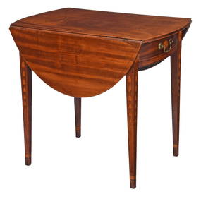
Very Fine American Federal Fan and Bellflower Inlaid Mahogany Pembroke TableBrunk Auctions4.6(463)See Sold PriceMar 08, 2024
Porcelain Lusterware - Hand Painted Souvenir Creamer - Bridge Pool, Riley Brook, New BrunswickRapid Estate Liquidators and Auction Gallery4.5(1.1k)See Sold PriceFeb 24, 2024
Herman Moll A New Map of Ye North Parts of AmericaWillow Auction House4.5(283)See Sold PriceMar 14, 2024
Myotts England - Royal Grafton China - Tea Cup and Saucer - Grand Falls, New BrunswickRapid Estate Liquidators and Auction Gallery4.5(1.1k)See Sold PriceMar 02, 2024
Abstract Painting on Masonite Signed R TamayoEstate Collection Auctioneer4(117)See Sold PriceMar 16, 2024


![[SHIPWRECKS]. Manuscript testimony (court duplicate) of Thomas Kent, a Black man aboard the (1 of 5)](https://p1.liveauctioneers.com/197/319238/171468014_1_x.jpg?height=282&quality=70&version=1707520367)
![[ADVERTISING]. Red Cross Cotton, From Start to Finish. New Brunswick, NJ: Johnson & Johnson, 1894. (1 of 2)](https://p1.liveauctioneers.com/197/319238/171468146_1_x.jpg?height=282&quality=70&version=1707520367)