ATLAS of ANTIENT GEOGRAPHY by SAMUEL BUTLER 1843John McInnis Auctioneers,LLC4.6(502)See Sold PriceFeb 24, 2024
18TH C. ANTIQUE MAP: FRENCH & INDIAN WAR, FRAMEDThomaston Place Auction Galleries4.4(386)See Sold PriceFeb 24, 2024
Rand McNally Railroad Map Cabinet w/ 21 Railroad MapsRail & Road Auctions4.6(165)See Sold PriceMar 08, 2024
Keith Haring - Ink on New York Map, Best Buddies, Inscribed, Signed, and DatedSapphire Auction Gallery4(67)See Sold PriceMar 02, 2024
LATE 17TH C. FRENCH MAP OF THE NEW WORLD BY ALEXIS-HUBERT JAILLOT (1632-1712)Thomaston Place Auction Galleries4.4(386)See Sold PriceFeb 24, 2024
Central Railroad of New Jersey Map of Sandy Hook Route-ca. 1903JM Hobby Supply and Railroad Artifact Auctions4.4(126)See Sold PriceFeb 24, 2024
Lot of Six Mixed Atlas Box Cars-HO Scale-New in BoxJM Hobby Supply and Railroad Artifact Auctions4.4(126)See Sold PriceFeb 25, 2024
Rand McNally/Santa Fe Railroad Map of Iowa-1912JM Hobby Supply and Railroad Artifact Auctions4.4(126)See Sold PriceFeb 24, 2024
NICOLAES VISSCHER (NETHERLANDS, 1618-1709) MAP OF THE NEW WORLDThomaston Place Auction Galleries4.4(386)See Sold PriceFeb 24, 2024
17TH C. WORLD MAP BY NICOLAES VISSCHER (NETHERLANDS, 1618-1709)Thomaston Place Auction Galleries4.4(386)See Sold PriceFeb 24, 2024
Lot of Six Mixed Atlas Cabooses-HO Scale-New in BoxJM Hobby Supply and Railroad Artifact Auctions4.4(126)See Sold PriceFeb 25, 2024
Map of Massachusetts & Boston 1889Map of Massachusetts & Inset of Boston Color Map. Questions on the Map at base. Publisher Harper Brothers Dated: Circa 1888 Dimensions: 20 x 12"<See Sold Price
Investment prospectus with Boston housing pricesHeading: (Massachusetts) Author: Title: Boston Investment Company Place Published: Boston Publisher: Date Published: [1889] Description: 35 pp. Illustrated with maps and fuSee Sold Price
Sold4 Maps: Bradford (1838): Mass., CT, NJ, Boston.[United States/Northeast] 4 Maps. ++ MASSACHUSETTS. ++ BOSTON. ++ CONNECTICUT. ++ NEW JERSEY. ++ Maps 10, 11, 13, and 16 from T. G. Bradford, “An Illustrated Atlas, Geographical, Statistical, And HiSee Sold Price
Sold1878 HUGE MAP of Massachusetts & Boston Harbor Rand McNally Plymouth1878 HUGE MAP of Massachusetts & Boston Harbor Rand McNally Plymouth Rand McNally was a notable 19th and early 20th-century American publishing company known for their maps and travel atlases. This enSee Sold Price
Cram: Map of Boston, 1889Map of Boston. Cram, George Franklin. Cram's Unrivaled Atlas of the World. This plate: Boston. Chicago, 1889. Original lithograph printed in color. Sheet size: 14 1/2 x 11 in Please note that this lotSee Sold Price
SoldC1875 Lithograph Map of Massachusetts, BostonCirca 1875 lithograph, "Railway & Township Map of Massachusetts, Boston, 1875", attributed to Walling & Gray, 16 1/4" x 25 1/2", unframed. Some toning.See Sold Price
Sold1889 American Swedish Bible w/ Plates by Gustave DoreNorth America, United States, Massachusetts, Boston, ca. 1889 CE. Edited by H. M. Melin. Published by W.L. Richardson & Co. An impressive American edition of Holy Scripture in the Swedish language, knSee Sold Price
SoldGroup lot of books and other travel materialA group that includes: 1876 Appleton's Guide (no map) Boston & Maine 1889 Summer Excursions booklet - no maps, used 5 small rule books, Pathfinders: 1904 - fair - no map, 1883 - no cover, BC&M soft coSee Sold Price
BOSTON antique town city map plan. Charlestown. LETTS,TITLE/CONTENT OF MAP: 'Boston' Date: 1889 IMAGE SIZE: Approx 41.0 x 33.0cm, 16 x 13 inches (Large) TYPE: Antique colour atlas map CONDITION: Good; suitable for framing. However, please note: The imageSee Sold Price
SoldMAP, Boston, Massachusetts, SDUKBoston, Massachusetts. SDUK Society for the Diffusion of Useful Knowledge, Boston with Charlestown and Roxbury, 1853 (dated). Black & White. This detailed steel engraved plan depicts Boston and the suSee Sold Price
MAP, Boston, Massachusetts, Walker Co.Boston, Massachusetts. Walker Lithograpic & Publishing Co., Boston Harbor and the North Shore, 1914 (dated). Printed Color. This is a terrific bird's-eye view of the region that was produced for the tSee Sold Price
MAP - Boston, Massachusetts. WalkerBoston, Massachusetts. Walker Lithograpic & Publishing Co., Boston Harbor and the North Shore, 1914 (dated). Printed Color. This is a terrific bird's-eye view of the region that was produced for the tSee Sold Price
1879 MASS. COLORED MAP BY WALKERAntique colored map WALKERS RAILROAD, COUNTY & POST OFFICE MAP OF MASSACHUSETTS, published Boston 1879 by Geo. Walker. 17.5 x 27.5 image, framed 19.5 x 29.5 inches.See Sold Price
BOSTON antique town city map plan. Charlestown. LETTS,TITLE/CONTENT OF MAP: 'Boston' DATE PRINTED: 1889 IMAGE SIZE: Approx 41.0 x 33.0cm, 16 x 13 inches (Large) TYPE: Antique colour atlas map CONDITION: Good; suitable for framing. VERSO: There is nothingSee Sold Price
BOSTON antique town city map plan. Charlestown. LETTS,TITLE/CONTENT OF MAP: 'Boston' DATE PRINTED: 1889 IMAGE SIZE: Approx 41.0 x 33.0cm, 16 x 13 inches (Large) TYPE: Antique colour atlas map CONDITION: Good; suitable for framing. VERSO: There is nothingSee Sold Price
SoldFRENCH 18TH CENTURY MAP OF BOSTON, MASSACHUSETTSFRENCH 18TH CENTURY MAP OF BOSTON, MASSACHUSETTS, on laid paper, title in top center "PLAN DE BOSTON", most likely Georges-Louis Le Rouge (French, c. 1712 to 1790), probably after John Bonner (EnglishSee Sold Price
SoldMap of Massachusetts (inset of Boston), Martha'sOriginal engraving from Atlas of the World by Rand McNally, 1895. Map includes counties, geographical landmarks, streets and population data. Dimensions: 21 1/4" x 27 1/2" No Reserve This item ships fSee Sold Price
Sold1950s Garfield Pictorial Map of Boston -- A Scott-MapTitle: 1950s Garfield Pictorial Map of Boston -- A Scott-Map of Boston Massachusetts Date: ca. 1950, Concord, MA Cartographer: A Scott Garfield Size: 20.7 x 27 in. Additional Information: A very attraSee Sold Price
SoldMap System Canevarnished poplar crook cane contains a pull-out colored map of Boston, Massachusetts made for the American Legion Convention of 1940. 35 in. Private Collection, Chicago, IL Additional high-resolutionSee Sold Price
Sold1852 Map of Boston, Published by P.B. Shields1852 rolled map of Boston, Massachusetts, published by P.B. Shields, 41"w. Fragile and poor condition.See Sold Price
SoldNickel-surfaced Steam Gauges from the Yacht FanitaNickel-surfaced Steam Gauges from the Yacht Fanita, American Steam Gauge Co., Boston, Massachusetts, c. 1889, four silvered and engraved gauges marked Steam Yacht Fanita, with serial numbersSee Sold Price
SoldWalnut #70, 16 in. Wall Regulator by E. Howard, BoWalnut #70, 16 in. Wall Regulator by E. Howard, Boston, Massachusetts, circa 1889, 16-in. painted zinc dial marked E. Howard & Co., Boston and around the outside of the chapter ring, Presented to JohnSee Sold Price
Sold(North American County View, Massachusetts), Walli(North American County View, Massachusetts), Walling, H.F., A Topographical Map of Essex County, Massachusetts, Boston: Smith and Morley, 1856, large wall map on wooden rollers, with inset vignettes oSee Sold Price
Map of Massachusetts with Environs of Boston, 1898Map: Map of Massachusetts with Environs of Boston Maker: Rand, McNally & Co. Date: 1898 Size: 28.75 x 21.75 inches From New Standard Atlas of the World Please note that this lot has a reserve. When yoSee Sold Price
Cincinnati Hamilton and Dayton RR Map -USGC 1889JM Hobby Supply and Railroad Artifact Auctions4.4(126)See Sold PriceFeb 24, 2024
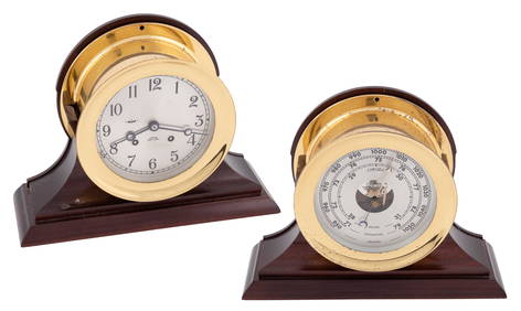
CHELSEA SHIP'S BELL CLOCK AND BAROMETER SET Boston, Massachusetts, 20th Century Bezel diametersEldred's4.7(409)See Sold PriceFeb 28, 2024
WASHINGTON, JACKSON and other HISTORICAL AMERICANAJohn McInnis Auctioneers,LLC4.6(502)See Sold PriceFeb 24, 2024
1853 Colton's Railroad & Township Map of Massachusetts, Rhode Island, and ConnecticutRail & Road Auctions4.6(165)See Sold PriceMar 07, 2024
CENTRAL AFRICA. International African Association (Congo) Gabon Angola 1889 mapJasper524.5(9.8k)See Sold PriceFeb 28, 2024
Six Piece Fletcher & Gardiner Coin Silver Tea ServiceBrunk Auctions4.6(463)See Sold PriceMar 08, 2024
Large Johnsons Anodyne Liniment Cardboard Advertising SignMatthew Bullock Auctioneers4.7(1.8k)See Sold PriceMar 02, 2024
KEYSTONE MANUFACTURING COMPANY "AIRCRAFT CARRIER".Amelia Jeffers, Auctioneers & Appraisers4.6(101)See Sold PriceMar 09, 2024
ANCIENT ADVENTURES OF TELEMACHUS, PRINTED IN BOSTON, MASSACHUSETTS, IN 1797NY Elizabeth 4.3(84)See Sold PriceMar 03, 2024
A Chinese Longquan celadon-glazed 'twin fish' dish, Song dynastyOakridge Auction Gallery4.5(190)See Sold PriceMar 15, 2024