ATLAS of ANTIENT GEOGRAPHY by SAMUEL BUTLER 1843John McInnis Auctioneers,LLC4.6(502)See Sold PriceFeb 24, 2024
18TH C. ANTIQUE MAP: FRENCH & INDIAN WAR, FRAMEDThomaston Place Auction Galleries4.4(386)See Sold PriceFeb 24, 2024
Rand McNally Railroad Map Cabinet w/ 21 Railroad MapsRail & Road Auctions4.6(165)See Sold PriceMar 08, 2024
Keith Haring - Ink on New York Map, Best Buddies, Inscribed, Signed, and DatedSapphire Auction Gallery4(67)See Sold PriceMar 02, 2024
LATE 17TH C. FRENCH MAP OF THE NEW WORLD BY ALEXIS-HUBERT JAILLOT (1632-1712)Thomaston Place Auction Galleries4.4(386)See Sold PriceFeb 24, 2024
Central Railroad of New Jersey Map of Sandy Hook Route-ca. 1903JM Hobby Supply and Railroad Artifact Auctions4.4(126)See Sold PriceFeb 24, 2024
Lot of Six Mixed Atlas Box Cars-HO Scale-New in BoxJM Hobby Supply and Railroad Artifact Auctions4.4(126)See Sold PriceFeb 25, 2024
Rand McNally/Santa Fe Railroad Map of Iowa-1912JM Hobby Supply and Railroad Artifact Auctions4.4(126)See Sold PriceFeb 24, 2024
NICOLAES VISSCHER (NETHERLANDS, 1618-1709) MAP OF THE NEW WORLDThomaston Place Auction Galleries4.4(386)See Sold PriceFeb 24, 2024
17TH C. WORLD MAP BY NICOLAES VISSCHER (NETHERLANDS, 1618-1709)Thomaston Place Auction Galleries4.4(386)See Sold PriceFeb 24, 2024
Lot of Six Mixed Atlas Cabooses-HO Scale-New in BoxJM Hobby Supply and Railroad Artifact Auctions4.4(126)See Sold PriceFeb 25, 2024
Map of Korea - HaeJa Jeondo*** START PRICE IS THE RESERVE *** [Asia] Artist Unknown (Mid-19th century). A Complete View of the Korean Peninsula Woodcut Map mounted on hanging scroll. 37 3/4" x 21 5/8". A similar map is in the cSee Sold Price
Korea – West Coast British Admiralty Chart 3699,Title/Content of Map: Korea – West Coast British Admiralty Chart 3699, published 1908 Date Printed: 1908 Cartographer: British Admiralty Material/Medium: thick paper Size: standard 71x104 cm (28x41See Sold Price
SoldJapan & Korea map in 1871_Meiji D.Japanese Antique&Old Map in 1871//Luxury version for Bureaucrat in Meiji dynasty(明治時代)//its condition is so mint.it's a rare item and valuable map for history between KoreaSee Sold Price
SoldJapanese Old Map Book / Korea / China / TaiwanJapanese Old Map Book / Korea / China / Taiwan / 45pages color maps / 21.5cm x 11.5cmSee Sold Price
SoldMAP, China & Korea, BellinChina & Korea. Jacques Nicolas Bellin, L'Empire de la Chine pour Servir a l'Histoire Generale des Voyages, from Abrege de l'Histoire Generale des Voyages, 1748 (dated). Hand Color. Attractive and detaSee Sold Price
SoldMAP, China, Korea & Japan, Bonne/LattreChina, Korea & Japan. Bonne/Lattre, L'Empire de la Chine d'Apres l'Atlas Chinois, avec les Isles du Japon, from Atlas Moderne, 1787 (circa). Hand Color. Beautifully engraved, decorative map of the ChiSee Sold Price
SoldOLD MAP OF KOREA made in Japan DATE;1903 PUBLISHER;SEISOLD MAP OF KOREA made in JapanDATE;1903PUBLISHER;SEISHIDOSIZE;18.5 X 25'See Sold Price
SoldMAP, China, Korea & Japan, Mercator/HondiusHondius' Map of China, Korea, and Japan in Full Contemporary Color. China, Korea & Japan. Mercator/Hondius, China, from Gerardi Mercatoris - Atlas sive Cosmographicae, 1613 (circa). Hand Color. BesideSee Sold Price
Sold1758 Bellin Map of Korea -- Carte de la Province deTitle: 1758 Bellin Map of Korea -- Carte de la Province de Quantong ou Lyau-Tong et du Royaume de Kau-Li ou Coree. Copiee sur la Carte Angloise. Cartographer: J Bellin Year / Place: 1758 c., Paris MapSee Sold Price
SoldMAP - China & Korea. De FerChina & Korea. Nicholas de Fer, La Chine, 1689 (published). Hand Color. Simple little map covering China and Korea. China is divided into provinces and a few major cities are shown. The title cartouchSee Sold Price
SoldETCHED KOREAN WAR STEEL MUG WITH TIGER AND MAP OF KOREAOFFERED HERE IS A ETCHED KOREAN WAR STEEL MUG WITH TIGER IN BAMBOO & MAP OF KOREA. IT IS VERY WELL DONE, 5 1/2 " TALL AND IS BEAUTIFULLY ETCHED. *See Sold Price
Sold19TH CENTURY MAP OF KOREAWoodblock printed geographical knowledge map of Korea, divided into provinces; meticulously notated with inscriptions; Provenance: with appraisal from Geographicus Rare & Antique Maps; 40" x 23 1/See Sold Price
SoldFramed antique map of Korea by J. Van Shley. HarFramed antique map of Korea by J. Van Shley. Hand-colored copper-plate engraving. Published in La Haye. Circa 1755. Map measures 11.5" tall x 9.5" wide. Was originally purchased at Jonathan Potter, LTSee Sold Price
SoldMap of KoreaArtist Unknown. c. 1800. 8 joined sheets of rice paper, black ink and blue wash. 31 3/4 x 45 1/4 inches sheet. Interesting map of Korea, marked out for administrative use. A Japanese copy of a KoreanSee Sold Price
Map of Korea[Map of Korea], chromo or color cerograph, ca. 1900s, 20.5 x 29.5 20.5 x 29.5See Sold Price
SoldMAP, China, Korea & Japan, CluverChina, Korea & Japan. Philipp Cluver, Imperii Sinarum Nova Descriptio, from Introductio in Universam Geographicam, 1697 (published). Hand Color. Handsome small map based on the important Martini/BlaeuSee Sold Price
SoldMap of Korea during Russo-Japan warHeading: (Korea & China) Author: Title: Russisch Japanischer Kriegsschaupletz. Karte II. Süd-Mandschurei, Korea, Nordost-China Place Published: Berlin Publisher:D. Reimer, Date Published: 19See Sold Price
Thomson Map of Korea and JapanThomson, John & Co. (c. 1777-1841). Corea and Japan. Engraved map. John Thomson, Junr & Co., 1817. 19 ⅜" x 24 ½" sheet. No. 37 from Thomson's New General Atlas 1817. J. & G. Menzies sculpt. ESee Sold Price
MAP, China, Korea & Japan, BellinChina, Korea & Japan. Jacques Nicolas Bellin, Carte des Isles du Japon et la Presqu Isle de Coree avec les Costes de la Chine Depuis Pekin Jusqua Canton, from Prevost's Histoire Generale des Voyages��See Sold Price
MAP, China, Korea & Japan, MercatorChina, Korea & Japan. Mercator/Jansson, China, 1630 (published). Hand Color. This handsome map of the region is based on the folio map by Jodocus Hondius and was designed for the Atlas Minor, first puSee Sold Price
Map China Korea Japan 1875 coloured PetermannCHINA KOREA UND JAPAN Beatiful map of China Korea and Japan of 1875 circa coloured by hand with aquarello painting. Author: Von A. Petermann Date: 1875 circa Technique: Copper etching Leaf Dimension:See Sold Price
MAP - China, Korea & Japan. MercatorChina, Korea & Japan. Mercator/Hondius, China, 1619 (published). Hand Color. Besides China, this map depicts Korea as an elongated island and Japan on the Ortelius-Teixeira model. The map contains rudSee Sold Price
MAP, China, Korea & Japan, JanssonChina, Korea & Japan. Jan Jansson, China Veteribus Sinarum Regio nunc Incolis Tame Dicta, 1647 (published). Hand Color. Several large lakes dominate the topography of this elegantly engraved map of ChSee Sold Price
MAP, China, Korea & Japan, De RossiChina, Korea & Japan. Cantelli da Vignola/de Rossi, Il Regno della China detto Presentemente Catay, e Mangin. Diviso Sopra le Carte piu Esatte nelle sue Principali Provincie..., 1682 (dated). Hand ColSee Sold Price
Central Railroad of New Jersey Map of Sandy Hook Route-ca. 1903JM Hobby Supply and Railroad Artifact Auctions4.4(126)See Sold PriceFeb 24, 2024
Rand McNally/Santa Fe Railroad Map of Iowa-1912JM Hobby Supply and Railroad Artifact Auctions4.4(126)See Sold PriceFeb 24, 2024
17TH C. WORLD MAP BY NICOLAES VISSCHER (NETHERLANDS, 1618-1709)Thomaston Place Auction Galleries4.4(386)See Sold PriceFeb 24, 2024
LATE 17TH C. FRENCH MAP OF THE NEW WORLD BY ALEXIS-HUBERT JAILLOT (1632-1712)Thomaston Place Auction Galleries4.4(386)See Sold PriceFeb 24, 2024
18TH C. ANTIQUE MAP: FRENCH & INDIAN WAR, FRAMEDThomaston Place Auction Galleries4.4(386)See Sold PriceFeb 24, 2024
NICOLAES VISSCHER (NETHERLANDS, 1618-1709) MAP OF THE NEW WORLDThomaston Place Auction Galleries4.4(386)See Sold PriceFeb 24, 2024
Keith Haring - Ink on New York Map, Best Buddies, Inscribed, Signed, and DatedSapphire Auction Gallery4(67)See Sold PriceMar 02, 2024
Rand McNally Railroad Map Cabinet w/ 21 Railroad MapsRail & Road Auctions4.6(165)See Sold PriceMar 08, 2024
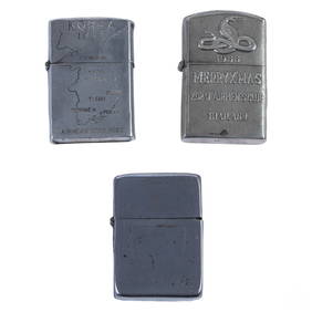
WWII Korea & Vietnam Era Silver Lighters 3pc LOTHill Auction Gallery 4.7(1k)See Sold PriceFeb 28, 2024
Putnam - First Map of the State of Ohio by Rufus PutnamTrillium Antique Prints & Rare Books4.5(30)See Sold PriceFeb 24, 2024
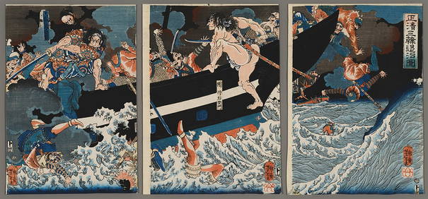
Yoshitoshi Woodblock - Masakiyo Conquers KoreaFloating World Auctions4.7(233)See Sold PriceMar 01, 2024
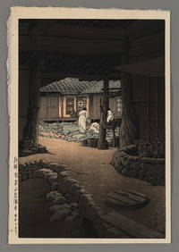
Kawase Hasui Woodblock - Modan Viewpoint, KoreaFloating World Auctions4.7(233)See Sold PriceMar 01, 2024
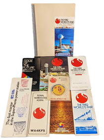
1982 Knoxville World's Fair Information And Maps LotRapid Estate Liquidators and Auction Gallery4.5(1.1k)See Sold PriceMar 02, 2024