SoldMap of Georgetown and WashingtonBeautiful map of "Georgetown and the City of Washington The Capital of the United States of America." 16-1/2"x13-3/4", hand-colored, 1855 by J. Colton and Company. Fine. Framed.See Sold Price
SoldJohnson's Washington (D.C.) & Georgetown MapPublished by A. J. Johnson, New York; "Johnson's Georgetown and The City of Washington the Capital of the United States of America."; depicting the nation's capital toward the end of or shortly afterSee Sold Price
SoldJOHNSON'S WASHINGTON AND GEORGETOWN MAPJOHNSON'S WASHINGTON AND GEORGETOWN MAP, hand-colored lithograph, dated 1868. Housed in a modern frame. Together with Johnson's Delaware and Maryland map, having Washington, DC street map inset and piSee Sold Price
Sold19th c. Map of Virginia and Maryland2 19th c. maps of US states 1). Map of Virginia and Maryland with a plan of Washington and Georgetown. 2). Map of Kentucky and Tennessee- both copper engravings, published in London in 1831 by Isaac TSee Sold Price
SoldA. PETERSON AND J. ENTHOFFER WASHINGTON, ANDA. PETERSON AND J. ENTHOFFER WASHINGTON, AND GEORGETOWN, D.C. MAP BOOK, titled "MAP OF THE CITIES OF WASHINGTON AND GEORGETOWN, D.C.", published by "A. PETERSON AND J. ENTHOFFER of the U.S. Coast SurvSee Sold Price
Americana – Signed Lt. Col. Of Engineers Peter...Americana – Signed Lt. Col. Of Engineers Peter C. Hains (1840-1921) 'Washington and Georgetown Harbours' Map – by J.E. Hilgard 1882, with proposed improvements of James Creek Canal to accompany reSee Sold Price
Americana – Lt. Col. Of Engineers Peter C...Americana – Lt. Col. Of Engineers Peter C. Hains (1840-1921) ‘Washington and Georgetown Harbours' Map – by J.E. Hilgard 1882, with proposed improvements of James Creek Canal to accompany reportSee Sold Price
Sold1855 Map of Georgetown and the City of Washington by J.H. ColtonColton's Georgetown and the city of Washington: the capital of the United States of America. Issued in 1855 by J. H. Colton (1800-1893). Hand colored. Frame size: 20 1/2" H x 24 3/4" W x 1 1/8" D. SigSee Sold Price
SoldMap of Washington DC & Georgetown, 1868Original engraving from Johnson's Atlas of the World, 1868. Map details city of Georgetown, mall & Capitol. Dimensions: 14 1/2" x 18". This item ships from Ocean View, DE.See Sold Price
1855 Colton Map of Washington DC -- Georgetown and theReserve Reduced! Title/Content of Map: 1855 Colton Map of Washington DC -- Georgetown and the City of Washington the Capital of the United States of America Date: 1855, New York Cartographer: J ColtonSee Sold Price
Sold1855 Colton Map of Washington DC -- Georgetown and theTitle/Content of Map: 1855 Colton Map of Washington DC -- Georgetown and the City of Washington the Capital of the United States of America Date: 1855, New York Cartographer: J Colton Size: 11.8 X 14.See Sold Price
1855 Colton Map of Washington DC -- Georgetown and theReserve Reduced! Title/Content of Map: 1855 Colton Map of Washington DC -- Georgetown and the City of Washington the Capital of the United States of America Date: 1855, New York Cartographer: J ColtonSee Sold Price
Sold1874 MAP OF WASHINGTON, DC1874 MAP OF WASHINGTON, DC A nicely illustrated and hand tinted 1874 map, entitled: "Georgetown and the City of Washington. The Capitol of the United States", 16 1/2" x 14", published by C. B. ColtonSee Sold Price
SoldJ. Colton & Co, Georgetown & Washington. 1855.A J. Colton & Co. map of Georgetown and the city of Washington. 3 corners are decorated with vignettes of the Smithsonian Institution, the US Capitol & the plan for the Washington monument. c.1855, haSee Sold Price
Sold1862 Johnson Map of Washington DC -- Johnson'sTitle: 1862 Johnson Map of Washington DC -- Johnson's Georgetown and the City of Washington the Capital of the United States of America Date: 1862, New York Cartographer: Johnson and Browning Size: 12See Sold Price
SoldEngraved Map of Washington DC for the B and O RailroadEngraved Map of Washington DC for the B and O Railroad Guide to Washington, Georgetown Estimate: $50See Sold Price
Map of the Cities of Washington and Georgetown, D.C.Title: Map of the Cities of Washington and Georgetown, D.C. Published by W.H. & O.H. Morrison 1876 [Copy] Publication Date: 1877 Cartographer: MORRISON, W.H./O.H. MORRISON Publisher: U.S. SENATE Size:See Sold Price
Soldc. 1863 MAP Johnson's GEORGETOWNMapsc. 1863, JOHNSON’S GEORGETOWN AND THE CITY OF WASHINGTON...,” By Johnson and Ward, Choice Very Fine. 13.75” x 16.5,” hand-colored, lithographed map with ornate border. VignSee Sold Price
Soldc. 1863 MAP Johnson's GEORGETOWNc. 1863, JOHNSON'S GEORGETOWN AND THE CITY OF WASHINGTON...," By Johnson and Ward, Choice Very Fine. 13.75" x 16.5," hand-colored, lithographed map with ornate border. Vignettes of Washington sites prSee Sold Price
SoldUNITED STATES MAPS, LOT OF THREEUNITED STATES MAPS, LOT OF THREE, comprising "Map of the Stated of Virginia and Maryland" with inset "Plan of Washington and Georgetown", engraved and published by Fenner, Sears & Co., circa 1831; andSee Sold Price
Sold1831 Original Engraved Map of Virginia and MDAn original copper engraved hand-colored map of the states of Virginia and Maryland with a plan of Washington and Georgetown. This piece was published in London in 1831 by Isaac Taylor Hinton and SimpSee Sold Price
Map of the States of Virginia and Maryland 1831Title: Map of the States of Virginia and Maryland Author: Hinton, John Howard Description: Copper-engraved map. 27x41 cm. (10½x16").With inset plan of Washington and Georgetown. From the atlas to accSee Sold Price
SoldMap of the States of Virginia and Maryland 1831Title: Map of the States of Virginia and Maryland Author: Hinton, John Howard Description: Copper-engraved map. 27x41 cm. (10½x16").With inset plan of Washington and Georgetown. From the atlas to accSee Sold Price
Northern Pacific RR Washington and Northern Idaho Map Folder-1941JM Hobby Supply and Railroad Artifact Auctions4.4(127)See Sold PriceFeb 24, 2024
Rand McNally Railroad Map of Washington-1906JM Hobby Supply and Railroad Artifact Auctions4.4(127)See Sold PriceFeb 24, 2024
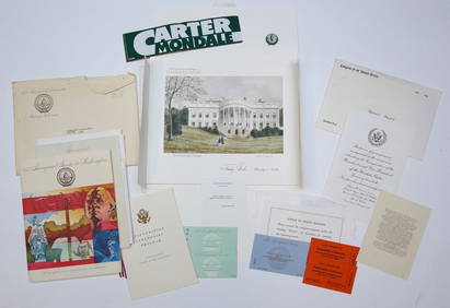
1977 INAUGURATION of PRESIDENT JIMMY CARTERJohn McInnis Auctioneers,LLC4.5(505)See Sold PriceFeb 25, 2024
"THE MEANING OF SAINTHOOD" SERMON & ARRANGMENTSJohn McInnis Auctioneers,LLC4.5(505)See Sold PriceFeb 25, 2024
Mitchell - Map of the City of Washington (Washington, DC)Trillium Antique Prints & Rare Books4.5(32)See Sold PriceFeb 24, 2024
Goode, George Brown 1884 Lot of 4 Natural History & Meteorology MapsAlbion Auctions4.7(341)See Sold PriceMar 01, 2024
Perry, Matthew C. 1856 Large Map. Shah Bay, Lew Chew I. JapanAlbion Auctions4.7(341)See Sold PriceMar 01, 2024
Francis McNally - Antique Map of Washington, Oregon, Idaho, Nevada, Utah & ArizonaProverde Auctions4.3(3)See Sold PriceFeb 28, 2024
[Spokane, Washington State] Maps, Pins & More (8)Grant Zahajko Auctions, LLC4.7(1k)See Sold PriceMar 06, 2024


![[Spokane, Washington State] Maps, Pins & More (8) (1 of 5)](https://p1.liveauctioneers.com/5755/320282/172114031_1_x.jpg?height=282&quality=70&version=1708463029)

