Marc Chagall-Limited Edition -Paris Opera Ceiling after ChagallArt Legacy Auctions4.5(217)See Sold PriceFeb 24, 2024
Salvador Dali Pantagruel Limited Edition Lithograph Hand signed and numberedArt Legacy Auctions4.5(217)See Sold PriceFeb 24, 2024
Pablo Picasso Bouquet of Peace Collection Domaine Picasso Limited Edition on paper.Art Legacy Auctions4.5(217)See Sold PriceFeb 24, 2024
A RARE MAXFIELD PARRISH JACK AND THE BEANSTALK PRINTSoulis Auctions4.8(953)See Sold PriceFeb 24, 2024
LARGE MECHANICAL PRINT 'STARS' AFTER MAXFIELD PARRISHSoulis Auctions4.8(953)See Sold PriceFeb 24, 2024
Heinrich Aldegrever, etc. 15 old master prints. 16th-17th centuries. Aldegrever works include "ManTremont Auctions4.6(293)See Sold PriceFeb 25, 2024
Map of French Empire. Europe. 1871.Map of French Empire divided into 130 departments. Europe. 1871.Print from steel engraving titled „Empire Francais divise en 130 departements“.Author/compiler - MM. Drioux et Ch. Leroy.Engraver unSee Sold Price
Map of French Empire in 1813. Europe. 1854.Print of hand colored steel engraving titled „Carte de L’ Empire Francais en 1813”.Drawn by L. Dussieux. Engraved by Marlier.From „Atlas General De Geographie physique, politique et historiqueSee Sold Price
Algeria. Africa. 1871.Physical and political map of The French colonies in Algeria. Europe/Africa. 1871.Print from steel engraving titled „Carte physique et politique de L‘ Algerie colonies Francaises“.Author/compileSee Sold Price
NAPOLEONIC EMPIRE. The French Empire in 1810. Europe 1902 old antique mapTITLE/CONTENT OF MAP: 'The French Empire in 1810' DATE PRINTED: 1902 IMAGE SIZE: Approx 25.0 x 32.5cm, 9.75 x 12.75 inches (Large) TYPE: Antique colour map. This map was published in 1902 but it may dSee Sold Price
NAPOLEONIC EMPIRE. The French Empire in 1810. Europe 1902 old antique mapTITLE/CONTENT OF MAP: 'The French Empire in 1810' DATE PRINTED: 1902 IMAGE SIZE: Approx 25.0 x 32.5cm, 9.75 x 12.75 inches (Large) TYPE: Antique colour map. This map was published in 1902 but it may dSee Sold Price
SoldMID-LATE 20TH CENTURY PRINTED MAP OF EUROPE AMID-LATE 20TH CENTURY PRINTED MAP OF EUROPE AND THE FRENCH EMPIRE IN 1807. Printed in France 19" x 14" *Condition: Good *Est. Sale Time: 2:57 PM Eastern *Kamelot handles shipping arrangements for thosSee Sold Price
Europe exhibiting its principal states &c. First French Empire. FADEN 1791 mapTITLE/CONTENT OF MAP: 'Europe exhibiting its principal states &c' DATE PRINTED: 1791 IMAGE SIZE: Approx 54.5 x 69.5cm, 21.5 x 27.25 inches (Large); Please note that this is a folding map. TYPE: LargeSee Sold Price
Europe exhibiting its principal states &c. First French Empire. FADEN 1791 mapTITLE/CONTENT OF MAP: Turquie d’Europe [Turkey in Europe] DATE PRINTED: 1788 IMAGE SIZE: Approx 24.5 x 36.0cm, 9.5 x 14.25 inches (Large); Please note that this is a folding map. TYPE: Antique 1See Sold Price
SoldTwo French Maps and Augustus MitchellAugustus Mitchell 1867 Map of The Austrian Empire Italian States. Turkey in Europe and Greece, Also This hand colored celestial map of the Stars and Constellations is a steel plate engraving, dating tSee Sold Price
SoldA French Map of Paris.A French Map of Paris. 19th century restrike of a 1576 map of Paris published by Rossingol. Together with a later strike of the 19th century map 'Carte Politique de l'Europe et de l'Empire Francais' (See Sold Price
Europe 1878'. Ottoman & Austrian Empires. BARTHOLOMEW 1876 old antique mapCAPTION PRINTED BELOW PICTURE: 'Europe 1871' DATE PRINTED: 1876 IMAGE SIZE: Approx 15.5 x 22.5cm, 6 x 8.75 inches (Medium) TYPE: Antique colour map CONDITION: Good; suitable for framing. However, pleaSee Sold Price
SoldFrench Lithographic Map of 1807 EuropeFrench lithographic map of 1807 Europe, coat of arms and title to the upper left corner reads in French ‘Carte politburo et itineraire de L’Europe et du L’Empire Francais en 1807’, legend to lSee Sold Price
SoldFaden (William) - The French Empire and the Kingdom ofshowing most of Europe, large table of French departments to the left, inset table of Italian departments upper right, engraved map with original hand-colouring, 565 x 905mm., dissected and linen-backSee Sold Price
SoldAlexis Hubert Jaillot "Estats de l'empire" engravingALEXIS HUBERT JAILLOT (French 1632-1712) "Estats de L'Empire des Turqs en Europe, subdivises suivant l'Estendue des Beglerbeglicz our Gouvernements...1700" Copperplate engraving with hand colored outlSee Sold Price
SoldFrench Political Cartoon Map, "L'Europe en 1871"French political cartoon, a whimsical map of Europe depicting the nations as caricatured figures, 1871; lithograph with color. Sheet: 17.25" H X 21" W; frame: 18.5" X 22.25".See Sold Price
SoldMap of Empire of Charlemagne. Europe. 1854.Print of hand colored steel engraving titled „Carte du Partage de L’Empire de Charlemagne“.Drawn by L. Dussieux.Engraved by unknown.From „Atlas General De Geographie physique, politique et hisSee Sold Price
Empire of Charlemagne. Europe. 1854.Print of hand colored steel engraving titled „Empire de Charlemagne“.Drawn by L. Dussieux.Engraved by unknown.From „Atlas General De Geographie physique, politique et historique par L. Dussieux.See Sold Price
SoldRobert de Vaugondy (French, 1723-1786)Robert de Vaugondy (French, 1723-1786), "Carte Generale de l'Empire des Russes en Europe et en Asie...", 1753, engraved map on two sheets (not joined), hand-colored in outline, with elaborate cartouchSee Sold Price
SoldRobert de Vaugondy (French, 1723-1786)Robert de Vaugondy (French, 1723-1786), "Carte Generale de l'Empire des Russes en Europe et en Asie...", 1753, engraved map on two sheets (not joined), hand-colored in outline, with elaborate cartouchSee Sold Price
SoldRobert de Vaugondy (French, 1723-1786)Robert de Vaugondy (French, 1723-1786), "Carte Generale de l'Empire des Russes en Europe et en Asie...", 1753, engraved map on two sheets (not joined), hand-colored in outline, with elaborate cartouchSee Sold Price
SoldRobert de Vaugondy (French, 1723-1786)Robert de Vaugondy (French, 1723-1786), "Carte Generale de l'Empire des Russes en Europe et en Asie...", 1753, engraved map on two sheets (not joined), hand-colored in outline, with elaborate cartouchSee Sold Price
SoldJansson. Imperium Carolimagni map[Carolinian Empire]. Jansson. Imperium Carolimagni. Double-page engraved map of Europe at the time of Charlemagne. French text on verso. Amst: Ioannis Ianssonii, mid-17th century. 14 1/2 x 17 in. PublSee Sold Price
Map of French Empire. Print in 1850.Map of French Empire United with Italy in 1809. Print in 1850.Print of steel engraving titled „Empire Francais en Royaume lItalie en 1809.Author A. Houze.Engraved by unknown.From the „Atlas UniverSee Sold Price
Physical map of Europe. 1871.Print from steel engraving titled „Carte physique de L‘ Europe“.Author/compiler - MM. Drioux et Ch. Leroy.Engraved by Jenotte.Notes: 44.From „Atlas universel et classique de geographie anciennSee Sold Price
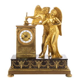
FRENCH EMPIRE GILTWOOD BAROMETER BY BINDA, PARISThomaston Place Auction Galleries4.4(386)See Sold PriceFeb 24, 2024
18TH C. ANTIQUE MAP: FRENCH & INDIAN WAR, FRAMEDThomaston Place Auction Galleries4.4(386)See Sold PriceFeb 24, 2024
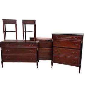
Six (6) pc RWAY French Empire Style Bedroom SetPremier Auction Galleries4.3(329)See Sold PriceMar 09, 2024
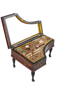
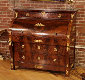
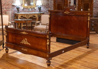
(19th c) FRENCH EMPIRE PIANO-FORM NECESSAIREJohn McInnis Auctioneers,LLC4.6(502)See Sold PriceFeb 25, 2024
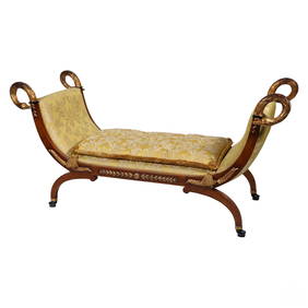
French Empire Style Carved Swan Recamier DaybedHill Auction Gallery 4.7(1k)See Sold PriceFeb 28, 2024
1816 MAP SOUTHERN PART OF RUSSIA or MUSCOVY in EUROPE copper engraving ANTIQUEJasper524.5(9.8k)See Sold PriceFeb 27, 2024
1816 MAP NORTHERN PART OF RUSSIA or MUSCOVY in EUROPE copper engraving ANTIQUEJasper524.5(9.8k)See Sold PriceFeb 27, 2024
New and Correct Map of North America With the West India Islands,Jasper524.5(9.8k)See Sold PriceFeb 27, 2024
Clarke & Neele 1815 Map. Europe - Recent Political ChangesAlbion Auctions4.6(336)See Sold PriceMar 01, 2024
PROUST MARCEL: (1871-1922)International Autograph Auctions Europe S.L.4.5(52)See Sold PriceMar 14, 2024
PROUST MARCEL: (1871-1922)International Autograph Auctions Europe S.L.4.5(52)See Sold PriceMar 14, 2024
TURGENEV IVAN: (1818-1883) 'I will come to revive the memories of "auld lang syne"'International Autograph Auctions Europe S.L.4.5(52)See Sold PriceMar 14, 2024
MARIE LOUISE DUCHESS OF PARMA: (1791-1847)International Autograph Auctions Europe S.L.4.5(52)See Sold PriceMar 14, 2024