ATLAS of ANTIENT GEOGRAPHY by SAMUEL BUTLER 1843John McInnis Auctioneers,LLC4.6(502)See Sold PriceFeb 24, 2024
18TH C. ANTIQUE MAP: FRENCH & INDIAN WAR, FRAMEDThomaston Place Auction Galleries4.4(386)See Sold PriceFeb 24, 2024
Rand McNally Railroad Map Cabinet w/ 21 Railroad MapsRail & Road Auctions4.6(165)See Sold PriceMar 08, 2024
Keith Haring - Ink on New York Map, Best Buddies, Inscribed, Signed, and DatedSapphire Auction Gallery4(67)See Sold PriceMar 02, 2024
LATE 17TH C. FRENCH MAP OF THE NEW WORLD BY ALEXIS-HUBERT JAILLOT (1632-1712)Thomaston Place Auction Galleries4.4(386)See Sold PriceFeb 24, 2024
Central Railroad of New Jersey Map of Sandy Hook Route-ca. 1903JM Hobby Supply and Railroad Artifact Auctions4.4(126)See Sold PriceFeb 24, 2024
Lot of Six Mixed Atlas Box Cars-HO Scale-New in BoxJM Hobby Supply and Railroad Artifact Auctions4.4(126)See Sold PriceFeb 25, 2024
Rand McNally/Santa Fe Railroad Map of Iowa-1912JM Hobby Supply and Railroad Artifact Auctions4.4(126)See Sold PriceFeb 24, 2024
NICOLAES VISSCHER (NETHERLANDS, 1618-1709) MAP OF THE NEW WORLDThomaston Place Auction Galleries4.4(386)See Sold PriceFeb 24, 2024
17TH C. WORLD MAP BY NICOLAES VISSCHER (NETHERLANDS, 1618-1709)Thomaston Place Auction Galleries4.4(386)See Sold PriceFeb 24, 2024
Lot of Six Mixed Atlas Cabooses-HO Scale-New in BoxJM Hobby Supply and Railroad Artifact Auctions4.4(126)See Sold PriceFeb 25, 2024
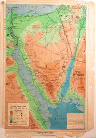
Map of Eretz Israel - engraving - Amsterdam, c - 1700CARTE DE LA TERRE SAINTE - Map of the Land of Israel from the Atlas Pierre Mortier, Amsterdam around 1700. Size: 35x29 cm, framed in wood and glass 52x45 cm. Tears to margins and middle,moderate condiSee Sold Price
SoldMap of Eretz Israel - Engraving - Amsterdam, 1629Terra Sancta quae in sacris Terra Promissionis olim Palestina. Map of Eretz Israel. Engraving colored by hand, out of the first atlas by Willem Janszoon Blaeu. Amsterdam, 1629. Map of Eretz Israel, SiSee Sold Price
Map of Eretz Israel - Engraving - Amsterdam, 1707Tabula Geographica Terrae Sanctae. Map of Eretz Israel. Franciscus Halma publishing, Amsterdam [1707]. Large map of Eretz Israel, divided according to the living areas of the Twelve Tribes. From the bSee Sold Price
SoldMap of Eretz Israel - From the Amsterdam Haggadah, 1712"…Fourty years in the desert through the Holy Land…", by Avraham Ben Ya'akov Hagar. Copper engraving. [Amsterdam], 1712. Eretz Israel, divided among the tribes, on both sides of the JordanSee Sold Price
SoldMortier Map of Chesapeake BayCarte Particuliere de Virginie, Maryland, Pennsilvanie, La Nouvelle Jarsey. Orient et Occidentale. Pierre Mortier (1661–1711). Engraving with original handcolor. Amsterdam, c. 1700. 21 1/2 x 32 inchSee Sold Price
Early Engraved and Colored Map of IsraelEarly Engraved and Colored Map of Israel. Twelve Tribes of Israel during Biblical times. Showing present day Israel, Jordan and Lebanon. Published by: Covens, I./Mortimer, C., Amsterdam 1700. 16 1/2"See Sold Price
SoldEarly map of Mid-Atlantic states, by A.H. JaillotEarly map of Mid-Atlantic states, by A.H. Jaillot (1632-1712), engraved by an unidentified engraver and published by Pierre Mortier, Amsterdam, c. 1700, an engraving in black and white, 22" x 33" sighSee Sold Price
SoldAllard Map of AmericaALLARD, Carol (1648 - 1709).Recentissima Novi Orbis Sive Americae Septentrionale et Meridionalis.From Atlas MinorCopperplate engraving with original hand color.Amsterdam: c. 1700 (State 3).20 1/2" x 2See Sold Price
Van Keulen Map of Northwest PassagePascaarte vande Noorder Zeekulten van America. Gerard Van Keulen (1654-1715). Engraving with hand color in outline. Amsterdam, c. 1700. 17 3/4 x 22 1/2 inches. An impressive sea chart showing the areaSee Sold Price
SoldTitle Page of Covens & Mortier Atlas MinorTitle Page of Atlas Minor ad Usum Serenissimi... Romeyn De Hooghe (1645-1708). Hand-colored engraving heightened in gold. Amsterdam: Covens & Mortier, c. 1700. 21 1/4 x 13 inches sheet, 24 x 16 inchesSee Sold Price
SoldSchenk Map of RussiaSCHENK, Petrus (1660-1711). La Russie Blanche Moscovie... Engraved map with original color. Amsterdam, c. 1700. 21 1/8" x 25" sheet. Handsome map showing the extent of the Russian Empire in Europe. ThSee Sold Price
SoldMortier Map of Southeast AsiaMORTIER, Pierre (1661-1711). Le Royaume de Siam Avec les Royaumes qui luy sont Tributaires... Engraved Map with original hand color. Amsterdam, c. 1700. 32 1/4" x 23 1/2" sheet. This finely detailed aSee Sold Price
Allard Map Novi OrbisRecentissuma Novi Orbis Sive Americae Septentrionale et Meridionalis. Carl Allard (1648 - 1709). Engraved Map with Original Hand-color in part. Amsterdam: c. 1700, state 3. Burden 724. 21 x 24 1/4 incSee Sold Price
SoldMortier Map of Valletta, MaltaValetta civitas nova. Maltae olim Millitae. Pierre Mortier (1661–1711). Engraved Map. Amsterdam, c. 1700. 17 3/4 x 22 inches sheet. A dynamic bird’s-eye view of Valletta, the capital city of MaltaSee Sold Price
SoldMiddle East Antique Dutch MapNicolaes Visscher (1618-1679). De Gelegentheyt Van't Paradys Ende 'T Landt Canaan. Amsterdam, c. 1650. Hand-colored engraving. Holy Land, Israel, Palestine. 16 1/2" x 20 1/2".See Sold Price
Ancona/ Ville de l'Etat de l'EglisePierre Mortier (1661-1711). Engraved map with original hand-color. Amsterdam: Blaeu, c. 1700. 21 1/2 x 25 inches visible, 32 1/2 x 35 3/4 inches framed. Beautifully Colored 18th century Map of criticaSee Sold Price
SoldMortier Map of East Coast 1700MORTIER, Pierre (1661-1711). Carte Particuliere de Virginie, Maryland, Pennsilvanie, La Nouvelle Jarsey... Engraved map with original hand color in outline. Amsterdam and Paris, c. 1700. 24 3/4” x 3See Sold Price
SoldPlanisphaerium Terrestre cum utroque CoelestiPlanisphaerium Terrestre cum utroque Coelesti hemisphaerio... Repraesentio. Amsterdam: P. Schenk, c. 1700. 20 x 22 4/8 inches. An attractive and interesting map full of detail including the routes & dSee Sold Price
SoldFrance Antique Map & View, 17th C.Descriptio Veromanduorum, Antique map, Blaeu, Amsterdam, mid 17th C. W/ view Mommedy on 2 separate sheets, engraving by Israel Silvestre, 1669. 19 1/2" x 26 1/4".See Sold Price
Map of the Holy Land According to Tribal Divisions -Terra Sancta Sive Promissionis Olim Palestina - engraving depicting the Land of Israel according to tribal divisions, hand-painted at the time of printing by I. Covens and C. Mortier, Amsterdam 17th -See Sold Price
SoldMap of Eretz Israel - Engraving Colored by Hand -Palestinae delineatio ad geographiae canones revocata, map of Eretz Israel by Philippe Briet. Copper engraving, colored by hand. Paris: Pierre Mariette publishing, [1641]. Map of Eretz Israel, dividedSee Sold Price
SoldMap of Eretz Israel – Amsterdam, 1792Generaale Kaart van het Beloofde Land tot verlichting voor de Geschiedenisse Berat in den Bybel [map of the Promised Land for a historic maps book]. Elwe Jan Barend, Amsterdam 1792. Copper print, partSee Sold Price
Map of Eretz Israel – Engraving by Abraham Ortelius, 15Palestinae sive totius Terrae Promissionis nova descriptio avctore Tilemanno Stella Sigenens Map of Eretz Israel – Engraving by cartographer Abraham Ortelius. Printed by Christopher Plantin, AntwerpSee Sold Price
c. 1700 Israel Engraved Hand-Colored + Framed MapHistoric Maps c. 1700 Framed Engraved Hand-Colored Map of Israel c. 1700, Engraved Hand-Colored Map of Israel titled, "Heylige Land verdeeld in de Traalf Stammen Israels Waar in duudelek is aan geneesSee Sold Price
M. de BOILEAU Satires & Works First 1st 1737 Edition Amsterdam Printing FrenchLuis Porretta Fine Arts4.3(10)See Sold PriceMar 02, 2024
PETRUS LANGENDULT New Testament Commentary c1687 Full Calf Dutch AmsterdamLuis Porretta Fine Arts4.3(10)See Sold PriceMar 02, 2024
OFFER VAN ABRAHAM Book Of Genesis in Engravings c1700 Amsterdam Very rare!Luis Porretta Fine Arts4.3(10)See Sold PriceMar 02, 2024
MARTINET / DE VRIES Catechism of Nature 4 Vol. Set c1788 Engravings Rare!Luis Porretta Fine Arts4.3(10)See Sold PriceMar 02, 2024
CHARLES KINGSLEY ILLUSTRATIONS BY H.C.SELOUS OF HEREWARD THE WAKE (ART UNION OF LONDON)Luis Porretta Fine Arts4.3(10)See Sold PriceMar 02, 2024
JAN VAN DER DESYATER c1732 First Edition Thoughts On Sleepless Nights Rare!Luis Porretta Fine Arts4.3(10)See Sold PriceMar 02, 2024
LARGE LATE 17TH C. DUTCH CHART OF CANADA, GREAT LAKES, NEW FRANCE, LABRADOR, HUDSON BAY, BY PIERREThomaston Place Auction Galleries4.4(386)See Sold PriceFeb 24, 2024
17TH C. WORLD MAP BY NICOLAES VISSCHER (NETHERLANDS, 1618-1709)Thomaston Place Auction Galleries4.4(386)See Sold PriceFeb 24, 2024
EARLY 18TH C. DUTCH CHART OF PACIFIC OCEAN BY FREDERIK DE WIT (1629-1706) WITH CALIFORNIA AS ANThomaston Place Auction Galleries4.4(386)See Sold PriceFeb 24, 2024
EARLY 18TH C. MAP OF ITALY, FRAMEDThomaston Place Auction Galleries4.4(386)See Sold PriceFeb 24, 2024
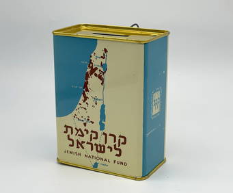
Jewish National Fund Collection Box - Great BritainLevy Auction House4.3(11)See Sold PriceFeb 27, 2024
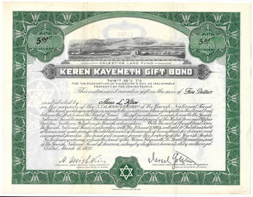
Eretz Israel Map Postcard - World Zionist OrganizationLevy Auction House4.3(11)See Sold PriceFeb 27, 2024
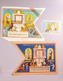
Illustrated Sabbath Cloth - Holy Sites of Eretz IsraelLevy Auction House4.3(11)See Sold PriceFeb 27, 2024
Johann Homann Hand-Colored Map Engraving, c. 1730Auctions at Showplace4.5(726)See Sold PriceMar 17, 2024