MATTHEWS c1856 Map Of Upper Canada Ontario Indian Land Agency Divisions Scarce!Luis Porretta Fine Arts4.3(10)See Sold PriceMar 02, 2024
DEVINE c1856 Dr Salters Map Of Lake Huron Ontario Indian Lands etc. No. 7 ScarceLuis Porretta Fine Arts4.3(10)See Sold PriceMar 02, 2024
DUNLEVIE c1856 Map Counties Of Gaspe & Bonaventure Quebec Canada SCARCE! #1Luis Porretta Fine Arts4.3(10)See Sold PriceMar 02, 2024
DUNLEVIE c1856 Map Counties Of Gaspe & Bonaventure Quebec Canada SCARCE! #2Luis Porretta Fine Arts4.3(10)See Sold PriceMar 02, 2024
Map UNITED COUNTIES LEEDS & GRENVILLE by Walling 1861 Rare Canada Map 5ft x 5ftLuis Porretta Fine Arts4.3(10)See Sold PriceMar 02, 2024
Ambroise TARDIEU c1822 Map Venice Napoleon Italian Campaign 17" x 11"Luis Porretta Fine Arts4.3(10)See Sold PriceMar 02, 2024
SoldMap of Detroit and Vicinity, 1898Map: Detroit and Vicinity Rand, McNally & Co. 1898 New Standard Atlas of the World Size: 28 x 21.5 inches No Reserve: This lot starts at $1 and has no reserve as a courtesy so that collectors can deteSee Sold Price
Military map of Habana and vicinity, 1898Title: Military map of Habana and vicinity, 1898 Publication Date: 1898 Cartographer: Charles H. Ourand Publisher: War Department, Adjutant-General's Office, Description: Large map from "Military noteSee Sold Price
SoldRand-McNally Map of Brooklyn & Vicinity (118297)22" X 28" in plastic poster frame. Provenance: Country (if not USA): State: New York City/County: Brooklyn Date: 1898See Sold Price
SoldCollection of Antique Maps of American CitiesNew Orleans, Milwaukee, Cincinnati, Pittsburg and Allegheny, Washington DC, Philadelphia, Detroit, Chicago, Manhattan, and Greater New York and Vicinity. Published by The Americana Company, 1904-1906.See Sold Price
SoldOhio Railway Map 1898, (4) Baedeker's HandbooksFolding linen-backed "Railroad Map of Ohio, Published By The State" (1898 Columbus Litho Co.) prepared under the direction of R S Kayler, Commissioner of Railroads and Telegraphs. showing 42 RailroadsSee Sold Price
SoldMexico Cuba & Central America Colored Map 1898This colorful map came from Cram's 1898 Universal Atlas - Geographical, Astronomical and Historical. In 1869 the George F. Cram Company was born and the Cram name quickly became synonymous with accuraSee Sold Price
SoldEarly Color Litho of Detroit 1898 WaterfrontEarly Color Litho of Detroit 1898 Waterfront in original gesso frame. Tear at 12:00, mat has age darkening. 51 1/4 X 13 1/4 inches overall.See Sold Price
SoldEARLY HAND COLORED MAP "DETROIT DE MAGELLAN", 1780,"Detroit De Magellan avec les Plans des principaux Ports, Bayes, &c. de ce Detroit". Published by Rogobert Bonne, 1780, Paris marked in top margin "Voyages des Capits. Byron, Vallis et Carteret" DetaiSee Sold Price
SoldMexico Cuba & Central America Colored Map 1898This colorful map came from Cram's 1898 Universal Atlas - Geographical, Astronomical and Historical. In 1869 the George F. Cram Company was born and the Cram name quickly became synonymous with accuraSee Sold Price
Mexico Cuba & Central America Colored Map 1898This colorful map came from Cram's 1898 Universal Atlas - Geographical, Astronomical and Historical. In 1869 the George F. Cram Company was born and the Cram name quickly became synonymous with accuraSee Sold Price
Mexico Cuba & Central America Colored Map 1898This colorful map came from Cram's 1898 Universal Atlas - Geographical, Astronomical and Historical. In 1869 the George F. Cram Company was born and the Cram name quickly became synonymous with accuraSee Sold Price
Mexico Cuba & Central America Colored Map 1898This colorful map came from Cram's 1898 Universal Atlas - Geographical, Astronomical and Historical. In 1869 the George F. Cram Company was born and the Cram name quickly became synonymous with accuraSee Sold Price
SoldDenver and Vicinity 1898Title: Portrait and Biographical Record of Denver and Vicinity Colorado. Containing Portraits and Biographies of many well known Citizens of the Past and Present. Together with Biographies and PortraiSee Sold Price
SoldThe Boston at Hawaii w/folding map 1898Title: The Boston at Hawaii: or the Observations and Impressions of a Naval Officer During a Stay of Fourteen Months in Those Islands on a Man-of-War Author: Young, Lucien Description: xi, 311 pp. FroSee Sold Price
SoldGeorge Cram's Unrivaled Montana Atlas Map 1898For your consideration is a 1898 copy of George Cram's Unrivaled atlas map of the world, Montana map. George F. Cram (1842-1928), or George Franklin Cram, was an American mapmaker and businessman. InSee Sold Price
Mexico Cuba & Central America Colored Map 1898This colorful map came from Cram's 1898 Universal Atlas - Geographical, Astronomical and Historical. In 1869 the George F. Cram Company was born and the Cram name quickly became synonymous with accuraSee Sold Price
Mexico Cuba & Central America Colored Map 1898This colorful map came from Cram's 1898 Universal Atlas - Geographical, Astronomical and Historical. In 1869 the George F. Cram Company was born and the Cram name quickly became synonymous with accuraSee Sold Price
SoldGuide to Yukon gold fields with large map 1898Heading: Author: Ogilvie, William Title: Guide Officiel du Klondike Le Grand Champ D'Or du Canada le District du Yukon Place Published: Toronto Publisher:The Hunter, Rose Co., Limited Date PubliSee Sold Price
SoldThe Boston at Hawaii w/folding map 1898Heading: Author: Young, Lucien Title: The Boston at Hawaii: or the Observations and Impressions of a Naval Officer During a Stay of Fourteen Months in Those Islands on a Man-of-War Place Published: WSee Sold Price
Mexico Cuba & Central America Colored Map 1898This colorful map came from Cram's 1898 Universal Atlas - Geographical, Astronomical and Historical. In 1869 the George F. Cram Company was born and the Cram name quickly became synonymous with accuraSee Sold Price
Mexico Cuba & Central America Colored Map 1898This colorful map came from Cram's 1898 Universal Atlas - Geographical, Astronomical and Historical. In 1869 the George F. Cram Company was born and the Cram name quickly became synonymous with accuraSee Sold Price
Sold1898 Rand McNally Chart of World Flags -- [World Flags]Title/Content of Map: 1898 Rand McNally Chart of World Flags -- [World Flags] Cartographer: Rand McNally Year/Place: 1898, Chicago Size: 12.5 X 9.2 in. This is a very nice chart of 60 world flags, orgSee Sold Price
SoldRand McNally Map India, Burma, Nepal and Ceylon, 1898Map: 1898 Rand McNally India, Burma, Nepal and Ceylon -- India Cartographer: Rand McNally Year / Place: 1898, Chicago Map Dimension: 26.2 X 19.2 in. A very nice map of South East Asia. Highly detailedSee Sold Price
Crams Township and Railroad Map of Pennsylvania-1898JM Hobby Supply and Railroad Artifact Auctions4.4(126)See Sold PriceFeb 24, 2024
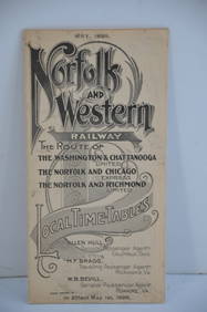
Norfolk and Western RY May 1898 Public TimetableJM Hobby Supply and Railroad Artifact Auctions4.4(126)See Sold PriceFeb 24, 2024
Assortment of Railroad Paper - Rule Books, Stationary, Ink Blotter, Map, Timetables, and MoreRail & Road Auctions4.6(165)See Sold PriceMar 07, 2024
NORTH & COLONIAL WEST AFRICA. Nigeria marked as "Royal Niger Company" 1898 mapJasper524.5(9.8k)See Sold PriceFeb 28, 2024
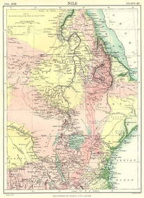
NILE VALLEY. Sudan Tanzania Ethiopia Uganda Lake Victoria. Britannica. 1898 mapJasper524.5(9.8k)See Sold PriceFeb 28, 2024
Algeria Morocco & Tunis. North Africa. Tunisia. Maghreb. BARTHOLOMEW 1898 mapJasper524.5(9.8k)See Sold PriceFeb 28, 2024
COLONIAL CENTRAL AFRICA. Congo German East Africa Rhodesia. BARTHOLOMEW 1898 mapJasper524.5(9.8k)See Sold PriceFeb 28, 2024
AFRICA. Africa. Britannica 9th edition 1898 old antique vintage map plan chartJasper524.5(9.8k)See Sold PriceFeb 28, 2024
AFRICA French Congo State Soudan Nile Delta Suez canal by GW BACON 1898 mapJasper524.5(9.8k)See Sold PriceFeb 28, 2024
Two Hand-Colored 19th Century Maps of New Orleans and Louisiana, Larger- H.- 12 1/2 in., W.- 15 1/2Crescent City Auction Gallery4.3(231)See Sold PriceMar 08, 2024
Jules Verne, L'Archipel en Feu, Au Steamer Red MacaronLion and Unicorn4.8(1.9k)See Sold PriceMar 10, 2024


![1898 Rand McNally Chart of World Flags -- [World Flags] (1 of 1)](https://p1.liveauctioneers.com/5584/173638/87405912_1_x.jpg?height=282&quality=70&version=1594766493)