SoldMap of Denbighshire, John Speede, 17th C.Map of Denbighshire, John Speede, 17th Century, handcolored, 16" x 21 1/2". Old restoration on left side.See Sold Price
Sold1610 John Speede Engraved Antique Map Of Surrey17th C John Speede Map Of Surrey. Surrey Described And Divided Into Hundreds' By John Speed Dated 1610. Includes View Of Richmont And Nonsuch Castles. London And The Thames Are Visible In The Upper PaSee Sold Price
Sold17THC MAP OF HEREFORDSHIRE, JOHN SPEEDE17THC MAP OF HEREFORDSHIRE, JOHN SPEEDE, PENCIL DATED 1621 LOWER RIGHT, 21 1/2" X 26", TEARS AT EDGES, WATER MARK LOWER EDGE, TEARS AT VERTICAL CENTER CREASE, UNFRAMED.See Sold Price
SoldMap of Anglesey Irish Sea, 17thC. John SpeedeMap of Anglesey Irish Sea, handcolored 17th Century, John Speede, 16" x 21 1/2".See Sold Price
SoldCollection (12) antique maps by Speede and othersCollection (12) antique maps by Speede and others, 17th/18th c., many provincial maps of Britain, makers include John Norden, John Speede, etc., smallest: 15.5" x 21.5 (sight), largest: 19.75" x 23.75See Sold Price
SoldTWO HAND-COLORED MAPS BY JOHN SPEEDE 17th CenturyTWO HAND-COLORED MAPS BY JOHN SPEEDE 17th Century "Anglesey Antiently called Mona" and "Merionethshire Described 1610". Speede alternately spelled Speed. Both 16.5" x 21" sight. Both framed 18" x 22.5See Sold Price
A 17th century hand-coloured map: 'Cardiganshire' byA 17th century hand-coloured map: 'Cardiganshire' by Kip after Saxton, from the 1610 edition of Camden, 28 cm x 33 cm, together with a monochrome map of Denbighshire, after John Speed (17th century),See Sold Price
Sold17thC. JOHN SPEED MAP, OXFORDSHIRE, ENGRAVINGTitle: Map:Oxfordshire Described with ye Citie and the Armes of the Colledges of ye Famous University, Pub: John Speed, Date: Circa 1650, Medium: HC Engraving, Paper size: 15 1/2 x 21 1/4, Inscribed:See Sold Price
SoldJohn Speed 17th C Map Europe And The Chief CitiesJohn Speed (English, c.1551–1629). A hand colored 17th century map of Europe titled EUROP, AND THE CHIEFE CITIES, featuring description on verso. Measures 16 in. x 21 in. (sight), 20 1/2 in. x 25 1/See Sold Price
Sold17th century John Speede map of Surrey dated 1610 38cm17th century John Speede map of Surrey dated 1610 38cm by 50 cmSee Sold Price
SoldJOHN OGILBY 17THC. MAP OF "THE ROAD FROM LONDON- TOTO YARMOUTH" (13 3/4" X 18" PLATE SIZE)See Sold Price
SoldThree 17th century European mapsThree 17th century European maps: John Speede, [Breknoke, Both Shyre and Towne described], published by J. Sudbury and G. Humbell, London, 1610, frame windowed on reverse to show text, 16 x 21-1/4 in.See Sold Price
SoldJohn Speed 17th C Colored Map, Somerset ShireJohn Speed 17th C Colored Engraved Map, Somerset Shire, Englandwith coats of arms.Sudbury & Humble EditionDated: 1610, lower right.Dimensions: 20 1/4" x 15 1/4"Condition: Printed on hand made paper. VSee Sold Price
Sold17th C. John Speed, Huntington & Ely MapJohn Speed (British, 1552-1629), "Huntington, both Shire and Shire Town with the ancient citie Ely Described," hand colored, double engraved-page map originally created by noted cartographer, John SpeSee Sold Price
SoldA 17th century John Speede County Map of CambridgshireA 17th century John Speede County Map of Cambridgshire (sic.), dated 1610, 39 x 53 cmSee Sold Price
Map, 18th c., by John Speede,Map, 18th c., by John Speede, atlas page of Somersetshire (England), under glass, DOA 17.75"h x 24"wSee Sold Price
SoldJohn Speed Hand-Colored Map 17thC DevonshireJohn Speed hand-colored map, 1611-1646, "Devonshire with Excester Described and the armes of such nobles as have borne the titles of them", 16" x 21". Good condition.See Sold Price
SoldSix Antique English Maps and PlansSix Antique English Maps and Plans , incl. four John Ogilby road maps, 17th c. (13 3/4 in. x 17 in.); and two plates of London showing Christopher Wren and John Evelyn's designs for the rebuilding ofSee Sold Price
SoldJohn Speede, a 17th cnetruy engraved map of WilshireJohn Speede, a 17th cnetruy engraved map of Wilshire (Wiltshire), hand coloured, with vignettes of Salisbury and Stonehenge, 37cm x 49cm, together with two hand coloured maps of Wiltshire by Robert MoSee Sold Price
SoldMap of HartfordshireHand colored. British. By John Speede, 17th Century. Approx. 17" H x 21" W unframed, 18" H x 22" W framed.See Sold Price
SoldAn Early Virginia Map,from an E 17th C map by Capt. John Smith, having "The Virginian Sea", "Chesapeack Bay", etc. with folds as a pull-out from a book. Matted and framed under glass, visible image 13 1/4" high, 16 1/4" wiSee Sold Price
SoldJohn SpeedeJohn Speede, a 17th Century engraved map, ''The Bishoprick and Citie of Durham'', uncoloured, framed. 39cm by 52cmSee Sold Price
SoldJohn SpeedeJohn Speede, a 17th Century engraved map, Northumberland, uncoloured, framed. 39cm by 51cmSee Sold Price
17th century mapJohn Speede, British, 17th century. Hand colored engraved map entitled "The Invasions of England and Ireland…". Historical view with explanatory text. Some wear and discoloration. Image 20 1/2 x 15See Sold Price
HONEST JOHN OLIVER by James Morton 1st Edition Inscribed by Author ScarceLuis Porretta Fine Arts4.3(10)See Sold PriceMar 02, 2024
LARGE LATE 17TH C. DUTCH CHART OF CANADA, GREAT LAKES, NEW FRANCE, LABRADOR, HUDSON BAY, BY PIERREThomaston Place Auction Galleries4.4(394)See Sold PriceFeb 24, 2024
17TH C. WORLD MAP BY NICOLAES VISSCHER (NETHERLANDS, 1618-1709)Thomaston Place Auction Galleries4.4(394)See Sold PriceFeb 24, 2024
LATE 17TH C. FRENCH MAP OF THE NEW WORLD BY ALEXIS-HUBERT JAILLOT (1632-1712)Thomaston Place Auction Galleries4.4(394)See Sold PriceFeb 24, 2024
17TH C. ANTIQUE MAP SIEGE OF LA ROCHELLE, FRANCE, FRAMEDThomaston Place Auction Galleries4.4(394)See Sold PriceFeb 24, 2024
17TH C. MAP OF THE BERKSHIRES BY JOHN SPEED, FRAMEDThomaston Place Auction Galleries4.4(394)See Sold PriceFeb 24, 2024
17TH C. ENGLISH LINEAR MAP BY OGILBY, FRAMEDThomaston Place Auction Galleries4.4(394)See Sold PriceFeb 24, 2024
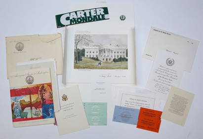
1977 INAUGURATION of PRESIDENT JIMMY CARTERJohn McInnis Auctioneers,LLC4.5(505)See Sold PriceFeb 25, 2024
Willem Blaeu, Etc. 17th C. Antiquarian Maps, 2Auctions at Showplace4.6(744)See Sold PriceMar 17, 2024
Catherwood - General View of Uxmal, Taken from the Archway of Las Monjas, Looking SouthTrillium Antique Prints & Rare Books4.5(33)See Sold PriceFeb 24, 2024
Map: A 19thC engraved and hand coloured map of Buckingham titled A New Map of BuckinghamshireClaydon Auctioneers Ltd4.3(125)See Sold PriceFeb 26, 2024
1704 DESCRIPTION OF ALL THE SEATS OF THE PRESENT WARS OF EUROPE antique w/ MAPSJasper524.5(9.9k)See Sold PriceFeb 27, 2024
West Indies Islands. Guadaloupe. | Mariegalante &C. | Antigua.Jasper524.5(9.9k)See Sold PriceFeb 27, 2024
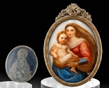
17th C. Niello Plaque + 19th C. Porcelain PaintingArtemis Fine Arts4.8(1.4k)See Sold PriceFeb 26, 2024
JOHN LIGHTFOOT'S 1675 HORAE HEBRAICAE AND TALMUDICAE IS AN OLD JUDAICANY Elizabeth 4.1(88)See Sold PriceMar 03, 2024
ANTIQUE 1686 OPERA OMNIA BY JOHN LIGHTFOOT TELLIMA BOUND FOLIO WITH ISRAEL MAPNY Elizabeth 4.1(88)See Sold PriceMar 03, 2024
1675: ANTIQUE ILLUSTRATED JULIUS CAESAR MAPS OF ROMAN HISTORYNY Elizabeth 4.1(88)See Sold PriceMar 03, 2024