ATLAS of ANTIENT GEOGRAPHY by SAMUEL BUTLER 1843John McInnis Auctioneers,LLC4.6(502)See Sold PriceFeb 24, 2024
18TH C. ANTIQUE MAP: FRENCH & INDIAN WAR, FRAMEDThomaston Place Auction Galleries4.4(386)See Sold PriceFeb 24, 2024
Rand McNally Railroad Map Cabinet w/ 21 Railroad MapsRail & Road Auctions4.6(165)See Sold PriceMar 08, 2024
Keith Haring - Ink on New York Map, Best Buddies, Inscribed, Signed, and DatedSapphire Auction Gallery4(67)See Sold PriceMar 02, 2024
LATE 17TH C. FRENCH MAP OF THE NEW WORLD BY ALEXIS-HUBERT JAILLOT (1632-1712)Thomaston Place Auction Galleries4.4(386)See Sold PriceFeb 24, 2024
Central Railroad of New Jersey Map of Sandy Hook Route-ca. 1903JM Hobby Supply and Railroad Artifact Auctions4.4(126)See Sold PriceFeb 24, 2024
Lot of Six Mixed Atlas Box Cars-HO Scale-New in BoxJM Hobby Supply and Railroad Artifact Auctions4.4(126)See Sold PriceFeb 25, 2024
Rand McNally/Santa Fe Railroad Map of Iowa-1912JM Hobby Supply and Railroad Artifact Auctions4.4(126)See Sold PriceFeb 24, 2024
NICOLAES VISSCHER (NETHERLANDS, 1618-1709) MAP OF THE NEW WORLDThomaston Place Auction Galleries4.4(386)See Sold PriceFeb 24, 2024
17TH C. WORLD MAP BY NICOLAES VISSCHER (NETHERLANDS, 1618-1709)Thomaston Place Auction Galleries4.4(386)See Sold PriceFeb 24, 2024
Lot of Six Mixed Atlas Cabooses-HO Scale-New in BoxJM Hobby Supply and Railroad Artifact Auctions4.4(126)See Sold PriceFeb 25, 2024
Map of Central Italy: Francois Hulma's De Aaloudheden Van Rome (1704)Title: Map of Central Italy: Francois Hulma's De Aaloudheden Van Rome (1704) Date/Period: 1704 Materials: Copperplate engraved, hand colored Size: 17 1/2 x 13 1/2” Explore Central Italy with thiSee Sold Price
Central Italy. 1704 by Francois HulmaTitle: Central Italy. 1704 by Francois Hulma Date/Period: 1704 Materials: Copperplate engraved, hand colored Size: 17 1/2 x 13 1/2” Central Italy centered around Rome. 1704. By Francois Hulma. AmsteSee Sold Price
Map of Central Italy by Francois Hulma (1704)Title: Map of Central Italy by Francois Hulma (1704) Date/Period: 1704 Materials: Copperplate engraved, hand colored Size: 17 1/2 x 13 1/2” Explore central Italy with this fascinating antique maSee Sold Price
SoldKennet Basilde Aaloudheden van Rome_x000D_ Amsterdam, Francois Halma, 1704_x000D_ _x000D_ Folio (342by210mm.), 18 engraved tablesSee Sold Price
Roma - Kennett, Basil - Sewel, Willem De AaloudheRoma - Kennett, Basil - Sewel, Willem De Aaloudheden van Rome, of Beschryving van de Geleerdheyd en Opvoeding der Romeynen ...Amsterdam, François Halma, 1704. In 2?. Bell'antiporta allegorica,See Sold Price
MAP, Central Italy, BodenehrCentral Italy. Gabriel Bodenehr, Italien Eigendlich Also Genandt, from Atlas Curieux, 1704 (published). Hand Color. This detailed, small map depicts central Italy from just past Rome in the south to PSee Sold Price
MAP, Central Italy, Rome, LangenesCentral Italy, Rome. Barent Langenes, Romanum Territorium, 1600 (published). Hand Color. This tiny map focuses on the Territory of Rome and was engraved by Petrus Kaerius (Pieter van den Keere). FrencSee Sold Price
SoldMallet: Antique Map of Central Italy, Papal States 1683Title of the Map: 'Estat Ecclesiastique et Duche de Toscane' Shows the Papal States & the Duchy of Tuscany. Rome. Tuscany and Central Italy. Date Printed: 1683 Image Size: Approx Overall page size 13See Sold Price
CENTRAL ITALY. Duchy of Tuscany & Papal/Ecclesiastical States. MALLET 1683 mapTITLE OF THE MAP: 'Estat Ecclesiastique et Duche de Toscane' (De L'Europe) Shows the Papal States & the Duchy of Tuscany. Rome. Tuscany and Central Italy. DATE PRINTED: 1683 IMAGE SIZE: Approx OverallSee Sold Price
Sold1844 BEAUTIFUL BINDING History of Venice Italy ROME1844 BEAUTIFUL BINDING History of Venice Italy ROME Italian Wars Constantinople A rare historical book in an exquisite, decorative binding! ‘Histoire de Venise’, by Francois Valentin, is a mid-19tSee Sold Price
SoldElwe: Antique Map of Gulf of Mexico & Caribbean, 1792Map: De Golf van Mexico, de Eilanden en het omleggende Land Cartographer: J. B. Elwe Place & Date: Amsterdam / 1792 Size: 22 3/4" x 19" Condition: Wash and outline color; light overall age toning, minSee Sold Price
Notorious Pirate Haven Barbary Coast 1666Map Title: de Cust van Barbaryen (Early Chart of the Notorious Pirate Haven Barbary Coast/ Morocco/ Madeira) Published: GOOS, P., Amsterdam Date: 1666 Size: 17 x 20.75 inches. Fine, early chart of theSee Sold Price
Isaak Tirion: Volk plantingen in Noord AmericaMap: Nieuwe Kaart van de Grootbrittannische Volk plantingen in Noord America Maker: Isaak TirionPublisher: Isaak Tirion, Amsterdam Medium: Copper plate engraving. Original hand coloringDate: ca. 1755SSee Sold Price
de Wit: Antique Dutch Map of Italy, 1680Title: Novissima et Accuratissima totius Italiae Corsicae et Sardiniae Descriptio. Lovely 17th century Dutch map of Italy Map maker: Frederick de Wit Place and Year: Amsterdam, c. 1680 Dimensions: 56.See Sold Price
Sold1766 Geography ATLAS Maps La Croix Francois & Blanchard1766 Geography ATLAS Maps La Croix Francois & Blanchard Illustrated A fine collection of 18th century geography texts – famous works by Blanchard, Abbe Francois, and De La Croix. This lot includes iSee Sold Price
SoldJohannes Blaeu, Seste deel van de Nieuw Atlas 1655Johannes Blaeu, Seste deel van de Nieuw Atlas. Amsterdam, 1655. A Fine Example of the First Atlas of China Published in the Western World with cartography based on domestic Chinese sources. Dutch editSee Sold Price
SoldMID-CENTURY 'SPIDER' SIDE TABLE, CARLO DE CARLIItalian mid-century 'Spider' table, design by Carlo De Carli ( Italy, 1910-1999), c. 1950, a veined white marble top held by six curved arms issuing from central support, raised on a tripod base, 18.7See Sold Price
SoldLarge Post-Revolutionary Map of Eastern and CentralLarge Post-Revolutionary Map of Eastern and Central North AmericaLe Rouge, George-Louis. Carte D'Une Partie De L'Amérique Septentrionale, pour fervir a l'Histoire de la derniére Guerre (Paris, 1See Sold Price
Soldvan der Aa: Antique Map of Southeast US, 1713Map: La Floride Suivant les Nouvelles Observations de Messrs. de l'Academie Royale des Sciences (eastern seaboard to New Mexico) Cartographer: van der Aa Place & Date: Leiden / 1713 Size: 14 7/8" x 10See Sold Price
SoldGeorges Charles COUDRAY (1883-1932) Orientalist statueGeorges Charles COUDRAY (1883-1932) Orientalist bronze statue, signed and titled: "Tahoser, Prix de Rome". Sold a similar statue on 4/18/2008 by $ 14,000.00 by Sotheby's, NY, lot 207, page 351 of theSee Sold Price
Soldc1680 Turkish Manuscript ‐ Francois Petis de lac1680 Turkish Manuscript ‐ Francois Petis de la Croix HISTOIRE DES GUERRES DES TURCS CONTRE LA POLOGNE LA MOSCOVIE L′ALLEMAGNE ET LA REPUBLIQUE DE VENISE Turks Turkey Wars Ottoman Louis XISee Sold Price
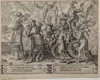
SoldG.B. Piranesi 1720-1778 LG 18thC. Antique Rome MapGiovanni Battista Piranesi (Italian,1720-1778). Large and masterfully produced circa 18th Century map of the City of Rome (Urbi Romani). Black and white representation of original copperplate engravinSee Sold Price
SoldDutch landscape by Jan Van de Velde(attrib),16thcDutch landscape by Jan Van de Velde(attrib), 16thc. Painting is on wood panel, 2.5" x 5.1" in a frame 8"x 11".//////////////////////////From Wiki:"Jan van de Velde the younger (1593 – ca. 1 NovembSee Sold Price
SoldA Barcelona day bed.A Knoll Barcelona Day Bed. 2nd half of 20th century. Designed by Mies van de Rohe. Tan tufted leather upholstery and bolster pillow with rosewood and steel frame. 15"h x 40"w x 76"l.The property of ThSee Sold Price
Central Railroad of New Jersey Map of Sandy Hook Route-ca. 1903JM Hobby Supply and Railroad Artifact Auctions4.4(126)See Sold PriceFeb 24, 2024
Valentina de Casorati (Italy,1863-1919) oil painting antiqueBroward Auction Gallery4.8(277)See Sold PriceMar 31, 2024
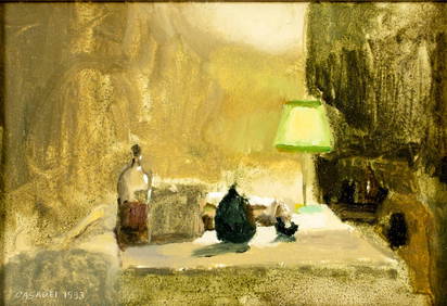
Giovanni Casadei (Italian,PA,b 1956) oil paintingBroward Auction Gallery4.8(277)See Sold PriceMar 31, 2024
LATE 17TH C. FRENCH MAP OF THE NEW WORLD BY ALEXIS-HUBERT JAILLOT (1632-1712)Thomaston Place Auction Galleries4.4(386)See Sold PriceFeb 24, 2024
EARLY 18TH C. DUTCH CHART OF PACIFIC OCEAN BY FREDERIK DE WIT (1629-1706) WITH CALIFORNIA AS ANThomaston Place Auction Galleries4.4(386)See Sold PriceFeb 24, 2024
LARGE EARLY 18TH C. DUTCH CHART OF UPPER NORTH AMERICA, PIERRE MORTIER (1661-1711), FRAMEDThomaston Place Auction Galleries4.4(386)See Sold PriceFeb 24, 2024
Spanish school of the XIX century. After DIEGO DE VEL?ZQUEZ (Seville, 1599 - Madrid, 1660). DetailSetdart Auction House4.1(22)See Sold PriceFeb 28, 2024
Follower of JAN VAN EYCK (1390-1441) . Flemish school, 18th-19th century. "Virgin". Oil on canvas.Setdart Auction House4.1(22)See Sold PriceFeb 28, 2024
Rembrandt van Rijn. Clement de Jonghe, Printseller (1651) New Hollstein 264, IX/X Stout,Tremont Auctions4.6(293)See Sold PriceFeb 25, 2024
Philip Galle. 13 engravings on paper. 16th/17th century. To include: 7 works after Maarten vanTremont Auctions4.6(293)See Sold PriceFeb 25, 2024
Christo Vladimirov Javacheff (1935-2020) and Jeanne-Claude Denat de Guillebon (1935-2009), known asNeely Auction4.6(224)See Sold PriceFeb 25, 2024
Paul Signac (French, 1863-1935) - Le Joueur de Boules Assis (Étude pour 'Au Temps d'Harmonie')Freeman's | Hindman4.5(158)See Sold PriceFeb 27, 2024
Rand McNally Railroad Map Cabinet w/ 21 Railroad MapsRail & Road Auctions4.6(165)See Sold PriceMar 08, 2024
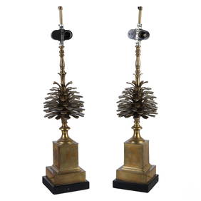
Maison Charles Brass Pomme de Pin Pinecone LampsHill Auction Gallery 4.7(1k)See Sold PriceFeb 28, 2024
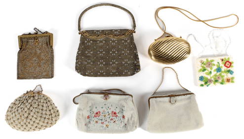
Seven Vintage Purses, Beaded & Wire Mesh, Point de Beauvais, French, Josef, Saks Fifth AvenueHoch LTD.4.5(73)See Sold PriceFeb 25, 2024
De Jode, Rare, pub. 1593 - Map of the Middle East, Eastern Asia (Primae Partis Asiae accurataTrillium Antique Prints & Rare Books4.5(30)See Sold PriceFeb 24, 2024
Kipling's Les plus beaux contes - 24 Engravings by Kees Van DongenTrillium Antique Prints & Rare Books4.5(30)See Sold PriceFeb 24, 2024
Jean Francois Raffaelli. "Paysage de l'Isle-de-France," oilAlex Cooper4.5(496)See Sold PriceMar 02, 2024