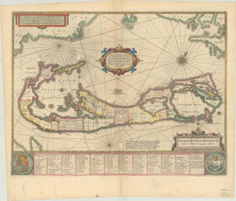
Sold[Map of Bermuda, Schenk and Valk]MAPPA AESTIVARUM INSULARUM SIVE BARMUDAS. Amsterdam: Schenck and Valk, [ca. 1715]. Plate 20.25 x 15.5", sheet 24 x 21". Quite clean and bright though with the following minor flaws: Veritical crease tSee Sold Price
Valk & Schenk: BermudaMap: Mappa Aestivarum Insularum, alias Bermudas Cartographer: Schenk and Valk Place/Date: Amsterdam / 1700 (c.) Size: 19 7/8" x 15 1/8" Condition: "contemporary coloroverall age toning; minor spottingSee Sold Price
SoldSchenk and Valk: BermudaReserve Reduced! Map Title: Mappa Aestivarum Insularum, alias Bermudas Cartographer: Schenk and Valk Place / Date: Amsterdam / 1700 (c.) Size: 19 7/8" x 15 1/8" Condition: contemporary color; overallSee Sold Price
SoldMap of Bermuda 1720Title: Mappa Æstivarum Insularum, alias Barmudas Dictarum ... Accurate Descripta Author: Valk, Gerard & Pieter Schenk Description: Copper-engraved map, hand-colored, with uncolored cartouche, windrosSee Sold Price
SoldMap of Bermuda 1720Title: Mappa Æstivarum Insularum, alias Barmudas Dictarum ... Accurate Descripta Author: Valk, Gerard & Pieter Schenk Description: Copper-engraved map, hand-colored, with colored cartouche, windroseSee Sold Price
Sold1690 Aegypti Recentior Descripto 2 sheet map of Egypth/c map by Schenk & Valk, Amsterdam, 15.5 by 19.5 inchesSee Sold Price
Valk & Schenk map of Caribbean c.1690Title: Insulae Americanae in Oceano Septentrionali cum Terris adiacentibus Author: Valk, Gerard & Pieter Schenk Description: Copper-engraved map, hand-colored in outline. 37.5x51.5 cm. (14¾x20¼").RaSee Sold Price
SoldAndreas Cellarius Map, reissue by Schenk and Valk[Cellarius Map] "Solis Circa Orbem Terrarum Spiralis Revoltio", originally by Andreas Cellarius (c.1596-1665) for the Atlas Coelestis, this example reissued by Schenk and Valk , c. 1708, showing the pSee Sold Price
SoldG. Valk & P. Schenk Map of Ancient Spain C.1650G. Valk & P. Schenk Map of Spain of the Ancient Roman Province, c. 1650. Map titled "Parte de Casiglga". Map measures 24-3/8" x 20-3/8" sheet size. Unframed, loose and not glued or mounted. ProvenanceSee Sold Price
SoldG. Valk & P. Schenk Map of Ancient Spain C.1650G. Valk & P. Schenk Map of Spain of the Ancient Roman Province, c. 1650. Map titled "Parte de Casiglga". Map measures 24-3/8" x 20-3/8" sheet size. Unframed, loose and not glued or mounted. If lot isSee Sold Price
PIETER SCHENK / VALK / JANSSEN Hand Colored Map South Italy ca1702 vgcPIETER SCHENK / VALK / JANSSEN MAP OF RHODESThis original and very rare mapping from the 1702 publication by Schenk & Valk, the Nova Totius Geographia, is in very good condition and measures 21" x 25"See Sold Price
PIETER SCHENK / VALK / JANSSEN Hand Colored Map of Rhodes Greece ca1702 vgcPIETER SCHENK / VALK / JANSSEN MAP OF RHODESThis original and very rare mapping from the 1702 publication by Schenk & Valk, the Nova totius Geographia, is in very good condition and measures 21" x 13"See Sold Price
SoldG. Valk and P. Schenk Map of New EnglandG. Valk and Schenk colored engraved map of New England, circa 1720. Nova Belgica Et Anglia Nova. Shows much of the eastern seaboard from Nova Scotia to Virginia. Framed under glass. Mat opening: 15-1/See Sold Price
After P Schenk & G Valk, Map of the Bishoprike ofAfter P Schenk & G Valk, Map of the Bishoprike of Durham, 40x50See Sold Price
SoldSchenk and Valk, Vectis map, etcSchenk and Valk, Vectis Insulae, hand coloured engraved map of the Isle of Wight, 21 x 49.5cm; Feliks Topolski, Churchill, speech text below, lithograph, 39 x 27cm; together with three small VictorianSee Sold Price
SoldSchenk & Valk, Amsterdam. A country map of PembrokeshirSchenk & Valk, Amsterdam. A country map of Pembrokeshire ('Penbrochia'), with tinted borders and highlights, shields and coronets upper left, cherubs and animals framing a cartouche lower right, 15" xSee Sold Price
SoldSchenk & Valk reissue of Hondius' Virginia c.1694Title: Nova Virginiæ Tabula Author: Hondius, Henricus / Schenk & Valk Description: Copper-engraved map, hand-colored; 2 uncolored pictorial vignettes, an armorial shield, etc. 38x49 cm. (15x19½").SeSee Sold Price
SoldJansson's Virginia & Florida by Valk & SchenkTitle: Virginiae Partis Australis, et Floridae Partis Orientalis, interjacentiumq. Regionum Nova Descriptio Author: Jansson, Jan / Valk & Schenk Description: Copper-engraved map, hand-colored, with unSee Sold Price
SoldJansson's Cuba issued by Valk & SchenkTitle: Insularum Hispaniolae et Cubae Cum Insulis circum jacentibus accurata delineatio Author: Jansson, Jan / Valk & Schenk Description: Copper-engraved map, hand-colored; uncolored pictorial cartoucSee Sold Price
Sold18th century Planetary MapMap titled "Orbium Planetarum Terram Complectentium Scenographia " by G. Valk & P. Schenk, Amsterdam: 1708. Map/chart shows concentric rings of an armillary sphere, showing movements of sun, moon andSee Sold Price
SoldDUTCH HAND COLORED MAP, BANDANENSIUM, P. SCHENKDUTCH HAND COLORED MAP, BANDANENSIUM, SIGNED P. SCHENK ET G. VALK, 17/18TH CENTURY. 17 1/4 X 20 1/4"; FRAMED & GLAZED 25 X 28"See Sold Price
Jansson's New England issued by Valk & SchenkTitle: Belgii Novi, Angliae Novae, et Partis Virginiae Novissima Delineatio Author: Jansson, Jan / Valk & Schenk Description: Copper-engraved map, hand-colored; uncolored pictorial cartouche, dedicatiSee Sold Price
SoldG VALK AND P SCHENKG Valk and P Schenk A map of Gloucestershire and Monmouthshire; Glocestria Ducatus cum Monumethensi, hand coloured engraved map, a good impression 41 x 50.5cmSee Sold Price
SoldG VALK AND P SCHENKG Valk and P Schenk A map of Somersetshire; Somersettensis, hand coloured engraved map, a good impression 38 x 49.5cmSee Sold Price
RARE 1638 HONDIUS MAP OF BERMUDA, FRAMEDThomaston Place Auction Galleries4.4(386)See Sold PriceFeb 24, 2024
EARLY 18TH C. MAP OF ITALY, FRAMEDThomaston Place Auction Galleries4.4(386)See Sold PriceFeb 24, 2024
18TH C. ANTIQUE MAP: FRENCH & INDIAN WAR, FRAMEDThomaston Place Auction Galleries4.4(386)See Sold PriceFeb 24, 2024
MAP - PIETER SCHENK / VALK / JANSSEN Hand Colored superb Map Central Italy c1702Luis Porretta Fine Arts4.3(10)See Sold PriceMar 02, 2024
PIETER SCHENK / VALK / JANSSEN Hand Colored Map of Rhodes Greece ca1702 vgcLuis Porretta Fine Arts4.3(10)See Sold PriceMar 02, 2024
Keith Haring - Ink on New York Map, Best Buddies, Inscribed, Signed, and DatedSapphire Auction Gallery4(67)See Sold PriceMar 02, 2024
Rand McNally Railroad Map Cabinet w/ 21 Railroad MapsRail & Road Auctions4.6(165)See Sold PriceMar 08, 2024
Putnam - First Map of the State of Ohio by Rufus PutnamTrillium Antique Prints & Rare Books4.5(30)See Sold PriceFeb 24, 2024
1750 Bowen Map of Bermuda and St. Kitts -- A New & Accurate Map of Bermudas or Sommer's Islands...Jasper524.5(9.8k)See Sold PriceFeb 27, 2024
![[Map of Bermuda, Schenk and Valk] First Image](https://p1.liveauctioneers.com/3532/95081/48483433_1_x.jpg?height=282&quality=95&version=1476656219&width=282)
![[Map of Bermuda, Schenk and Valk] (1 of 7)](https://p1.liveauctioneers.com/3532/95081/48483433_1_x.jpg?height=282&quality=70&version=1476656219)
![[Map of Bermuda, Schenk and Valk] First Image](https://p1.liveauctioneers.com/3532/95081/48483433_1_x.jpg?height=282&quality=1&version=1476656219&width=282)