1952 ROBERT F. KENNEDY HANDWRITTEN LETTERJohn McInnis Auctioneers,LLC4.6(502)See Sold PriceFeb 25, 2024
CASED PRESENTATION HALF HULL MODEL OF THE BARQUE "HAWTHORNBANK" Last Quarter of the 19th CenturyEldred's4.7(409)See Sold PriceFeb 27, 2024
Lot Of 14 Jack Daniels And Country Club Glass Spirit BottlesRbfinearts4.4(571)See Sold PriceFeb 24, 2024
PR OF 17TH C. SPANISH BRASS CANDLESTICKSThomaston Place Auction Galleries4.4(386)See Sold PriceFeb 24, 2024
Lake Shore and Michigan Southern RR Special Excursions Timetable-July 7-13, 1892JM Hobby Supply and Railroad Artifact Auctions4.4(126)See Sold PriceFeb 24, 2024
Tiffany & Co. Sterling Silver Corkscrew Bottle OpenerSJ Auctioneers4.5(165)See Sold PriceMar 03, 2024
Rolls Royce Landau c1950s Gin/ Scotch TantalusPasadena Antique Auctions4.3(6)See Sold PriceMar 10, 2024
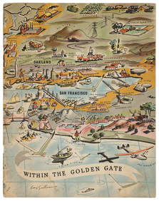
SoldMap of Bay Area ports and facilitiesHeading: (California - San Francisco Bay Area) Author: Rand, McNally & Co. Title: Ports and Facilities on San Francisco Bay, and Tributary Waters Place Published: San Francisco Publisher: Date PuSee Sold Price
Bird's-eye of S.F. Bay port facilitiesHeading: (California - San Francisco Bay Area) Author: Title: San Francisco Bay Area Port Facilities Place Published: San Francisco Publisher:Marine Exchange Inc. Date Published: 1953See Sold Price
Bellin, J. N. Baye Ste Anne dans L' Isle RoyaleBellin, Jaques Nicolas Baye Ste Anne ou le port Dauphin dans L'Isle Royale 1764 Copperplate engraving; coloured Printed area: 30.5 x 20.5 cm; 11.8 x 8 in This precious map shows the bay of St. Anns inSee Sold Price
SoldRare pictorial map of S.F. Bay Area 1905Heading: Author: Whitaker & Ray Co. Title: New Relief Map of the Bay Counties Place Published: San Francisco Publisher: Date Published: 1905 Description: Lithographed map,See Sold Price
SoldRare "Grapho-relief" map of S.F. Bay Area 1907Heading: Author: Whitaker & Ray Co. Title: Grapho-Relief Map of the Bay Counties Compiled from the latest and most accurate Official Data Place Published: San Francisco Publisher: Date PublishedSee Sold Price
SoldMaps, San Francisco Bay Area, 1800s(Lot of 16) Assorted San Francisco Bay Area maps, including: ''Sacramento, Eel and Russian River Basins, Water Resources,'' 1960, ''Southern California Electrical Supply,'' 1923, and ''Forest Map of TSee Sold Price
SoldRare Road Map of S.F. Bay Area 1907Heading: Author: Whitaker & Ray Co. Title: Road Map of the Bay Counties:Compiled from the latest and most accurate official data Place Published: San Francisco Publisher:Whitaker and Ray Co. DatSee Sold Price
SoldBay Area Maps and Guides (117254)Lot of 18 San Francisco Bay Area maps, covers San Jose, Daly City, San Francisco and more, c1950's-70's. Includes a Thomas Bros. map, and two guides for Japanese Village and San Francisco. Provenance:See Sold Price
Geological survey maps of S.F. Bay AreaHeading: (California - San Francisco Bay Area) Author: U.S. Geological Survey Title: Six maps of the San Francisco Bay Area issued by the U.S. Geological Survey Place Published: Washington, D.C. PubliSee Sold Price
Geological survey maps of S.F. Bay AreaHeading: (California - San Francisco Bay Area) Author: U.S. Geological Survey Title: Six maps of the San Francisco Bay Area issued by the U.S. Geological Survey Place Published: Washington, D.C. PubliSee Sold Price
Unknown (19th), Military map of a port facility, Pen drawingUnknown (19th century): Strategic military map of a port facility with river course and information on the deployment of troops, France, 19th century, Pen drawing Technique: Pen drawing on Paper InscrSee Sold Price
Group of six maps to include Boston 1877 AugustusGroup of six maps to include Boston 1877 Augustus Mitchell Johnsons lower Canada, White Plains, Scarsdale, Switzerland, Roman Empire, Geological map San Francisco Bay Area 1853, print of California.See Sold Price
SoldAMERICAN CANADIAN & EUROPEAN PRINTED MAPS THREEAMERICAN, CANADIAN & EUROPEAN PRINTED MAPS, THREE, H 8 3/4"-10 1/2":Including one map of the Bay & Port of New York, and the Capital of New York, by George Hayward, lithographed for D.T. Valentine's MSee Sold Price
SoldRare Russian map of Kodiak Island 1849Heading: Author: Russia, Russian American Company Title: [in Russian] Mercator's Chart of Kodiak Archipelago compiled by the Russian American Company... 1849. [with ten inset maps of bays and ports]See Sold Price
AMERICAN CANADIAN & EUROPEAN PRINTED MAPSAMERICAN, CANADIAN & EUROPEAN PRINTED MAPS, THREE, H 8 3/4"-10 1/2":Including one map of the Bay & Port of New York, and the Capital of New York, by George Hayward, lithographed for D.T. Valentine's MSee Sold Price
SoldGeological Map of San Francisco Bay Area, 1853Title/Content of Map: 1853 Geological Map of San Francisco Bay Area for the Pacific Rail Road -- Geological Map of the Vicinity of San Francisco Date Printed: 1853, Philadelphia Cartographer: W BlakeSee Sold Price
SoldTwo Framed Maps Of The Chesapeake Bay AreaEnglish 18th century; map of Delmar Peninsula, 4 1/4 x 7 in. and map of Chesapeake Bay and adjoining area, hand colored, 5 1/2 x 8 1/2 in., both framed.See Sold Price
SoldVan Keulen map of the Chesapeake Bay AreaVAN KEULEN, Johannes (1654-1715). Pas Kaart van de Zee Kuysten van Virginia. Engraved map with original hand color in part. Amsterdam, circa 1695. 20 3/4” x 24” sheet, 25” x 28 1/2&rSee Sold Price
SoldScarce map of San Francisco Bay Area 1912Heading: (California - San Francisco) Author: Hunt, A.R. Title: The Metropolitan Area of Greater San Francisco Place Published: [San Francisco, Calif.?] Publisher:A.R. Hunt Date Published: 19See Sold Price
SoldMaps, California, South America, Bay Area(lot of 8) 7 maps and 1 box of maps: Unframed color map, County Map of California and Nevada, 1906, with details of San Francisco Bay Area and Lost Angeles; Box with assorted maps, charts, and atlas pSee Sold Price
Motor guide to San Francisco Bay Area with map, 1918Heading: (California - San Francisco) Author: Title: Sixty Miles Around San Francisco with Driving Instructions Place Published: New York Publisher:Home Insurance Company Date Published: 191See Sold Price
SoldGeological Pocket Map of San Francisco Bay AreaTitle: Map Of The Region Adjacent To The Bay Of San Francisco. 1873. The Coast, Rancho, Township and Section Lines from Materials furnished by the U.S. Coast Survey and the U.S. Surveyor General's OffSee Sold Price
SoldRoad map of greater S.F. Bay Area 1926Heading: (California - San Francisco Bay Area) Author: Title: Map of the South Bay touring district Place Published: No place Publisher:National Automobile Club. Date Published: 1926See Sold Price
Antique Geological Map of San Francisco Bay Area, 1853Title/Content of Map: 1853 Geological Map of San Francisco Bay Area for the Pacific Rail Road -- Geological Map of the Vicinity of San Francisco Date Printed: 1853, Philadelphia Cartographer: W BlakeSee Sold Price
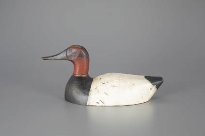
Green-Winged Teal Pair by Gottlieb Schmid (1875-1957)Copley Fine Art Auctions4.5(40)See Sold PriceFeb 24, 2024
Canvasback Decoy by Gottlieb Schmid (1875-1957)Copley Fine Art Auctions4.5(40)See Sold PriceFeb 24, 2024
Proposed Sportsground Map - Haifa, Palestine - 1926Levy Auction House4.3(11)See Sold PriceFeb 27, 2024
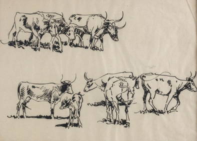
John Edward Borein American 1872-1945 Ink Drawing Long horn cattle w/ COAGlobal Auctions Company4.3(36)See Sold PriceMar 03, 2024
2 5/8" Raddatz. Tan Chert with quartz inclusions. Wisconsin.Tony Putty Artifacts4.7(404)See Sold PriceMar 09, 2024
1764 Bellin Chart of Three South Haitian Bays -- Carte des Bayes du Mesle des Flamands et deJasper524.5(9.8k)See Sold PriceFeb 27, 2024
1764 Bellin Map of Fort Louis Area of Guadeloupe -- Environs du Fort Louis de la GuadeloupeJasper524.5(9.8k)See Sold PriceFeb 27, 2024
Jacques Nicolas Bellin - View of the entrance to Zihuatanejo Bay - View of the entrance to the portProverde Auctions4.3(3)See Sold PriceFeb 28, 2024
LEROY NEIMAN, BAY AREA BASEBALL, SIGNED & NUMBERED SERIGRAPHWhite Knight Auction, Inc4.7(248)See Sold PriceMar 03, 2024