ATLAS of ANTIENT GEOGRAPHY by SAMUEL BUTLER 1843John McInnis Auctioneers,LLC4.6(502)See Sold PriceFeb 24, 2024
18TH C. ANTIQUE MAP: FRENCH & INDIAN WAR, FRAMEDThomaston Place Auction Galleries4.4(386)See Sold PriceFeb 24, 2024
Rand McNally Railroad Map Cabinet w/ 21 Railroad MapsRail & Road Auctions4.6(165)See Sold PriceMar 08, 2024
Keith Haring - Ink on New York Map, Best Buddies, Inscribed, Signed, and DatedSapphire Auction Gallery4(67)See Sold PriceMar 02, 2024
LATE 17TH C. FRENCH MAP OF THE NEW WORLD BY ALEXIS-HUBERT JAILLOT (1632-1712)Thomaston Place Auction Galleries4.4(386)See Sold PriceFeb 24, 2024
Central Railroad of New Jersey Map of Sandy Hook Route-ca. 1903JM Hobby Supply and Railroad Artifact Auctions4.4(126)See Sold PriceFeb 24, 2024
Lot of Six Mixed Atlas Box Cars-HO Scale-New in BoxJM Hobby Supply and Railroad Artifact Auctions4.4(126)See Sold PriceFeb 25, 2024
Rand McNally/Santa Fe Railroad Map of Iowa-1912JM Hobby Supply and Railroad Artifact Auctions4.4(126)See Sold PriceFeb 24, 2024
NICOLAES VISSCHER (NETHERLANDS, 1618-1709) MAP OF THE NEW WORLDThomaston Place Auction Galleries4.4(386)See Sold PriceFeb 24, 2024
17TH C. WORLD MAP BY NICOLAES VISSCHER (NETHERLANDS, 1618-1709)Thomaston Place Auction Galleries4.4(386)See Sold PriceFeb 24, 2024
Lot of Six Mixed Atlas Cabooses-HO Scale-New in BoxJM Hobby Supply and Railroad Artifact Auctions4.4(126)See Sold PriceFeb 25, 2024
MAP - Milan, Italy. MunsterMilan, Italy. Sebastian Munster, Der Statt Meyland Gestalt/ Anfang/ und wie sie Zugenommen hab. , 1588 (published). Hand Color. A nice woodblock view of Milan, showing it as a fortified city enclosedSee Sold Price
SoldMap of Milan region Italy 1640Heading: Author: Blaeu, Willem Title: Stato di Milano Place Published: Amsterdam Publisher: Date Published: c.1640 Description: Copper-engraved map, hand-colored in outline; colSee Sold Price
Map of Milan region Italy 1640Heading: Author: Blaeu, Willem Title: Stato di Milano Place Published: Amsterdam Publisher: Date Published: c.1640 Description: Copper-engraved map, hand-colored in outlineSee Sold Price
Sold[Italy] Milan MapNuova carta dei contorni di Milano e delle province di Como, Bergamo, Cremona e parte di Brescia e Pavia. Incisione in rame, colorata l’idrografia e le città, 600x790 mm, Milano, 1850 ca. Margini.See Sold Price
Sold[Italy-Munster ] Turin MapTaurinum urbs pedemontanus, Munster, 1550 ca.Foglio, con xilografia, 300x210 mm. Lake of Como, Miller, 1830.Incisioni su acciaio, 105x115 mm.Como, Willmore, 1830.Incisione su acciaio, 110x160 mm.See Sold Price
SoldMunster map of Italy, Sicily, etc. 1598Heading: Author: Münster, Sebastian Title: Italia mit dreyen furnemesten Inseln Corsica Sardinia und Sicilia Place Published: Basel Publisher: Date Published: c.1598 Description: <See Sold Price
1702 Homann Map of Northern Italy, Milan Included -- Belli Typus in Italia…Title: 1702 Homann Map of Northern Italy, Milan Included -- Belli Typus in Italia… Cartographer: J Homann Year / Place: 1702 c., Nurnberg Map Dimension (in.): 19 X 22.5 in. This is a magnificent douSee Sold Price
1702 Homann Map of Northern Italy, Milan Included --Title/ Content of Map: 1702 Homann Map of Northern Italy, Milan Included -- Belli Typus in Italia… Cartographer: J Homann Year/Place: 1702 c., Nurnberg Dimensions: 19 X 22.5 in. Description: This isSee Sold Price
1702 Homann Map of Northern Italy, Milan Included --Title/Content of Map: 1702 Homann Map of Northern Italy, Milan Included -- Belli Typus in Italia… Cartographer: J Homann Year/Place: 1702 c., Nurnberg Size: 19 X 22.5 in. This is a magnificent doublSee Sold Price
1702 Homann Map of Northern Italy, Milan Included --Title: 1702 Homann Map of Northern Italy, Milan Included -- Belli Typus in Italia… Cartographer: J Homann Year / Place: 1702 c., Nurnberg Map Dimension (in.): 19 X 22.5 in. This is a magnificent douSee Sold Price
1702 Homann Map of Northern Italy, Milan Included --Title: 1702 Homann Map of Northern Italy, Milan Included -- Belli Typus in Italia… Cartographer: J Homann Year / Place: 1702 c., Nurnberg Map Dimension (in.): 19 X 22.5 in. This is a magnificent douSee Sold Price
1702 Homann Map of Northern Italy, Milan Included --Title: 1702 Homann Map of Northern Italy, Milan Included -- Belli Typus in Italia… Cartographer: J Homann Year / Place: 1702 c., Nurnberg Map Dimension (in.): 19 X 22.5 in. This is a magnificent douSee Sold Price
Sold[MILANO] - Lotto di 5 mappe di varie dimensioni e[MILANO] - Lotto di 5 mappe di varie dimensioni e conservate entro passepartout, tra cui si segnalano quelle di Coronelli e Munster. 5 maps of Milan of various measurments and within passpartouts. AmoSee Sold Price
Sold1550 Munster Map of Southern Italy or Kingdom og Naples -- Regnu NeapolitaTitle: 1550 Munster Map of Southern Italy or Kingdom og Naples -- Regnu Neapolita Cartographer: S Munster Year / Place: 1550, Basel Map Dimension (in.): 8.1 X 5.8 in. This is an excellent woodblock maSee Sold Price
1614 Munster Map of Sardinia, Italy -- Sardina InsulaTitle: 1614 Munster Map of Sardinia, Italy -- Sardina Insula Cartographer: S Munster Year / Place: 1614, Basel Map Dimension (in.): 10 X 5.9 in. This is an excellent woodblock map of Sardinia It showsSee Sold Price
1614 Munster Map of Sardinia, Italy -- Sardina InsulaTitle: 1614 Munster Map of Sardinia, Italy -- Sardina Insula Cartographer: S Munster Year / Place: 1614, Basel Map Dimension (in.): 10 X 5.9 in. This is an excellent woodblock map of Sardinia It showsSee Sold Price
1614 Munster Map of Sardinia, Italy -- Sardina InsulaTitle: 1614 Munster Map of Sardinia, Italy -- Sardina Insula Cartographer: S Munster Year / Place: 1614, Basel Map Dimension (in.): 10 X 5.9 in. This is an excellent woodblock map of Sardinia It showsSee Sold Price
1614 Munster Map of Sardinia, Italy -- Sardina InsulaTitle: 1614 Munster Map of Sardinia, Italy -- Sardina Insula Cartographer: S Munster Year/Place: 1614, Basel Dimensions: 10 X 5.9 in. Description: This is an excellent woodblock map of Sardinia It shoSee Sold Price
SoldLarge map of Africa in early 19th centuryHeading: Author: Bordiga Fratelli Title: Carta dell' Affrica Place Published: [Milan, Italy] Publisher:Fratelli Bordiga Date Published: [1818?] Description: Copper-engravedSee Sold Price
Baldwin & Cradock: Map of Milan, 1832The meticulously detailed Society for the Diffusion of Useful Knowledge plan of Milan, Italy, with major thoroughfares and public places and buildings named. The note on the upper right corner gives ESee Sold Price
DOUBLE-PAGE ENGRAVED MAP OF MEDIOLANUMthe Roman name for Milan, Italy, depicting town buildings, roads and fortifications, coat of arms in upper right, uncolored, 11x14in. The Knoop CollectionSee Sold Price
Large map of Africa in early 19th centuryHeading: Author: Bordiga Fratelli Title: Carta dell' Affrica Place Published: [Milan, Italy] Publisher:Fratelli Bordiga Date Published: [1818?] Description: Copper-engravedSee Sold Price
Antique Map Print - Europe - Northern Italy - Corsica - Milan - Vaugondy 1806Title/Content: Antique Map Print - Europe - Northern Italy - Corsica - Milan - Vaugondy 1806 Date: 1806 Material: Paper Dimensions: 12” x 9” inches / 31,5 cm x 24 cm Description: OriginalSee Sold Price
SoldMediolanum [Milan, Italy]Georg Braun & Frans Hogenberg, Mediolanum [Milan, Italy], engraving (hand colored), ca. 1575, 19 x 13.5 19 x 13.5See Sold Price
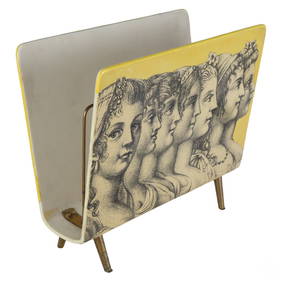
Piero Fornasetti Black & White Faces Magazine RackHill Auction Gallery 4.7(1k)See Sold PriceFeb 28, 2024
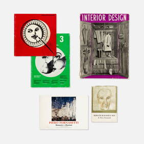
Commune di Parma, Interior Design, et. al., Piero Fornasetti, BooksCatalog Projects4.5(60)See Sold PriceFeb 28, 2024
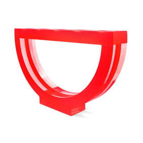
Laminated Acrylic Ospiti Collection Sculpture by Andrea Anastasio for Design Gallery Milano (1999)Jasper524.5(9.8k)See Sold PriceFeb 27, 2024
Cooke, George 1801 Antique Map. Italy, Sicily, Sardinia & CorsicaAlbion Auctions4.6(336)See Sold PriceMar 01, 2024
Blackie (Pub) 1882 Pair of Folio Maps. Italy - North & SouthAlbion Auctions4.6(336)See Sold PriceMar 01, 2024


![[Italy] Milan Map (1 of 1)](https://p1.liveauctioneers.com/3336/90951/47432068_1_x.jpg?height=282&quality=70&version=1473763184)
![[Italy-Munster ] Turin Map (1 of 4)](https://p1.liveauctioneers.com/3336/90951/47432130_1_x.jpg?height=282&quality=70&version=1473763184)


![[MILANO] - Lotto di 5 mappe di varie dimensioni e (1 of 1)](https://p1.liveauctioneers.com/3662/175274/88222372_1_x.jpg?height=282&quality=70&version=1597918246)


![Mediolanum [Milan, Italy] (1 of 1)](https://p1.liveauctioneers.com/457/2714/1174187_1_x.jpg?height=282&quality=70)