ATLAS of ANTIENT GEOGRAPHY by SAMUEL BUTLER 1843John McInnis Auctioneers,LLC4.6(504)See Sold PriceFeb 24, 2024
18TH C. ANTIQUE MAP: FRENCH & INDIAN WAR, FRAMEDThomaston Place Auction Galleries4.4(389)See Sold PriceFeb 24, 2024
Rand McNally Railroad Map Cabinet w/ 21 Railroad MapsRail & Road Auctions4.6(165)See Sold PriceMar 08, 2024
Keith Haring - Ink on New York Map, Best Buddies, Inscribed, Signed, and DatedSapphire Auction Gallery4.1(67)See Sold PriceMar 02, 2024
LATE 17TH C. FRENCH MAP OF THE NEW WORLD BY ALEXIS-HUBERT JAILLOT (1632-1712)Thomaston Place Auction Galleries4.4(389)See Sold PriceFeb 24, 2024
Central Railroad of New Jersey Map of Sandy Hook Route-ca. 1903JM Hobby Supply and Railroad Artifact Auctions4.4(126)See Sold PriceFeb 24, 2024
Lot of Six Mixed Atlas Box Cars-HO Scale-New in BoxJM Hobby Supply and Railroad Artifact Auctions4.4(126)See Sold PriceFeb 25, 2024
Rand McNally/Santa Fe Railroad Map of Iowa-1912JM Hobby Supply and Railroad Artifact Auctions4.4(126)See Sold PriceFeb 24, 2024
NICOLAES VISSCHER (NETHERLANDS, 1618-1709) MAP OF THE NEW WORLDThomaston Place Auction Galleries4.4(389)See Sold PriceFeb 24, 2024
17TH C. WORLD MAP BY NICOLAES VISSCHER (NETHERLANDS, 1618-1709)Thomaston Place Auction Galleries4.4(389)See Sold PriceFeb 24, 2024
Lot of Six Mixed Atlas Cabooses-HO Scale-New in BoxJM Hobby Supply and Railroad Artifact Auctions4.4(126)See Sold PriceFeb 25, 2024
MAP - Mid-Atlantic US. Seutter/LotterColonial Mid-Atlantic United States. Seutter/Lotter, Pensylvania Nova Jersey et Nova York cum Regionibus ad Fluvium Delaware in America Sitis, Nova Delineatione ob Oculos Posita, 1750 (circa). Hand CoSee Sold Price
MAP, New England & Mid-Atlantic US, SeutterColonial New England & Mid-Atlantic United States. Seutter/Lotter, Recens Edita Totius Novi Belgii, in America Septentrionali Siti, Delineatio Cura et Sumtibus, 1760 (circa). Hand Color. This dramaticSee Sold Price
MAP, Mid-Atlantic US, LotterColonial Mid-Atlantic United States. Tobias Conrad Lotter, Pensylvania Nova Jersey et Nova York cum Regionibus ad Fluvium Delaware in America Sitis, Nova Delineatione ob Oculos Posita, 1760 (circa). HSee Sold Price
MAP, Mid-Atlantic US, Browne/SenexMap of Chesapeake Bay Based on Landmark Herrman Map. Colonial Mid-Atlantic United States. Browne/Senex, A New Map of Virginia Mary-land and the Improved Parts of Pennsylvania & New Jersey..., from NewSee Sold Price
MAP - Mid-Atlantic US. SalmonColonial Mid-Atlantic United States. Thomas Salmon, A Map of Virginia and Maryland, 1767 (circa). Black & White. Of the dozens of editions of A New Geographical and Historical Grammar that were publisSee Sold Price
MAP - Mid-Atlantic US. HomannColonial Mid-Atlantic United States. Johann Baptist Homann, Virginia Marylandia et Carolina in America Septentrionali Britannorum Industria Excultae, 1730 (circa). Hand Color. This handsome map of theSee Sold Price
MAP, Mid-Atlantic US, Robert de VaugondyAn Essential Map of Virginia and Maryland. Mid-Atlantic United States. Didier Robert de Vaugondy, Carte de la Virginie et du Maryland Dressee sur la Grande Carte Angloise de Mrs. Josue Fry et Pierre JSee Sold Price
MAP, Mid-Atlantic US, JanssonColonial Mid-Atlantic United States. Jan Jansson, Nova Virginiae Tabula, 1630 (published). Hand Color. This delicately engraved map is a reduced version of John Smith's map of the Chesapeake Bay regioSee Sold Price
MAP - Mid-Atlantic US. HondiusColonial Mid-Atlantic United States. Hondius/Schenk & Valck, Nova Virginiae Tabula, 1700 (circa). Hand Color. This graphic map is Henricus Hondius' version of Capt. John Smith's important map of 1612,See Sold Price
MAP - Mid-Atlantic US. HomannColonial Mid-Atlantic United States. Johann Baptist Homann, Virginia Marylandia et Carolina in America Septentrionali Britannorum Industria Excultae Repraesentatae, 1730 (circa). Hand Color. This handSee Sold Price
MAP - Mid-Atlantic US. JanssonColonial Mid-Atlantic United States. Jan Jansson, Nova Virginiae Tabula, 1631 (published). Black & White. This delicately engraved map is a reduced version of John Smith's map of the Chesapeake Bay reSee Sold Price
MAP, Mid-Atlantic US, HomannMap Created to Promote German Immigration to the New World. Colonial Mid-Atlantic United States. Johann Baptist Homann, Virginia Marylandia et Carolina in America Septentrionali Britannorum IndustriaSee Sold Price
MAP - Mid-Atlantic US. U.S. GovMid-Atlantic United States. U.S. Gov., Map of a Reconnaissance Between Baltimore and Philadelphia Exhibiting the Several Routes of the Mail-Road Contemplated by the Resolution of Congress Approved onSee Sold Price
SoldMAP, Mid-Atlantic US, Laurie & WhittleLaurie & Whittle's Popular Map Depicting the "New" United States. Mid-Atlantic United States. Laurie & Whittle, A New and General Map of the Middle Dominions Belonging to the United States of America,See Sold Price
SoldMAP, Mid-Atlantic US, HintonPennsylvania, New Jersey, Delaware. Hinton, Simpkin & Marshall, Map of the States of Pennsylvania, and New Jersey, 1832 (circa). Black & White. This finely detailed map also shows all of Delaware, altSee Sold Price
MAP - Colonial Mid-Atlantic US. CloppenburghColonial Mid-Atlantic United States. Mercator/Cloppenburgh, Nova Virginiae Tabula, 1630 (circa). Black & White. This delicately engraved map is a reduced version of John Smith's map of the ChesapeakeSee Sold Price
MAP - Colonial Mid-Atlantic US. JanssonColonial Mid-Atlantic United States. Jan Jansson, Nova Virginiae Tabula, 1631 (published). Black & White. This delicately engraved map is a reduced version of John Smith's map of the Chesapeake Bay reSee Sold Price
SoldBeers: Antique Map of Mid Atlantic Midwest US, 1875Title: 1875 Warner Beers Map of Mid Atlantic and Midwest United States -- County Map of New York, New Jersey, Pennsylvinia, Ohio, Deleware, Maryland, Virginia, West Virginia Cartographer: Warner BeersSee Sold Price
SoldMAP, New England & Mid-Atlantic US, HomannColonial New England & Mid-Atlantic United States. Johann Baptist Homann, Nova Anglia Septentrionali Americae Implantata Anglorumque Coloniis Florentissima, 1730 (circa). Hand Color. This handsome mapSee Sold Price
MAP, New England & Mid-Atlantic US, JanssonColonial New England & Mid-Atlantic United States. Jan Jansson, Nova Belgica et Anglia Nova, 1646 (circa). Hand Color. Jansson's influential map of the eastern coast of North America was first issuedSee Sold Price
MAP - New England & Mid-Atlantic US. BlaeuColonial New England & Mid-Atlantic United States. Willem Blaeu, Nova Belgica et Anglia Nova, 1643 (circa). Hand Color. This important map, first issued in 1635, is one of the first to focus on the DuSee Sold Price
SoldMAP, New England & Mid-Atlantic US, JanssonJansson's Influential Map of the East Coast - in Contemporary Color. Colonial New England & Mid-Atlantic United States. Jan Jansson, Nova Belgica et Anglia Nova, from Atlas Novus, 1646 (circa). Hand CSee Sold Price
MAP, New England & Mid-Atlantic US, JanssonJansson's Influential Map of the East Coast - in Contemporary Color. Colonial New England & Mid-Atlantic United States. Jan Jansson, Nova Belgica et Anglia Nova, from Atlas Novus, 1646 (circa). Hand CSee Sold Price
Sold[U.S./MID-ATLANTIC]. Johnson's Pennsylvania V[U.S./MID-ATLANTIC]. Johnson's Pennsylvania Virginia Delaware And Maryland. 1860s Double-page hand-color lithograph map, slightly toned at edges, short splits at each end of vertical fold. Framed. ThiSee Sold Price
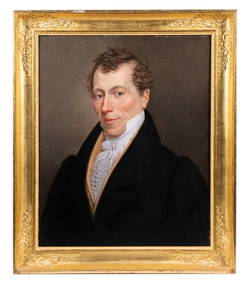
PORTRAIT OF A NEW ENGLAND GENTLEMAN, CA 1810Thomaston Place Auction Galleries4.4(389)See Sold PriceFeb 24, 2024
Mid Atlantic Air Museum Die Cast Airplane BankCheck the Oil Promotions, LLC4.6(305)See Sold PriceMar 03, 2024
6 Cherry Centennial Queen Anne ChairsBroken Arch Auction Gallery NCFL#93994.6(294)See Sold PriceMar 04, 2024
American Mahogany Chippendale ChestBroken Arch Auction Gallery NCFL#93994.6(294)See Sold PriceMar 04, 2024
Joh Leopotof (US, mid 20C) oil painting antiqueBroward Auction Gallery4.8(285)See Sold PriceMay 19, 2024
GROUP OF DECOY CATALOGS AND MAGAZINESFrank and Frank Sporting Collectibles LLC4.7(166)See Sold PriceMar 10, 2024


![[U.S./MID-ATLANTIC]. Johnson's Pennsylvania V (1 of 1)](https://p1.liveauctioneers.com/179/10971/2682783_1_x.jpg?height=282&quality=70&version=1162265652)