ATLAS of ANTIENT GEOGRAPHY by SAMUEL BUTLER 1843John McInnis Auctioneers,LLC4.5(505)See Sold PriceFeb 24, 2024
18TH C. ANTIQUE MAP: FRENCH & INDIAN WAR, FRAMEDThomaston Place Auction Galleries4.4(393)See Sold PriceFeb 24, 2024
Rand McNally Railroad Map Cabinet w/ 21 Railroad MapsRail & Road Auctions4.6(165)See Sold PriceMar 08, 2024
Keith Haring - Ink on New York Map, Best Buddies, Inscribed, Signed, and DatedSapphire Auction Gallery4.1(67)See Sold PriceMar 02, 2024
LATE 17TH C. FRENCH MAP OF THE NEW WORLD BY ALEXIS-HUBERT JAILLOT (1632-1712)Thomaston Place Auction Galleries4.4(393)See Sold PriceFeb 24, 2024
Central Railroad of New Jersey Map of Sandy Hook Route-ca. 1903JM Hobby Supply and Railroad Artifact Auctions4.4(127)See Sold PriceFeb 24, 2024
Lot of Six Mixed Atlas Box Cars-HO Scale-New in BoxJM Hobby Supply and Railroad Artifact Auctions4.4(127)See Sold PriceFeb 25, 2024
Rand McNally/Santa Fe Railroad Map of Iowa-1912JM Hobby Supply and Railroad Artifact Auctions4.4(127)See Sold PriceFeb 24, 2024
NICOLAES VISSCHER (NETHERLANDS, 1618-1709) MAP OF THE NEW WORLDThomaston Place Auction Galleries4.4(393)See Sold PriceFeb 24, 2024
17TH C. WORLD MAP BY NICOLAES VISSCHER (NETHERLANDS, 1618-1709)Thomaston Place Auction Galleries4.4(393)See Sold PriceFeb 24, 2024
Lot of Six Mixed Atlas Cabooses-HO Scale-New in BoxJM Hobby Supply and Railroad Artifact Auctions4.4(127)See Sold PriceFeb 25, 2024
SoldMap : John Speed c 1610 , on Whatman like lined paper,Map : John Speed c 1610 , on Whatman like lined paper, copper engraved with hand colouring and English Text , a coloured map of Wales with vignetted to left side of various towns and pages glazed versSee Sold Price
SoldJohn Speed 17th C Colored Map, Somerset ShireJohn Speed 17th C Colored Engraved Map, Somerset Shire, Englandwith coats of arms.Sudbury & Humble EditionDated: 1610, lower right.Dimensions: 20 1/4" x 15 1/4"Condition: Printed on hand made paper. VSee Sold Price
Speed Map of Dorsetshyre*** START PRICE IS THE RESERVE *** [Europe] SPEED, John (1552-1629). Dorsetshyre with the Shyre-Towne Dorechester Described... Engraved map with hand color in full. London, c. 1610. 16" x 21" visible,See Sold Price
SoldJOHN SPEED COPPERPLATE MAP RADNOR, C1610Original copperplate map with later coloring. Unexamined out of frame. Dimensions: (Frame) H 19” x W 24” (Sight) H 15.25” x W 20” Condition: Map with center fold. Slight toning. Condition:See Sold Price
SoldJOHN SPEED COPPERPLATE MAP BEDFORDSHIRE C1610Original copperplate engraving. Later hand coloring. Unexamined out of frame. Dimensions: (Frame) H 19.5” x W 24.75” (Sight) H 15.5” x W 20.75 Condition: Center fold. Age toning Condition:See Sold Price
Sold(MAP) SPEED, JOHN. The Province of Connaugh. London,(MAP) SPEED, JOHN The Province of Connaugh. [London, c. 1610] Engraved map with later hand-coloring, text to verso. With decorative cartouche, compass rose and vignette of the city of Galwaye to lowerSee Sold Price
SoldMAP: MERIONETH SHIRE, JOHN SPEED, ENGRAVINGTitle: Map: Merioneth Shire Described, Pub: John Speed, Date: 1610, Medium: HC Engraving, Paper size: 15 1/4 x 20 1/4, Inscribed: Publisher identified within matrix, Condition: Good condition; backedSee Sold Price
SoldA monochromatic map of 'The Countie of Nottingham'A monochromatic map of 'The Countie of Nottingham' described 'The Shire Townes Situation and the Earls thereof observed' by John Speed and dated c1610. 52 x 40cm. Slightly AF to centrefold.See Sold Price
Speed, John (1552-1629). A 17th-century map ofSpeed, John (1552-1629). A 17th-century map of Nottinghamshire, hand-coloured copper engraving on laid/chain-lined paper, featuring heraldic shields and inset view of Nottingham, originally removed fSee Sold Price
SoldSpeed Map of CarolinaA New Description of Carolina. John Speed (c. 1552-1629). Engraved map with original hand color. London, 1676. 16 3/4 x 22 inches visible, 22 x 27 inches framed.See Sold Price
SoldJames I Map of Pallatine County England 1610(c.1610) map of Pallatine, Lancaster. Described, divided, hand coloured and engraved by John Speed. Includes portraits of Lancaster royalty. English text verso H. 8cm (15in). L. 51cm (20 1/4in). out oSee Sold Price
SoldJohn Speed,Huntingtonshire, hand coloured engraved map for George Humbell, c.1610, English text verso, double glazed, 40.5 x 53cm; together with a British passport dated 1888 for the Auerbach family, 38 x 27cm (See Sold Price
SoldA framed antique map, John Speed1610, London Hand-tinted copper-engraved map on paper under glass, Cardiganshire, taken from a book plate, by John Speed Image: 15" H x 20" W Provenance: Private Collection, Newport Beach, CA. Notes:See Sold Price
SoldJohn SpeedBedfordshire, hand coloured engraved map published by George Humbel, c.1610, a little browned, 38 x 51cm; W. Blaeu, Map of Pomerania , after Eilhardo Lubino, hand coloured engraving, 38.5 x 49.5cm (brSee Sold Price
Sold2 Maps. Oxfordshire and Scotia Regnum.[Great Britain] 2 Maps. Hole, William. "Scotia Regnum." c. 1610. Engraved map. Hand colored. Image: 12 1/4" x 10 1/4". Framed: 19 1/2" x 17 1/2". ++ Speed, John. "Oxfordshire described with ye Citie aSee Sold Price
Speed map of DorsetshireSPEED, John (1552-1629). Dorsetshyre with the Shyre-Towne Dorechester Described...Engraved map with hand color in full. London, c. 1610. 16 1/2" x 21 3/4" sheet, 26" x 31" framed. Great color and a clSee Sold Price
SoldSpeed (John) Cornwall, hand-coloured engraved map onSpeed (John) Cornwall, hand-coloured engraved map on laid paper, inscription at foot, c. 390 x 510 mm, central vertical fold, laid down, framed and glazed, Roger Rea the elder and younger, 1662 [1665]See Sold Price
SoldMarionethshire, John Speede cartographer [c. 1676Speed, John. Merionethshire Described 1610. Map of Marionethshire, Wales. Includes Gwynneth. [Lon]: John Speede mapmaker, sold by Thomas Bassett and Richard Chiswellin, c.1676. Engraved map, uncoloredSee Sold Price
Speed Map of WalesSpeed, John (1552-1629). Wales. Engraved map with original hand color in full. London, 1610. 16 1/2" x 21 1/2" sheet. Incredibly colored map of Wales with 16 bird's-eye-views of Welsh towns in the borSee Sold Price
Speed Map of Norfolk, EnglandSPEED, John (1552-1629). Norfolk... Engraved map with original hand color. London, 1610 [1612, Latin Text]. 16 5/8" x 21 3/4" sheet.See Sold Price
Speed Map of Leicester, EnglandSPEED, John (1552-1629). Leicester. Engraved map with original hand color. London, 1610 [1612, Latin Text]. 16 5/8" x 21 3/4" sheet.See Sold Price
SoldJohn SpeedJohn Speed Darbieshire described hand coloured engraved map 1610, published Sudbury and Humble, English text verso, paper rather greyed, centre fold with tear, 39 x 52cmSee Sold Price
Sold1610 John Speede Engraved Antique Map Of Surrey17th C John Speede Map Of Surrey. Surrey Described And Divided Into Hundreds' By John Speed Dated 1610. Includes View Of Richmont And Nonsuch Castles. London And The Thames Are Visible In The Upper PaSee Sold Price
SoldBritain.- Speed (John) The Kingdome of England, engraving, [c. 1676]Britain.- Speed (John) The Kingdome of England, eight costumed figures in margins, the seas populated with monsters and ships, engraving with hand-colouring, on laid paper with armorial watermark, plaSee Sold Price
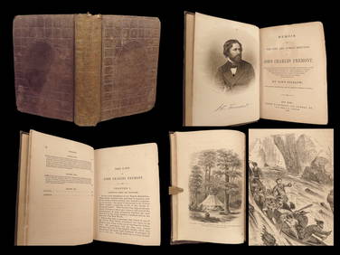
1856 CALIFORNIA 1st ed Memoir John C. Fremont Expeditions Oregon Trail IndiansSchilb Antiquarian Rare Books4.8(428)See Sold PriceMar 10, 2024
17TH C. WORLD MAP BY NICOLAES VISSCHER (NETHERLANDS, 1618-1709)Thomaston Place Auction Galleries4.4(393)See Sold PriceFeb 24, 2024
17TH C. ANTIQUE MAP SIEGE OF LA ROCHELLE, FRANCE, FRAMEDThomaston Place Auction Galleries4.4(393)See Sold PriceFeb 24, 2024
17TH C. MAP OF THE BERKSHIRES BY JOHN SPEED, FRAMEDThomaston Place Auction Galleries4.4(393)See Sold PriceFeb 24, 2024
17TH C. ENGLISH LINEAR MAP BY OGILBY, FRAMEDThomaston Place Auction Galleries4.4(393)See Sold PriceFeb 24, 2024
LARGE MAITLAND-SMITH LEATHER-CLAD STORAGE COFFEE TABLE ON PAW FEETAustin Auction Gallery4.7(1.2k)See Sold PriceFeb 25, 2024
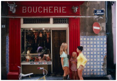
Slim Aarons (1916-2006), "Saint-Tropez Boucherie," 1971, C-print in colors on paper, 40" H x 58.5" WJohn Moran Auctioneers, Inc.4.7(461)See Sold PriceFeb 27, 2024
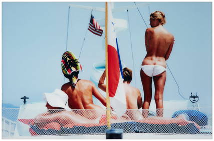
Slim Aarons (1916-2006), "Yacht Holiday," 1967, C-print in colors on paper, 39" H x 60" WJohn Moran Auctioneers, Inc.4.7(461)See Sold PriceFeb 27, 2024
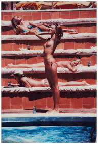
Slim Aarons (1916-2006), "Catherine Wilkie Sunbathing on Capri," 1980, C-print in colors on paper,John Moran Auctioneers, Inc.4.7(461)See Sold PriceFeb 27, 2024
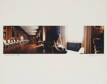
Sam Taylor-Johnson (b. 1967), "Looking Out," 2002, C-print on paper, Image: 6.25" H x 22" W; Sight:John Moran Auctioneers, Inc.4.7(461)See Sold PriceFeb 27, 2024
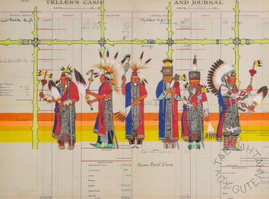
TAE NAH TAHN (KIOWA, 21ST C.) GOUACHE ON LEDGER PAGESoulis Auctions4.8(953)See Sold PriceFeb 24, 2024
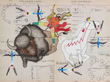
TAE NAH TAHN (KIOWA, 21ST C.) GOUACHE ON LEDGER PAGESoulis Auctions4.8(953)See Sold PriceFeb 24, 2024
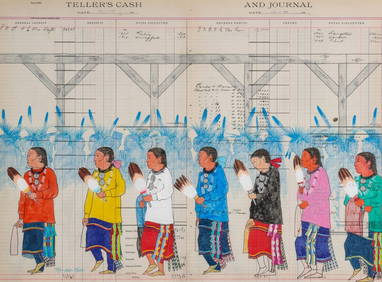
TAE NAH TAHN (KIOWA, 21ST C.) GOUACHE ON LEDGER PAGESoulis Auctions4.8(953)See Sold PriceFeb 24, 2024
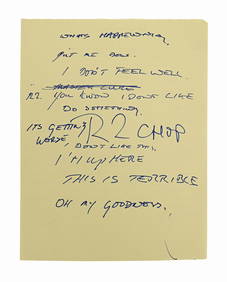
TAE NAH TAHN (KIOWA, 21ST C.) GOUACHE ON LEDGER PAGESoulis Auctions4.8(953)See Sold PriceFeb 24, 2024
ANTIQUE SCOTTISH PETRA ENGRAVING BY DAVID ROBERTSAntique Arena Inc.4.5(878)See Sold PriceFeb 24, 2024
STAR WARS: RETURN OF THE JEDI (1983) - Anthony Daniels Collection: Anthony Daniels' HandwrittenPropstore4.2(6)See Sold PriceMar 13, 2024
NASA Facts JFK Space Center Booklet And MoreRapid Estate Liquidators and Auction Gallery4.5(1.1k)See Sold PriceFeb 24, 2024


![Britain.- Speed (John) The Kingdome of England, engraving, [c. 1676] (1 of 1)](https://p1.liveauctioneers.com/5458/268810/140590907_1_x.jpg?height=282&quality=70&version=1668514381)


![[Ambrotype] Identified Tennessee Soldier (1 of 3)](https://p1.liveauctioneers.com/7226/317626/170485496_1_x.jpg?height=282&quality=70&version=1706368022)