ATLAS of ANTIENT GEOGRAPHY by SAMUEL BUTLER 1843John McInnis Auctioneers,LLC4.6(502)See Sold PriceFeb 24, 2024
18TH C. ANTIQUE MAP: FRENCH & INDIAN WAR, FRAMEDThomaston Place Auction Galleries4.4(386)See Sold PriceFeb 24, 2024
Rand McNally Railroad Map Cabinet w/ 21 Railroad MapsRail & Road Auctions4.6(165)See Sold PriceMar 08, 2024
Keith Haring - Ink on New York Map, Best Buddies, Inscribed, Signed, and DatedSapphire Auction Gallery4(67)See Sold PriceMar 02, 2024
LATE 17TH C. FRENCH MAP OF THE NEW WORLD BY ALEXIS-HUBERT JAILLOT (1632-1712)Thomaston Place Auction Galleries4.4(386)See Sold PriceFeb 24, 2024
Central Railroad of New Jersey Map of Sandy Hook Route-ca. 1903JM Hobby Supply and Railroad Artifact Auctions4.4(126)See Sold PriceFeb 24, 2024
Lot of Six Mixed Atlas Box Cars-HO Scale-New in BoxJM Hobby Supply and Railroad Artifact Auctions4.4(126)See Sold PriceFeb 25, 2024
Rand McNally/Santa Fe Railroad Map of Iowa-1912JM Hobby Supply and Railroad Artifact Auctions4.4(126)See Sold PriceFeb 24, 2024
NICOLAES VISSCHER (NETHERLANDS, 1618-1709) MAP OF THE NEW WORLDThomaston Place Auction Galleries4.4(386)See Sold PriceFeb 24, 2024
17TH C. WORLD MAP BY NICOLAES VISSCHER (NETHERLANDS, 1618-1709)Thomaston Place Auction Galleries4.4(386)See Sold PriceFeb 24, 2024
Lot of Six Mixed Atlas Cabooses-HO Scale-New in BoxJM Hobby Supply and Railroad Artifact Auctions4.4(126)See Sold PriceFeb 25, 2024
MAP, France & Italy, DelisleSoutheastern France & Northwestern Italy. Guillaume Delisle, Partie Meridionale du Piemont et du Monferrat, 1707 (dated). Hand Color. Large map of southern France covering the region from Nice and MonSee Sold Price
MAP - France & Italy. DelisleSoutheastern France & Northwestern Italy. Guillaume Delisle, Partie Meridionale du Piemont et du Monferrat, 1707 (dated). Hand Color. Large map of southern France covering the region from Nice and MonSee Sold Price
1792 L'Italie Dressee sur les Observations de Mrs. deA fine large map of all of Italy including Sicily Sardinia and Corsica the surrounding parts of France and the Balkans. It is based on the geography of Guillaume Delisle and the observations of the asSee Sold Price
1792 L'ItalieA fine large map of all of Italy including Sicily Sardinia and Corsica the surrounding parts of France and the Balkans. It is based on the geography of Guillaume Delisle and the observations of the asSee Sold Price
SoldVarious Maps [France, Italy, Switzerland, Turkey]1) Restrike of (exact date unknown) of 'Pede Monta Nae Vici Norumque Regionum Avc Tore ia Cobo Cas Taldo de Scri;' map of France and Italy from original map by Abraham Ortelius (Flemish 1527-1598) CarSee Sold Price
SoldMAP, Italy, DelisleItaly. Delisle/Buache, L'Italie Dressee sur les Observations de Mrs. de l'Academie Royale des Sciences..., 1745 (dated). Hand Color. A fine large map showing all of Italy, including Sicily, Sardinia aSee Sold Price
Pedemontana Regio Map [France, Italy Map]Restrike of (exact date unknown) of 'Pede Monta Nae Vici Norumque Regionum Avc Tore ia Cobo Cas Taldo de Scri;' map of France and Italy from original map by Abraham Ortelius (Flemish 1527-1598) CartogSee Sold Price
France, Italy, Portugal and Spain.Title/Content of Map: France, Italy, Portugal and Spain. Date: 1852 Cartographer: Mitchell Size: 12 x 9 1/2” Provenance: Philadelphia Additional Info: From ‘school atlas’. Reserve: $25.00 ShippiSee Sold Price
SoldMAP, France, Switzerland & Italy, ChatelainFrance, Switzerland & Italy. Henry Abraham Chatelain, Carte Historique et Geographique pour Introduire a l'Intelligence de l'Histoire de Savoye, et a la Connoissance du Gouverment de cet Etat, 1720 (cSee Sold Price
MAP - Northern France. DelisleNorthern France. Guillaume Delisle, Carte Topographique du Diocese de Senlis..., 1709 (dated). Hand Color. Beautifully engraved map of the region just north of Paris includes le Plessis Belleville, DaSee Sold Price
d'Anville: Antique Map of Western Europe, 1815Title/Content of Map: 'Germany, France, Italy, Spain, & the British Isles during the age between the Ancient and Modern Geography by d'Anville' Date Printed: 1815 Image Size: Approx 56.5 x 50.5cm, 22.See Sold Price
SoldHAND COLOURED ITALIAN 16thC MAP ORTELIUSItalian hand coloured two-page map of France, Italy and the Low Countries, by Ortelius.See Sold Price
SoldCollection of WWII Period MapsLarge collection of WWII-period maps of the European theatre, both city and country maps, Germany, France, Italy, etc., together with a few other countries mixed in, approximately sixty (60) maps of vSee Sold Price
SoldAbraham Ortelius, Maps of France and Italy, Group of 2Lot 51 Abraham Ortelius, Maps of France and Italy, Group of 2 one map inscribed Galliae Regni Potentiss. Nova Descriptio, Ioanne Ioliveto Auctore, depicting France in the second half of the 16th centSee Sold Price
1812 Malte-Brun Map of France & Northern Italy1812 Malte-Brun Map of France and Northern Italy -- France et Italie Sept.Ale 1789. M Malte-Brun, 1812, Paris, An attractive map of France and Northern Italy showing its political divisions, settlemenSee Sold Price
Malte-Brun: Antique Map of France & Northern Italy 1812Title/Content of Map: 1812 Malte-Brun Map of France and Northern Italy -- Empire Francais et Royaume d'Italie Date Printed: 1812, Paris Cartographer: M Malte-Brun Size: 8.7 X 11.7 in. An attractive maSee Sold Price
Malte-Brun: Antique Map of France & Northern Italy 1812Title/Content of Map: 1812 Malte-Brun Map of France and Northern Italy -- France et Italie Sept.Ale 1789 Date Printed: 1812, Paris Cartographer: M Malte-Brun Size: 8.7 X 11.7 in. An attractive map ofSee Sold Price
Alps. Savoie Piedmont Lombardy Aosta SouthernTITLE/CONTENT OF MAP: Italy/France: 'Sheet XI' The map covers the region between Lake Zurich to the north, Lake Garda to the east, Turin to the south and Lyons to the west. Other places on the map incSee Sold Price
Alps. Savoie Piedmont Lombardy Aosta SouthernTITLE/CONTENT OF MAP: Italy/France: 'Sheet XI' The map covers the region between Lake Zurich to the north, Lake Garda to the east, Turin to the south and Lyons to the west. Other places on the map incSee Sold Price
1812 Malte-Brun Map of France and Northern Italy --Title/Content of Map: 1812 Malte-Brun Map of France and Northern Italy -- France et Italie Sept.Ale 1789 Date: 1812, Paris Cartographer: M Malte-Brun Size: 8.7 X 11.7 in. An attractive map of France aSee Sold Price
1812 Malte-Brun Map of France and Northern Italy --Title/Content of Map: 1812 Malte-Brun Map of France and Northern Italy -- Empire Francais et Royaume d'Italie Date: 1812, Paris Cartographer: M Malte-Brun Size: 8.7 X 11.7 in. An attractive map of FraSee Sold Price
1812 Malte-Brun Map of France and Northern Italy --1812 Malte-Brun Map of France and Northern Italy -- Empire Francais et Royaume d'Italie 1812, Paris M Malte-Brun 8.7 X 11.7 in. An attractive map of France and Northern Italy showing its political divSee Sold Price
COVENS & MORTIER 1745 MAP OF THE GLOBEThomaston Place Auction Galleries4.4(386)See Sold PriceFeb 24, 2024
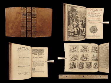
1699 Jean Dumont VOYAGES in France Italy Germany ROME Malta Turkey Ottoman 3vSchilb Antiquarian Rare Books4.8(421)See Sold PriceMar 31, 2024
Cooke, George 1801 Antique Map. Italy, Sicily, Sardinia & CorsicaAlbion Auctions4.6(336)See Sold PriceMar 01, 2024
Blackie (Pub) 1882 Pair of Folio Maps. Italy - North & SouthAlbion Auctions4.6(336)See Sold PriceMar 01, 2024
ILLUSTRATED ANCIENT ROMAN CHURCH HISTORY FRANCE ITALY GERMANY SWITZERLAND 1700NY Elizabeth 4.3(84)See Sold PriceMar 03, 2024
Carl Johan Billmark - Set of 4 Prints depicting Rome, Italy - Church in Sweden - Views of EuropeProverde Auctions4.3(3)See Sold PriceFeb 28, 2024
Joseph Meyer - Set of 50 Prints - Views of Austria - Germany - Italy - Sweden - France - CzechProverde Auctions4.3(3)See Sold PriceFeb 28, 2024
Joseph Meyer - Set of 50 Prints - Views of Austria - Germany - Italy - Sweden - France - UnitedProverde Auctions4.3(3)See Sold PriceFeb 28, 2024
Joseph Meyer - Set of 20 Prints - Views of Austria - Germany - Italy - Switzerland - France - SpainProverde Auctions4.3(3)See Sold PriceFeb 28, 2024
Disney Magic Mediterranean Cruise 2007 Map W CoinsRapid Estate Liquidators and Auction Gallery4.5(1.1k)See Sold PriceMar 01, 2024
Antique Map of France, 1703 by Gillaume Del Isle PrintAntiques Online Auctions4.6(407)See Sold PriceMar 14, 2024
The Last Coins of Europe 12 Coins Set - Spain, Portugal, France, Italy, Ireland, Belgium, Luxemburg,Andrew's Coin & Jewelry4.5(209)See Sold PriceMar 07, 2024


![Various Maps [France, Italy, Switzerland, Turkey] (1 of 12)](https://p1.liveauctioneers.com/5755/157962/79722188_1_x.jpg?height=282&quality=70&version=1576875253)

![Pedemontana Regio Map [France, Italy Map] (1 of 4)](https://p1.liveauctioneers.com/5755/154409/77936956_1_x.jpg?height=282&quality=70&version=1573094011)