SoldMAP CARRIBEAN & GULF OF MEXICO, C. 1777, V. ROSSIFramed map of the West Indies, the Carribbean and Gulf of Mexico, c. 1763-1777, titled in Italian "Nuova c corretta Carta dell Indie Occidentali cavata dalle migliori autorita", engraved by D. VeremonSee Sold Price
Soldc1777 Map of the Gulf of Mexico by Thomas Kitchinc1777 Map of the Gulf of Mexico by Thomas Kitchin A very attractive hand coloured map of the Gulf of Mexico by Thomas Kitchin, which has been mounted, framed and glazed. The full title is ‘MAP OF THSee Sold Price
SoldMark Catesby, "Map of the Gulf of Mexico," 20th c.Mark Catesby, "Map of the Gulf of Mexico," 20th c., after the 1731 original, presented in an antique mahogany frame with faux bois sides, H.- 19 1/2 in., W.- 27 1/4 in.See Sold Price
MAP, Gulf of Mexico & Caribbean, VisscherGulf of Mexico & Caribbean. Nicolas Visscher, Insulae Americanae in Oceano Septentrionali ac Regiones Adiacentes, a C. de May usque ad Lineam Aequinoctialem, 1708 (circa). Hand Color. This handsome maSee Sold Price
SoldWytfliet Map of Gulf of Mexico, 1597WYTFLIET, Cornelis (c. 1550-1597). Florida et Apalche. Engraved map. Louvain, 1597-1603. 11 3/4” x 14” sheet. Highly important map of the Southeast and Gulf Coast of North America, from the Rio EsSee Sold Price
Sold3 Items: Partie des Etats_Unis + 2 Maps.[Carribean/Bermuda/Gulf of Mexico]. 3 Items. Early hand-colored outline. ++ Partie Des Etats_Unis. Consists of 2 columns of French text, with a small lithographed map of northeastern North Carolina atSee Sold Price
SoldAntique French Buache map of the Carribean and GulfAntique French JN Buache map of the Gulf of Mexico, Caribbean, Antilles and West Indies. Sight size 19 3/4"h x 36 3/4" w Framed size 28"h x 45"wSee Sold Price
SoldKeulen Gulf of Mexico MapPas Kaart van de Golff van Mexico. Gerard van Keulen (1678–1726). Copperplate Engraving. Amsterdam, c. 1734. Fourth State. 21 1/4 x 24 inches sheet. Gerard Van Keulen's map of the Gulf Coast is a laSee Sold Price
Map of America, together with the Gulf of Mexico. 1847.Map of West - India and Centro - America, together with the Gulf of Mexico. 1847. Print of steel engraving, hand colored titled „West Indien und Centro America nebst dem Meerbusen v. Mexico.Author JSee Sold Price
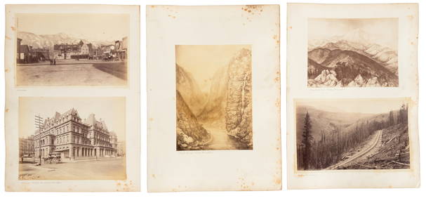
Sold[CARRIBEAN AND SOUTH AMERICA]. 6 mapsCaribbean and South America. Lot of 6 maps, including: Kitchin, Thomas. The Gulf of Mexico. Islands andCountries adjacent. For the Rev. Dr. Robertson's History of America. London: T. Cadell; J. CrofsSee Sold Price
Seutter Map of Mexico Southern US & Gulf 1700sMappa Geographica Regionem Mexicanam et Floridam. By Matthaeus Seutter. Hand-colored copper plate engraving, circa early 18th c. 20 x 24" plate size. Some tears at bottom and a few other margins.See Sold Price
Mexico.- Sanson (Nicolas) Mexicque, ou Nouvelle EsMexico.- Sanson (Nicolas) Mexicque, ou Nouvelle Espagne, Nouvlle. Gallice, Iucatan &c ...,map showing most of Mexico through the Gulf of Panama and including parts of Cuba and Florida, decoratSee Sold Price
Gulf of Mexico, West Indies and Caribbean Sea. from theReserve Reduced! Title: Gulf of Mexico, West Indies and Caribbean Sea. from the Most Recent Spanish and British Admiralty Charts. Sheet V. Publication Date: 1870-07-01 Cartographer: ANONYMOUS PublisheSee Sold Price
Gulf of Mexico, West Indies and Caribbean Sea. from theTitle: Gulf of Mexico, West Indies and Caribbean Sea. from the Most Recent Spanish and British Admiralty Charts. Sheet V. Publication Date: 1870-07-01 Publisher: U.S. NAVY. HYDROGRAPHIC OFFICE Size: 2See Sold Price
Gulf of Mexico, West Indies and Caribbean Sea. from the Most Recent Spanish and British AdmiraltyPublication Date: 1870-07-01 Title: Gulf of Mexico, West Indies and Caribbean Sea. from the Most Recent Spanish and British Admiralty Charts. Sheet V. Cartographer: ANONYMOUS Publisher: U.S. NAVY. HYDSee Sold Price
Gulf of Mexico, West Indies and Caribbean Sea. from theTitle: Gulf of Mexico, West Indies and Caribbean Sea. from the Most Recent Spanish and British Admiralty Charts. Sheet V. Publication Date: 1870-07-01 Cartographer: ANONYMOUS Publisher: U.S. NAVY. HYDSee Sold Price
Gulf of Mexico, West Indies and Caribbean Sea. from theTitle: Gulf of Mexico, West Indies and Caribbean Sea. from the Most Recent Spanish and British Admiralty Charts. Sheet V. Cartographer: ANONYMOUS Publisher: U.S. NAVY. HYDROGRAPHIC OFFICE Height: 23.8See Sold Price
Vereinigte Staaten Von Nord-America Und Mexico.Title/Content of Map: Vereinigte Staaten Von Nord-America Und Mexico. Date: 1857 Cartographer: RADEFELD, C.C.F. Size: 7.5X10 "Entw. u. gez. v. Major Radefeld." From the "Neues Conversations Lexicon."See Sold Price
Oil map of eastern MexicoHeading: (Mexico - Oil Map) Author: Title: Mexican Gulf Oil Co. General Map of Topila District Place Published: No place Publisher: Date Published: c.1930? Description: BluSee Sold Price
Oil map of eastern MexicoHeading: (Mexico - Oil Map) Author: Title: Mexican Gulf Oil Co. General Map of Topila District Place Published: No place Publisher: Date Published: c.1930? Description: BluSee Sold Price
Vereinigte Staaten Von Nord-America Und Mexico.Title: Vereinigte Staaten Von Nord-America Und Mexico. Publication Date: 1857 Cartographer: RADEFELD, C.C.F. Publisher: BIBLIOGRAPH. INSTITUT Size: 7.5Height - 10Width Entw. u. gez. v. Major Radefeld.See Sold Price
SoldColonies Francaises en Amerique sheet of 6 maps.[Carribean]. Colonies Francaises En Amerique. 6 maps on one double plate, engraved by Erhard. Paris: V. A. Malte-Brun/ A. H. Dufour Geographie, n.d. From ''Atlas France Illustree,'' c.1880. 9 1/2 x 13See Sold Price
SoldMexico with semi-autonomous Texas, c.1837Heading: Author: Monin, Charles V. Title: Republique des États Unis du Mexique Place Published: Paris Publisher:Armand Aubrée Date Published: c.1837 Description: Copper-engravedSee Sold Price
SoldBellin: Antique Map Gulf of Mexico & West Indies, 1754Title/Content of Map: Carte du Golphe de Mexique et des Isles de l'Amerique Cartographer: Jacques Bellin Place & Date: Paris / 1754/1760 Size: 14 3/4" x 10 3/4" Condition: b&w; old folds as published;See Sold Price
EARLY 18TH C. MAP OF ITALY, FRAMEDThomaston Place Auction Galleries4.4(386)See Sold PriceFeb 24, 2024
LATE 16TH C. MAP OF SCOTLAND BY MERCATOR, FRAMEDThomaston Place Auction Galleries4.4(386)See Sold PriceFeb 24, 2024
17TH C. MAP OF THE BERKSHIRES BY JOHN SPEED, FRAMEDThomaston Place Auction Galleries4.4(386)See Sold PriceFeb 24, 2024
VERACRUZ CULTURE, GULF COAST MEXICO, C. 550-950 AD, FLUTEThomaston Place Auction Galleries4.4(386)See Sold PriceFeb 24, 2024
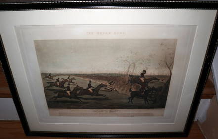
HENRY ALKEN / LEWIS Original 1835 Hand Colored Engraving Quron Hunt Snob Is BeatLuis Porretta Fine Arts4.3(10)See Sold PriceMar 02, 2024
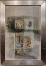
Luis Toledo O/B Modernist Abstract Painting 1970 ESTRATOSHeritage Gallery Auctions4.4(56)See Sold PriceMar 10, 2024
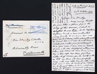
WWI KING EDWARD VIII LETTER TO ADM SIR STANLEY COLVILLEOmnia Auctions4.7(324)See Sold PriceFeb 26, 2024
Eight Gulf, Mobile & Ohio Railroad Playing Card Decks - Alton Route Map and LogoRail & Road Auctions4.6(165)See Sold PriceMar 08, 2024
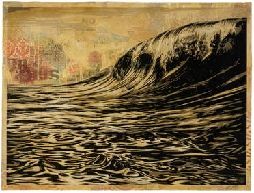
Shepard Fairey (b. 1970), "Dark Wave," 2010, Screenprint, collage, and hand-painted (HPM) on paper,John Moran Auctioneers, Inc.4.7(453)See Sold PriceFeb 27, 2024
Johann Homann Hand-Colored Map Engraving, c. 1730Auctions at Showplace4.5(726)See Sold PriceMar 17, 2024
1816 MAP NORTHERN PART OF RUSSIA or MUSCOVY in EUROPE copper engraving ANTIQUEJasper524.5(9.8k)See Sold PriceFeb 27, 2024
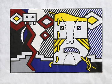
Roy Lichtenstein "American Indian Theme V (C. 164)" 1980 Woodcut on Handmade Suzuki Paper, signed anWhite Knight Auction, Inc4.7(248)See Sold PriceFeb 25, 2024
Roy Lichtenstein "American Indian Theme V (C. 164)" 1980 Woodcut on Handmade Suzuki Paper, signedJoshua Kodner4.2(386)See Sold PriceMar 09, 2024


![[CARRIBEAN AND SOUTH AMERICA]. 6 maps (1 of 2)](https://p1.liveauctioneers.com/1124/187577/94368856_1_x.jpg?height=282&quality=70&version=1607095126)