ATLAS of ANTIENT GEOGRAPHY by SAMUEL BUTLER 1843John McInnis Auctioneers,LLC4.6(504)See Sold PriceFeb 24, 2024
18TH C. ANTIQUE MAP: FRENCH & INDIAN WAR, FRAMEDThomaston Place Auction Galleries4.4(389)See Sold PriceFeb 24, 2024
Rand McNally Railroad Map Cabinet w/ 21 Railroad MapsRail & Road Auctions4.6(165)See Sold PriceMar 08, 2024
Keith Haring - Ink on New York Map, Best Buddies, Inscribed, Signed, and DatedSapphire Auction Gallery4.1(67)See Sold PriceMar 02, 2024
LATE 17TH C. FRENCH MAP OF THE NEW WORLD BY ALEXIS-HUBERT JAILLOT (1632-1712)Thomaston Place Auction Galleries4.4(389)See Sold PriceFeb 24, 2024
Central Railroad of New Jersey Map of Sandy Hook Route-ca. 1903JM Hobby Supply and Railroad Artifact Auctions4.4(126)See Sold PriceFeb 24, 2024
Lot of Six Mixed Atlas Box Cars-HO Scale-New in BoxJM Hobby Supply and Railroad Artifact Auctions4.4(126)See Sold PriceFeb 25, 2024
Rand McNally/Santa Fe Railroad Map of Iowa-1912JM Hobby Supply and Railroad Artifact Auctions4.4(126)See Sold PriceFeb 24, 2024
NICOLAES VISSCHER (NETHERLANDS, 1618-1709) MAP OF THE NEW WORLDThomaston Place Auction Galleries4.4(389)See Sold PriceFeb 24, 2024
17TH C. WORLD MAP BY NICOLAES VISSCHER (NETHERLANDS, 1618-1709)Thomaston Place Auction Galleries4.4(389)See Sold PriceFeb 24, 2024
Lot of Six Mixed Atlas Cabooses-HO Scale-New in BoxJM Hobby Supply and Railroad Artifact Auctions4.4(126)See Sold PriceFeb 25, 2024
MAP, Caribbean & Bermuda, Homann HeirsCaribbean & Bermuda. Homann Heirs, Dominia Anglorum in Praecipuis Insulis Americae ut sunt Insula S. Christophori Antego Iamaica Barbados nec non Insulae Bermudos vel Sommers…, from Atlas GeographicSee Sold Price
MAP - Caribbean & Bermuda. Homann HeirsCaribbean & Bermuda. Homann Heirs, Dominia Anglorum in Praecipuis Insulis Americae ut sunt Insula S. Christophori Antegoa Iamaica Barbados nec non Insulae Bermudes vel Sommers…, 1759 (circa). HaSee Sold Price
SoldHomann Heirs: British Caribbean and Atlantic IslandsDominia Anglorum in praecipuis Insulis Americae On one sheet, five highly detailed maps of British possessions in the Caribbean and Atlantic: St. Kitts, Antigua, Bermuda, Barbados, and Jamaica. St. KiSee Sold Price
SoldVarious. 2 maps of the West Indies. c.1740/1817.[Caribbean] 2 maps. (1) Homann Heirs. Dominia Anglorum in Praecipuis Insulis Americae ut sunt Insula S. Christophori Antegoa Iamaica Barbados nec non Insulae Bermudes vel Sommers. c.1740. Engraved mapSee Sold Price
SoldVarious. 2 maps of the West Indies. c.1740/1817.[Caribbean] 2 maps. (1) Homann Heirs. “Dominia Anglorum in Praecipuis Insulis Americae ut sunt Insula S. Christophori Antegoa Iamaica Barbados nec non Insulae Bermudes vel Sommers.” c.1740See Sold Price
SoldCaribbean.- Homann Heirs (publishers) Carte de l'IsleCaribbean.- Homann Heirs (publishers) Carte de l'Isle de la Martinique dressée par Mr. Bellin..., German edition, engraving with hand-colouring on laid paper with watermark of initials and key, sSee Sold Price
SoldCaribbean.- Homann (Johann Baptist) Dominia Anglorum inCaribbean.- Homann & Heirs (Johann Baptist) Dominia Anglorum in praecipuis Insulis Americae ut sunt Insula S. Christopheri, Antegoa, Jamaica, Barbados nec non Insula Bermudes vel Sommers dictae..., fiSee Sold Price
Sold1740 Mappa Geographica, complectens I. IndiaeThis is an authentic antique map of the Caribbean with several smaller inserts surrounding, by Homann Heirs. The map was published in Nuremberg circa 1740. This handsom copper-plate engraving focusesSee Sold Price
SoldHomann Heirs: Antique Composite Map of West Indies 1740Map: Mappa Geographicae, complectens Indiae Occidentalis/ Carte des Isles de l'Amerique Cartographer: Homann Heirs/J.B.B. d'Anville Place & Date: Nurnberg / 1740 Size: 19" x 22 5/8" Condition: Main WeSee Sold Price
Homann Heirs/ d’Anville: West Indies Antique Map, 1740Map: Mappa Geographicae, complectens Indiae Occidentalis/ Carte des Isles de l'Amerique Cartographer: Homann Heirs/J.B.B. d'Anville Place & Date: Nurnberg / 1740 Size: 19" x 22 5/8" Condition: Main WeSee Sold Price
SoldHomann Heirs: Antique Map of British West Indies, 1740Map: Dominia Anglorum in praecipuis Insulis Americae Cartographer: Homann Heirs Place & Date: Nuremberg / 1740 Size: 22" x 19 1/4" Condition: outline color; overall age toning; repaired splits at centSee Sold Price
SoldHomann Heirs Map of the West Indies and Mexico 17Homann Heirs, "Mappa Geographica complectens I. Indiae Occidentalis Partem Mediam Circum Isthmum Panamensem," Nuremberg, 1740. Hand colored map of the Gulf Coast, Florida, and the Caribbean, with inseSee Sold Price
SoldHomann (Heirs of) Insulis AmericaeHomann (Heirs of) Insulis AmericaeIslands of St. Christopher, Antigua, Jamaica, Barbados, and Bermuda, large title cartouche in Latin and German (uncoloured), 5 engraved maps on one sheet withSee Sold Price
Homann (Heirs of) Dominia Anglorum in præcipuis InHomann (Heirs of) Dominia Anglorum in præcipuis Insulis Americæ,5 maps on 1 sheet of St Kitts, Antigua, Bermuda, Barbados and Jamaica, each with compass rose, title cartouche, in Latin and GerSee Sold Price
SoldHomann (Heirs of) West IndiesHomann (Heirs of) Dominia Anglorum in præcipuis Insulis Americæ,5 maps on 1 sheet of St Kitts, Antigua, Bermuda, Barbados and Jamaica, each with compass rose, title cartouche, in Latin and GerSee Sold Price
SoldHomann (Heirs of) West IndiesHomann (Heirs of) Dominia Anglorum in præcipuis Insulis Americæ,5 maps on 1 sheet of St Kitts, Antigua, Bermuda, Barbados and Jamaica, each with compass rose, title cartouche, in Latin and GerSee Sold Price
SoldHomann: British West Indies/Atlantic Islands Map, 1740Map: Dominia Anglorum. British West Indies/Atlantic islands of St Christopher (St Kitts), Antigua, Bermuda, Jamaica & Barbados Date Printed: c1740 Image Size: Approx 52.5 x 59.5cm, 20.5 x 23.25 inchesSee Sold Price
SoldMap : Homann Heirs Americae Mappa Generalis SecundumMap : Homann Heirs Americae Mappa Generalis Secundum Legitimas Projectionis a hand coloured map of the Americas published Nuremburg 1746, with cartouche to bottom left, framed and glazed.See Sold Price
Sold(MAP) HOMANN HEIRS, after. Regnum Bosniae...(MAP) HOMANN HEIRS Regnum Bosniae, una cum finitimis Croatiae, Dlmatiae, Slavoniae, Hung. et Serviae, partibus, adjuncta praecipuorum in his regionibus munimentorum ichnographia. (Nuremberg, c. 1738).See Sold Price
SoldMap, Homann HeirsHomann Heirs (German, 1664-1724), "Ingermanlandiae seu Ingriae Novissima Tabula Luci Tradita," 1740, hand-colored engraving, image (sight): 19.25"h x 23"w, overall (with mat/unframed): 26"h x 30"w. PrSee Sold Price
SoldCopper Engraved Map, Homann HeirsHomann Heirs (German, 1724-1848), "Dominia Anglorum in America Septentrionali/Sie Gros-Brittanische Colonie Laender in Nord-American," circa 1740, 4 copper engraved maps on one sheet with hand colorinSee Sold Price
Sold1 piece. Hand-Colored Engraved Map. Homann Heirs.1 piece. Hand-Colored Engraved Map. Homann Heirs. Mappa Geographica Regni Poloniae." Nuremberg, 1750. 18 3/4 x 21 3/8 inches; 476 x 542 mm. Later color? Slightly dusty. Framed."See Sold Price
SoldMAP -- Homann Heirs. Dominia Anglorum in AmericaMAP -- Homann Heirs. Dominia Anglorum in America Septentrionali.Nuremberg: c. 1750. Double-page engraved map, hand-colored (515 x 570 mm). Four maps on one sheet, depicting Newfoundland, NewSee Sold Price
RARE MAP - Homann Heirs (company): "Mappa geographicaRARE MAP - Homann Heirs (company): "Mappa geographica complectens, I. Indiae occidentalem, II. Isthmum Panamensem, III. Ichnographiam præcipuorum locorum & portuum ad has terras pertinentium : DesuSee Sold Price
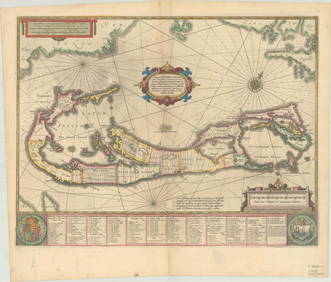
RARE 1638 HONDIUS MAP OF BERMUDA, FRAMEDThomaston Place Auction Galleries4.4(389)See Sold PriceFeb 24, 2024
1736 LARGE MAP OF SILESIA POLAND OPPAVIENSIS antique 25 by 34 3/4"Jasper524.5(9.8k)See Sold PriceFeb 27, 2024
1736 LARGE MAP OF SILESIA POLAND KARNOVIENSIS antique 25 x 4 3/4" Duchy of KrnovJasper524.5(9.8k)See Sold PriceFeb 27, 2024
1750 Bowen Map of Bermuda and St. Kitts -- A New & Accurate Map of Bermudas or Sommer's Islands...Jasper524.5(9.8k)See Sold PriceFeb 27, 2024