Sold(MAP) BLAEU, W. & J.Virginiae partis australis... [(MAP) BLAEU, W. & J. Virginiae partis australis, et Floridae partis orientalis, interjacentiumq, regionum Nova Descriptio. [Amsterdam, c. 1640 or later] Hand-colored engraved map of the east coast. FrSee Sold Price
SoldTwo engraved and hand-colored maps of Egypt1) J. Jansson; "Aegypti Recentior Descriptio …" (Amsterdam: 1666) about 16 X 20 in., p.m.; 2) J. Blaeu, "Nova Aegypti Tabula" circa 1670, about 17 1/4 X 20 1/2 in., p.m.; Property from the Hans GoedSee Sold Price
SoldScenes of Europe engravings, 19th c.Group of 4 hand colored steel engravings of scenes of Europe. 19th c. ++ J. C. Varrall after W. J. Cooke. 'Amsterdam van het IJ gezien.' (Amsterdam, The Netherlands, view from the IJ-lake). From "HetSee Sold Price
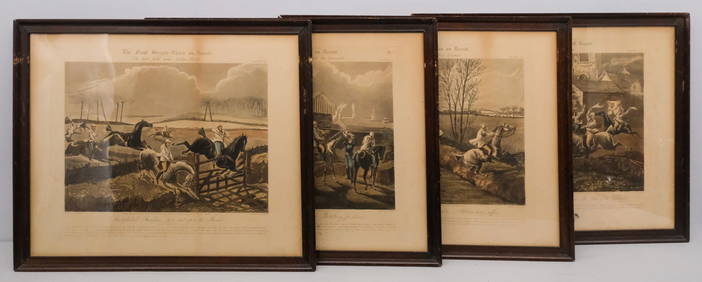
SoldEnglish School (19th Century), Group of Four Rabbitinghand-colored prints mounted to panel, one signed "ColD J. W. Sr.," housed in uniform gilt frames. DOA 7 1/4 x 9 1/2 in. This suite once hung in the main salon of the "Maggie Fury," an auxiliary yawl dSee Sold Price
Sold3 18th C. maps incl. R. Vaugondy and J. BaylyItem 1: Robert de Vaugondy hand colored map "Amerique septen trionale." French, 1750. 6 3/8" H x 6 1/2" W. Item 2: Robert de Vaugondy hand colored map "Mappe Monde" French, 1750. 6 3/8" H x 12 1/8" W.See Sold Price
SoldThree Maps of A. J. Johnson's , "Venetia, Kingdom ofThree Maps of A. J. Johnson's , "Venetia, Kingdom of Italy," 1863, hand colored, H.- 26 1/2 in., W.- 18 in. Italy, 1863 (3 Pcs.)See Sold Price
SoldTwo Maps by A. J. Johnson, "Africa," 1864, handTwo Maps by A. J. Johnson, "Africa," 1864, hand colored, H.- 26 1/2 in., W.- 18 in. (2 Pcs.)See Sold Price
Sold1855 Map of Georgetown and the City of Washington by J.H. ColtonColton's Georgetown and the city of Washington: the capital of the United States of America. Issued in 1855 by J. H. Colton (1800-1893). Hand colored. Frame size: 20 1/2" H x 24 3/4" W x 1 1/8" D. SigSee Sold Price
SoldGroup of Early 19th Century Celestial Mapshand-colored engravings by W. G. Evans of New York, under the direction of editor E. H. Burritt. published 1835, Hartford, Connecticut by F. J. Huntington in the “Atlas of the Heavens”. the atlasSee Sold Price
Sold2 Antique MapsOne hand-colored engraving Hambourg? J. Covens & C. Mortier, approx. 18" H x 22" W sight, 24" H x 27" W framed. One hand-colored engraving, "Nova Anglia." Johann B. Homann, approx. 21" H x 25" W sightSee Sold Price
SoldATTRIBUTED TO WILLEN BLAEU 2 ENGRAVED MAPSATTRIBUTED TO WILLEN BLAEU, 2 HAND COLORED ENGRAVED MAPS, "NAVA BELGICA" & "MAPPA AESTIVARUM", 15 1/4" X 19 3/4" & 16" X 21" DATES OF PRINTING ARE UNKNOWN; FRAMED. ARNOLD KLEIN FRAMING LABEL.See Sold Price
SoldFramed large antique map of Ireland by W. Blaeu.Framed large antique map of Ireland by W. Blaeu. Hand-colored copper plate engraving. Published in Amersterdam, 1635. Measures 16.5" w x 20.5". Originally purchased at Jonathan Potter, LTD., London. BSee Sold Price
SoldHand Colored and Engraved Map - Portugallia et AlgarbiaBLAEU, W. Hand colored, engraved and printed map. Portugallia et Algarbia quae olim Lusitania. After the original prepared by Fernando Alvarez Secco, a Portuguese map maker who's map was used by varioSee Sold Price
SoldMaps, Blaeuw, Schenk, Flandriae(Lot of 6) Framed 16th-18th century hand-colored copper engraved maps including: ''Marcha Anconae,'' 1572; ''Germaniae Inferiors,'' 1704, by P. Schenk; ''Corsica,'' 16th century; ''Pictov/Pictonum VicSee Sold Price
SoldBlaeu, W., Map - "Polonia Begnum et...""Polonia Regnum et Silesia Ducatus". Engraved and hand-colored map on laid paper. Amsterdam 1630. Depicts Poland with two cartouches and two coat of arms surmounted by cherubs and female figures. [MapSee Sold Price
Sold(2) ATLAS MINIMUS MAP PAGES, J. GIBSON & E. BOWEN(lot of 2) Framed hand colored pages from the Atlas Minimus by John Gibson (British, 1750-1792) and improved by Emanuel Bowen (English, 1694?-1767), comprising: (1) "Turky in Asia", plate 30; (1) "EgySee Sold Price
Sold2 Hand Colored Maps - Florida & AlabamaTwo Gray's Atlas Maps on one sheet - Florida & Alabama Depicts railroad lines, common roads, canals, topography, etc. Maps are on each side of one sheet. A beautiful & rarSee Sold Price
SoldLot of 2 J.J. Audubon ornithological engravingsLot of 2 J.J. Audubon hand colored ornithological engravings depicting American Sparrow Hawk and Boat tailed Grackle. Engraved & coloured by R. Havell, London. 37 3/4"h x 26 3/4"wSee Sold Price
Sold(RAILROAD.) Northern Pacific Railroad. MemoriaWITH A LARGE FOLDING MAP BY COLTON. (RAILROAD.) Northern Pacific Railroad. Memorial of the Board of Direction of the Company [wrapper title]. Large 2-sheet hand-colored folding map by G. W. & C. B. CSee Sold Price
Sold(2) HAND COLORED JOHN GOULD LITHOGRAPHS2 Lithographs from John Gould Birds of Paradise folio, J.Gould Chlamydodera Cerviniventris "W. Hart del et Lith" Mintern Bros Imp. and Chyamydodera Nuchalis Jard & Selby. Hand colored. Measures 22.5"See Sold Price
Sold(MAP) VISSCHER, NICOLAUS. A group of 2 maps, 1678.(MAP) VISSCHER, NICOLAUS A group of two hand-colored engraved maps, [Amsterdam, c. 1678] Magnae Britanniae Tabula, with engraved cartouche featuring Hercules slaying cerebus to the right and an armoriSee Sold Price
Sold(1635) Blaeu Map: Mappa Aestivarvm Insularum,...Historic Maps Hand-Colored "Mappa Aestivarvm Insularum, alias Barmvdas dictarum..." by Willem J. Blaeu, Amsterdam (1635) Hand-Colored Historic Dutch Map titled: "Mappa Aestivarvm Insularum, alias BarmSee Sold Price
Northern France 1647Map Title: Picardia Regio Belgica Published: Blaeu, W. & J., Amsterdam Date: 1647 Size: 15 x 21 inches Richly colored map of Picardy in Northern France along the Somme River, with a Charming CartoucheSee Sold Price
SoldColton: Antique Map of South America, 1861Title/Content of Map: South America Date Printed: 1861 Cartographer: J.H. Colton Material/Medium: Paper Size: 14" x 17 1/2" Hand colored steel engraved Map from 'Colton's General Atlas'. Published inSee Sold Price
MARTINET / DE VRIES Catechism of Nature 4 Vol. Set c1788 Engravings Rare!Luis Porretta Fine Arts4.3(10)See Sold PriceMar 02, 2024
BOTH TITLE PAGES OF COLLINS" COASTAL SURVEY, 1776, IN MATCHING FRAMESThomaston Place Auction Galleries4.4(393)See Sold PriceFeb 24, 2024
ABRAHAM ORTELIUS (1527-1598) MAP OF ROMAN GAUL (FRANCE)Thomaston Place Auction Galleries4.4(393)See Sold PriceFeb 24, 2024
Willem Blaeu, Etc. 17th C. Antiquarian Maps, 2Auctions at Showplace4.6(740)See Sold PriceMar 17, 2024
Albin - Bald or Vulturine Eagle. 2-3Trillium Antique Prints & Rare Books4.5(32)See Sold PriceFeb 24, 2024
Albin - King Vulture or Warwounen. 2-4Trillium Antique Prints & Rare Books4.5(32)See Sold PriceFeb 24, 2024
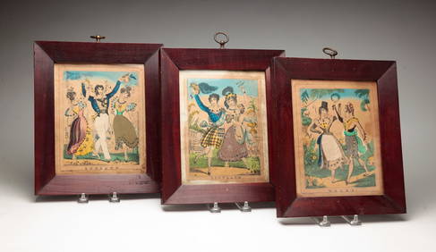
THREE HAND COLORED AND ADORNED PRINTS.Amelia Jeffers, Auctioneers & Appraisers4.5(120)See Sold PriceMar 08, 2024
After H. Alken, Group of 4 Steeplechase PrintsOld Kinderhook Auction Company4.6(217)See Sold PriceMar 05, 2024
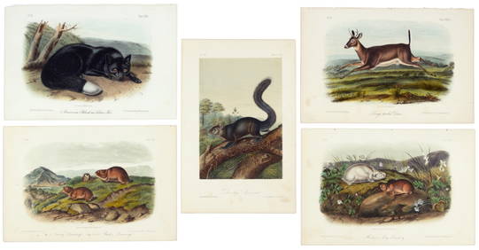
First 50 plates from Audubon's Quad Quarto (all in Vol. I)PBA Galleries4.7(385)See Sold PriceMar 07, 2024
Nearly complete set of plates from Vol. III Quad QuartoPBA Galleries4.7(385)See Sold PriceMar 07, 2024
Two Hand-Colored 19th Century Maps of New Orleans and Louisiana, Larger- H.- 12 1/2 in., W.- 15 1/2Crescent City Auction Gallery4.3(231)See Sold PriceMar 08, 2024
1849 Orr & Co. Hand Colored Southern Germany MapMatthew Bullock Auctioneers4.7(1.8k)See Sold PriceMar 02, 2024