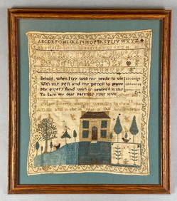
(18th c) SAMPLER by SARAH BROWN born 1780.John McInnis Auctioneers,LLC4.6(504)See Sold PriceFeb 25, 2024
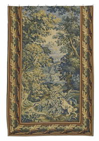
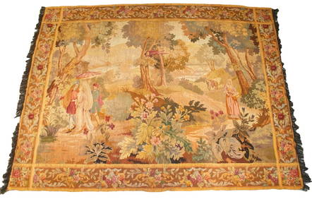
FRENCH WOVEN VERDURE WOODED LANDSCAPE TAPESTRYAustin Auction Gallery4.7(1.2k)See Sold PriceFeb 25, 2024
Antique American Hooked Rug Dog Portrait Textile TapestryCurated Gallery Auctions4.6(128)See Sold PriceFeb 25, 2024
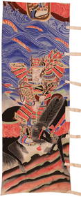
Antique very long Chinese embroidery on silk using golden thread, familial scenes with dragon, goodNeely Auction4.6(224)See Sold PriceFeb 25, 2024
1811 36th Year of Independence Mary Gilbert American Needlepoint SamplerMatthew Bullock Auctioneers4.7(1.8k)See Sold PriceMar 02, 2024
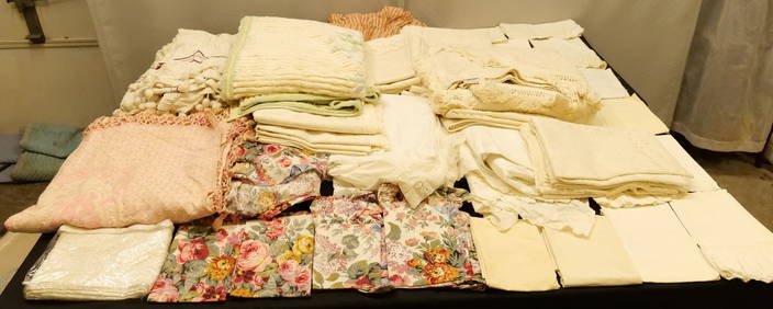
An Assorted Group of Seventeen Chinese Textiles and Textile FragmentsNazmiyal Auctions4.4(34)See Sold PriceFeb 26, 2024
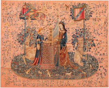
No Reserve Early 20th Century French Unicorn Design Tapestry 5 ft 9 in x 4 ft 8 in (1.75 m x 1.42 m)Nazmiyal Auctions4.4(34)See Sold PriceFeb 25, 2024
Visscher Map of AustriaAustriae Archiducatus Pars Inferior. Claes J. Visscher (1587-1652). Engraved map with original color in full. Amsterdam, 1705. 21 x 25 inches sheetSee Sold Price
Visscher Map of Austria Showing SalzburgVISSCHER, Nicolas II (1649-1702). Austriae Archiducatus Pars Superior... Engraving with original hand color. Amsterdam, 1683-1696 (Atlas Minor). Approx. 21 1/2" x 24 1/4" sheet. Antique Map of AustriaSee Sold Price
Visscher map of northern AustriaHeading: Author: Visscher, Nicholas Title: Austriae Archiducatus pars Superior Place Published: Amsterdam Publisher: Date Published: c.1680 Description: Copper-engraved mapSee Sold Price
SoldOriginal 1944 WWII Allied Bombing Map - AustriaThis is a very rare, original vintage WWII allied air crew bombing run target chart for "Vienna/Lobau Oil Blending Plt, Austria," dated May, 1944. States "Prepared Under the Direction of IntelligenceSee Sold Price
Sold(MAP) VISSCHER, NICOLAUS. A group of 2 maps, 1678.(MAP) VISSCHER, NICOLAUS A group of two hand-colored engraved maps, [Amsterdam, c. 1678] Magnae Britanniae Tabula, with engraved cartouche featuring Hercules slaying cerebus to the right and an armoriSee Sold Price
SoldTallis, John (Pub) 1852 Map. AustriaSteel Engraved Map with Original Outline Hand Color Published 1852-56 by John Tallis, London for "The Universal Pronouncing Dictionary" by Thomas Wright. Drawn & Engraved by John Rapkin. Centre fold aSee Sold Price
Sold(MAP) VISSCHER, NICOLAUS. [Amsterdam, c. 1690](MAP) VISSCHER, NICOLAUS Tabula nova Provinciae Ultrajectinae, [Amsterdam, c. 1690] Hand-colored engraved map showing the areas between Amsterdam, Gouda, Arnheim and Zutphen, including Utrecht and AmeSee Sold Price
SoldAntique Engraved map, VisscherFramed antique engraved map, ''Insulae Americanae in Oceano Septentrionali ac Regiones Adiacentes...Westfrisiae'', by Nicolaes Visscher, Condition: some tears, some paper loss, overall: 28'' x 32'' 18See Sold Price
Sold1 piece. Hand-Colored Engraved Map. Visscher, Nic1 piece. Hand-Colored Engraved Map. Visscher, Nicholas. Insulae Americanae in Oceano Septentrionali." [Amsterdam], [1698]. 18 1/8 x 22 1/2 inches; 460 x 572 mm, narrow margins. Slightly toned, minor sSee Sold Price
SoldMap, Visscher, Novi Belgii, Nieuw AmsterdamFramed copper engraved handocolored map, ''Novi Belgii novaeque Angliae nec non partis Virginiae Tabula,'' by Nicholas Visscher II (Dutch, 1683-1696), sight: 17.125''h x 21''w, overall: 19''h x 23''wSee Sold Price
SoldJoshua Neustein (b. 1940) Steel Map, Austria withJoshua Neustein (b. 1940) Steel Map, Austria with Echoes of Northern Borders, 1994, Etched steel, Signed, titled and dated on verso. Dimensions: h: 48 x w: 35 1/2 in.Provenance: MOCA, Cleveland. PurchSee Sold Price
SoldHAND COLORED MAP AUSTRIA ARCHDUCATIS DATED 1585By Gerardus Mercator dated ca. 1585. Map measures 7 1/2" wide x 6" tall and framed is 12 1/2" wide x 10" tall. Some foxing to print. Good condition.See Sold Price
SoldJohann Baptist Homann, Engraved Map - AustriaHand painted map titled: "Prospect Undgrund-Riss der Kayserl Residenz..." Bird's-eye plan of old Vienna and its fortifications and the surrounding environs. Features a panoramic view below. Dated 1740See Sold Price
SoldLot of 3 maps- Austria, Hungary, PolandCartographers: Conrad Mannert, Karl Mller, Daniel Friedrich Sotzmann Title: [Map 1, Conrad Mannert] Charte vom Erzherzogthum Oesterreich den Herzogthmern Steyermark, Salzburg, K„rnthen und Krain [inSee Sold Price
Sold1 piece. Hand-Colored Engraved Map. Visscher, Nic1 piece. Hand-Colored Engraved Map. Visscher, Nicolaes. Portugalliae et Algarbiae Regna." [Amsterdam], [1698]. 18 1/2 x 22 1/2 inches; 470 x 570 mm, margins. Slightly age toned., scattered light foxinSee Sold Price
Johnson's Map - Austria Turkey in Europe & Greece, 1861**Originally Listed At $100** "Johnson's Austria Turkey In Europe and Greece" by Johnson & Browning, with inset map of Candia, ca. 1860. Published in Johnson's New Illustrated (steel plate) Family AtlSee Sold Price
Johnson's Map - Austria Turkey in Europe & Greece, 1861**First Time At Auction** "Johnson's Austria Turkey In Europe and Greece" by Johnson & Browning, with inset map of Candia, ca. 1860. Published in Johnson's New Illustrated (steel plate) Family Atlas,See Sold Price
Sold1 piece. Hand-Colored Engraved Map. Visscher, Nic1 piece. Hand-Colored Engraved Map. Visscher, Nicolaes. Leodiensis Episcopatus in Omnes Subjacentes Provincias." [Amsterdam], [ca. 1680]. 18 1/2 x 22 1/2 inches (470 x 570 mm), margins. Some stress alSee Sold Price
19th C. European Maps - Austria, Saxony, HollandTHREE ANTIQUE EUROPEAN MAPS including: (1) John Cary (British, 1754-1835). "A New Map of the Circle of Austria, from the Latest Authorities." London, 1801. An attractive 1801 map of Austria by BritishSee Sold Price
Johnson's Map - Austria Turkey in Europe & Greece, 1861**Originally Listed At $100** "Johnson's Austria Turkey In Europe and Greece" by Johnson & Browning, with inset map of Candia, ca. 1860. Published in Johnson's New Illustrated (steel plate) Family AtlSee Sold Price
MAP, Austria, MercatorAustria. Mercator/Hondius, Austria Archiducatus, 1619 (published). Hand Color. This densely engraved map of the Danube River valley is the first map of the region engraved for Mercator's Atlas. The maSee Sold Price
(MAP) VISSCHER, NICOLAUS. A group of two hand-col(MAP) VISSCHER, NICOLAUS A group of two hand-colored engraved maps, [Amsterdam, circa 1678] Hollandiae par Meridionalior Zuyd Holland and Belgium Foederatum emendate auctum et novissime editum.See Sold Price
Johnson's Map - Austria Turkey in Europe & Greece, 1861**Originally Listed At $100** "Johnson's Austria Turkey In Europe and Greece" by Johnson & Browning, with inset map of Candia, ca. 1860. Published in Johnson's New Illustrated (steel plate) Family AtlSee Sold Price
MAP - Austria. OrteliusAustria. Abraham Ortelius, Austriae Ducatus Chorographia, Wolfgango Lazio Auctore, 1581 (published). Hand Color. This handsome map of Austria presents a distorted picture of the course of the rivers DSee Sold Price
17TH C. WORLD MAP BY NICOLAES VISSCHER (NETHERLANDS, 1618-1709)Thomaston Place Auction Galleries4.4(389)See Sold PriceFeb 24, 2024
17TH C. ANTIQUE MAP SIEGE OF LA ROCHELLE, FRANCE, FRAMEDThomaston Place Auction Galleries4.4(389)See Sold PriceFeb 24, 2024
NICOLAES VISSCHER (NETHERLANDS, 1618-1709) MAP OF THE NEW WORLDThomaston Place Auction Galleries4.4(389)See Sold PriceFeb 24, 2024
AMBROISE TARDIEU c1822 Napoleonic War Map GermanyLuis Porretta Fine Arts4.3(10)See Sold PriceMar 02, 2024
Ambroise TARDIEU c1822 Map Venice Napoleon Italian Campaign 17" x 11"Luis Porretta Fine Arts4.3(10)See Sold PriceMar 02, 2024
1822 Rare Map by Ambroise Tardieu Napoleon Caldiero Battle of Vento 17" x 11Luis Porretta Fine Arts4.3(10)See Sold PriceMar 02, 2024
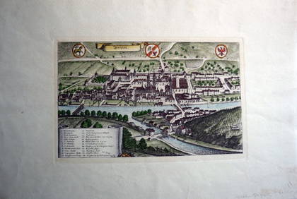
Engraving on Woven Paper Brixen Austria c1850 Hand ColoredLuis Porretta Fine Arts4.3(10)See Sold PriceMar 02, 2024
Caravan Routes in Palestine Linen Map - Germany, 1881Levy Auction House4.3(11)See Sold PriceFeb 27, 2024
Lot of 16 Portraits - Raphael - Michael Stecher Walther - Peder Oxe - Albrecht, archduke of AustriaProverde Auctions4.3(3)See Sold PriceFeb 28, 2024
Joseph Meyer - Set of 50 Prints - Views of Austria - Germany - Italy - Sweden - France - CzechProverde Auctions4.3(3)See Sold PriceFeb 28, 2024
Joseph Meyer - Set of 50 Prints - Views of Austria - Germany - Italy - Sweden - France - UnitedProverde Auctions4.3(3)See Sold PriceFeb 28, 2024
Joseph Meyer - Set of 20 Prints - Views of Austria - Germany - Italy - Torino - PisaProverde Auctions4.3(3)See Sold PriceFeb 28, 2024
Joseph Meyer - Set of 20 Prints - Views of Austria - Germany - Italy - Switzerland - France - SpainProverde Auctions4.3(3)See Sold PriceFeb 28, 2024
Jacques Nicolas Bellin - Antique Map - Vue de la Rade de Tiniam, double antique coast view of theProverde Auctions4.3(3)See Sold PriceFeb 28, 2024
Framed Vintage Style Visscher Commander Repro MapRapid Estate Liquidators and Auction Gallery4.5(1.1k)See Sold PriceMar 01, 2024


![(MAP) VISSCHER, NICOLAUS. [Amsterdam, c. 1690] (1 of 1)](https://p1.liveauctioneers.com/197/30916/12134084_1_x.jpg?height=282&quality=70&version=1342619735)